As you may have heard from the rumbling outside your windows, the forward line of showers and thunderstorms associated with an upper-level system is now moving into the Houston area. This is not the main event, however, as stronger storms remain to the south-southwest of Houston and are steadily moving toward the metro area.
Already the National Weather Service has issued a Severe Thunderstorm Warning for parts of Colorado, Fort Bend, Jackson, and Wharton counties until 12:45pm CT. These storms are bringing heavy rain and wind gusts up to 60 mph.
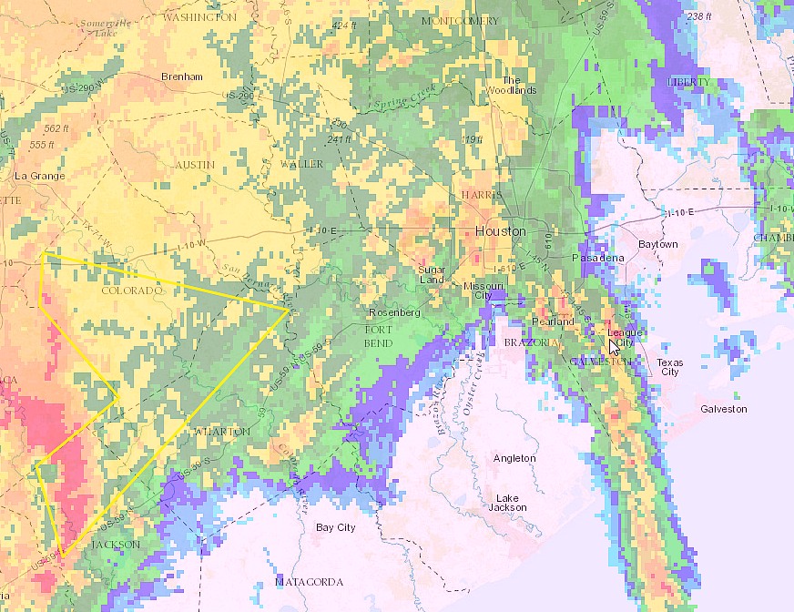
We can expect more of the same for Houston a little later as the bulk of these storms move into he metro area in an hour or two. My primary concern remains the potential for localized flooding where the most intense rains occur. There is the possibility that some of the heaviest storm cells will slow down, or almost stall, as they near the coast. I’m still hopeful the heaviest rain will be out of the area by late afternoon or early evening.
We’ll stay on top of things throughout the event.
Posted by Eric Berger at 12:10pm CT Thursday
ahhhh yes, our weekly monsoon begins.
Hope it doesn’t stall, I really don’t want to get stranded at work
Could you talk a bit about the meaning of “bowing”? How can we tell? What is the effect?
Bowing refers to what a storm looks like on radar. Currently a storm is bowing from about El Campo to Schulenberg, and this simply means that there are strong outflow winds. You will often find damaging winds along the leading edge of this “bow.”
Just started raining on the Ship Channel. Hope it blows through by the commute home.
Looking at this map, I’m thinking the commute home will be a total and complete joy! (Or 90 minutes of misery…)
I think the worst will be out of Houston by 4:30 or 5pm. So there’s some hope.
Eric, it appears these storms are moving NE, is it possible then that Alvin/Pearland won’t get hit as hard? Thanks for always keeping us updated.
Entire area probably at risk for heavy rain, possible strong wind gusts. But storms are continuing to move, which helps.
Thanks for the no hype updates!