Join me in welcoming Matt Lanza to the site

iy1-AGE9
The original Matt Lanza.

Today I’m happy to announce that Matt Lanza will be joining me here at Space City Weather. Matt is an experienced meteorologist with a Houston-based energy company.

You may remember that Matt helped me out at the Chronicle, and he shares my no-nonsense approach to writing about weather. Don’t get me wrong, we both love the weather and are fascinated by it. But we’re not going to hype things up when it’s not warranted.

Anyway, Matt’s great. He’s going to cover things on Fridays, and he’ll help me out during significant weather events so I’m not trying to pull 20 hour shifts and the like. I’m really looking forward to the help.

A few words about the site: At this point we’re basically doing this for free, so the best support you can give is to to continuing liking and sharing us on Facebook and Twitter, and share the link to Space City Weather with your friends. You can also subscribe by e-mail in the box on the right side of this post.

In the less than one month since I started this the site has really grown nicely. Eventually we’d like to find a sponsor, but for now we’re focused on making sure we get the basics right, providing the forecast information you need to know about the greater Houston area. There are a ton of apps to get five-, seven- and 10-day weather forecasts. But those come from machines. My goal here is to provide a reality check, and provide more insight than can be gleaned from a single model forecast.

As always, thanks for your support.
 

Strong cold front arrives Tuesday, pleasant thereafter

Good morning. We’ll have the possibility of strong storms on Tuesday before beautiful fall weather for the rest of the week.

TODAY

We’ll see warm temperatures — near 80 degrees — and muggy air today as moisture returns off the Gulf of Mexico. There will also be a chance of scattered showers and thunderstorms but I don’t expect too much of the area to see rain. We’ll have to wait for Tuesday for that.

TUESDAY

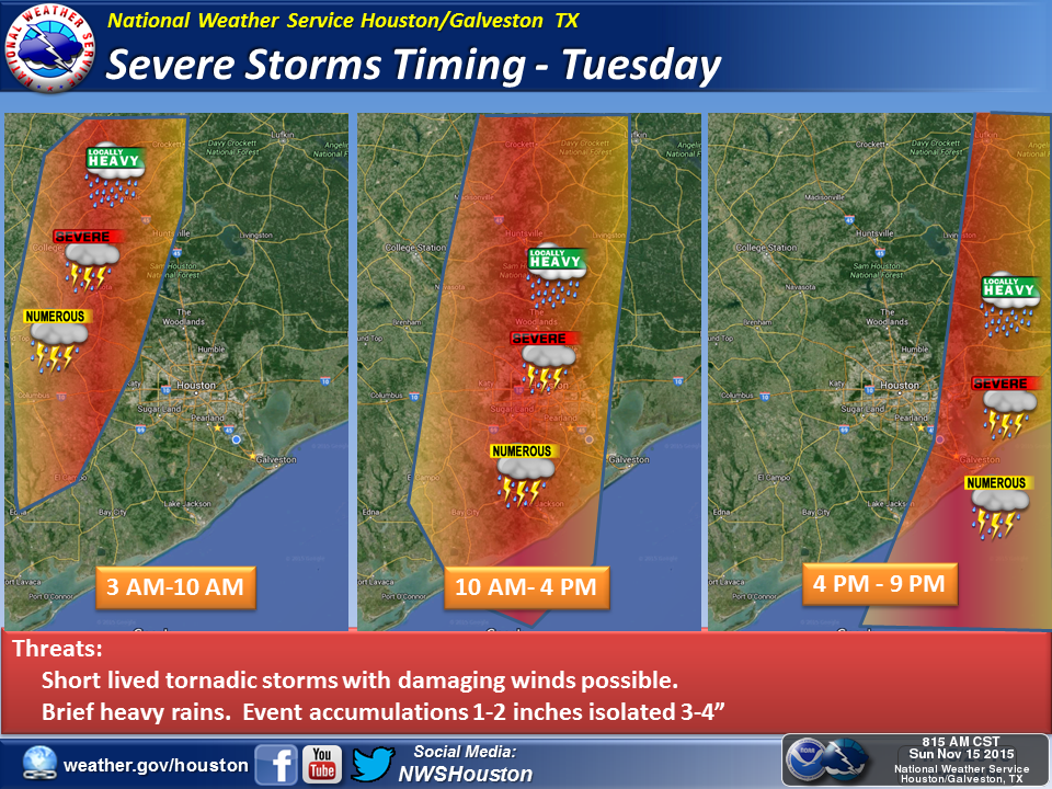
Beginning tonight and especially on Tuesday the region will a good chance of thunderstorms as a strong cool front approaches from the west and then moves quickly through the area. The following map from the National Weather Service shows their best estimates of timing for these storms.

(National Weather Service)

See full post

A quick update on next week’s storms

I hope you’re enjoying the beautiful weather today, which may only be marred by slight rain chances this evening. We’ll have another pleasant fall-like day on Sunday, with only a slight chance of scattered showers. The big concern remains the possibility of severe weather next week.

On Monday, as an upper-level low pressure system moves into the western part of the state, the upper Texas coast will see a warm, and muggy November day with highs near 80 degrees. Scattered showers and thunderstorms will be possible, and we can’t rule out the possibility of severe thunderstorms during the afternoon and evening hours.

This forecast of the mid-levels of the atmosphere on Tuesday night shows the potent upper-level system and conditions for severe weather. (Weather Bell)

See full post

After a pleasant weekend, very severe weather possible Monday and Tuesday

Houston will have three more or less pleasant fall-like days through Sunday, but faces the threat of potentially very severe weather on Monday afternoon through Thursday morning.

TODAY

It’s a chilly start today with most of Houston in the 50s, and under partly to mostly cloudy skies we’re unlikely warm much above the mid-60s. Some sprinkles crossing the northern part of the region this morning will clear out by this afternoon. We’ll have another cool night tonight.

See full post