In brief: Houston will face the threat of heavy rainfall every day this week, but at the same time we also have some uncertainties. It is worth paying close attention to the weather in the coming days. There is a fair bit of nuance in the forecast, so please read carefully.
Assessing Houston’s flood risk
We have dual flood threats this week. The first one, up today and Tuesday, concerns a weak front that will move into the region and provide an impetus for showers and thunderstorms, with heavy rainfall a distinct threat.
Then, later on Wednesday and possibly lasting into Friday, a slow-moving tropical disturbance will bring a surge of moisture into the region and create conditions where very high rainfall rates and serious flooding are possible. However we simply do not know where the greatest rainfall totals from this tropical disturbance will end up.
We are maintaining our Stage 2 flood alert for now across the greater Houston region, but depending on the tropical disturbance we may need to escalate things for the second half of this week. Rest assured Matt and I are continuing to watch this evolving situation closely, and will update as warranted.
Monday and Tuesday
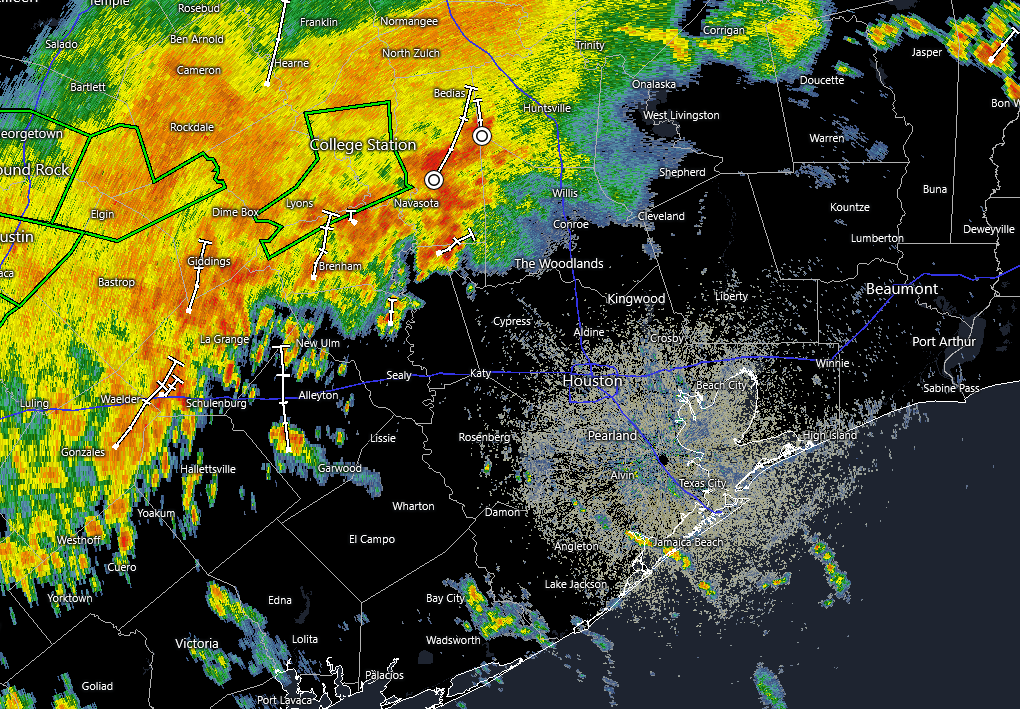
Around sunrise this morning we are seeing a large cluster of storms near College Station and Navasota, and this is being driven by a front (which unfortunately is not going to bring any drier or cooler air with it, this being June and all). Over the course of today this activity will probably move southward, into the Houston region as the weak front stalls over the metro area.
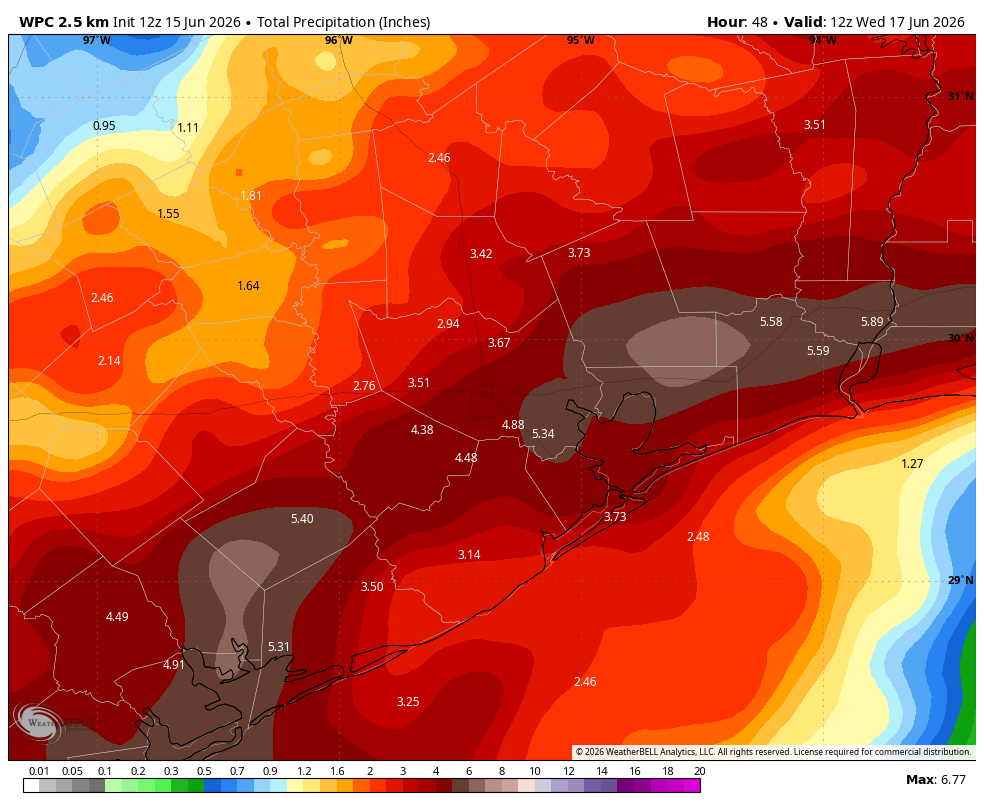
We expect a fairly stormy pattern to persist over the region through Tuesday. That is not to say it will rain all the time, everywhere, but the atmosphere will be very fertile for showers and thunderstorms. We generally expect accumulations of 2 to 4 inches of rainfall during this time period, but you should be prepared for high rainfall rates and local bullseyes of 6 or more inches. This is the kind of rainfall that leads to flash flooding, and hence our call for a Stage 2 flood alert. You will want to be weather aware. Things may calm down a bit by Tuesday evening.
In terms of temperatures, the clouds and rain-cooled air should limit high temperatures to the low- to mid-80s. Conversely, with a very warm and humid air mass in place, overnight lows will not drop too far below 80 degrees. Although we cannot entirely rule out some severe thunderstorms, the primary threat is heavy rainfall.
Wednesday, Thursday, and Friday
This is the period where we have even greater uncertainty, and potentially greater risk. This is due to a low pressure system that is presently just inland over northeastern Mexico. This system should move to the northeast this week, and reemerge over the Gulf of Mexico. After this point it likely will drift toward the upper Texas and Louisiana coasts. It will be slow moving, and bringing a lot of moisture with it, which as long-time residents will know is a potent recipe for a rainmaker.
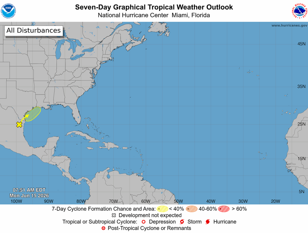
We are talking potential bullseyes of 20 inches, or more, of total rainfall through Friday. As of today we simply do not know where this low will go, precisely, or where its heaviest rains will fall. It is quite possible that the heaviest rainfall occurs over Galveston Bay, or to the east of Houston over Liberty County or even Beaumont-Port Arthur. But we also cannot rule out very serious impacts over Galveston Island or even within Houston itself.
So how should you be thinking about this? It is distinctly possible that parts of Houston will see serious flooding during the second half of this week, but also possible that the heaviest rains will go east and we will be left with a largely manageable situation during the second half of this week. Until there is more clarity in the outcome, we simply cannot say. What does seem clear is that some part of the upper Texas coast, or perhaps southwestern Louisiana, is going to get rocked with some very serious rainfall and flooding in the late Wednesday or Thursday time frame.
When we can say more with confidence, we will.
Saturday, Sunday, and beyond
Rain chances do appear likely to back down somewhat this weekend, although probably not go away entirely. We can probably expect high temperatures in the vicinity of 90 degrees with partly sunny skies. Next week will likely get us back into the lower 90s, with partly to mostly sunny skies. We shall see!
