Splendid weather today and Saturday, but Easter looks mostly gray

It’s quite cool across Houston this morning, with low temperatures in the low 40s up north, and upper 40s to 50 degrees along the coast.

TODAY

In the wake of Thursday’s front we’re going to see beautiful conditions today, with highs around 70 degrees and mostly sunny skies. Enjoy!

SATURDAY

Southerly winds will begin to return Gulf of Mexico moisture, setting us up for a warmer day under partly to mostly sunny skies, with highs around 80 degrees. Still, pretty darn nice.
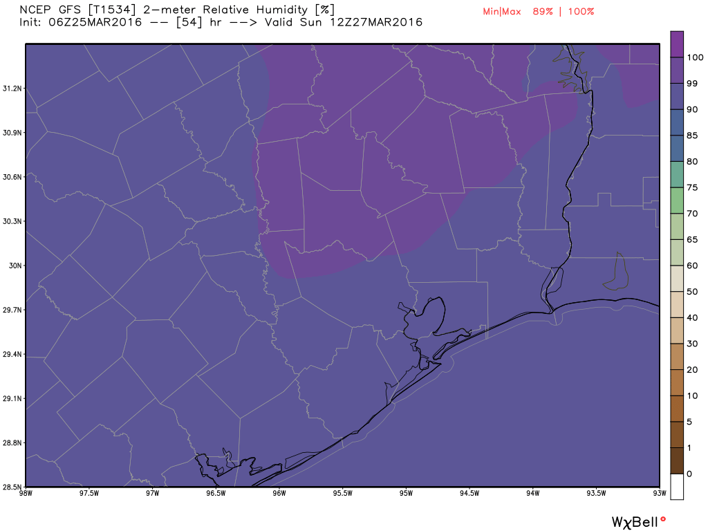
EASTER SUNDAY

The holiday still doesn’t look great, weather-wise, but it could be worse. Sunday looks to be a gray day, starting out muggy. A cool front should reach the area by around noon, but it doesn’t look to be bringing any dynamic weather with it.

With relativity near 100 percent on Sunday morning, expect a muggy start to the Easter holiday. (Weather Bell)

See full post

After storms comes clearing today, and a beautiful Friday

A healthy line of storms is moving through the Houston region this morning, generally bringing 0.25 to 0.75 inch of rain as a cold front moves through.

TODAY

The strongest storms and thunderstorms have now moved east of the area and we should see clearing conditions throughout the morning. Highs today should remain in the 60s and we’ll probably see some sunshine during the afternoon hours. Winds will be brisk out of the north-northwest throughout the daylight hours.

Early morning rain totals. Note: Only Harris County keeps a reliable network of real-time rain stations which is why this map primarily includes rain gauges in Harris County.

See full post

Showers possible late tonight, and again on Easter Sunday

Good morning. It is quite warm across the metro region this morning, with low temperatures only in the mid- to upper-60s across most of Houston and dew points not far behind.

TODAY

We’re going to see another partly to mostly cloudy day today, with brisk southerly winds again bringing up moisture levels across the area. Highs will be near 80 degrees. However a capping inversion, an area of warmer air aloft, should prevent the development of any kind of widespread showers today and this evening. Things become more interesting late tonight as a cold front approaches.

THURSDAY

The front should reach northern areas sometime after midnight, and will perhaps move through the city a bit before sunrise and should be off the coast by mid-morning. The front should perturb the atmosphere enough to break the capping inversion discussed above, and most areas might see two to three tenths of an inch of rain, but this is not going to be a real gully washer.

Rain accumulations from a frontal passage tonight and early Thursday should be greater for inland areas. (Weather Bell)

See full post

Breezy today as southerly winds return, front coming Thursday morning

Good morning. It’s cool again this morning, with temperatures in the mid-40s to about 50 degrees. But we’ll warm up pretty quickly.

TODAY

We’ll see increasingly strong southerly winds today with a tight gradient stretching from high pressure in the Gulf of Mexico toward lower pressure centered over Colorado, Nebraska and Kansas. This should bring some clouds later today, due to increasing moisture levels, as highs climb into the mid-70s. Low temperatures tonight will only fall back to around 60 degrees.

The mid-level of the atmosphere forecast for today shows the distinct pressure gradient. (Weather Bell)

See full post