Houston warms later this week, but a strong front looms by Friday or so

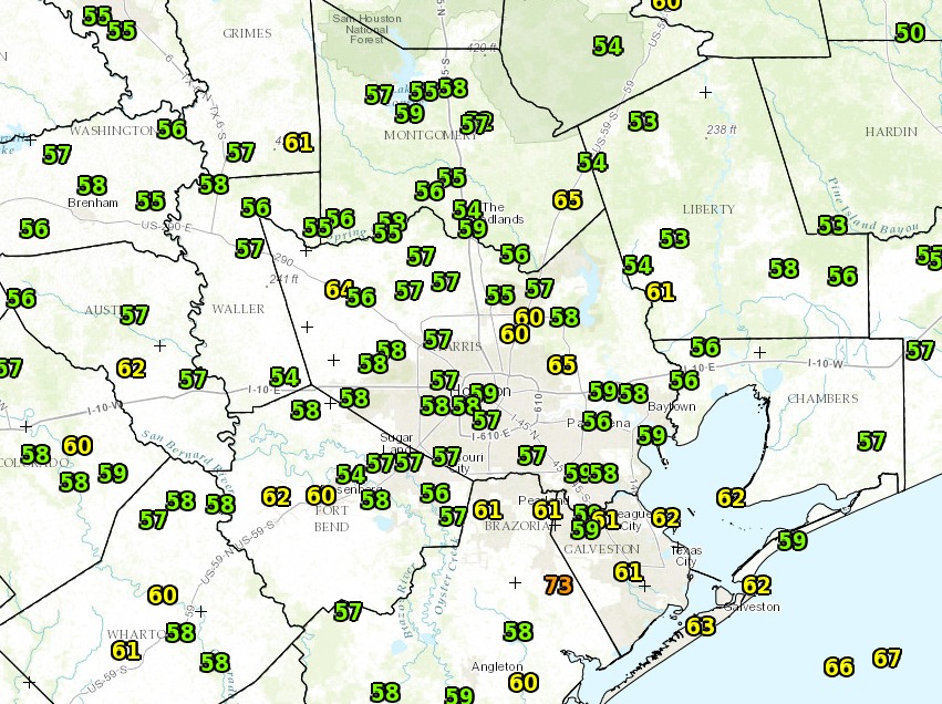
It is a clear, cool fall morning across the Houston region, and although we will see gradually warming temperatures toward the end of the work week, another cool front will arrive by next weekend to keep conditions fall-like.

Temperatures at 6:15am CT across the region on Monday. (National Weather Service)

Today

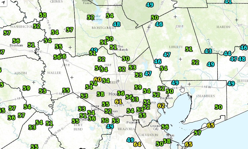
Skies cleared this morning for great conditions to view the Supermoon, which set at 6:39am this morning. It will still look great tonight. Meanwhile temperatures will rise into the upper 70s today under partly to mostly sunny skies. Lows tonight won’t be nearly so cold, likely only falling to around 60 degrees for most of the region.

Tuesday and Wednesday

The region will receive another shot of drier air on Tuesday, and this combined with full sunshine will allow temperatures to reach about 80 degrees. But because it shouldn’t be excessively humid, it will feel quite pleasant outside. Lows will range from the upper-50s to lower-60s.

Thursday

As high pressure builds over the Houston we’ll see the return of more humid conditions beginning later on Wednesday and into Thursday. Highs Thursday should be in the low-80s, and I wouldn’t expect lows to fall much below 70, if at all, on Thursday night and Friday morning. Under partly to mostly cloudy skies it will feel quite humid. But this return of wamrer weather will be short-lived.

Friday morning's low temperatures will be 10 to 12 degrees above normal. (Weather Bell)
Friday morning’s low temperatures will be 10 to 12 degrees above normal. (Weather Bell)

See full post

Houston’s weather in a word: Quiet

First off, a very happy Veterans Day to those who have served and defended our great nation. We owe you our deepest gratitude for your service and sacrifices. Thank you!

On to our weather. If you were looking for a nice, quiet autumnal weekend, I think you’re going to find one the next few days.

Today through Sunday

The biggest forecast challenge I see is cloud cover.

Water vapor satellite loop shows an upper low spinning over SW Texas and New Mexico and high clouds streaming over East Texas. (College of DuPage)


An upper low well to our west and ample jet stream energy off the Pacific are helping to keep a high deck of clouds in the forecast the next couple days. If you look at weather model data, this upper low is forecast to basically shear itself apart and open up before being ejected off to the east later this weekend.

Approximate location of upper level disturbance through Sunday night/Monday AM. (Weather Bell)


What does it mean for you? Expect intervals of clouds and sunny breaks today and tomorrow. We should probably see more of the same Sunday also, though we could see gradually decreasing clouds. Temperatures will vary based on clouds. If we see a lot of clouds, expect daytime highs in the upper 60s to around 70 and nighttime lows in the upper 50s. If we get a fair amount of breaks in the clouds, we’ll do low to mid 70s for highs and upper 40s to mid 50s for lows. Basically, it looks like a fair weather fall weekend here in Southeast Texas, with no serious rain risk.

See full post

Houston’s weather mostly sunny, and pleasantly cool through the weekend

As promised temperatures are clear and cool this morning across the Houston metro area, ranging from the low 50s northeast of the city to low 60s right along the coast, in places like Galveston Island. This is how it will be for awhile, so enjoy!

Houston area observed temperatures at 6:30am CT.  (National Weather Service)
Houston area observed temperatures at 6:30am CT. (National Weather Service)

Today

With primarily northeasterly winds we’ll continue to see drier air move into Houston. We’re seeing this flow in response to a large, upper-level low pressure system in northern Mexico, to the southwest of our region. It should allow skies to clear some later today, but keep high temperatures in the lower 70s. One consequence of this northeasterly flow will be higher tides along the Texas coast, perhaps as much as three feet above normal. the National Weather Service says.

Friday and Saturday

Conditions will remain more or less the same heading into the weekend, and we will certainly have fitting weather to mark Veterans Day. Look for partly sunny to mostly sunny skies both days, with highs in the mid-70s, and lows in the 50s except for along the coast. Hard to beat that as we show appreciation for those who serve in the US military.

Temperatures may warm back to a few degrees above normal later next week. (Weather Bell)

See full post

Good morning, Houston. Our forecast is nearly perfect.

Good morning, everyone. I suspect many people are groggy after following the elections last night. We promise there will be no politics here, only the best possible forecasting. And as we saw last night with pre-election polls, forecasting the future is difficult. Kindly remember that the next time a major rain storm threatens the Houston area, and then busts.

Today

Regardless of how you feel—relieved, giddy or terrified—Houston’s forecast will help. We’re going to have one more moderately humid morning as drier air works its way into Houston. A few very isolated areas of light rain are possible this morning as that happens, but most people won’t see any rain. With mostly cloudy skies today highs should only climb into the mid-70s.

Cooler air is coming to Houston today, but it's lagging behind the front this morning. (Weather Bell)
Cooler air is coming to Houston today, but it’s lagging behind the front this morning. (Weather Bell)

See full post