In brief: Our rain chances are not entirely going away over the next several days, but they will take a back seat to increasing temperatures. By Sunday or Monday, most of the region is likely to record their first 90-degree day of the year. Please clap.
90 degrees, soon?
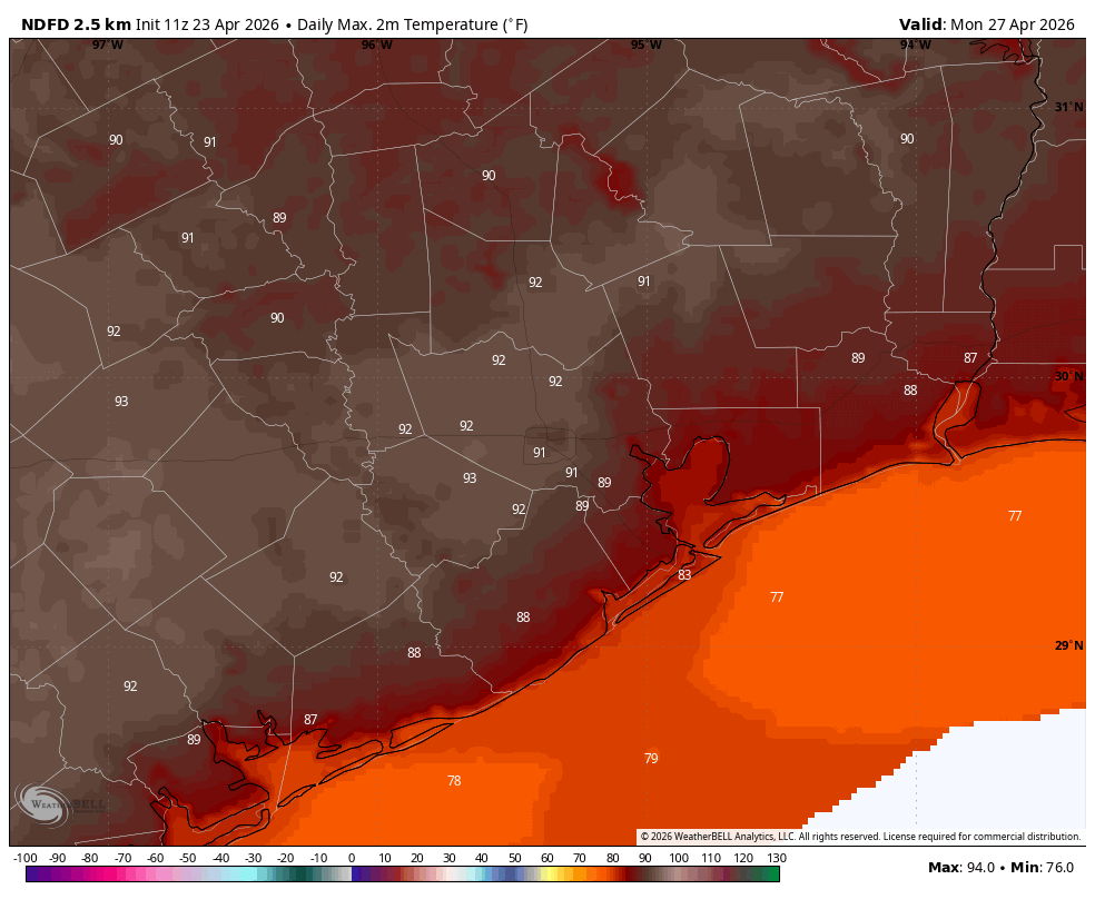
After a rainy period over the last five days, which has brought 2 to 5 inches of much needed precipitation to most locations, Houston’s days will now become a little sunnier and quite a bit hotter. How hot? It is likely by Sunday or Monday that the Houston region will see its first 90-degree day.
Yes, a few spots in Houston have already hit that mark this year, but officially the region’s hottest day came on March 21 when the high temperature at Bush Intercontinental Airport reached 88 degrees. So far, our average high temperature this month has been below 80 degrees. The bottom line is that, after today, Houston is going to experience is longest, and hottest period so far of the year, as well as a foretaste of what is to come next month and beyond as summer slides into the region.
Thursday
After several mostly cloudy days, Houston will see at least partly sunny skies today, and this will allow for temperatures to generally warm into the mid-80s. As will be the case for the next week, our dewpoints will be at a level (about 70 degrees) such that our air is very humid. Get used to it. Winds during the afternoon will gust up to 20 mph or so from the south. Rain chances are not zero today, but they are close to it, with only a few very isolated, short-lived showers possible. Low temperatures tonight will only drop into the vicinity of 70 degrees.
Friday
A frontal boundary will approach the region from the north, but stall out well before moving into the Houston metro area. The question is whether instability from this front can spark any showers or thunderstorms in the Houston area. It’s a low-end possibility throughout the weekend, but perhaps the highest chance (10 to 20 percent) will occur on Friday afternoon and evening. Otherwise this should be a partly to mostly cloudy day with high temperatures in the mid- to upper 80s. Nights remain warm and muggy.
Saturday and Sunday
Both weekend days should see a mixture of sunshine and clouds. It remains to be seen whether lingering instability and daytime heating can spark any showers or thunderstorms. My sense is probably not, but it will be something to consider should you be outdoors on the MS 150 ride. Be aware of your surroundings. Otherwise, high temperatures should approach 90 degrees on Saturday, and quite possibly reach it on Sunday for large parts of Houston. Winds will be from the south, gusting up to 20 mph or so during the afternoon hours. Overnight lows probably will only reach the lower 70s.
Next week
Right now it appears our hottest weather of the year, to date, will come early next week when Monday and Tuesday bring highs of 90 degrees or thereabouts across much of the region. Each afternoon will have a slight chance of showers, driven in part by the sea breeze. Better rain chances arrive by Thursday or Friday, when some sort of a front is likely to move into the area. This should bring at least temporary relief from very warm highs and the humidity.
