It is a clear, cool fall morning across the Houston region, and although we will see gradually warming temperatures toward the end of the work week, another cool front will arrive by next weekend to keep conditions fall-like.
Today
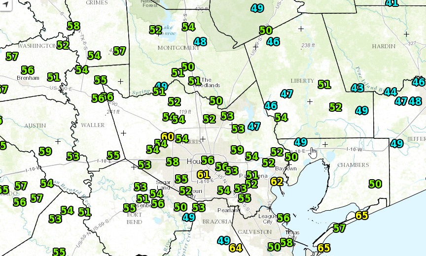
Skies cleared this morning for great conditions to view the Supermoon, which set at 6:39am this morning. It will still look great tonight. Meanwhile temperatures will rise into the upper 70s today under partly to mostly sunny skies. Lows tonight won’t be nearly so cold, likely only falling to around 60 degrees for most of the region.
Tuesday and Wednesday
The region will receive another shot of drier air on Tuesday, and this combined with full sunshine will allow temperatures to reach about 80 degrees. But because it shouldn’t be excessively humid, it will feel quite pleasant outside. Lows will range from the upper-50s to lower-60s.
Thursday
As high pressure builds over the Houston we’ll see the return of more humid conditions beginning later on Wednesday and into Thursday. Highs Thursday should be in the low-80s, and I wouldn’t expect lows to fall much below 70, if at all, on Thursday night and Friday morning. Under partly to mostly cloudy skies it will feel quite humid. But this return of wamrer weather will be short-lived.
Friday
A robust cold front should move through Houston some time on Friday, bringing a significant change from mid-week conditions. As there likely won’t be too much moisture for the front to work with, I’d expect a broken line of storms rather than a large, organized system of showers and thunderstorms accompanying the front. Accumulations should be well under an inch for nearly everyone. Highs Friday should reach about 80 degrees ahead of the front.
Saturday and Sunday
As cooler and drier air moves into the region we’ll see a fall-like weekend. Expect highs of around 70 degrees on Saturday, and only in the 60s on Sunday. By Sunday and Monday morning lows should fall into the upper 40s for most of the Houston area, except for along the coast. Looking way ahead, although we’ll warm up a bit next week after the front, I’d only look for a high of around 70 degrees on Thanksgiving. But that’s a long ways away to have any confidence in the forecast.
Posted at 6:40am CT by Eric
Eric –
The forecast is almost good enough for backyard football on Thanksgiving to feel like back home, but do you think you could knock the temps back about 20 degrees just for the afternoon? 50 would be OK, but 45 would be perfect!
It’s going to be considerably cooler this weekend, like really really nice, but definitely not that cool!
Check back in December…