On the last day of May conditions are warm this morning, with almost summer-like readings in the 70s. A few rainy days could keep the low-90s heat away from us for the next week or so, however.
Today
It will be another warm day, with highs likely reaching into the upper 80s this afternoon. This daytime heat should combine with moisture to produce a decent chance of showers and thunderstorms this afternoon. I’m not anticipating widespread coverage, but for areas that do see rain, that rain could briefly be quite heavy.
Thursday
This should be a wetter day for the region, as moisture surges into the area from the south. We should expect widespread showers and thunderstorms, again, with some localized deluges possible. Mostly cloudy skies should help keep highs in the mid-80s, and most areas probably will see on the order of 1 inch of rain, or slightly less.
(Space City Weather is sponsored this month by Jetco Delivery)
For weather forecasters, air quality remains one of the trickier things to predict. Several factors go into making good air quality forecasts, because so many weather events influence air pollution. As Houston heats up and air quality becomes a greater concern this summer, we wanted to talk a little about what air pollution is, and the part weather plays in it.
Primary vs. Secondary pollutants
Air pollution consists of two types: primary and secondary. Primary pollution comes directly from a source, like car and ship exhaust, power plant emissions, fires, etc. Secondary pollutants, on the other hand, aren’t emitted directly into the air. Instead, chemical reactions in the atmosphere create these pollutants. Ozone, for example, forms when sunlight interacts with nitrous oxide, carbon dioxide, and other “volatile organic compounds”, or VOCs. Ozone in the stratosphere (think of the ‘ozone hole’) acts as an invisible sunscreen layer for earth, preventing UV rays from reaching the surface. However, ozone near the surface, or ‘smog’, acts as a respiratory irritant. The more sunlight we get during a day, the more potential there is for smog.
The many sources of air pollution. “Chemical transformations” are another way to describe secondary pollutant creation (Science Direct)
Good morning. After some storms on Sunday night, Houston’s weather remained mostly calm on Memorial Day. As we enter June the region should remain in this gray pattern, with on-and-off rain chances for most of the rest of this week. This isn’t great weather for those who are looking for sunshine, but if you’re hoping to put off the start of Houston’s summertime slog of 90-degree days, you’re in luck.
Today
Despite the mostly cloudy start this morning, Houston might actually see some sunshine later today—if only briefly. Moisture levels aren’t that high, so I’m only expecting a few scattered showers to go along with highs in the mid- to upper-80s. Overnight lows will be in the low to mid-70s for most of this week.
Wednesday
As moisture levels pick back up on Wednesday, we’ll see somewhat better rain chances, and we can’t rule out of a few scattered, heavy rain storms during the day. Highs should be in the mid-80s with mostly cloudy skies.
(Space City Weather is sponsored this month by Jetco Delivery)
Thursday and Friday
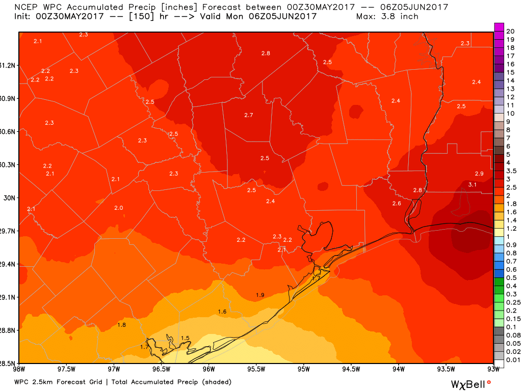
By Thursday an upper-level disturbance should combine with fairly high moisture levels to produce a really healthy chance of rain across the Houston area. While we can’t rule out flooding given the time of year and moist atmosphere, it looks like these storms should produce 1 to 2 inches of rain to end the work week for most people, rather than an absolute deluge. We’ll be watching it closely regardless. Highs should remain in the mid-80s.
Rain accumulation forecast for now through Sunday. (Weather Bell)
Next weekend
The forecast for this weekend isn’t particularly clear, but the best bet is that we’re going to remain in this quasi-moist regime, with decent rain chances and partly to mostly cloudy skies. At this point I don’t think we’re looking at any significant flooding, but that remains a potential threat that we’ll have to look out for. This pattern may hold through the early part of next week before we finally see clearing conditions and characteristically warmer summer days in the low 90s. Honestly, there are worse ways to begin the month of June—such as with a tropical storm or highs in the 100s.
After a quiet start to Memorial Day weekend we have some concerns about the second half of the holiday for the greater Houston area as our weather turns stormy. The problems should develop later this afternoon and evening as a weak front approaches the region from the northeast at about the same time as temperatures reach their warmest levels around 90 degrees.
Sunday afternoon and evening
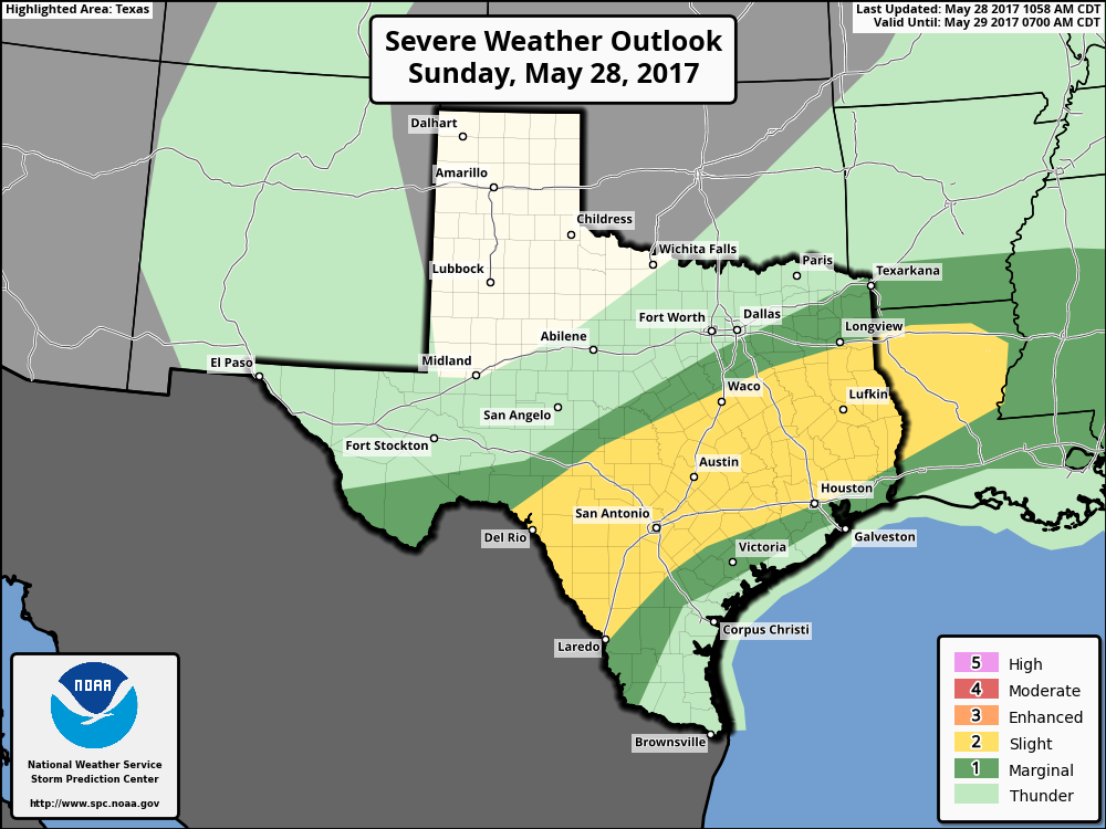
For today, the principal area of concern is north of Interstate 10, where increasingly unstable air should allow for the development of thunderstorms, some of which could become severe. We’re going to have to watch for the possibility of damaging winds and hail, as well as some brief, localized flooding. I would not be surprised to see some areas pick up a quick two or three inches of rain in a short period of time.
NOAA Severe Weather Outlook for Sunday and Sunday night. (NOAA)
Memorial Day
The forecast for Memorial Day is fairly complicated, because in addition to the diffuse frontal system, an area of disturbed weather is likely to move up the Texas coast, from Mexico. This could drive some rain showers and thunderstorms along the coast during the morning and midday hours, adding to the mess.
Overall, the likelihood of intermittent storms is fairly high for the Houston area through the holiday weekend, from Sunday afternoon, onward. While I’m not too concerned about flooding issues, I do expect most of the region to get 1 to 2 inches of rain, with higher isolated totals. For most of next week, the weather appears likely to remain unsettled, which isn’t a terrible way to start June as it will keep highs in the 80s, rather than the low 90s. But we will have to watch for potential flooding later in the week, depending on just how much rain comes between now and then.
Posted by Eric at 11:20am CT on Sunday by Eric
(Space City Weather is sponsored this month by Jetco Delivery)