Harvey to re-form soon, bring flooding to the Texas coast

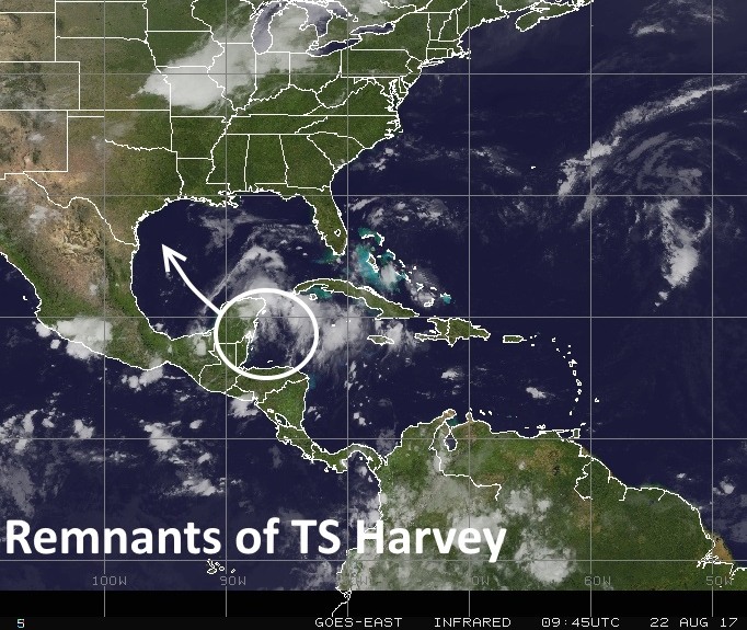
Houston will see continued warm weather—with highs in the low- to mid-90s—and scattered showers during the next couple of days, but our principal focus remains on the likely redevelopment of Tropical Storm Harvey, and its eventual movement toward Texas. Parts of the state will be be utterly soaked by the end of this weekend, and some flooding seems inevitable.

Tropical Storm Harvey at 6am CT on Wednesday. (Space City Weather/NOAA)

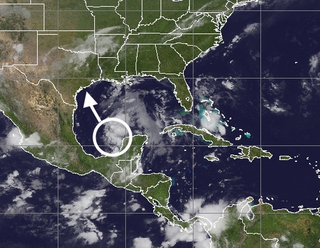
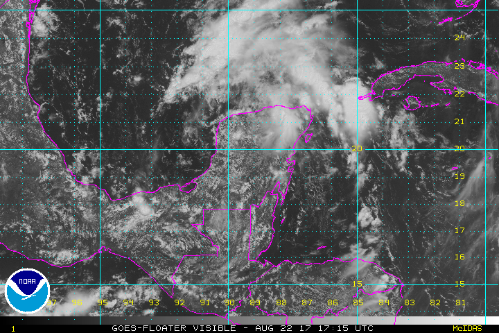
As of 6:30am Wednesday, a reconnaissance aircraft is flying around the large area of disturbed weather in the southern Gulf of Mexico, and may find a tropical depression. Some dry air appears to be slowing development right now, but the Gulf is warm and wind shear manageable, so some intensification is likely as the system moves northwest toward Texas during the next couple of days. While we cannot rule out rapid intensification, a phenomenon which is still relatively poorly understood, it is probable that Harvey will come ashore as a tropical storm or Category 1 hurricane. A landfall between Corpus Christi and Matagorda seems most likely at this time. While we may see some storm surges of 3 to 5 feet with such a storm, and tropical storm-force winds, rainfall is by far the biggest concern.

See full post

Yeah, this weekend is looking wet for Texas

Until the remnants of Tropical Storm Harvey are no longer a threat to Texas, we’ll be posting multiple times a day on this site to provide the best available information. Unfortunately, after looking at the latest model data we continue to be concerned about the potential for this tropical system to bring heavy rains to the Texas coast and some inland areas this weekend, and early next week.

As of Tuesday afternoon, the remnants of Harvey are crossing the Yucatan Peninsula, and it appears almost certain that the storm will re-form over the southern Gulf of Mexico during the next 24 to 48 hours.

As of Tuesday afternoon Harvey had not re-formed. Yet. (NOAA)

The forecast models suggest the storm will then move toward the northwest, and come ashore somewhere on Friday(ish) between Brownsville, at the southern end of Texas, and Freeport, which is just down the coast from Galveston. This afternoon, NOAA’s G-IV Hurricane Hunter Jet will fly around the remnants of Harvey, and this should provide useful information that will improve forecast model output tonight, and especially on Wednesday. But frankly, our biggest concern is not where undead Harvey makes landfall (rain, not winds, are most likely the primary threat here), but rather what happens after the storm moves inland. This is because the upper-air pattern later this week and weekend is such that there will be little to steer the movement of the system, and therefore it may wobble around. When you have a tropical system near the warm, moist Gulf of Mexico, this is a bad thing because it means rainfall. Potentially a lot of rainfall.

See full post

Texas faces a tropical threat later this week, heavy rains possible

Houston enjoyed reasonably good weather for the partial eclipse on Monday, and perhaps what was most striking to me is how pleasant it felt outside shortly after 1pm, when about two-thirds of the Sun was obscured by the Moon. If only every August afternoon felt like that. In any case, it is now time for us to focus on the weather, with the potential for a very wet weekend due to tropical moisture.

Photo taken of the eclipse maximum, from Friendswood, with Celestron 8″ telescope. (Darrell Lee)

Tuesday through Thursday

Houston will remain in a summer-like pattern for most of the rest of the work week—with highs in the low- to mid-90s and scattered afternoon showers—with a few twists. Most notably, a cool front will sag into the northern parts of the Houston region by late Wednesday or so, and while this won’t provide much relief from the heat it could raise rain chances a little bit.

See full post

Clouds may eclipse the eclipse, and rain chances return to Houston

After very hot and dull weather for the last week or 10 days, our region will see more dynamic conditions during the week ahead as the high pressure system breaks down. This will lead to generally better rain chances and slightly cooler weather.

Today

As most everyone knows, a total solar eclipse will cross the United States today, in a line from Oregon through South Carolina. The Houston area will see about 70 percent of the Sun obscured by the Moon (do not directly look at the Sun), with the maximum coverage at 1:16pm CT. We are going to have to be concerned about clouds today, but for the most part they should be broken enough to see the phenomenon at times (the partial eclipse begins at 11:46am CT and runs through 2:45pm). I’d expect 40 to 60 percent sky cover for most of the area shortly after noon today.

GFS model for cloud cover at noon CT today. Whiter means more cloudy. (Weather Bell)

The region will also see some scattered showers and thunderstorms this afternoon as pressures fall and atmospheric moisture levels rise, which could be hitting around the time kids are coming home from the first day of school. Where it doesn’t rain, look for highs in the low- to mid-90s.

Tuesday and Wednesday

These will be typical summertime days in Houston, as there will be no major forcing events for our weather. With slightly lower pressures, look for highs in the mid-90s, with partly sunny skies, and about a 30 percent chance of showers and thunderstorms during the afternoon and early evening hours.

See full post