Thursday, 3:30pm CT—I hope everyone is enjoying the pleasant weather. At mid-afternoon the temperature in Houston is 90 degrees, with 45 percent humidity and mostly sunny skies. It is hard to beat this for the end of August. With that said, we wanted to provide a quick look at three tropical systems of interest because there’s been some chatter and concerns about them.
(National Hurricane Center)
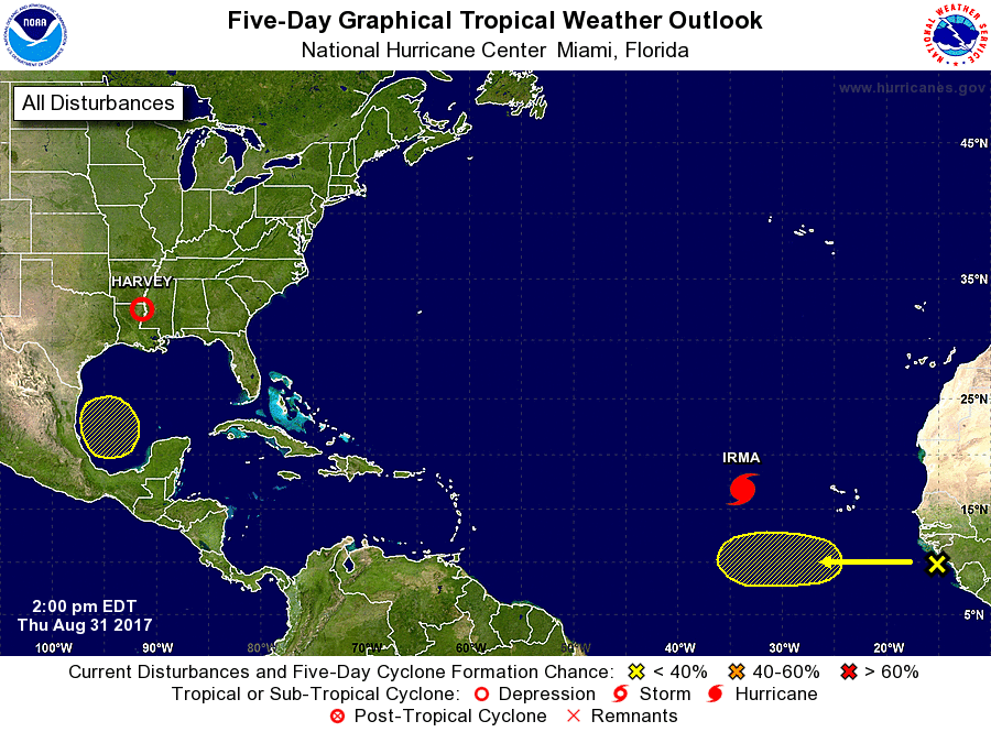
Yellow blob near Texas
When we see low pressure systems in the Gulf at this time of year, normally we’re pretty nervous. However a cold front seems likely to move into Texas next week (reaching Houston perhaps by Thursday), and this should keep any tropical mischief south of the upper Texas coast. At this time we do not have major concerns about heavy rainfall next week, although we’ll continue to monitor the forecast. What we are doing is starting to get excited about the season’s first cold front, arriving about two weeks early (if it does in fact make it through).
Houston’s fine weather will continue for the next several days—it’s difficult to believe we’re at the end of August—before some rain chances return. This post will discuss two potential tropical threats (neither of which we’re particularly concerned about at this time) and the increasing likelihood of the region’s first cool front next week.
Thursday through Sunday
Expect perfectly benign, sunny conditions, with highs of around 90 degrees, lows in the lower 70s, and light winds. The overnight lows are courtesy of drier air moving in on the backside of Harvey as it lifts into the Midwest over the next couple of days. Onshore winds resume by the weekend, and there’s perhaps a slight chance of showers on Sunday, but nothing to be concerned about from a flooding standpoint.
According to TxDot and its continually updated map, more roads are opening around Houston as the bayous drain, but plenty of roads remains closed to the southwest and northeast of the city.
Labor Day and Tuesday
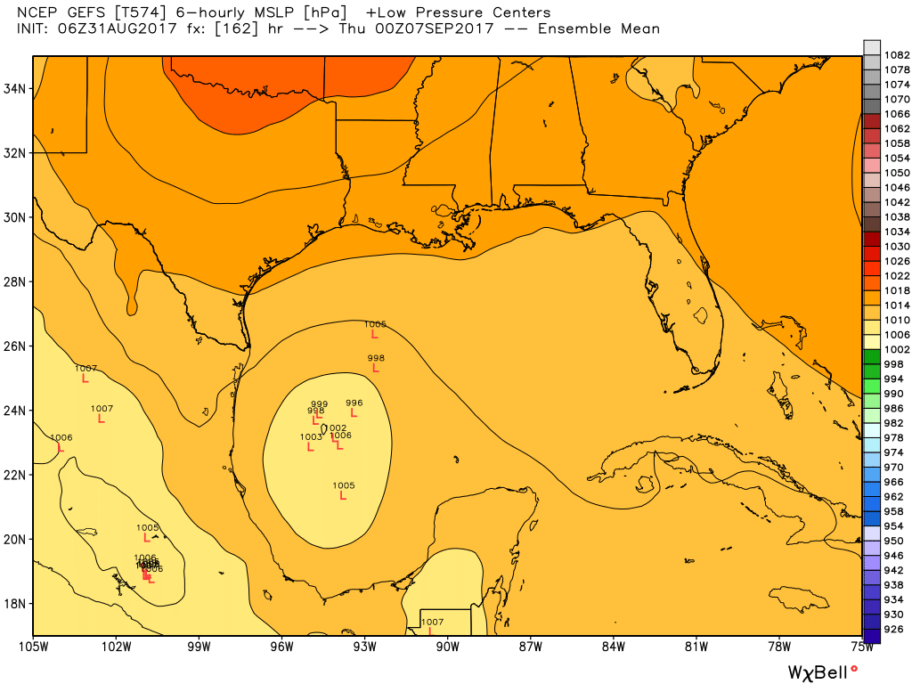
By late this weekend, a low pressure system may move into the southern Gulf of Mexico, and the National Hurricane Center says it has a 20 percent chance of developing into a tropical storm or depression over the next five days. Some people on social media have been expressing concern about this storm, but we remain pretty confident it won’t be a significant threat to the hard-hit Texas coast. It’s worth noting that the GFS model (which had been bringing a lot of rain into Houston next week) has now backed way off. See how far the ensemble run of the model keeps the low pressure system away from Texas.
Ensemble forecast from GFS model for tropical low locations next Wednesday night. (Weather Bell)
With that said, we do expect the return of some clouds and rain chances next week, beginning on Labor Day and probably running into Wednesday. Right now I’d say we’re looking at anywhere from a few tenths of an inch of rain to about an inch, most likely. If this forecast changes, we’ll of course let you know.
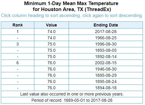
Wednesday, 2pm CT—Anyone who walked outside on Tuesday evening—and it sure did feel almost spiritual to see the sun, didn’t it?—surely also felt the comfortable temperatures outside. It was, in fact, amazingly cool during the height of Harvey. High temperatures on Sunday (77 degrees), Monday (74) and Tuesday (75) were uncharacteristic to say the least. They were, in fact, record setting.
I checked in with Brian Brettschneider (@climatologist49 on Twitter, and a fun follow), and he came up with the following table. In it, we can see that Monday’s high temperature tied August 25, 1966 as the coolest day in the entire month of August, in Houston, in more than 120 years of records. Tuesday’s high tied for third.
All time low maximum temperatures for August days in Houston. (Brian Brettschneider)
Brian believes the 1966 high temperature of 74 degrees was caused by an early cold front, with lower dewpoints, cloud cover, and an overcast day. This Monday’s cooler temperatures were, of course, caused by Harvey, which by that point was drawing northerly winds into Houston, and along with cooler air, this somewhat drier northerly air also allowed for evaporative cooling as the rains fell. This was the only nice thing about Harvey.
Wednesday, 7:50am CT—It is an absolutely amazing morning in Houston—humidity is low for August, temperatures are in the low 70s, and the sun can be seen as it rises above the eastern horizon. The only trace of our recently departed Hurricane Harvey is some northwesterly winds gusting into the mid-20s. But even those should die down today.
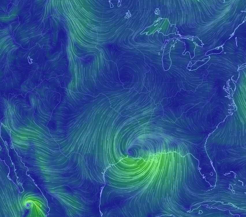
Speaking of Harvey, the storm has made its final landfall this morning, and is now located near Lake Charles, La. The storm continues to lash the Beaumont and Port Arthur area with rains (because clearly Harvey has a seething hatred for all things Texas), and they are seeing similar conditions as Houston earlier this week. Those areas should begin clearing later today too as Harvey moves steadily northeast. Let’s discuss the forecast, and also address the concerns some of you have about tropical weather next week.
Harvey has come ashore, and is bringing northwesterly winds to Houston. This will help drain bayous faster. (earth.nullschool.net)
Today
Skies will be partly sunny, and we expect high temperatures to rise into the upper 80s. Rain chances should be near zero. Brisk northwesterly winds will help drain bayous, too.
The National Weather Service this morning urged people not to “sightsee” in damaged areas as the weather improves, and I would echo these sentiments. There are still dangers in some areas—and let’s be honest, if your home was destroyed would you want gawkers coming by to survey the damage? Heck no. Respect your fellow citizens, and the first responders taking the first steps to getting our city on the road to recovery.