More frequent rain chances for Houston

After an autumn that has seen Texas slip into drought and cooler weather than we’ve had the last couple years, we’re now adding a more active pattern with a few more rain chances to boot. A lot to cover, so let’s dive in.

Today

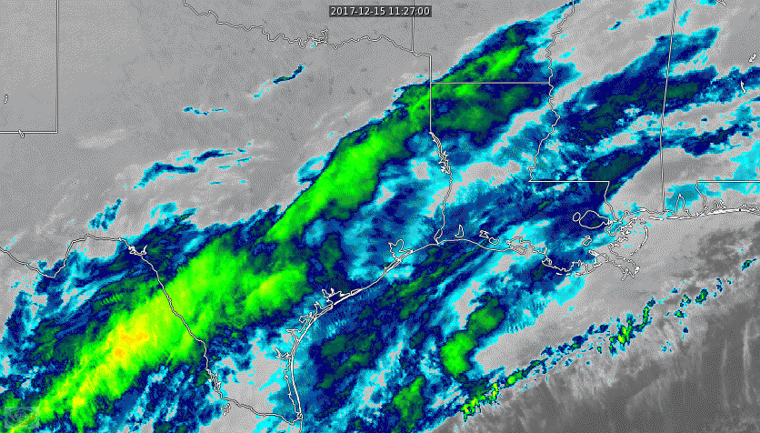
Today is a day where we need two or three forecasts for the area. You can see that on this satellite image from this morning.

GOES-16 satellite imagery is back online and officially operational. The back edge of clouds will try and push southeast today but it may not make it to Houston. (Univ of Wisconsin SSEC)

At the coast: Expect clouds and a chance of showers or periods of light rain. The steadier rain will stay offshore, but if you live within 20 miles of the Gulf, you will probably see some raindrops at times today, especially in the morning. Inland from there, including most of the Houston metro area, we’ll just be cloudy. Some light rain or drizzle is possible southeast of town in the morning, and some sunshine is possible in Houston and northwest during the afternoon. Further northwest of Houston, expect a mix of sun and clouds to develop. Temperatures will range from the mid-50s south and east to the mid or upper-50s with clouds and sun north and west.

Saturday and Sunday

Saturday will see a change, as a brief surge of onshore flow leads to increasing rain chances as the day goes on. If you have outdoor plans, the morning might be your safest bet. Expect scattered showers or thunderstorms to break out from west to east Saturday afternoon and evening as a cold front approaches. Rain may be briefly heavy at times, along with some strong or even severe thunderstorms (mainly south and east of Houston) overnight Saturday. Right now, any severe weather looks pretty isolated and mainly east of the area. If this changes, Eric or myself will update you tomorrow.

Rain should quickly end from west to east across the area probably between about 12 and 3 AM Sunday.  The exception to this may be along the coast, where a few showers will linger through Sunday morning. Total rainfall for this event will probably be a half inch to an inch on average, with a few spots perhaps picking up one to two inches of rain.

NWS forecast of total rainfall through Sunday evening shows around an inch in most of the area. A few places will see more, others less. (NWS/Weather Bell)


Temperatures will top off in the upper 50s Saturday afternoon, then drop off behind the front Saturday night into the lower-50s. Sunday should see improving conditions with a bit of sunshine and highs in the mid to upper-60s.

(Space City Weather is brought to you this month by the Law Office of Murray Newman)

See full post

Houston’s weather pattern turns wetter, and eventually a bit warmer

After a week without rainfall, the region will see some decent rain chances over the next several days. That’s not to say we are going to see a total washout, but there’s the potential for a solid 1 to 2 inches of rainfall between now and next Wednesday, with isolated areas seeing a little more. Let’s take a more detailed look at the forecast.

Rainfall accumulation forecast for now through Wednesday morning. (NOAA/Weather Bell)

Thursday

Today will be the last day with a near zero chance of rainfall, even as a cold front moves through later on this afternoon. Look for partly to mostly cloudy skies, with a high temperature in the mid- to upper-60s. This is pretty typical weather for December.

Friday

After the front we may see some scattered showers tonight, with rain chances best to the south of Houston, from Galveston down the coast to Matagorda Bay. Most likely, central parts of Houston won’t see much if any rain on Thursday night and Friday morning. The day itself will be cold, with highs likely remaining in the 50s under mostly cloudy skies. Overnight lows on Friday will fall into the low 40s for most of Houston, with upper 30s for inland areas in Montgomery County, and warmer conditions along the coast.

(Space City Weather is brought to you this month by the Law Office of Murray Newman)

See full post

Rain returns this weekend, and Christmas still looks chilly

Temperatures have fallen to freezing levels for some areas north and west of Houston this morning, although most of the city and coastal areas have remained a few degrees above this threshold. It is nonetheless a cold winter morning out there, so don’t forget to bundle up yourself and your loved ones this morning.

Much of Texas is seeing freezing temperatures this morning. (Weather Bell)

Wednesday and Thursday

Sunny skies this morning will help warm things up across the region, with high temperatures today reaching the mid-60s. Lows tonight will probably be 5 to 10 degrees warmer than Tuesday night, so we shouldn’t see any freezes. Another pleasant, partly sunny day is on tap for Thursday with highs in the mid-60s. However, before the weather can warm up too much, another cool front will move into the region on Thursday. There is a slight chance of some rain on Thursday night and into Friday morning along the coast, but as of now I expect the region to remain mostly dry.

Friday

In the wake of Thursday’s front, Friday morning will start out cold, but not freezing for Houston. Temperatures probably will warm only into the 50s under partly sunny skies, and with a cool northerly breeze. Chilly.

(Space City Weather is brought to you this month by the Law Office of Murray Newman)

See full post

Cool and pleasant this week, with a healthy chance of rain Sunday

A cold front quietly moved through Houston during the overnight hours, and this will set the stage for calm, cool weather for the rest of the week. Winter is here, and it will feel like it.

Tuesday through Thursday

Not much to say about these days. We’ll see sunny conditions, with high temperatures in the mid-60s, and chilly nights. Look for lows in the upper 30s to 40 degrees for inland areas, and around 50 degrees right along the coast. We’ll also see some modest northerly breezes on Tuesday in the wake of the front.

Friday

Another front will arrive on Thursday night, probably after midnight, which will lead to a chilly day on Friday. I’d expect high temperatures of around 60 degrees.

(Space City Weather is brought to you this month by the Law Office of Murray Newman)

See full post