Extreme heat moves into Texas this weekend

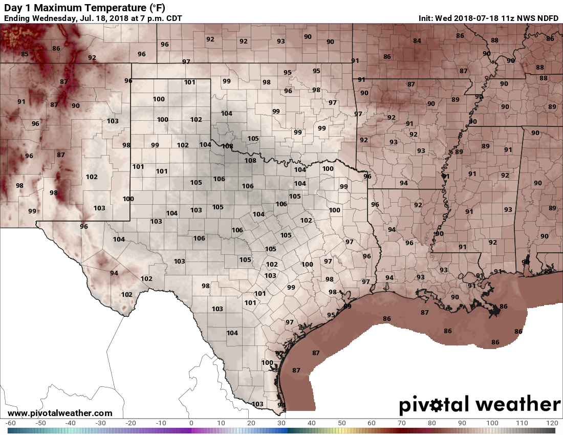
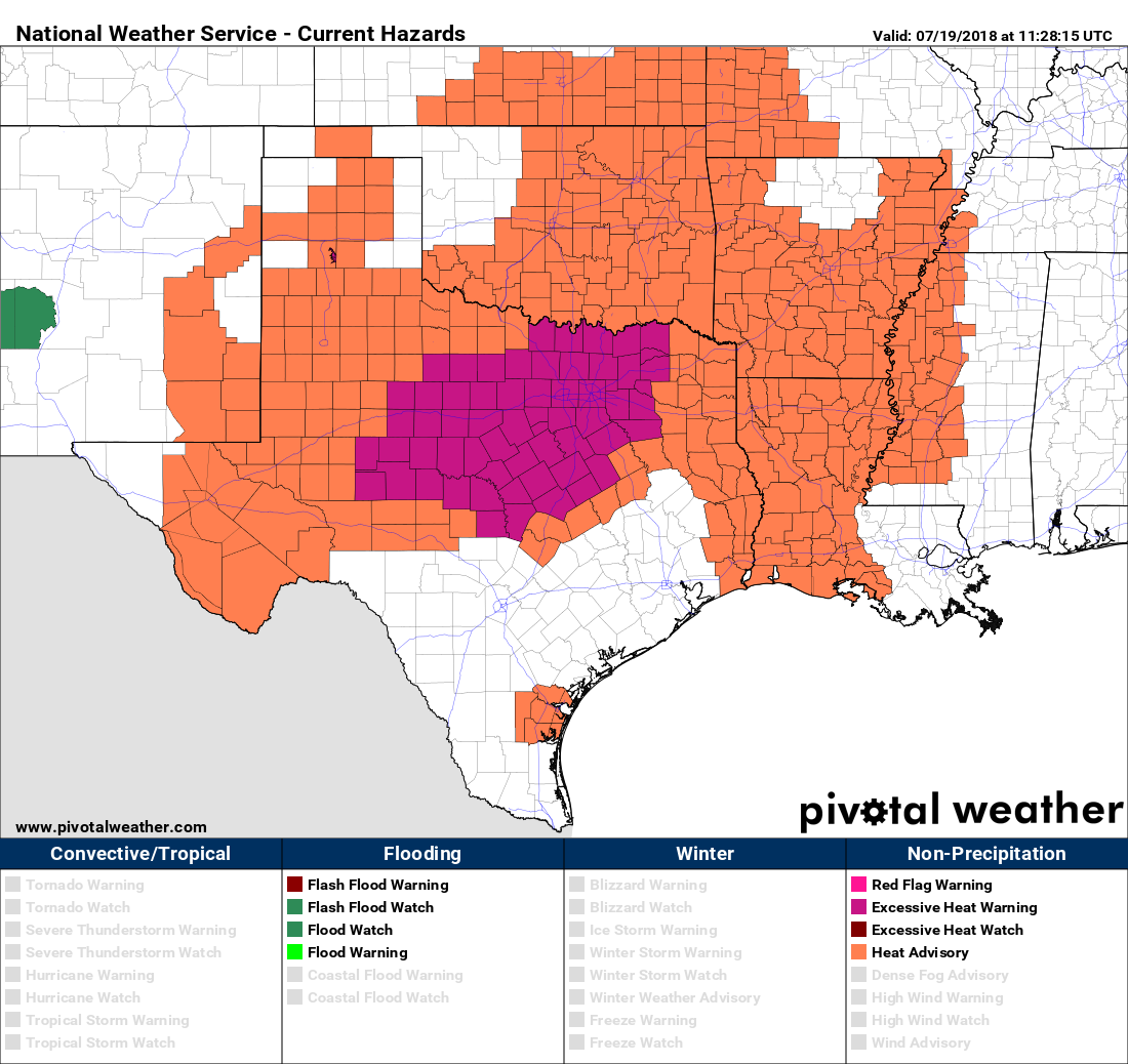
We’ve been talking about the heat this week, and upcoming weekend, for quite a while and unfortunately it will be as bad or worse than expected. The heat is especially extreme in the northern half of Texas, where high temperatures may reach 110 degrees, and areas such as Dallas and Fort Worth will see some of the worst heat since 2011. Heat advisories have been issued for the northern half of Texas, as well as some more extreme heat warnings for DFW and surrounding areas.

Heat advisory (orange) and warning (purple) map for Thursday. (Pivotal Weather)

Additionally, the Electric Reliability Council of Texas, or ERCOT, reported on Wednesday that it set a new, all-time systemwide peak demand record during the afternoon, reaching 72,192 MW between 4 and 5 p.m. Electricity usage will only get higher this weekend as it gets slightly hotter than now, and you can help by conserving electricity (see how at the end of this post).

Thursday

Houston, with its proximity to the Gulf of Mexico, won’t bake quite as much as northern Texas due to high pressures. But it will still be hot and sunny. Expect highs in the upper 90s with lows tonight near 80 degrees.

See full post

As Houston sizzles, how does the rest of hurricane season look?

The forecast remains virtually the same, day by day, for the next week as high pressure dominates our weather. So this post will also take a look at expectations for the rest of the Atlantic hurricane season, which began about seven weeks ago.

Wednesday

Hot, mostly sunny, with highs in the upper 90s. Afternoon heat index values will be 105 degrees or higher, so please take care outside.

Texas will be mighty hot today. (Pivotal Weather)

Thursday, Friday, Saturday, and Sunday

More of the same. I expect high temperatures at one point this weekend will reach 100 degrees. Forecast conditions just won’t change much day by day: Heat, sunshine, no rain, high humidity. This is the Houston we know and love. Right?

Next week

The high heat continues for the first half of next week, but there is a chance the high pressure system will break down during the Wednesday through Friday period, allowing for some decent rain chances to return, and for temperatures to fall back into a slightly more reasonable range. It’s something to hope for.

See full post

Do we actually hit 100 degrees this week in Houston?

Houston last officially recorded a 100-degree temperature on July 29, 2017—hitting 100 degrees right on the nose. This was, in fact, the only 100-degree day during all of last year. Perhaps we will get that lucky again this year with a paucity of very hot days, but some of the higher resolution models indicate the mercury will get to the century mark later this week, perhaps by Friday or Saturday. If this occurs, it should not come as too great of a surprise, as the average first date of Houston’s first 100-degree day is July 24th during the calendar year.

Houston’s 100-degree day climatology. (National Weather Service)

Typically, Houston records about five 100-degree days in a given year, although inland areas (further away from the Gulf waters in the 80s) typically record more, and areas south of Interstate 10 fewer.

Tuesday

Now we come to the actual forecast. Which is pretty easy. Expect sunny and hot conditions, with highs in the upper 90s. Overnight lows will only fall slightly below 80 degrees. The Saharan dust that was so prominent on Monday should begin to fade a bit.

See full post

Welcome to your next 10 days, Houston: Heat and no rain

Houston has had a moderate first half of July, with an average high temperature below 93 degrees, and overall temperatures slightly below normal for this time of year. That is now about to change, as we shift into the mid- and upper-90s, virtually no chance of rain, and full-on summer. We hope you like it hot, because hot is what you’re going to get.

Monday

Remember all those clouds and healthy rain chances last week? Yeah, they’re pretty much gone. During most of last week the amount of moisture in the atmosphere, typically measured as precipitable water, was quite high as we saw values 50 to 100 percent above normal for this time of year. But this morning the tables have turned, with precipitable water values only about 50 to 70 percent of normal levels.

Precipitable water forecast for 7am CT on Monday morning. (Weather Bell)

So rain chances are going to go way down today, and go pretty much away for quite a while. Skies today should be partly sunny with highs in the mid-90s. What you probably will notice is a fine, yellow haze. That’s the Saharan dust that will be with us for the next few days. It will at least make for some pretty sunsets.

See full post