After our drier weather, rain chances return to Houston this weekend

The forecast looks more or less the same for this weekend. We’ll have a dry (very dry for early August, to be honest) start to the day Friday before rain chances pick up through the weekend. If you live up north this is a really pleasant morning for this time of year, with lows as far down as 62 degrees in Crockett, and 65 in much of Montgomery County. Alas, closer to the coast temperatures are still in the mid- to upper-70s due to the influence of the Gulf of Mexico. I’m not sure what more we can expect as this is the dead of summer for us.

Friday’s highs are pretty typical for August in Texas. (Pivotal Weather)

Friday

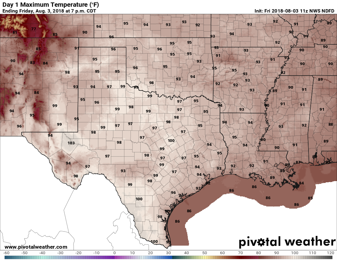
A mostly sunny day, with high temperatures in the mid-90s. We can’t entirely rule out an isolated shower along the coast this afternoon as the sea breeze kicks in, but probably not. As moisture returns, we’re also going to say goodbye to these drier mornings.

See full post

Eight weeks left in the peak of hurricane season for Texas

We’ve now reached August, and for Texas the next eight weeks represent the peak of hurricane season. The good news is that several key indicators, including sea surface temperatures and wind shear, both favor below normal activity for the next two months. Specifically, seas are cooler than normal in the tropical Atlantic where tropical storms and hurricanes most commonly form and then move westward toward the Caribbean Sea and Atlantic Ocean. Additionally, wind shear is forecast to be higher in these regions over the next two months.

Sea surface temperature departure from normal at the end of July. (NOAA)

The only caveat is that seas in the Gulf of Mexico are expected to remain near or above normal. This suggests the greatest threat this year to the Gulf coast will come from a storm that forms relatively near to the shore, and then move inland. We will, of course, be on the lookout for such systems as they don’t provide much warning. For the next week or so, at least, the tropics appear very likely to remain quiet.

Thursday and Friday

After a relatively cool start on Thursday morning, with lows down to around 70 degrees for the northern half of the metro area, there’s not much to say about the weather for the next two days. Highs are likely in the mid-90s, with mostly sunny skies, and lows in the mid- to upper-70s.

See full post

For Houston, a “mild” start to the region’s hottest month

July was not the most pleasant month weather-wise, with four 100-degree days and a lot of sweltering heat during the second half of the month. But it sure ended nicely, with high temperatures in the 80s on Tuesday, with widespread rainfall of 0.5 to 1.5 inches providing some respite for area trees and lawns, and clearing skies in time for sunset. Moreover, the weak front that precipitated the showers left us with drier, cooler weather this morning, with lows in the upper 60s for northern areas of the region.

However, we have now come to August, which means we’ve reached the busiest eight-week stretch of hurricane season for the Texas coast. I’ll have an updated outlook for the season in Thursday’s post, and don’t forget to tune in tonight at 7pm on Facebook Live as I team up with Reliant to talk about hurricane season, summer weather and more. At this time there is no cause for alarm, of course, but it is always a good idea to be prepared along the Gulf coast at this time of year. Now, onto the forecast.

Wednesday and Thursday

For August, conditions will be reasonable in Houston the next two days due to some modestly drier air that accompanied Tuesday’s front. Skies will be mostly sunny, with highs in the mid-90s. But mornings and evenings will be decent, with lows generally into the low- to mid-70s across the region (cooler inland, of course, and warmer near the coast). Along with slightly warmer humidity, this is fine weather for August.

See full post