A few more rainy days before August-like weather returns to Houston

The Houston region will remain in a wetter-than-normal pattern through the weekend before conditions dry out some, and our weather turns more August-like; which is to say hotter and a bit sunnier, without the relief of afternoon showers.
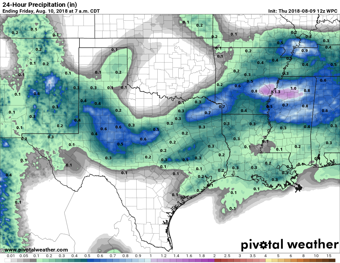
Rain accumulation forecast for Thursday. (Pivotal Weather)

Thursday

Rain chances aren’t ideal today as some drier air has moved into the area, but there still should be activity later this morning and through the afternoon hours scattered across the area. Chances are probably slightly better (40 percent) for the eastern half of Houston versus the western half (30 percent), but at this point we’re splitting hairs. High temperatures today should generally be in the low 90s, although as we saw yesterday it can get hotter in locations where there aren’t a lot of clouds. For example, Wednesday’s high temperature was 96 degrees at Bush Intercontinental Airport.

See full post

Houston cooler, deep tropics quiet. This is an August we can deal with.

Good morning. Houston remains in slightly-cooler-than normal pattern for early August, which is most welcome considering that this typically is the region’s warmest time of year. I don’t see a return to 100-degree days any time soon, but next week does look like it will be a little warmer, with slightly less cloud cover.

Wednesday and Thursday

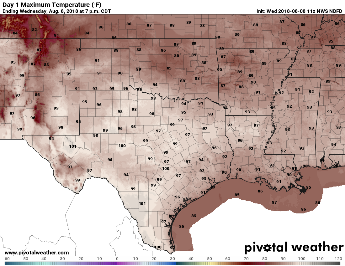
These will be summery days, but with just enough cloud cover to take the edge off of high temperatures. Rain coverage will be lower than we saw on Monday and Tuesday, but there still could be a few showers today streaming in from the coast. Mostly, however, we’ll just see partly sunny skies with highs in the low- to mid-90s on both Wednesday and Thursday. Don’t get me wrong, these will still be hot days, but they should be below the criteria set for heat advisory days, and for August this weather is pretty, uhhh, temperate.

A cool front that will bring highs in the 80s to Oklahoma Wednesday won’t make it all the way to Houston. (Pivotal Weather)

Friday and Saturday

After a cold front stalls north of the Houston region late this week, a couple of upper-level systems may move into the area that should prompt air at the surface to rise, and in turn this will increase our rain chances. This should push the likelihood of rain on both days to about 50 percent—with slightly better odds east of Houston, and slightly worse to the west. High temperatures on Friday and Saturday will depend on the extent of cloud cover and rain. A few areas may stay in the upper 80s, while sunnier locales jump up into the mid-90s.

See full post

Houston to remain in wetter, summertime pattern this week

Houston saw more scattered rather than widespread showers on Monday, and that pattern should more or less hold for most of this week as Houston lies beyond the edge of a high pressure system. This will allow for some areas to see downpours today, and others just sunshine, nearby clouds, and humidity.

Tuesday

Houston will see partly sunny skies today, with highs in the lower 90s. We can expect showers to develop offshore and move inland throughout the day, although again, coverage should be more scattered rather than widespread. Where storms set up, people may see up to about one-half inch of rain fairly quickly, but the storms should move off pretty quickly.

Wednesday and Thursday

Conditions for rainfall become slightly less favorable during the middle of the week, as we may see some capping of the atmosphere. I’d peg rain chances at 20 to 30 percent both of these days, with mostly sunny skies and high temperatures in the low- to mid-90s.

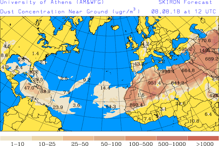
The SKIRON model shows dust backing away from the Texas coast this week. (University of Athens)

We continue to get a lot of questions about African dust. Some of the latest computer models suggest the dust will remain mostly at bay from the central and upper Texas coasts this week—although the dust will remain in place over the Gulf of Mexico—so that shouldn’t be something we have to worry about too much in terms of allergies.

See full post

Houston settles into a wetter, slightly cooler pattern this week

Typically in Houston, early August sees high temperatures in the mid- to upper-90s with full sunshine as high pressure dominates our weather. However, this week Houston will lie on the periphery of high pressure, and this will allow us to see a healthy chance of rain showers this week along the moderately cooler weather. As ever with forecasting rainfall along the Gulf coast, there is a good deal of uncertainty in timing and amounts. But the bottom line is that for August, this week shouldn’t see suffocating heat.

Monday

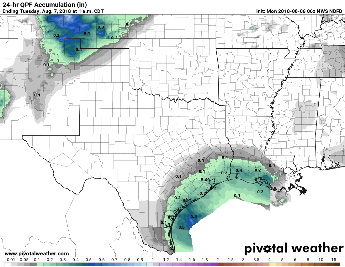
High temperatures today should range from about 90 degrees to the low 90s, depending upon cloud cover and the extent of rainfall. I think most of the area will see one or two tenths of an inch of rain today, with some areas seeing higher amounts in heavier storms. Rain chances will be highest during the afternoon and early evening hours, but I don’t expect any significant disruptions during this evening’s commute.

Rainfall Monday is most likely near the coastal counties. (Pivotal Weather)

Tuesday

Probably more of the same as Monday, albeit with slightly less coverage and temperatures perhaps a tick or two warmer.

See full post