Typical midsummer humidity readying to return for the weekend

We failed to reach a record low temperature yesterday, our last best chance to do that for awhile. But nevertheless, it certainly has been a nice couple days across Southeast Texas. Keep this one in the memory bank to get you to October. Summer will be returning today and tomorrow.

Today

While today won’t be quite as nice as the last couple days, humidity will only slowly return through the day. Look for an outside chance of a shower or two, mainly along the coast this afternoon. Otherwise, expect low-90s today under blue skies and sunshine.

Weekend

Rain chances return this weekend, but not everyone is going to get wet. Look for scattered showers or storms both Saturday and Sunday afternoons as the sea breeze works inland from the coast. If you are lucky enough to see a thunderstorm, you could see as much as a half-inch to an inch of rain perhaps. Most will see less than that, and others still will see nothing at all.

We really could use some rain. Over the last 30 days, unless you live in places like The Woodlands or Spring or Conroe, you’re probably hurting in the rainfall department.
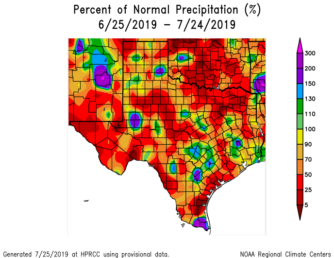
Rainfall across Southeast Texas has been sparse in most areas outside the northern suburbs. (High Plains Regional Climate Center)

In Fort Bend County, for instance, you’ve seen 25 to 50 percent of normal rainfall over the last month. So, it’s no secret that we’re hurting for some rain. As always in Texas, be careful what you wish for, but hopefully some of us will cash in with this weekend’s showers.

Outside of any storms, it will be a partly sunny and hot weekend. High temperatures will hit the low- to mid-90s and low temperatures won’t get much past the mid- to upper-70s.

See full post

Sublime summer weather for another day

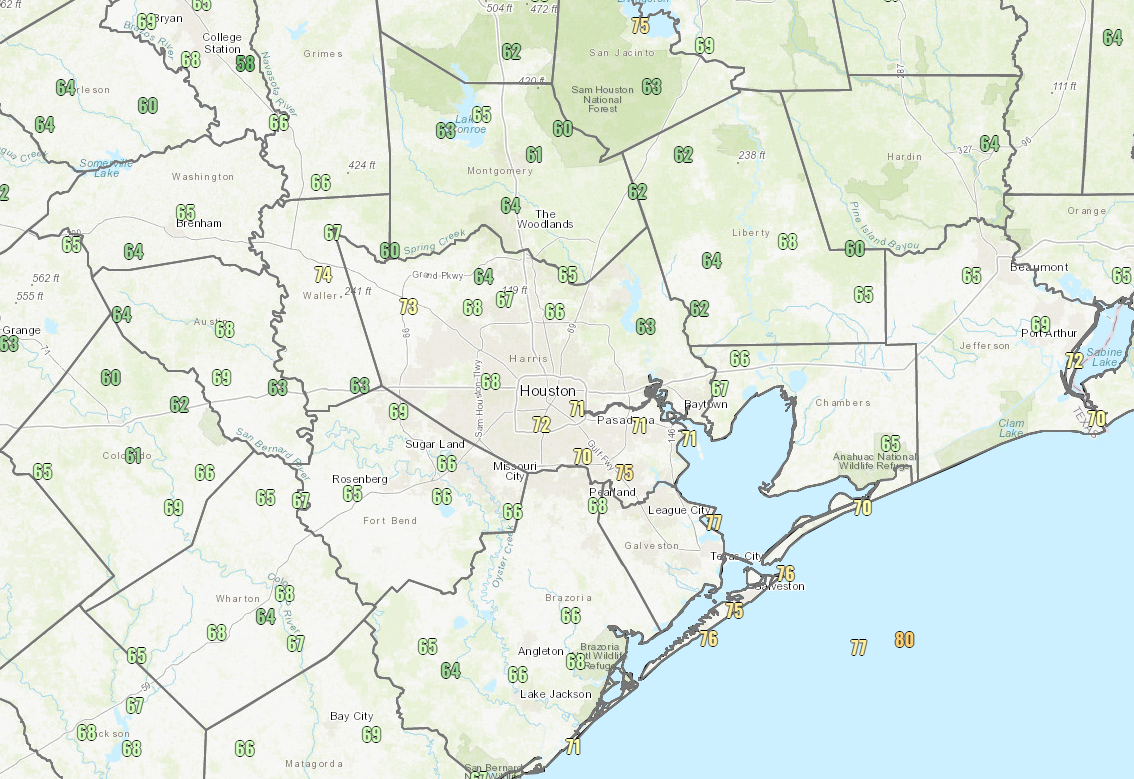
After officially hitting 68° yesterday morning, Houston has outdone itself this morning. We are down to 66° for a low as of this writing. That’s just 1 degree shy of today’s 125 year old daily record low. Unfortunately, we probably won’t get there now, but we made a valiant effort!

Low temperatures as of 6:30 AM Thursday are really impressive and really nice for July. (NOAA)

Widespread 60s were recorded across the area this morning. Closer to the coast, we’ve only been able to muster low- to mid-70s, but it still feels better than it normally would this time of year. The last time it was at least this cool in July was back in 1994, when we managed to hit 64° on the 29th.

Rest of today

Look for beautiful weather today once again. We expect wall to wall sunshine with high temperatures approaching 90 degrees, though with much lower humidity than usual for late-July. Today will be an ozone action day unfortunately; when we get these clear, dry air masses this time of year, it allows ozone to form. So consider air quality today “unhealthy for sensitive groups,” and be sure to take it easy if you need to on days such as this.

Friday

Tomorrow will begin our transition back to high summer. Look for another nice day with ample sunshine, but the humidity will slowly increase. Friday morning won’t be as delightful as the prior couple mornings, but it should still only be in the low-70s here in Houston. Look for mid- or upper-70s at the coast, and a few lucky far inland places may start Friday again in the 60s. Afternoon temperatures should be firmly back into the low 90s.

See full post

Sunny and clear for Houston until the weekend

For July, the weather outside today and tonight will be amazing. Under the influence of gloriously dry air, we’ll see comfortable conditions for the next few days before more summer-like weather returns. We’ll also touch on the tropics in today’s post, although right now we don’t really see anything to worry about.

Wednesday

Temperatures have generally fallen into the low 70s this morning, and despite full sunshine today we don’t expect highs to get much above the upper-80s today. (Normally a mostly sunny day in July would be 5 to 10 degrees warmer). Winds will be out of the northeast at 5 to 10 mph.

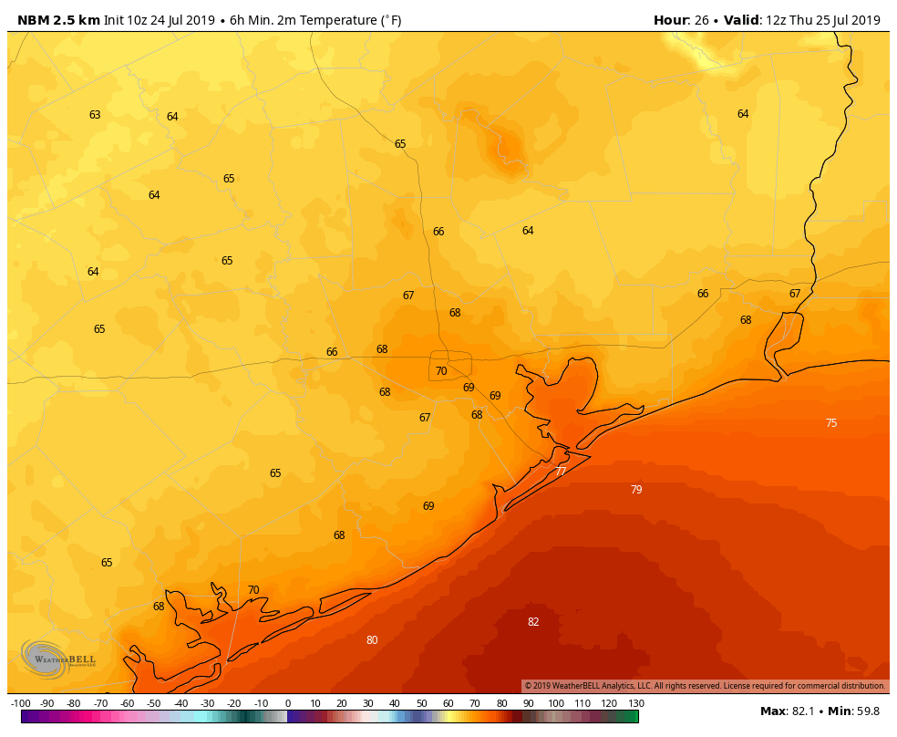
Low temperature forecast for Thursday morning. (Weather Bell)

Under the influence of this northerly flow, dewpoints this afternoon will be in the 40s (to the west) and 50s (in Houston), which will completely obliterate most of our region’s characteristic humidity. Expect very fine weather this evening, with lows in the upper 60s for inland areas. We may approach the record low temperature for July 24, 68 degrees, at Bush Intercontinental Airport, this evening. Don’t miss the fine weather.

Thursday

Another very fine day, a lot like Wednesday, although probably a touch less dry and a touch more humid.

See full post

Houston’s weather will be—dare we say it?—comfortable in July

Pinch yourself, Houston. It’s July. It’s the beginning of the very hottest time of the year. And remarkably, it’s going to feel somewhat dry outside.

A bonafide front pushed through the region during the overnight hours, and into the Gulf of Mexico. Now we aren’t going to see significant cooling during the daytime with this front—the ground is just too warm, the sun is too high in the sky for too long, and there just isn’t that cool of an air mass over the southern United States during the middle of summer. But what we will see is a northerly flow and significantly drier air. You’ll begin to feel this tonight, and it will be pretty amazing for this time of year.

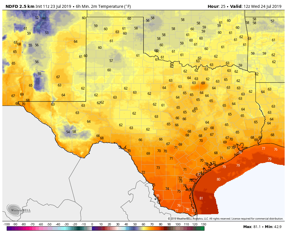
Low temperatures on Wednesday morning for Texas will be something else for July. (Weather Bell)

Tuesday

The front blew through with only scattered showers. The high-resolution models had been trending drier, and the bulk of the storm activity remained offshore. The same models are indicating we may see some brief redevelopment this morning between Interstate 10 and the coast, but after that the atmosphere should really begin to dry out. Highs today will be around 90 degrees with partly to mostly cloudy skies. Skies will clear later today or this evening, and lows should get down to around 70 for most of Houston.

See full post