Late-July tropical Atlantic update: Heating up, but no serious concerns

Tomorrow is the first day of August, which means we are now heading into the peak of hurricane season for the Texas coast through the end of September. It’s a marathon, and it’s important for all of us, residents, public officials, and forecasters alike to pace ourselves through the next few weeks. That’s partially why Eric and I are here, to let you know when a system is worth spending time worrying over. And right now, there’s nothing out there we need to be seriously concerned with.

Tropical outlook in a sentence

We are seeing tropical waves begin to move across the Atlantic with a little more aggressiveness now, and while some systems may develop over the next couple weeks, none at this point is a Gulf concern.

Near-term summary

The tropics have come to life in the last week, with several tropical waves that have at least managed to hold together more respectably than anything we’ve seen since hurricane season began.

The satellite image from this morning across the Tropical Atlantic was definitely a bit active. (College of DuPage)

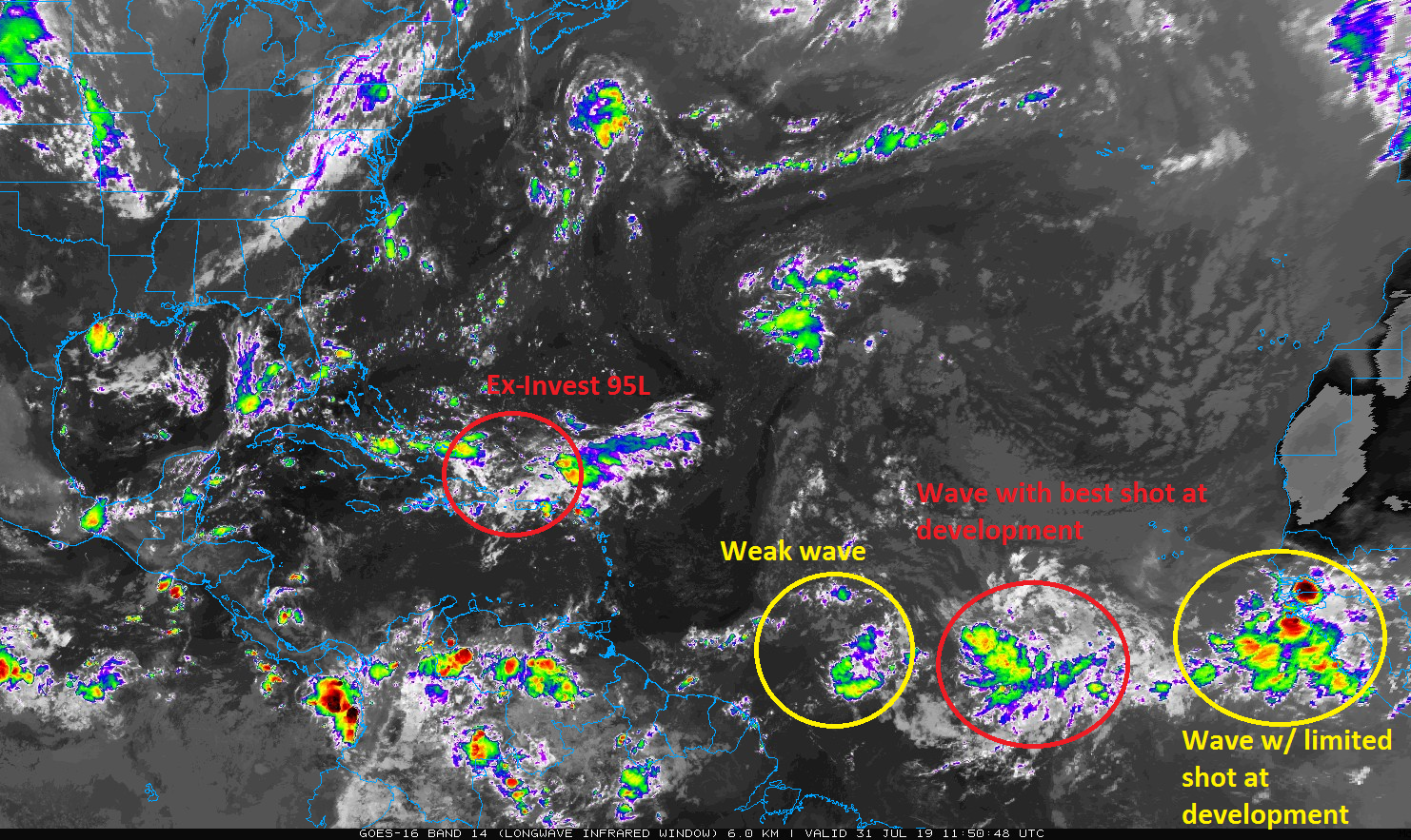
You can see the waves lined up from earlier this morning on the satellite image above. The first one of note is what had been dubbed Invest 95L by the National Hurricane Center (NHC). It’s moving into the Bahamas now. It’s not organized in any meaningful capacity, and I believe it has lost the 95L tag, but the NHC gives it about a 10% chance of doing so over the next few days. Because of another trough digging into the Eastern US, this system will likely get pulled north and northeast toward or east of Florida. At this point, I think this one is a non-issue.

Slightly longer-term outlook

The next wave is about two-thirds of the way to the islands from Africa and is not a concern. Behind it, however, is a rather robust wave that I think has a pretty good shot of development.

The NHC is assigning the tropical wave around 30°W longitude a 50% chance of development this weekend as it approaches the Leeward Islands. (NOAA/NHC)

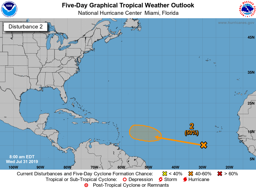
This one will not develop in a day; the hurricane center is giving it a 50 percent chance of development by the weekend just east of the Caribbean islands. Where does it go from there? Read on.

See full post

Fewer storms today, with a mostly dry weekend likely for Houston

While we expected some storms to develop on Tuesday afternoon, we did not quite anticipate how intense they would be—especially on the southeast side of town where frequent lightning lit the sky, and hail fell from it. Some parts of Friendswood and the Clear Lake area picked up 2 to 3 inches of rain in less than two hours. Meanwhile, parts of northwestern Harris County saw zero rainfall for their troubles. Conditions should be more sedate today, with a drying pattern beginning Thursday through most of the weekend.

Wednesday

Rain showers have developed offshore this morning, and the axis for heavier rainfall appears to be about 50 to 100 miles to the south today. While we expect that some storms will migrate inland later today, they are most likely to be confined to counties immediately along the coast, such as Brazoria, Galveston, and Chambers. Areas north of Interstate 10 will probably see 20 percent rain chances, while they increase to 30 to 50 percent along the coast.

This HRRR model snapshot for 2pm CT Wednesday shows the potential for storms to develop near the coast later today. (Weather Bell)

Accumulations should be less than 1 inch for all but a few isolated areas, and storms should pulse downward during the evening hours. Otherwise, expect a warm day, with partly sunny skies and high temperatures in the mid-90s.

Thursday

This should be a more typical summer day in Houston, with a few scattered showers and thunderstorms developing along the sea breeze, during the afternoon, but nothing too organized. Mostly sunny skies with highs in the mid-90s.

See full post

No 100-degree days in Houston this year—yet

As noted Monday, Houston has reached the peak of summer. However, we’ve yet to record any 100-degree days. The highest mark recorded at Bush Intercontinental Airport has been 97 degrees, which the city has reached three times. This isn’t all that abnormal, as we usually see most of our 100-degree days in the coming month or so. But still, it is another indicator that, so far at least, conditions for Houston during the summer of 2019 have been fairly moderate. With that in mind, here is some 100-degree day climatology for the city of Houston:

  • Earliest 100-degree day: June 2, 2011
  • Average first 100-degree day: July 24
  • Average number of 100-degree days: 5-7

It does not appear as though we will see any 100-degree days this week, although we can’t entirely rule that out. Mid-90s are most likely, however.

There will be plenty of 100-degree marks in Texas on Wednesday, but Houston is unlikely to be among them. (Pivotal Weather)

Tuesday

Today will see a pretty healthy chance of storms; with a combination of daytime heating in the mid-90s for most of the region, plenty of atmospheric moisture, and an upper level disturbance sliding into the area this afternoon and evening. High resolution models suggest the better rain potential will be to the east of Interstate 45, but truthfully the entire region will see at least 40 to 50 percent rain chances, especially from about 3pm to 10pm. We probably will see a few bullseyes above 1 inch, with more widespread average of a few tenths of an inch. Lows tonight will be in the upper 70s, with very warm conditions along the coast—Galveston established a record high minimum Monday with a morning low of only 84 degrees, breaking the previous record of 83 degrees set in 2013.

See full post

Welcome to the peak of summer, Houston

Based upon an average of temperatures from 1980 through 2010, which establish so-called “normal” temperatures for the Houston region, the very warmest time of year runs from July 27 through August 20. During this 3.5-week period the average high temperature at Bush Intercontinental Airport is 95 degrees, and the low is 75 degrees. (The comparable period for Hobby is July 22 through August 22). These are the absolute dog days of summer, with hot, humid days, and warm, sultry nights. However, there are some distinct signs that fall is not all that far away, most notably our shortening days—our 13 hour, 37 minute length of day now is nearly 30 minutes shorter than a month ago at the solistice.

Monday

We don’t have great confidence in the forecast for this morning, however we do expect less coverage in showers and thunderstorms than the region saw Sunday, when a few areas south (hello Pearland!) and southeast of the city saw up to 1.5 inches under fairly strong storms. Rain chances today will probably be less than 20 percent, with isolated, mostly short-lived storms. Highs will likely climb into the mid-90s with mostly sunny skies. Lows Monday night will only fall into the upper 70s.

NOAA rain accumulation forecast for now through Wednesday. (Pivotal Weather)

Tuesday and Wednesday

Rain chances will be a little higher on Tuesday and Wednesday, with a bit more of a disturbed upper atmosphere helping to force some lift at the surface. I’d peg rain chances at both days around 40 percent for areas between Interstate 10 and the coast, and 30 percent for inland areas. On average, accumulations will be less than one-half an inch, but there probably will be some outliers that pick up more. Highs in the mid-90s.

See full post