Houston will come close to a freeze on Friday morning

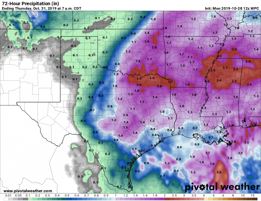
The rains are over for now, but the cold weather is just beginning. Cold air pushing into the Houston region on Thursday will be amplified by gusty winds, especially along the coast. Already this morning, Galveston has recorded a gust of 46mph, while inland areas are generally seeing gusts in the 20s. In terms of temperatures, much of Houston could see record lows on Thursday night.

Thursday

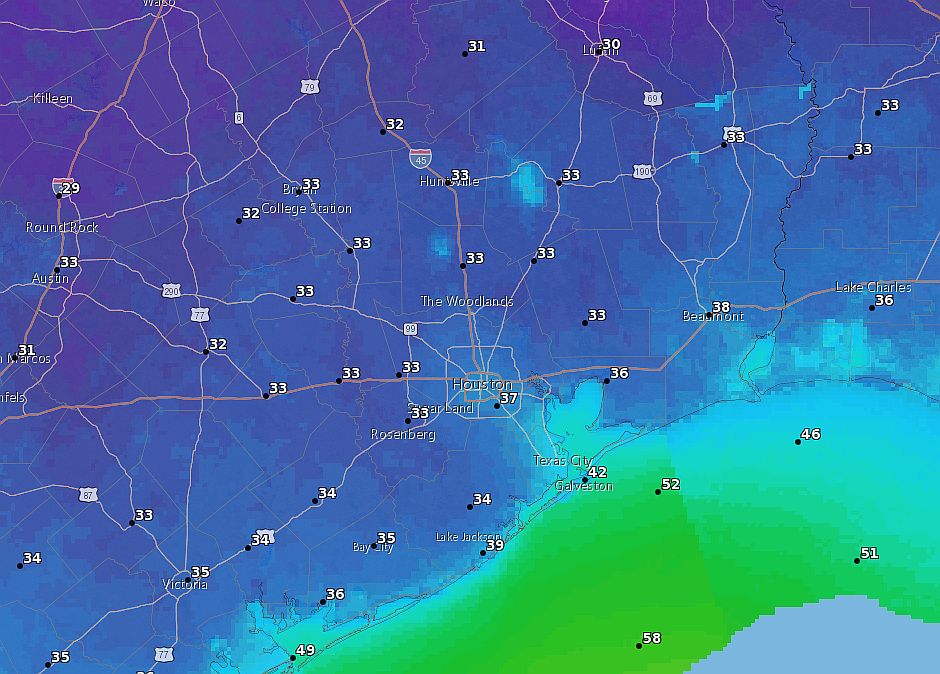
As a deep layer of cold, dry air moves into Houston this morning we are already seeing clearing skies across the region. But despite ample sunshine, high temperatures Thursday will only get into the low- to mid-50s. As a result, this will probably be the coldest Halloween day since 1925. Winds should begin to die down late this afternoon or early evening, about the time when the sun goes down. Temperatures during trick-or-treating, will likely fall into the upper 40s, on their way down to the mid-30s overnight for much of the area. Will it freeze in Houston? Probably not as our relatively wet grounds should help moderate our temperatures just a bit. But it will be pretty close.

Forecast low temperatures for Friday morning. (National Weather Service)

Friday

After a cold and frosty start—Houston’s record low for this date is 35 degrees, and we may tie or beat that—sunshine will help push Friday’s highs up to around 60 degrees. The absence of winds should help this feel quite a bit warmer than Thursday. Low temperatures Friday night, too, should be 5 to 10 degrees warmer than Thursday night.

See full post

Jack Frost is knocking on your door, and he’s not a trick-or-treater

Good morning. A cold front is moving into the western part of Houston this morning, and should push through most of the city this afternoon. The two issues related to the front are rainfall today and tonight, and then very cold air moving in behind the front to end this week.

Wednesday

High temperatures today ahead of the front should reach about 70 degrees for most. This morning a very narrow wedge of cooler air at the surface will push into Houston, and this will filter through the region. For the most part, rain showers during the daytime hours appear likely to be fast moving, and relatively brief—right now we do not anticipate the very heavy, organized rain we saw Tuesday in locations such as Tomball and The Woodlands. However, since that rainfall was not well forecast I do not have particularly high confidence in rain forecasts for the next 24 hours.

Temperature forecast for 5pm Wednesday. (Weather Bell)

Wednesday night

The rest of the front, meaning a much deeper mass of colder air from higher up in the atmosphere, will push through Houston tonight, and this will drive the potential for some heavier rain, most likely between about 10pm Wednesday and 6am Thursday, moving from inland areas toward the coast. Again, these showers shouldn’t last too long, but some areas may have the potential for 1-3 inches. (Most of Houston will likely see less than 1 inch of rain). Temperatures Wednesday night will get down to around 40 degrees for most locations.

See full post

After seven months, winter-like weather returns to Houston

Houston’s low temperature last touched the 30s back on April 2nd, the last gasp of winter. After that, the region’s nighttime temperatures never got below the mid-40s again, and then summer came to town. Now, it appears as though much of Houston may briefly slip into the upper 30s at the end of this week, and daytime highs will feel more like mid-winter than fall.

Tuesday

Conditions today will be mostly cloudy, fairly muggy, with intermittent light rain. A cold front will get past the Interstate 35 corridor in central Texas, but stop well short of the Houston area. This means that we should have relatively mild weather today and tonight—if your plans involve a certain baseball team and much-hoped for revelry there is good news. It appears likely that any daytime or early evening showers should wane by 9 or 10pm tonight. Temperatures likely will not fall below 70 degrees Tuesday night.

Severe weather outlook for Wednesday and Wednesday night. (NOAA)

Wednesday

It’s cold front day! Atmospheric dynamics over the central United States will essentially shove the front toward the coast on Wednesday. What time will it move through Houston? Great question. Our best guess is that it pushes through Houston during the late afternoon hours and off the coast shortly after sunset, but confidence in the exact timing is low. Basically, we can expect conditions to get fairly warm on Wednesday ahead of the front—upper 70s?—and quite cold and breezy in its wake.

Rain accumulation forecast for now through Thursday. (Pivotal Weather)

The other story to follow will be rainfall, and most of this should come during a period from Wednesday after noon through early Thursday. I think much of the region will probably get 0.5 to 1.5 inches, but there could be some outliers that pick up as much as 3 inches. Still, we do not have a real high concern for even street flooding at this time. Whenever the front passes through, there will be the threat of strong winds and light hail. So if there is a Game 7 of the World Series, we may have some concerns about weather going into, or coming home from the game. Hopefully a win tonight obviates these concerns.

See full post

Halloween forecast coming into focus—Mother Nature is coming as a cold front

I hope everyone enjoyed that incredible weekend, as our weather this week will involve a number of tricks to go along with a few treats. What we are increasingly confident of is that conditions will probably dry out before Thursday afternoon or evening, with the most likely scenario of cool, breezy, and dry weather for trick-or-treating. Warm costumes are recommended for the kids.

Monday

The onshore flow has kicked into gear, but today should still be a pretty nice one across the Houston area, with partly to mostly sunny skies, and highs holding to around 80 degrees. Increasing moisture levels will lead to a fairly cloudy night, and as a result low temperatures tonight will not fall much below 70 degrees for most of the metro area.

NOAA rain accumulation forecast for now through Thursday morning. (Pivotal Weather)

Tuesday and Wednesday

As the amount of moisture in the atmosphere rises, we’ll see a corresponding increase in rain chances on Tuesday and Wednesday ahead of the next cold front. Rain chances on Tuesday will be fairly high, without about two-thirds of the area probably seeing light showers. If you’re heading to the Astros game Tuesday evening, however, we think any daytime rainfall will probably wane by or before game time. Post-game temperatures will be around 70 degrees.

The heavier rainfall will hold off until Wednesday—most likely during the afternoon or overnight hours. In terms of accumulation, we can probably expect between 0.5 to 1.5 inches for most areas through Thursday morning, although we cannot rule out greater accumulations. Highs both days will be around 80 degrees. Let’s hope the Astros wrap the series up Tuesday, because Wednesday evening could definitely a bit wet for any revelry.

See full post