Good morning. A cold front is moving into the western part of Houston this morning, and should push through most of the city this afternoon. The two issues related to the front are rainfall today and tonight, and then very cold air moving in behind the front to end this week.
Wednesday
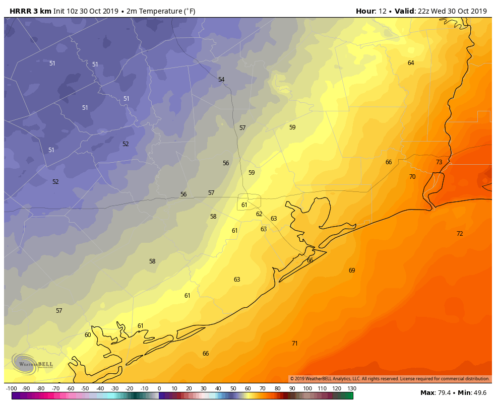
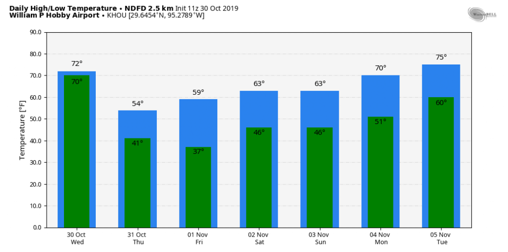
High temperatures today ahead of the front should reach about 70 degrees for most. This morning a very narrow wedge of cooler air at the surface will push into Houston, and this will filter through the region. For the most part, rain showers during the daytime hours appear likely to be fast moving, and relatively brief—right now we do not anticipate the very heavy, organized rain we saw Tuesday in locations such as Tomball and The Woodlands. However, since that rainfall was not well forecast I do not have particularly high confidence in rain forecasts for the next 24 hours.
Wednesday night
The rest of the front, meaning a much deeper mass of colder air from higher up in the atmosphere, will push through Houston tonight, and this will drive the potential for some heavier rain, most likely between about 10pm Wednesday and 6am Thursday, moving from inland areas toward the coast. Again, these showers shouldn’t last too long, but some areas may have the potential for 1-3 inches. (Most of Houston will likely see less than 1 inch of rain). Temperatures Wednesday night will get down to around 40 degrees for most locations.

Thursday
Halloween is going to be a howler. Rains should end by or before sunset, and clouds should dissipate some time in the late morning or early afternoon. But it will be breezy, with wind gusts above 20 to 25 mph as a much colder and drier air mass blows into Houston. (There is a gale warning for coastal waters). Despite the sunshine, highs on Thursday will only reach the low- to mid-50s, so for many trick-or-treaters the temperatures will already be in the upper 40s by early evening. Bundle those kids up.
Thursday night
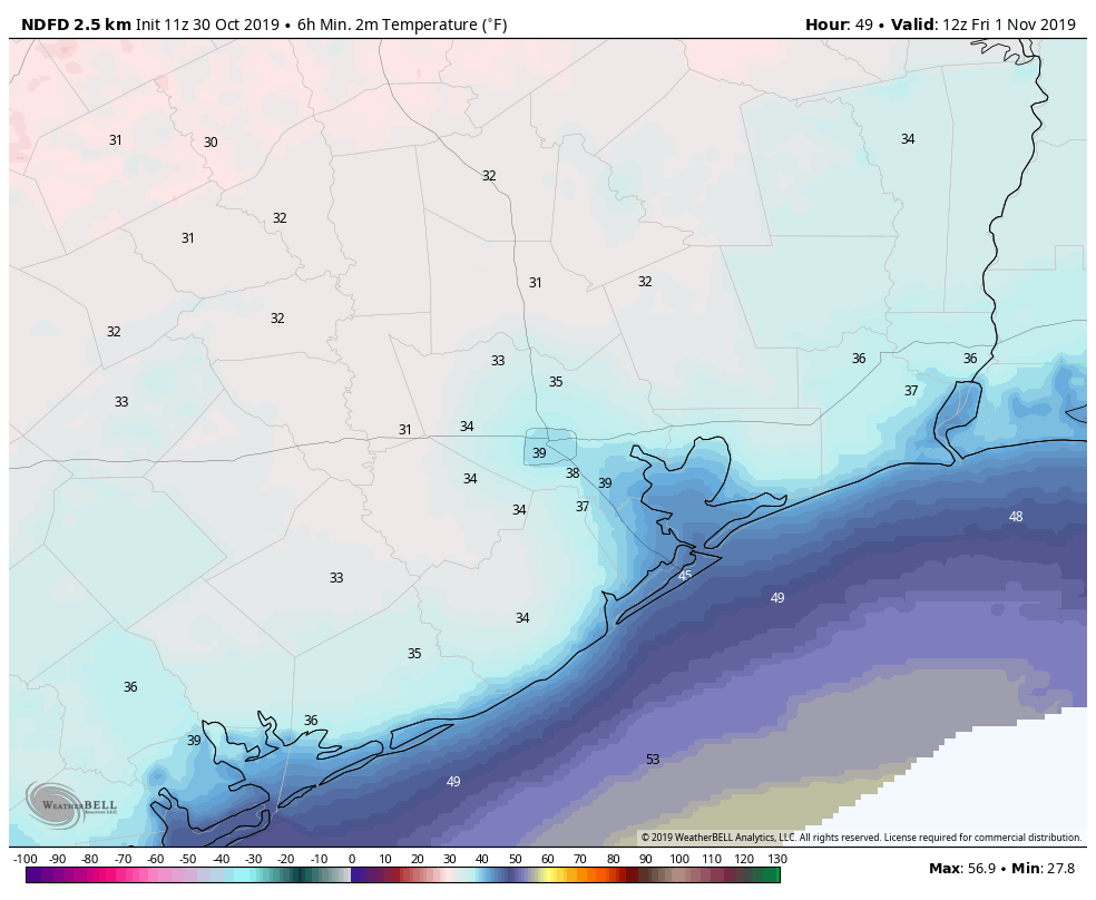
The temperature forecast continues to trend colder for Thursday night, with the possibility of a freeze in places like Waller and Montgomery counties. Most of Houston should stay in the mid- to upper-30s, but places like Huntsville, College Station, and elsewhere could record their first freeze a few weeks earlier than normal.
Friday and Saturday
These should be cool days, with highs of around 60 degrees, and partly to mostly sunny skies. Overnight lows will probably be a few degrees warmer, likely in the low 40s for most of Houston, but there’s some uncertainty in that with a reinforcing front possible.
Sunday
Perhaps a shade warmer than Saturday, but still cool for this time of year with highs in the 60s. Partly sunny skies.
Next week
Beginning Monday the onshore flow returns, and after this we will probably see highs returning to the 70s, with lows rebounding into the 60s. With the return of clouds rain chances will jump up too, but we’re not tracking any aggressive storm systems.
Halloween is going to be a Howler…I love it!
Only you guys can come up with such puns so early in the morning!
Any word on wind chill factors on Thursday? I know it’s not a regular part of most Houston forecasts, but the numbers you propose suggest it might be significant.
Check out this page. The blue line on the first graph is the wind chill factor
How is visibility going to be the next couple of nights? Drizzle, low clouds and just darkness coming earlier than we’ve had for 6 months adds up to folks driving crazy. With tons of folks out and about tonight for Game 7, and then tomorrow for Halloween, it would help matters if we had a bit of clear weather to drive around in the dark.
For Thursday, “Rains should end by or before sunset, and clouds should dissipate some time in the late morning or early afternoon.” Did you mean “by or before sunrise”?
That gave me pause as well but I think they mean will end by or before sunset today and clouds dissipate by late morning or afternoon tomorrow.
Yeah, I think he has to mean before sunrise Thursday since he is forecasting the heavier rains to commence around 10 p.m. tonight [Wednesday].
National Weather Service says that rain should end by 6AM Thursday morning.
According to the Harris County Flood Control District, water levels have risen higher than the top of the spillway and “flooding near site is likely”.
https://www.harriscountyfws.org/GageDetail/Index/750
Hopefully there will not be much additional rain in the near future.
The Lake Houston Dam spillway, that is…
What no words to support the Astros for tonight’s game?? Go Astros… you can do it!!!
Seconded. Go Stros!!!!
I am curious: what is causing this early surge of winter down here? Anchorage, for instance, doesn’t seem particularly cold (highs in the 40s).
the bayou was nearly full yesterday I guess from the rain in the north. The winds are annoying and downright awful. We start the season of astronomical gas bills early
At least natural gas is cheap these days.
So will be as cold as the Astros bats with RISP?
It’s about freakin’ time we got a good front in. Air conditioner was running again last night. In late October.
Last weekend alternated between the A/C running some days and the furnace running in the morning on others. It’s about as crazy as this Daylight Savings Time stuff we put ourselves through twice a year.
Oh my my my what difficult times we face here in Katy TX. First my Astros are cheated out of celebrating another sovereign championship. Now we must take it back under freezing conditions. The fire is literally being stoaked day and night in Katy TX. My skin is dry and I just can’t stand this wicked day approaching. Some of the only good news is my two favorite holidays are right around the corner. Praying we can still get back up to the 90s a few more times in the coming weeks. Go Stros!
Why do you want it to be in the 90s again? Please no!