Tuesday offers a taste of cooler weather for the weekend

Good morning. It seemed to take forever, but a genuine cold front did drag into Houston on Monday. As the sun dropped, so did temperatures, with overnight lows ranging from about 60 degrees in northern areas such as Huntsville to around 70 degrees along the coast. It’s not cold, per se, but it’s cooler than we’ve been and the air is noticeably drier. A stronger front will follow to set us up for a beautiful fall weekend.

Tuesday

Skies should clear out later this morning, leading to a mostly sunny afternoon across the area. Highs will be in the low- to mid-80s, with a continuing light northerly wind. This evening should be splendid, with overnight temperatures Tuesday night perhaps a degree or two cooler than Monday night.
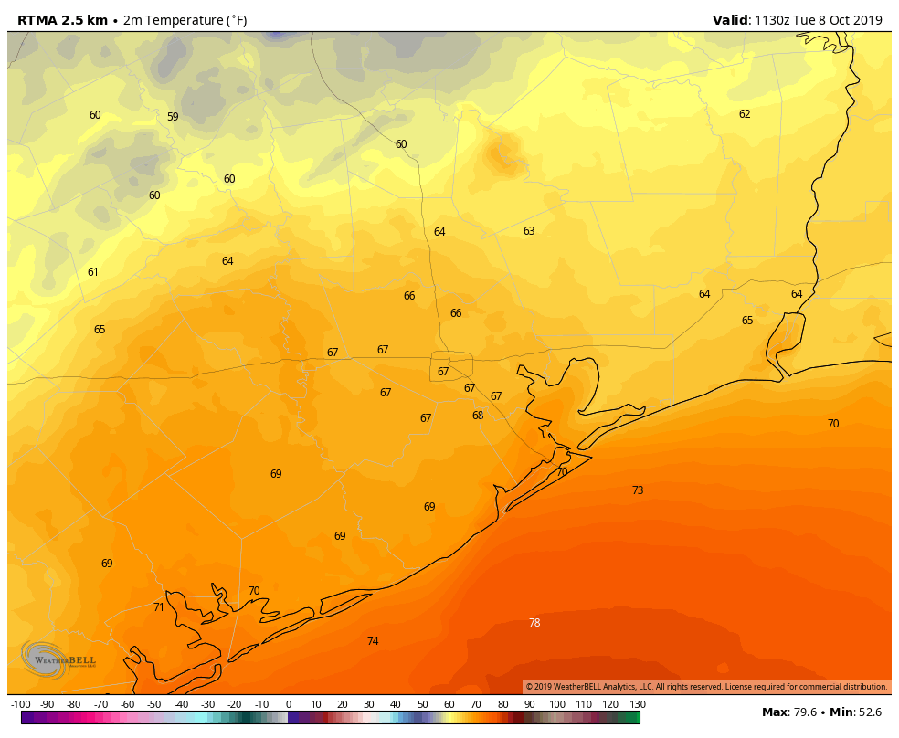
Temperatures on Tuesday morning are cooler, but certainly not cold. (Weather Bell)

Wednesday

By Wednesday morning, we’re going to begin transitioning back toward warmer, somewhat more humid weather as the onshore flow resumes. It won’t be unpleasant, for sure, but high temperatures should climb into the mid- or (more likely) upper-80s under sunny skies. Overnight lows will struggle to fall below 75 for much of the area.

Thursday

Briefly, we’re going to return to the summer-like weather we experienced for most of September and the first six days of October. Look for highs of around 90 degrees with another warm and humid night, under mostly sunny skies.

See full post

Happy Fall Day, Houston—you’ve earned it

After a dreadful September that entailed a devastating tropical storm, 100-degree heat, and unending humidity, the season’s first fall front dragged into Houston on Monday. It’s not super strong, but after nearly five months of summer-like weather it will be strong enough. And with the promise of more cool fronts on the way, we are well and truly entering fall.

Monday

The first six days of October have produced an average temperature of 82.6 degrees, which is 7.7 degrees warmer than normal. Today’s high temperature may not even reach 82.6 degrees as a mix of drier and cooler air move into Houston. As the front blows in, winds could gust up as high as 20mph this afternoon.

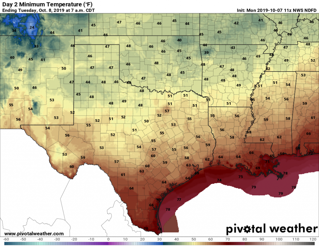
Tonight should be especially sublime as drier air at sunset will push low temperatures into the 60s this evening—a wonderful time for a walk or whatever outdoors. Low temperatures by Tuesday morning should drop into the upper-50s for inland areas, and low 60s for most of the rest of Houston. It’s all nice enough that we’re declaring today to be our annual Fall Day holiday.

Low temperatures for Monday night into Tuesday morning. (Pivotal Weather)

Tuesday

This should be a great early fall day, with sunny skies, highs in the low- to mid-80s, and overnight lows a couple a degrees warmer than Monday night.

Wednesday and Thursday

Warmer conditions return to Houston as the onshore flow resumes. Highs will creep back into the upper 80s, and unfortunately nighttime temperatures are going back into the 70s. Skies should be mostly sunny.

See full post

Double your pleasure, double your fun; double cool fronts, coming for Houston

Three more days until the heat and humidity breaks. Yes, really.

Friday

It is warm and muggy this morning, and ultimately conditions will be a lot like they were on Thursday. We saw some scattered, late-evening storms fire up just north of Interstate 10 on Thursday, and we may seem a similar pattern on Friday as the sea breeze moves inland—these should be fast moving and not produce too much in the way of rainfall. High temperatures will likely reach the low 90s for most of the area with sunny skies.

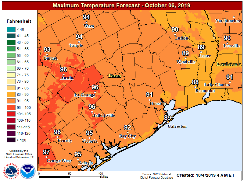
High temperatures on Saturday will be hot, especially for central Texas. (National Weather Service)

Saturday

Did you read Friday’s forecast? Because Saturday will be similar, albeit probably with even less rain shower coverage. Mid-90s will be possible for areas just west of metro Houston.

Sunday

Another warm and sunny day, with highs of around 90 degrees for most of the region. If you’re heading to the Texans game, there will be no issues except for the heat. Because the cold front is unlikely before Sunday night, this will be another summer-like day. But this will be the last one before a much anticipated break.

See full post

Yes, fall really is finally on the way for Houston

After an oh-so-very-long summer we are continuing to make progress toward fall in the Houston area. The region’s cold front remains on track for Monday, and the only question at this time appears to be how strong it will be. Looking a bit further ahead, a second front appears likely by the end of next week, signalling that we truly are moving into a fall-like pattern.

Thursday

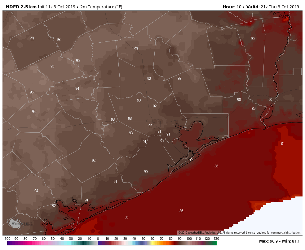
Alas, summer will hold on for a while longer. Thursday should be mostly hot and sunny with high temperatures in the low 90s. We can’t entirely rule out some isolated to scattered showers, but most of the region will indeed be dry. It’s going to be another muggy night, where most of the region fails to drop out of the upper 70s. Yeah, we’re tired of those kinds of nights, too.

Summer will rage on today, with highs in the 90s. (Weather Bell)

Friday

A similar story will play out on Friday, although rain chances may step up to about 20 percent by the evening hours as a cold front stalls out well north of Houston. Look for high temperatures again in the low 90s.

Saturday and Sunday

It should be a hot and mostly sunny weekend for the Houston metro area. On the plus side, if you were looking for one more really warm beach or pool weekend—and the last 4,382 this summer haven’t been enough—you’re in luck. It’s going to be warm, with highs generally in the 90 to 93-degree range. Nights may be a shade cooler than we’ve seen, with some slightly drier air backing into the region. Rain chances will be near zero until Sunday night.

See full post