Stellar weekend ahead, but no cold turkey this Thanksgiving

Brace your sinuses: We will be dealing with some ups and downs over the next 7 to 10 days. We’re about to end one of the “ups” and head into a brief “down” period this weekend, but if you have weekend plans, it looks delightful. As for the forthcoming holiday weekend? I’ll be spinning the wheel of discontent to determine what to forecast for you. Read on.

Today

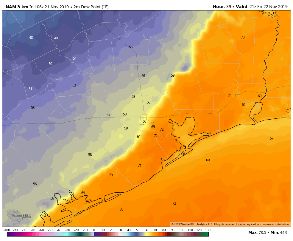
We’ve seen a few showers pop up this morning across the region. As I write this, some heavier downpours are ongoing from near the Galleria into Spring Branch, lifting quickly southwest to northeast. That will be the story today: A lot of clouds and occasional showers. A thunderstorm will also be possible, especially as the cold front pushes across the area late this morning and early this afternoon.

The cold front is shown as darker blue line in this forecast depiction from the HRRR model for 1 PM today (Weather Bell)

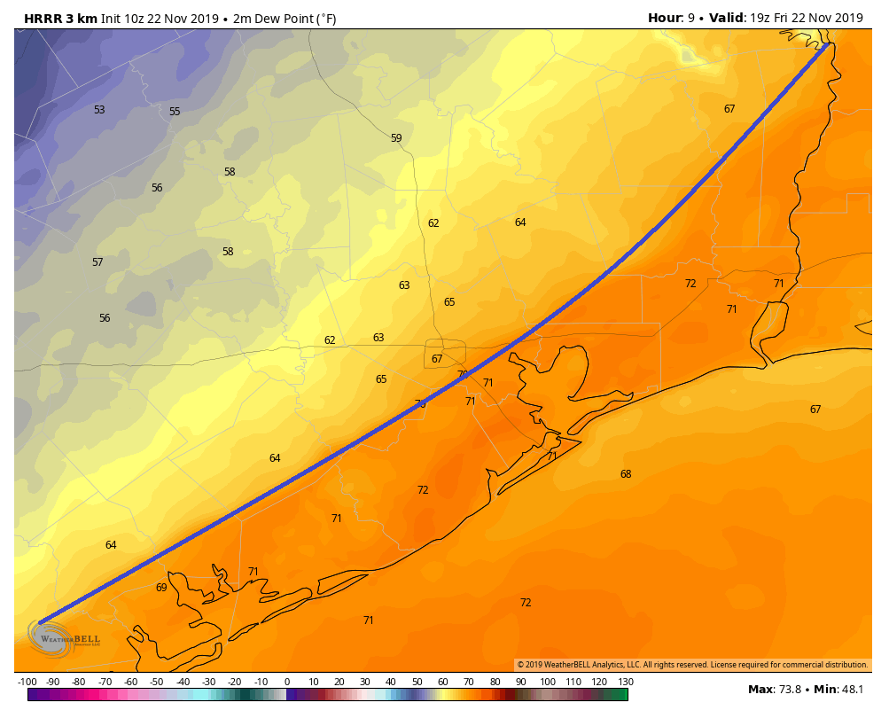
The HRRR model above depicts the front just southeast of Downtown Houston by 1 PM this afternoon. So look for the front to pass through the region between 11 AM and 3 PM before moving offshore. The temperature drop immediately behind the front will not be too impressive, but it will be noticeable. Look for temps to peak around late morning or Noon in the mid- to upper-70s. We’ll drop into the mid- to upper-60s an hour or two after the front passes by.

Weekend

Both Saturday and Sunday look splendid. Sunshine should dominate, punctuated by a few high clouds. High temperatures will get into the mid- to upper-60s.

Saturday morning’s NWS forecast low temperatures show 40s across much of the area. (Pivotal Weather)

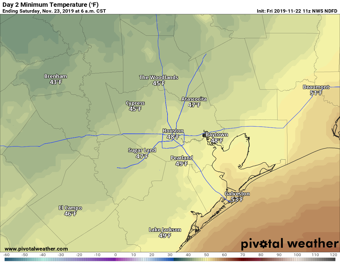
Lows tomorrow morning should be in the 40s just about everywhere away from the coast. Sunday morning should bottom out similarly in the 40s to low-50s.

See full post

We do not relish the changing Thanksgiving forecast for Houston

Houston temperatures have steadily been on an upswing for the last 10 days, climbing from the 40s for three days, into the 60s, the 70s, and finally on Wednesday reaching 80 degrees at Bush Intercontinental Airport. Despite the warming trend, temperatures this month are still running nearly 8 degrees below normal for November. We’ll have another warm day, plus some of Friday, before a decently strong front arrives to bring chilly weather back.

Houston’s temperatures have been climbing for the last nine days. (National Weather Service)

Thursday

Conditions today should be similar to Wednesday, albeit with more clouds and a little wind. Even with mostly gray skies, temperatures today should push into the upper 70s to possibly 80 degrees with plenty of humidity. Some scattered, mostly light showers may move through the region today from the southwest, but any heavier rain should wait until Friday’s front. Low temperatures tonight may not fall below 70 for some parts of the metro area.

This NAM model forecast for dewpoints shows the cold front’s position by 3pm Friday. (Weather Bell)

Friday

The first half of Friday will keep the warm, humid trend going ahead of the cold front. This should arrive in northwest Harris County some time around noon or shortly after, and push through the metro area before sunset. Rain accumulations look to be modest, with one-quarter to one-half inch west of Interstate 45, and perhaps a little more than one-half inch to the east. In any case, we should see gradually clearing skies on Friday night as temperatures fall to around 50 degrees for most of Houston.

See full post

South winds blow today, increasing moisture for Friday’s front

Good morning! Our forecast for the week ahead remains more or less on track. We’ll continue to see warm, mild weather into Friday, at which point a front will cool us down for the weekend. Another front should arrive a day or two before Thanksgiving, but we still have some questions about the holiday’s weather.

Wednesday

Some parts of the region are seeing fog this morning, but it should burn off fairly quickly. Any sunshine this morning will likely be fleeting as clouds build over the area today. We should really start to feel the onshore flow as winds gust into the 20s, increasing moisture levels in the atmosphere. This may result in a very few, very scattered showers today, but for the most part the better rain chances will hold off until Friday. Highs will get into the upper 70s for the most part, and lows tonight won’t drop much below 70 degrees.

Thursday

Did you like the forecast for Wednesday? Because as of now conditions will probably be similar on Thursday, although the onshore winds will not be quite as blowy. Is blowy a word? Well, we’re using it this morning.

NOAA Rain accumulation forecast through Friday. (Pivotal Weather)

Friday

Rain chances will perk up on Friday with the arrival of the aforementioned cold front. An upper-level storm system will propel the front across the region, likely just before sunset for the central part of the region, and offshore by or shortly after sunset. It’s not an overly potent upper-level system, but it will provide enough lift to put our relatively moist atmosphere to work producing perhaps 0.25 to 1.0 inch of rain. The rains should end relatively soon after the front passes, with lows falling to around 50 degrees on Friday night.

See full post

Looks like another stellar fall weekend lies ahead for Houston

We’re seeing some fog over central and southern parts of the region, but that should burn off this morning. Houston will then have four days in the 70s before cooler, and sunny weather arrives for this weekend. Yes, it looks like we’ll have another stunning, clear and crisp Saturday and Sunday for you in the Bayou City.

Tuesday

If you like sunshine, soak it up today, because most of the rest of the work week will be cloudy. But for Tuesday, we should see plenty of sunshine, with highs in the mid-70s. Partially to mostly clear skies should allow low temperatures to fall to around 60 degrees on Tuesday night. So yeah, today should be really quite nice.

Wednesday and Thursday

Humidity and cloud cover returns for the middle of the week, as onshore winds get flowing. High temperatures both days should be in the mid- to upper-70s, depending on how much (if any) sunshine peeks through the afternoon clouds. Some very light rain will be possible beginning Wednesday night into Thursday, especially to the west of Interstate 45. But accumulations will be slight. With mostly cloudy skies, expect lows to only drop into the mid-60s both nights.

NOAA rain accumulation forecast for now through Saturday. (Pivotal Weather)

Friday

Confidence is increasing in our next cold front pushing through on Friday, perhaps later in the day, or late evening hours. Forecast models aren’t overly bullish on rainfall totals, which probably will end up in the 0.25 to 0.75 inch range. Highs Friday will depend on the frontal timing, but we can probably safely expect them to top out somewhere in the mid-70s.

See full post