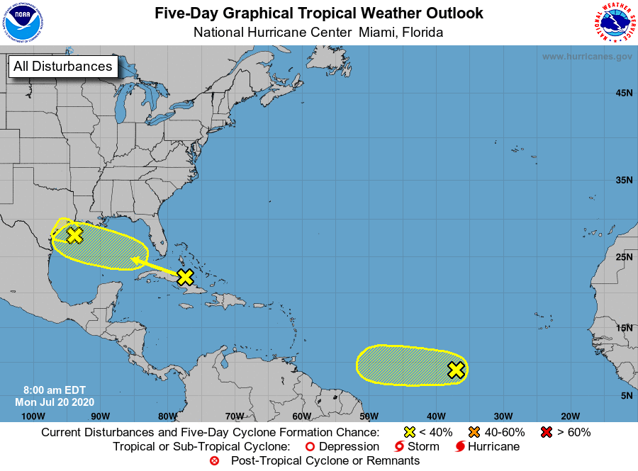
Good morning! After its first 19 days, this month was on pace to become Houston’s warmest July ever on record, besting 1980 by nearly 1 full degree. However, with cooler weather ahead this week due to clouds and rainfall, we should back off those temperatures somewhat. Indeed, the story for the next week will be rainfall and tropical moisture, with two tropical waves headed this way.
Two tropical waves will affect Texas this week. Neither pose an overwhelming concern, however. (National Hurricane Center)
Monday
The first of two tropical waves lies just off the Texas coast, and will push inland today and Tuesday. (Note: The National Hurricane Center has given this system a 10 percent chance of forming into a tropical depression). As this moisture moves inland, we’re likely to see a greater than 50 percent chance of rain for coastal counties, and a less than 50 percent chance of rain for inland counties. Overall accumulations should be on the lower side Monday, with most areas likely seeing one-half inch of rain, or less. Clouds will help limit temperatures in the low 90s, with overnight lows in the upper 70s.
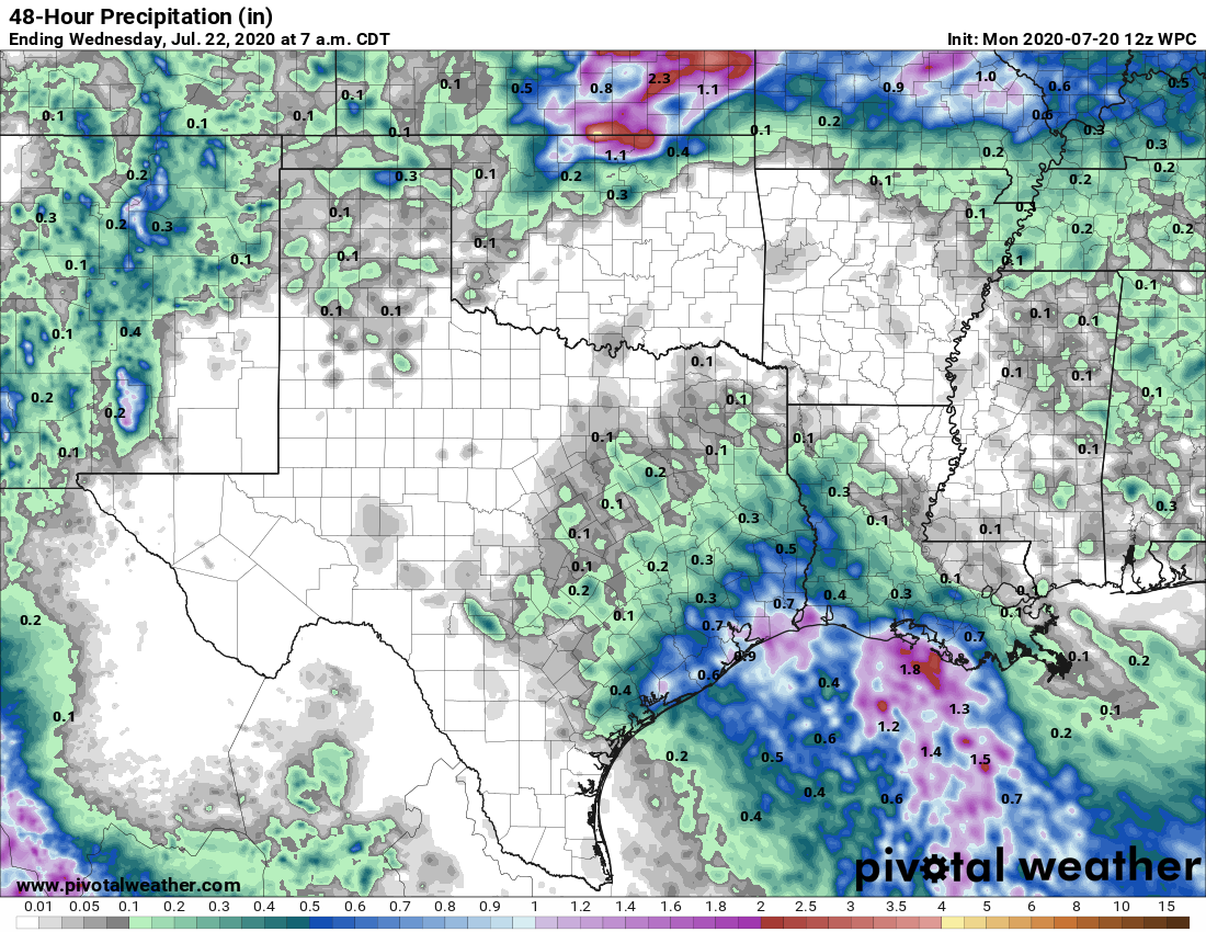
NOAA rain accumulation forecast for now through Tuesday. (Pivotal Weather)
Tuesday
By Tuesday, as the bulk of the tropical wave moves onshore, much of the area should see a healthy chance of rain showers, well above 50 percent. Accumulations for most people should be about one-half inch of rain, but due to the tropical nature of this moisture, we probably will see some bullseyes that produce up a few inches of rainfall fairly quickly. With cloudy skies and showers, high temperatures should be limited to about 90 degrees.
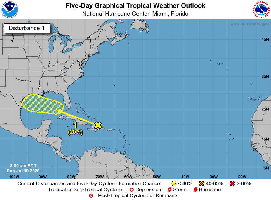
As expected this weekend, the Houston region has transitioned from a hot and sunny pattern that dominated the first half of July into one with more clouds, higher rain chances, and slightly cooler temperatures. That trend will continue this week. So why are we posting on a Sunday? Because a tropical system may approach Texas late this week.
This morning the National Hurricane Center called attention to the possibility that this system will develop into a tropical depression or storm, giving it a 20 percent chance of doing so by Friday.
A tropical disturbance may move into the Gulf this week. (National Hurricane Center)
This may sound scary, but right now this is not a feature we’re overly concerned about. While it is possible that this disturbance develops into a weak tropical storm, there appears to be only a little support for this scenario in the global models, and no indication whatsoever of anything stronger than that. So as is often the case with tropical systems in June and July, the biggest worry is heavy rainfall. That’s possible on Friday and Saturday, but again there is no particularly strong signal for extensive heavy rainfall in the global models.
The bottom line: We’re tracking the movement of a tropical system that will push into the Gulf of Mexico this week, and should head toward Texas. There is, for now, no evidence of any particularly extreme weather—perhaps we will see a few inches of rainfall and some elevated winds. We will of course continue to watch it closely.
It feels like it has been eons, but the last time it rained in the Houston area with any meaning was back on July 7th, or only about 10 days ago. Today will be our best chance since then at seeing some showers. Fortunately, we don’t foresee rain chances truly dropping to zero again anytime soon, but they will wax and wane as some features shuffle around the Gulf Coast. Let’s take a look.
Today
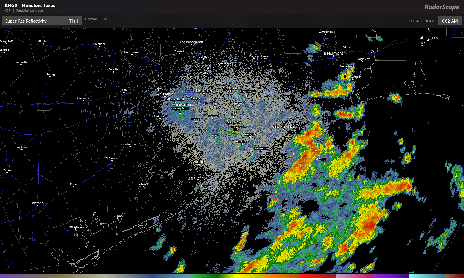
We have a weak disturbance coming at us today from Louisiana, and that will provide the impetus for scattered showers and thunderstorms, especially south and east of Houston. Radar is already lighting up this morning off the coast.
Showers and thunderstorms are numerous over the Gulf early this morning, and those will work toward coastal areas over the next few hours. (RadarScope)
Look for these offshore showers and storms to move onshore through mid-morning. Numerous showers and storms are likely south and east of Houston this morning. They will gradually advance farther inland this afternoon, but we think they’ll probably stay primarily focused south of I-10. If we’re talking about inland rainfall chances today, Sugar Land or Wharton probably have a better chance at seeing some than The Woodlands or Hempstead. Whatever the case, some of the rain is bound to be locally heavy wherever it falls, and a few locations could easily see 2 or 3 inches, while others will see absolutely nothing today.
That disturbance shifts away from our area later today and tonight, leaving us just warm and humid for tonight. Depending on the coverage of clouds and storms today, we could see highs only top off in the low-90s briefly. Some coastal areas may not get much past the mid-80s. Houston again hit 100° yesterday, so it certainly may feel a little better today.
Weekend
It does not appear that we will have another disturbance this weekend like we have moving through today. This means we should probably expect fairly standard summer fare for southeast Texas. Look for highs in the mid-90s, lows in the upper 70s to near 80, and a standard 20-ish percent chance of a passing shower or storm with each day’s sea breeze off the Gulf. In general, you’ll be lucky if you see rain this weekend, but there will be showers around on both days.
Monday and Tuesday
It would seem another weak disturbance may pass through on Monday, coinciding with an increase in Gulf moisture, which could bump our rain chances up a notch or two relative to the weekend. We’ve thrown precipitable water (how much moisture is available in the atmosphere) on the map below, and you can see that by late Sunday and especially Monday, we see an influx of Gulf moisture, with PWATs over 2 inches again.
Precipitable water (PWAT, or how much moisture is available in the atmosphere) will increase Monday, leading to better rain chances. (Weather Bell)
It still doesn’t appear that everyone will see a dousing here, but coverage of rain will be noticeably greater on Monday than it will be Saturday or Sunday. Tuesday should similarly see scattered showers or storms as well. Daytime highs will come off a couple degrees, so mainly lower 90s, maybe a few upper-80s in spots, with lows generally in the 70s, except perhaps at the coast.
Rest of next week
We will probably see a continued pattern of typical summer: Hot, humid, sunny for the most part, and days with one or two showers punctuated by a day or two of higher rain chances as some easterly waves move in off the Gulf. Friday may be one of the more active days as it stands right now. Settle in for a more standard Houston summer.
It’s another sticky morning across the Houston region, with lows at 80 degrees or above for most of the region. Normal lows this time of year run about five degrees cooler so the real heat this month has come during the nights. We expect the overnight lows to moderate slightly over the next few days, but we’ll remain at least in the upper 70s. The bigger change will be apparent in daytime highs, as we fall back toward the low-to-mid 90s after today.
Thursday
If you liked Wednesday’s weather then you’re in luck, because today will bring more of the same. Although high pressure should begin to weaken, it’s still going to retain enough of a grip to send high temperatures soaring into the upper 90s across the area. Morning clouds should give way to afternoon sunshine.
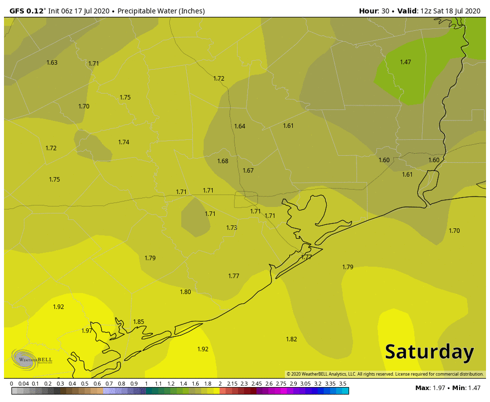
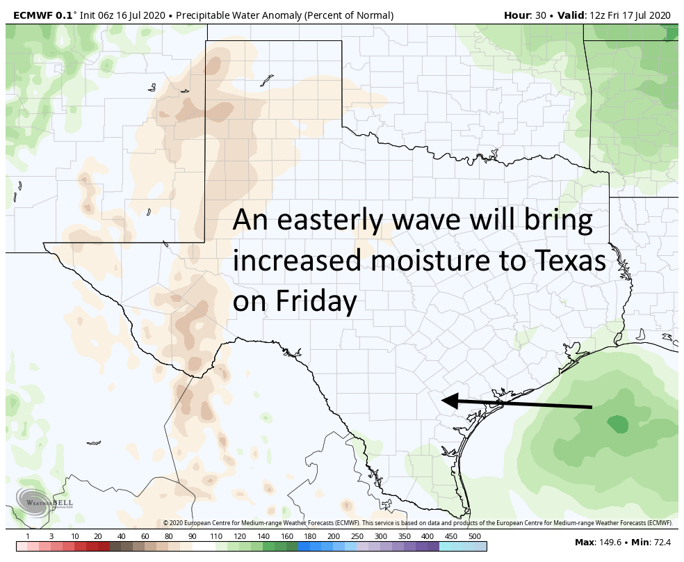
One effect of an easterly wave on Friday will be increased moisture levels. (Weather Bell)
Friday
Our weather pattern should really change on Friday. Highs pressure will back off just enough to allow a weak low pressure system to move from east to west across the area. This should bring scattered, light to moderate showers along the coast during the morning, and spread inland during the afternoon and evening hours. Will you get rain? If you live south of Interstate 10, chances are probably in the 50 percent range, and lower if you live north. Accumulations for some may be up to one-half inch, but most people will see less than this. Highs should otherwise be in the mid-90s.
Saturday and Sunday
The weekend should see fairly standard weather for Houston in July, which is to say highs in the low- to mid-90s, with partly to mostly sunny skies. We may see some isolated to scattered showers driven by the sea breeze, but overall rain chances will be quite low.
Next week
Most of next week should see highs in the low 90s, with a mix of sunshine and clouds. On average, each day should have around a 30 percent chance of rain, but of course some days will have better and worse chances. We’ll refine that forecast as we get closer to it.