Houston enjoying its coolest morning since April

Temperatures this morning have fallen into the 50s across much of the city—with only the coast holding out at slightly above 60 degrees—and this is the coolest weather Houston has seen since mid-April. This is also as cold as it’s going to get for a while here. But the good news, if you like fall, is that we should see a few more fronts in the next week to keep our region on the mostly dry and mild side going into next week.
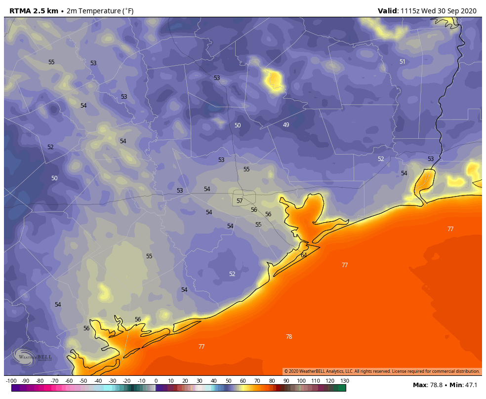
It’s an unreal fall morning across the Houston metro area. (Weather Bell)

Wednesday

Not much to say about today’s weather. We’re going to see sunny skies, with a high temperature in the mid-80s. Light winds will shift to come out of the southwest this morning, and that will slowly begin the process of returning the onshore flow. Lows tonight will probably be about five degrees warmer than Tuesday night.

Thursday

This will be a warmer day with the influence of a southerly flow, likely allowing high temperatures to push into the upper 80s under sunny skies. But just as Houston shows signs of heating up, a moderate push of cooler and drier air will arrive late Thursday night or Friday morning.

Friday and Saturday

This weak front should make for a splendid weekend, with highs in the low 80s, lows in the low 60s for all but the coast, and lots of sunshine. It’s not going to be “cold” by any stretch of the imagination, but it’s not going to be hot or humid either. This is fall in Houston!

Sunday

This should be another day like Thursday, as the influence of the onshore flow begins to warm things up. We should see highs in the mid- to upper-80s with partly sunny skies and moderately more humid air. However we think yet another weak (or maybe stronger?) front will arrive late on Sunday, or early Monday, to keep the heat and humidity in check.
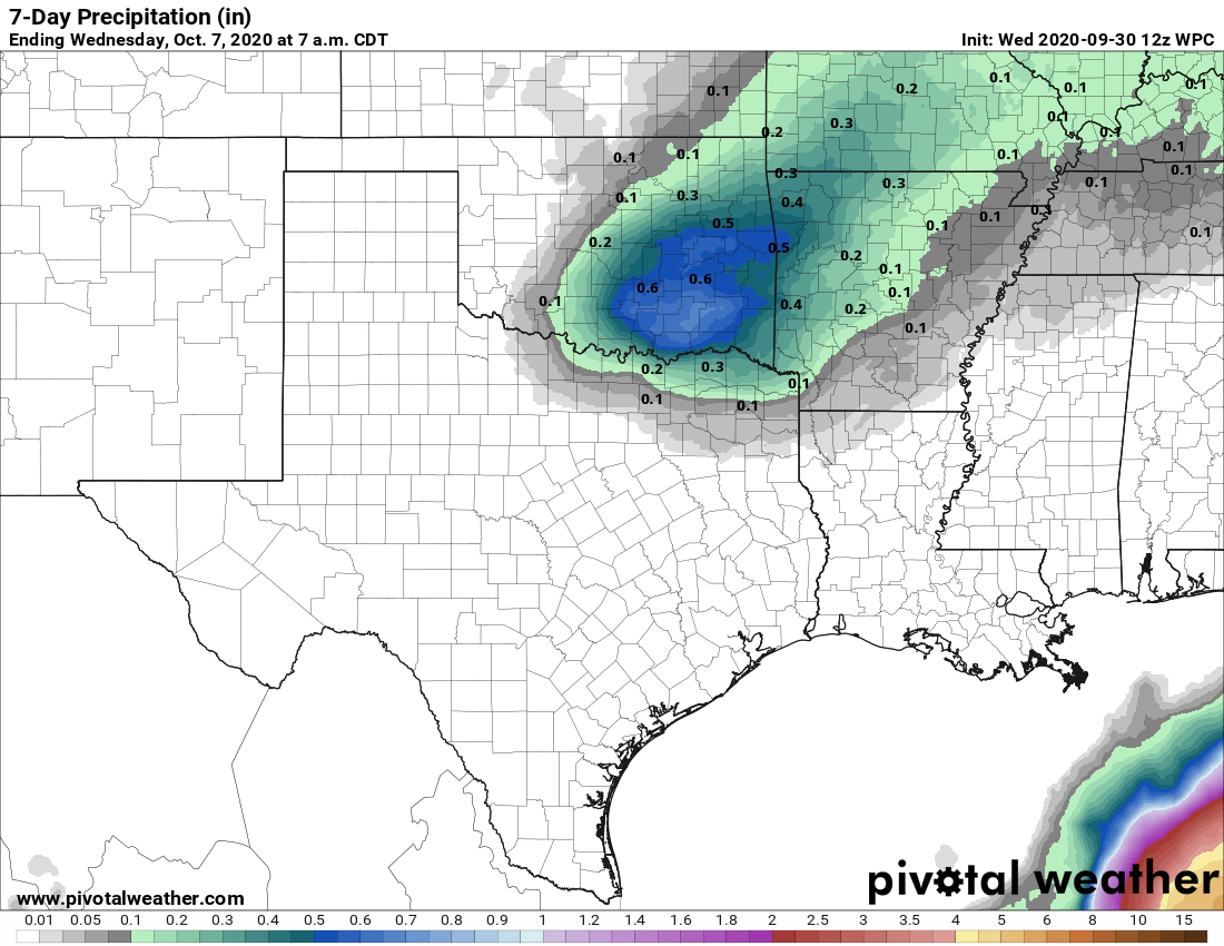
Houston’s 7-day rainfall forecast is bereft of rainfall. (Pivotal Weather)

Next week

As a result of Sunday or Monday’s front, the early part of the week should keep us in the realm of highs in the 80s, and lows in the upper 50s to 60 degrees. Some clouds may return by the middle or end of next week, but our first real rain chances probably don’t come until next Friday or Saturday.

Happy Fall Day Houston—you’ve earned it

Houston’s temperature officially reached 65 degrees at Bush Intercontinental Airport this morning shortly after 2 am, and from there it kept on falling. By shortly before sunrise, the low had dropped to 57 degrees. At Hobby Airport, in the midst of the city, the low reached 59 degrees on Tuesday morning. It all feels rather spectacular, and worth celebrating Fall Day.

24-hour change in temperature on Tuesday morning. (Weather Bell)

Tuesday

Simply put, today will be fabulous. There still will be a bit of wind out of the north, but it won’t be like Monday’s gusty conditions. Highs will likely only reach about 80 degrees despite sunny skies. And this evening, well, temperatures should drop a degree or two below what we saw on Monday night beneath clear skies. Winds will be calm.

Wednesday

After another cool morning—chilly, even, for far inland areas—this should be another splendid day for the area, with highs in the low- to mid-80s. As the frontal air mass begins to modify, expect lows on Wednesday night to be several degrees warmer.

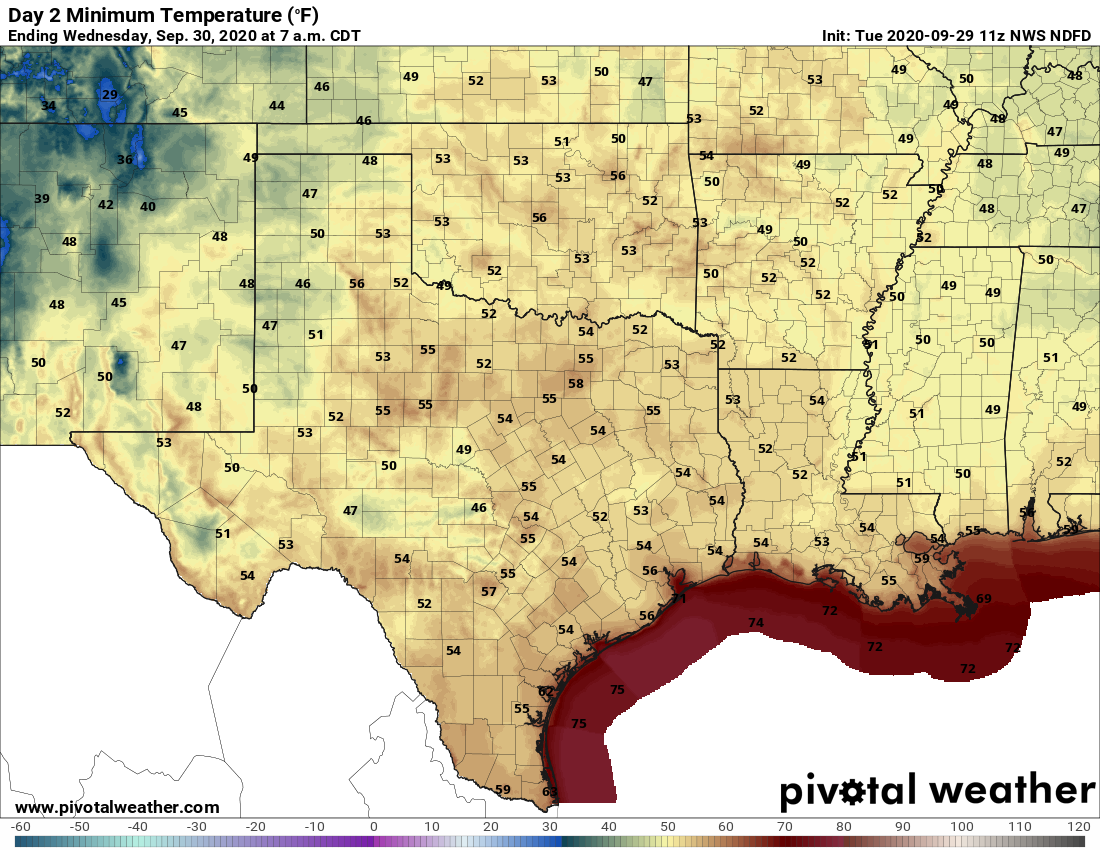
Low temperatures for Wednesday morning. (Pivotal Weather)

Thursday and Friday

These will be a pair of warmer days, with a few clouds possible on Thursday. Both days should see highs somewhere in the mid-80s, or possibly upper 80s on Thursday. Another, weaker front should push into Houston on Friday and this will set the stage for a nice weekend.

Saturday and Sunday

With another push of drier air, the first half of the weekend looks great, with highs on Saturday in the low 80s, and fairly low humidity. The onshore flow should return on Sunday, but I’d still expect highs to stay in the 80s, with plenty of sunshine. Should be a great weekend for outdoor activities.

European ensemble model for cloud cover (dark blue means none) for the next two weeks. (Weather Bell)

Next week

Right now it appears as though another modest front may make it into Houston on next Monday, or so, but details are a bit sketchy. The bottom line is that we expect mostly sunny skies through the middle of next week, by which time a chance of rain finally returns to the forecast.

Tropics

The National Hurricane Center has increased the chance that an area of low pressure in the northwestern Caribbean Sea will develop into a tropical depression or storm to 50 percent over the next five days. There are probably a couple of scenarios for this system, including a weaker storm tracking westward into Mexico, or eventually a strong storm moving north toward Florida. Again, while we can’t rule anything out, we have a hard time seeing how it would eventually move toward Texas.

Fall’s first real front arrives in Houston, and there was much rejoicing

The summer of 2020, which featured the 5th warmest July and 8th warmest August on record, threw two tropical cyclones at Houston, and offered unsparing humidity, died on Monday. It was 123 days old. Summer finally lost its fight with fall’s first truly strong front, which blew into Houston on the morning of September 28th. Services have been canceled due to a lack of mourners.

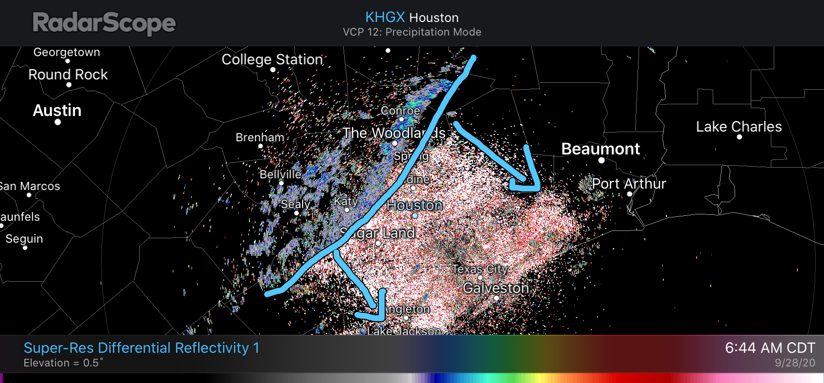
I realize that some people do like Houston summers, and that’s fine. But for the majority of us in Houston, there is nothing sweeter than the arrival of fall’s first real front. And my friends, that day is today. As of 6:45 am, the front has passed a line from The Woodlands to Katy, and it should be off the coast before noon.

Cold front position at 6:45 am CT on Monday. (RadarScope)

Monday

A thin, broken line of showers is accompanying this morning’s front, and clouds may linger for a few hours after its passage. After this we should see clearing skies, and a northerly breeze gusting to perhaps 20 or 25 mph. This will bring much drier air into the region. On Sunday evening, when I went for a walk, it was sticky—the dewpoint was 77 degrees. This evening, the dewpoint will be 25 or 30 degrees lower. The difference will be unreal. High temperatures today will probably crest at about 80 degrees and begin falling this evening. Low temperatures outside of Houston will likely drop into the 50s, reach about 60 in the city, and be a few degrees warmer right along the coast.

Tuesday and Wednesday

Hello, fall! Look for sunny skies, highs of around 80 degrees, and lows down around 60 degrees give or take. (Wednesday morning will probably be the coolest morning of the week for most locations). Oh, and there will be plenty of dry air.

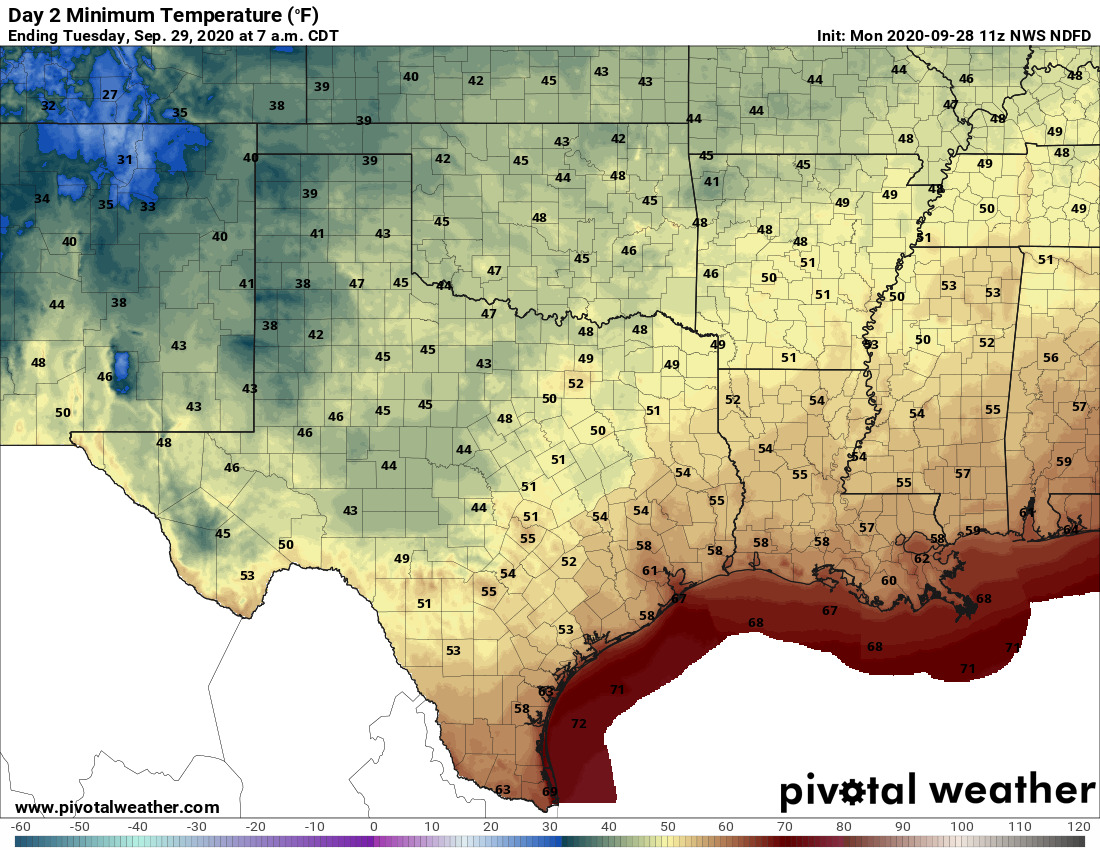
Forecast low temperatures for Tuesday morning. (Pivotal Weather)

Thursday

This day could be warmer, pushing into the mid- or upper-80s as the onshore flow returns.

Friday, Saturday, and Sunday

Right now the weekend looks quite nice, with a secondary push of dry air arriving on Friday or so. Our details about this part of the forecast are a bit sketchy, but generally we’d expect lots of sunshine this weekend, with highs of around 80 degrees, the low 80s, or maybe a bit warmer by Sunday. The bottom line, look for pleasant, sunny weather to prevail.

Tropics

The National Hurricane Center has begun monitoring a low pressure area over the northwest Caribbean Sea. Over the next week or 10 days this may eventually develop into a tropical storm, but we have no reason to think it would eventually track toward Texas.

Fall Day is coming to Houston, and it’s going to be glorious

Is anyone ready for Fall Day? We strongly believe it should be a Houston holiday. We declare Fall Day as the first day temperatures are forecast to drop to 65 degrees, or lower. For Houston this probably will occur next Tuesday, or Wednesday at the latest. That’s because we’re now pretty confident in a cold front crossing the area next Monday or Monday night. A rather nice front, in fact. More on that in a minute, but first I want to call your mind back to 2019.

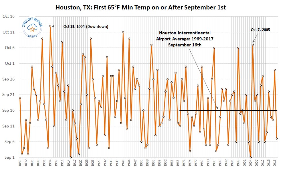
September of last year was a brutal affair, combining the pain of Tropical Storm Imelda’s flooding and the lack of a low temperature below 71 degrees. Houston did not get its first front until the first week of October, and the region’s first low temperature of 65 degrees or below did not come until October 8. This was the latest “front,” by our definition of the temperature falling to at least 65 degrees, in the 50 years the region’s “official” station has been sited at Bush Intercontinental Airport.

When is the first day of “fall” in Houston. (Brian Brettschneider for Space City Weather)

Anyway, if we celebrate Fall Day next Tuesday it will come on the 29th, about two weeks late. So far this year the region has had one front that died as it reached Houston, and another weak one that made it through (the low temperature got to 66 degrees on September 20th at Bush IAH). But now, we’re going to get out first bonafide fall front.

Friday

So where’s the sun? We thought we would see more sunshine on Thursday afternoon than we did, but we promise it’s coming. Today should see partly to mostly sunny skies, with highs reaching into the mid-80s. Light northerly winds will gradually shift to the east today, and to the southeast tonight. As a result low temperatures tonight probably will only fall to around 70 degrees for much of the area.

Saturday and Sunday

The weekend looks pretty nice for late September, with lots of sunshine and highs in the mid-80s to 90 degrees. Lows will be a few degrees warmer, likely in the low 70s for most. Due to the wind shift, it will be a little muggier than we’ve seen in recent days. There’s a very slight chance of rain, perhaps 10 percent, right along the coast on Sunday. But we doubt it.

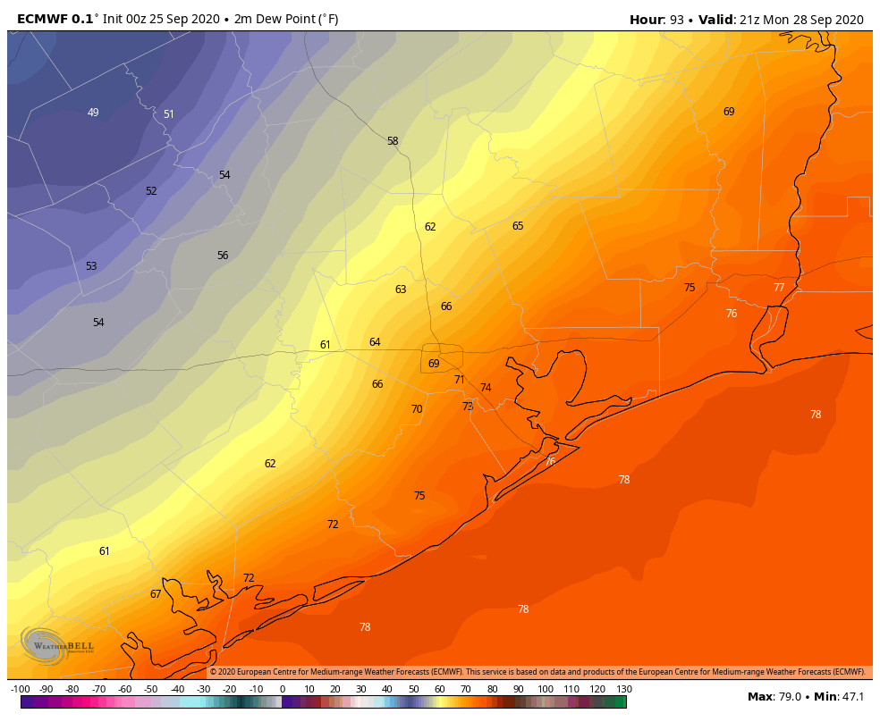
Dewpoint map shows the approximate location of the cold front on Monday, at 4pm CT, in the European model. (Weather Bell)

Monday

Temperatures on Monday are going to depend on the timing of the front. We can’t be precise with that right now, so I’d guess the front reaches the Interstate 69 corridor running through downtown Houston sometime during the afternoon hours and the coast by the evening. There may be some scattered showers along or ahead of the front’s passage, but right now this is nothing to get excited about. Lows Monday night should drop into the low 60s.

Remainder of next week

Our weather next week will be determined by the strength of the front, so there are still some details to be worked out. Generally, I think we can expect highs in the low 80s, overnight lows perhaps in the 50s for inland areas, and 60s along the coast. We’ll definitely see some notably drier air, and there’s the possibility of a reinforcing front by Friday or so to keep the Fall-train rolling into the weekend. But I don’t feel entirely confident about that yet.

See you all on Monday morning, or rather, Fall Day Eve.