We think hurricane season is pretty much over for Texas

Houston has had an astonishing month when it comes to tropical cyclones. Four weeks ago we were closely watching Hurricane Laura move along the southern coast of Cuba, toward the Gulf of Mexico. And of course, over the last few days, we dealt with heavy rains from Tropical Storm Beta. So amidst a record-setting tropics season, with more than two months to go until its official end on Nov. 30, could Texas really be done with hurricanes this year?

The answer, we think, is yes. Here’s why:

  • The historical odds of a hurricane striking Texas after today, September 24, are very low. They are 1-in-50 based upon records that go back more than 150 years.
  • When we start to see cold fronts push through the region it’s a good sign that the upper-level pattern is beginning to change, making it more difficult for a storm to move westward toward Texas. We had one front last week, we may get another weaker one on Monday, followed by a stronger one on Wednesday or Thursday. Fall is coming.
  • There is no imminent development. Aside from Beta’s remains, there is nothing on the National Hurricane Center’s five-day outlook.
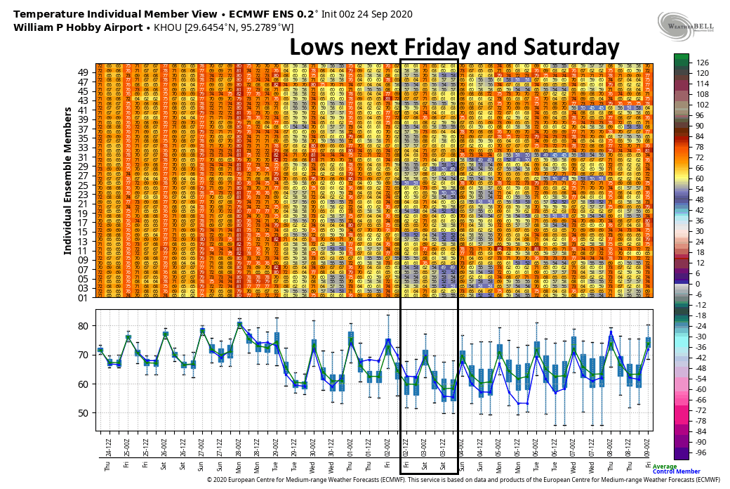
  • Finally, the European and GFS models are pretty quiet, in terms of tropics activity, over the next 10 to 14 days, which gets us into October.
  • Really, the only reason we’re not 100 percent confident that Texas will not see another hurricane this year is because it is 2020. Anything goes this year.
This map shows the tracks of all tropical cyclones in the 2020 Atlantic hurricane season. (Master0Garfield/Wikipedia)

The bottom line is that we have a lot of reasons to feel good about Texas, and the tropics, for the remainder of this hurricane season. We’re not here to tell you what to do, but if you want to breathe a sigh of relief, it’s probably warranted. Should anything threaten Texas from the tropics, we will of course let you know. But at this point we’d bet against it.

Thursday

Houston will continue to enjoy nice weather on the back side of Beta as it lifts from Louisiana into Mississippi. That means northerly winds, some clouds, and highs of around 80 degrees. Low temperatures tonight should drop into the upper 60s across the Houston area.

Friday

A similar day to Thursday, although with Beta moving further away our northerly winds will shift to become easterly. This, in concert with at least partly sunny skies, should allow high temperatures to get into the mid-80s.

Saturday and Sunday

This should be a fairly warm late-summer weekend. Look for mostly sunny skies, with highs in the upper 80s to about 90 degrees. Lows will generally only fall to around 70 across the region. Rain chances are probably 10 percent or less each day.

Highlighting lows for Oct. 2 and Oct. 3 from the European ensemble forecast. (Weather Bell)

Next week

Our weather early next week is difficult to parse, because we’re not sure whether a moderate front will make it through on Monday. If it does we can expect some cooler weather, but if not we’ll probably see a couple of more days with highs of around 90 degrees. Regardless, we have pretty high confidence that a stronger front will make it through on Wednesday or Thursday. There remains a pretty good chance that at least northern parts of the metro area will see lows in the 50s by late next week or the weekend—making it really feel like fall. Is anyone else ready for fall?

Some final thoughts on Beta, and looking forward to fall weather

Well, it’s over. The remains of Beta are crossing Galveston Bay this morning, and with all of the storm’s heaviest precipitation far to its east, we are done. Houston should begin to see some rather fine weather later today and Friday, on the backside of Beta with a northerly flow. And then, while we cannot absolutely promise this, our confidence is fairly high in a robust, fall-like cool front arriving in about one week’s time. Before the forecast, however, I wanted to share a few quick thoughts about our not so dearly departed tropical storm.

It could have been much worse

Let me tell you, if you would have told me a tropical cyclone was going to make landfall about 120 miles down the coast from Galveston, in mid-September, I could envision all manner of nightmare scenarios.

But we had two big allies over the last week; moderate wind shear to prevent Beta from strengthening, and dry air over the state from a weak front that disrupted its circulation and prevented the formation of several, thick bands of rainfall. Instead, if you watched the radar closely, there was only ever really one strong band that was perhaps 10 to 15 miles across. This just happened to set up over Houston on Monday and Monday night, hitting the communities of Friendswood, Pearland, Sugar Land, and more.

Here is a map of the three-day rain totals that show this narrow corridor of 10 to 16 inches of rain over south and southwest Houston. The vast majority of the rest of the upper Texas coast saw 6 inches of rain, or less, from this storm.

Three day rain totals from Tropical Storm Beta. (NOAA)

While Beta was not as long a duration event as Hurricane Harvey (which, by the way, dropped 40-60 inches of rain over much of the area in yellow and green above), three days of potentially heavy rainfall is a long time. Slow-moving tropical systems are no joke. With Beta, not only was there just one main band, but its rainfall rates were not particularly high. I believe this was due to dry air, but I am not sure and will look forward to a post-storm analysis. In any case, we generally saw rainfall rates of 0.5 to 1.5 inches under this band, with a few exceptions, versus rates of 3 to 6 inches that tropical storms often produce.

We have not done nearly enough

Three years have now passed since Harvey, and a tropical storm that we discussed above as pretty moderate, brought the area’s flood systems to its knees. Only the Clear Creek watershed south of Houston, which received 7 to 16 inches of rain across much of its extent, really flooded in a significant way. But a lot of other bayous, like White Oak, Cypress, Buffalo, came up to the top of their banks or briefly spilled over them. A tropical storm that brings a range of 5 to 15 inches rain across Houston, with rainfall rates below 2 inches per hour, is a fairly common event. We will see more like this, and more that are much worse in years ahead.

I know the community has done some nice things, like work on Brays Bayou, since Harvey. But it is not nearly enough. Local, state, and federal officials need to work together to develop and implement a broader flood management plan. I know that is difficult in our nation’s political climate, but the desirability of living in Houston is at stake. Who enjoyed the stress about flooding over the last three days?

I missed Matt

Matt’s wife delivered a son early on Sunday night, so I was flying solo on the site for a couple of days amidst the height of the storm. It sure made me value the fact that I normally have someone to share the load with, and talk through the forecast. Clearly, we need to chain Matt to his desktop when future inclement weather threatens.

Houston’s forecast

There is not a whole lot to say about our weather ahead. All heavy rainfall from Beta has exited the area, and by this afternoon we should start to see some sunshine across Houston. High temperatures will probably get to around 80 degrees. All of the bayou flooding issues we’ve seen, including Clear Creek, should end by this afternoon. Northerly winds will bring slightly drier air into the region, so temperatures tonight may drop into the upper 60s tonight.

Low temperature forecast for Thursday morning. (Pivotal Weather)

Friday and the weekend

The weekend looks outstanding for late summer. I think we can generally expect lots of sunshine, highs ranging from the mid-80s to 90 degrees, and lows around 70. It will be humid, yes, but not as humid as it can get in Houston. We’re definitely entering the end stages of summer in Houston. Rain chances remain low.

Next week

This warm, but not too warm trend will likely continue until about Wednesday of next week when there is fairly good agreement among the global models in a cold front passage. Since this is still a week away it remains too early to say definitively that this will happen, but the signal is pretty strong, and the overall flow pattern in the atmosphere is supportive. I think at least part of the Houston region will have a good shot at lows in the 50s during the second half of next week.

Getting ready to say goodbye to Beta (and good riddance)

10:15 pm CT Tuesday: The remnants of Beta are continuing to trudge toward the east-northeast, and that’s good news for the greater Houston area. The strongest, outer band has already moved well east of the city, and now lies mostly north of Harris County. And it should keep right on going thanks to Beta’s progressive movement.

We’ve seen some strong storms this evening that have dropped 2 to 5 inches of rain over north and northwest Harris County, including areas such as Cypress Creek. This has brought the creek to near bankfull at some locations. But these storms appear to be moderating somewhat, and slowly lifting out of the area. The heaviest rains are now moving into areas such as The Woodlands, Kingwood, and Liberty that have largely been untouched, heretofore, by Beta’s heavy rains. Some of these locations may pick up 2 to 4 inches, but that’s probably about the top end of things tonight because the storms seem to be moving through at a reasonable clip.

NAM model forecast for rainfall between Tuesday evening and Wednesday, noon. (Weather Bell)

There is a secondary circulation near Beta’s center this evening, and this is producing some light to moderate showers over Pearland, Sugar Land, League City, and other areas hard hit by Beta on Monday night. However, we have no expectation that this inner circulation will “blow up” as it moves through these areas and into Houston. These storms may put down a few tenths of an inch of rain, perhaps as much as one inch in a few areas, and then move on.

Generally, we still expect any heavier rain to move east of Interstate 45 by around midnight, or shortly after; and for the messy stuff to move beyond Harris County by around sunrise on Wednesday. From there the focus moves into East Texas, where places like Lumberton or Silsbee may see some very heavy rain on Wednesday morning. We are close to the end of this one, folks, and damn if it doesn’t feel good.

Our next post will come on Wednesday morning, after I’ve had some sleep.

Rainfall threat shifting north and east Tuesday night

8:00 pm CT Tuesday Update: Our forecast from earlier remains largely on track this evening. We are seeing the threat of heavy rainfall shift from south and central Houston toward the north, and eventually northeast. This is happening as the remains of Beta are tracking toward the northeast. At this time its ragged center is approaching Lake Jackson, and should move beyond Houston sometime on Wednesday morning.

Radar snapshot shortly before 8pm CT on Tuesday. (RadarScope)

A thin band of heavy rainfall is essentially stretched from Bolivar Peninsula through Baytown, Aldine, and Jersey Village. A few of the strongest thunderstorms in this band are producing rain at 2 inches per hour, but most of the band is dropping rain at lower rates. We are starting to see rises along White Oak Bayou as a result of these rains, but so far it remains within its banks. We’ll keep an eye on it.

These storms should slowly shift north and east as Beta’s center continues to move onward. This threat of overnight rainfall is pretty well captured in the most recent run of the NAM model, which depicts rain totals between 7pm CT Tuesday night and 7am Wednesday morning.

NAM model forecast for rainfall accumulation between 7pm CT Tuesday and 7am Wednesday. (Weather Bell)

As you can see, we generally expect the areas hardest hit on Monday night—south and southwest of Houston—to avoid a lot of heavy rainfall. The northeast quadrant of Harris County has largely been spared over the last two days, with most areas seeing less than 2 inches of rain. Therefore the potential of 4 to 6 inches of rain dropping tonight north and east of Houston is something those areas should be able to accommodate.

Our best high resolution models still suggest the heaviest rain will push east of Interstate 45 by around midnight tonight, or shortly thereafter, and it should move entirely east of Harris County by around sunrise on Wednesday. The threat later on Wednesday morning will shift into East Texas, possibly including Beaumont and Port Arthur.

The most important message tonight is that if you don’t have to go out, you should remain home. The remnants of Beta will be pushing through the area, and tropical rainfall rates can pulse up and quickly flood streets. So stay home, and wait for better weather tomorrow. It’s definitely coming.

Our next post will come by or before 11 pm CT Tuesday night.