Laura moving near Cuba, confidence increases slightly in track forecast

I will not lie. (We never do, and that’s a promise you can bank on). When the National Hurricane Center issued its updated track forecast at 10 am CT this morning I had my doubts. Forecasters there seemed too conservative in not moving the track of Laura closer to Houston, as that is where a lot of the model data indicated it would go. However, in going over all of the just released data from 12z models, their track forecast (shown below) now looks pretty good. So, kudos to the pros in Miami.
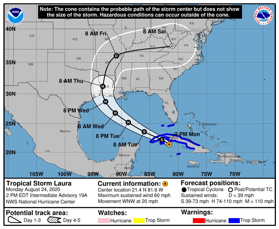
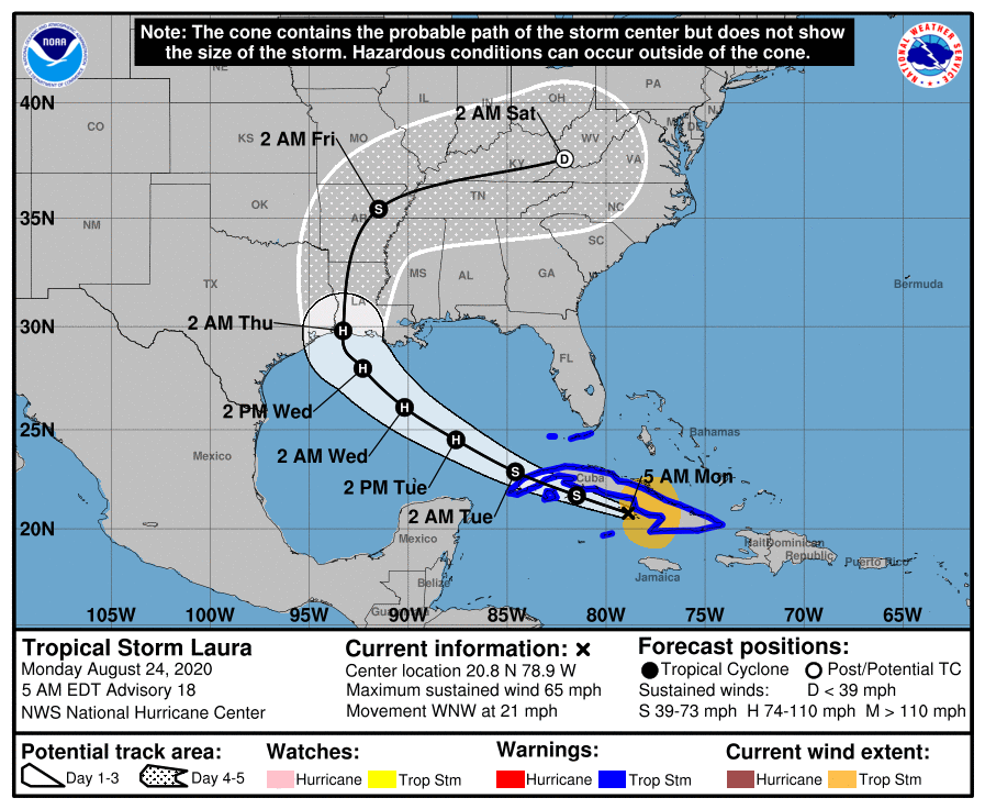
Monday 10 am CT forecast from the National Hurricane Center.

What does the 12z data show? Several models have made slight adjustments eastward today, but the most significant movement has come from the UKMET model, produced by the United Kingdom. This is not the world’s best global forecast model, but it is competitive, and something we often look at. In the case of Laura, it has had some of the best performance to date since tracking began a few days. This meant we have weighted it a little bit higher for this storm.

One of the things that has concerned us is that the UKMET, although an outlier, had been frequently bringing Laura to the central or upper Texas coast. This would have placed Houston, Galveston, and the upper Texas coast on the powerful right side of the storm. However, in a just released run of the model, the storm’s landfall location has made a sizable jump east, from near Corpus Christi to the Texas-Louisiana border:
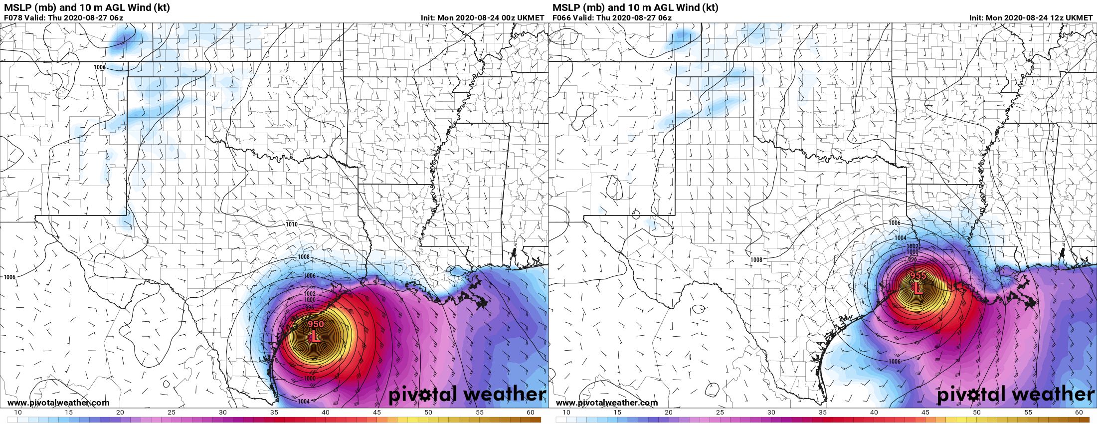
A plot of the UKMET model released early Monday morning (left) compared with the latest run from Monday early afternoon. (Pivotal Weather)

This brings the UKMET more in line with other global models in predicting a landfall near the Texas-Louisiana border, or slightly east of there. This gives us more confidence in a solution that brings Laura onshore just far enough east of Houston to keep the worst of its winds, waves, and rains away from the area. But this does not mean the track forecast is locked down—we still have a fair amount of uncertainty there. There are some very fine details in the positioning of several features in the upper atmosphere, and these could easily move a bit in the next day or so. That would be enough to nudge the forecast back toward Houston. So please, do not let your guard down and keep making preparations. But maybe, breathe slightly easier if you live in Houston. If you live in Beaumont or points east, the threat remains very high.

One thing I think we can answer is when we should have clarity on what Laura is really going to do. I am reasonably confident that the track will be dialed in by this time tomorrow, after Laura has come across the western edge of Cuba and emerged into the Gulf of Mexico. By this time it should be forming a more well defined center of circulation, and the models will have ingested better initial conditions. So our long, uncertain wait for some answers should finally come to an end within 12 to 24 hours. As ever, thank you for your patience.

To update the percentages I’ve been using for various scenarios, this is what I would now go with:

Scenario One: Near or direct impact on Houston by a powerful hurricane. (30 percent)

Scenario Two: Powerful hurricane near or east of Texas-Louisiana border (70 percent)

Scenario Three: Weaker storm, central or southeastern Louisiana (~0 percent)

I will be conducting a Facebook Live video at 2pm CT that you can find on our page there. Matt will provide our next update no later than 9pm CT tonight.

Laura will arrive in three days or less, Houston should prepare now for possible impacts

Good morning. We’re continuing to track the severe threat posed by Tropical Storm Laura, and the majority of this post will be devoted to that. However, before getting into hurricanes, just a word about our weather for Monday and Tuesday. We expect partly to mostly sunny skies, with highs generally in the mid-90s. Both days will see a chance of scattered showers, especially along the coast, but we don’t expect anything too organized. Weather beyond this will depend upon the movement of Laura.

Tropical Storm Marco

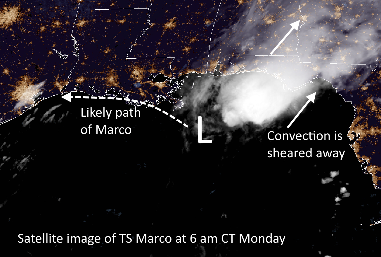
Marco is weakening this morning (50 mph) as it encounters wind shear over the northern Gulf of Mexico. It is expected to approach the southern coast of Louisiana tonight, and then slowly begin to track westward toward Texas. As its main convective activity will be sheared away, it should not bring any noticeable weather changes to the greater Houston region. However, Marco’s movement may play into Laura’s final landfall location as that storm nears the Gulf coast by mid-week.

Tropical Storm Marco satellite image at 6 am CT. (NOAA)

Tropical Storm Laura

Here’s the deal with Laura. At this time there is a somewhat improving model consensus for where the storm will make landfall late Wednesday night or early Thursday, likely between Galveston Island and the south-central Louisiana coast. The National Hurricane Center has the storm coming into the coast near the Texas-Louisiana border, but we do not have nearly enough precision to rule out small-to-moderate changes in the track. And for the Houston region, any small shifts in the track westward will change our local forecast dramatically.

Put succinctly: Along the current track forecast Houston would see only modest effects in terms of wind, rain, and surge from a Laura landfall in southwestern Louisiana. However, a subtle shift 50 miles or more to the west would begin to bring serious effects into Houston. A shift of 100 to 150 miles would bring a potentially catastrophic hurricane into the region. This is entirely within the realm of possibility, and therefore the Houston-Galveston metro area needs to prepare now for a land-falling hurricane—possibly a major one. (This goes double for the Beaumont-Port Arthur area).

National Hurricane Center forecast track for 4am CT Monday.

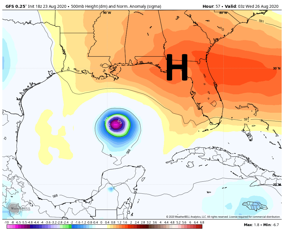
The dominant steering factor for the storm will be strength of a ridge of high pressure building over the southeastern United States, which will be influenced by a weakening Marco and a trough over Texas. It would only take a small change in these large scale features to change the point at which Laura makes a northward turn, which is why we’re unable to pin down the storm’s ultimate movement. In terms of intensity, Laura has remained near the southern coast of Cuba overnight, staying just offshore. This has allowed the system to maintain its status as a strong, 65-mph tropical storm. It still has the potential to blow up into a Category 2, 3, or even 4 hurricane over the open Gulf of Mexico.

Assuming a land-falling Laura near the border of Texas and Louisiana, the eastern half of the metro area has a decent chance of seeing tropical storm-force winds, likely arriving Wednesday afternoon or evening. Storm surge and tides will be entirely dependent upon track and intensity, but along the current forecast track probably would only be a few feet higher than normal. Overall precipitation would likely be on the order of 1-2 inches of rain, mostly east of Interstate 45. Again, I cannot state how dramatically these effects could change with a change in Laura’s track.

Last night I posed three different scenarios for Laura, and I wanted to update those very rough percentages in light of new data overnight.

Scenario One: Near or Direct impact on Houston by a powerful hurricane. (40 percent)

Scenario Two: Powerful hurricane within 50 miles of Texas-Louisiana border (55 percent)

Scenario Three: Weaker storm, central or southeastern Louisiana (5 percent)

Our next update will be posted no later than 2:30pm CT, and quite possibly sooner.

Laura now grazing Cuba, set to threaten Texas and Louisiana by mid-week

Good evening. I’d like to welcome our new readers to the site—whether you found us through a friend or family member, Google, Facebook, Twitter, Instagram, or of course our MySpace page. Just kidding about the last one, sorry Tom. Anyway, if you don’t want to miss our updates, you can subscribe to our email list in the box on this page. Doing so sends you our complete posts immediately after publication (and nothing else).

Alright, on to the forecast. We’re still really struggling with the evolution of Tropical Storm Laura, and a large part of the uncertainty involves the movement of its center over, or just south of Cuba the next day or so. Laura does not have a particularly well defined center and its interaction with the island may cause the center to re-form. Any of these perturbations could have implications for the storm’s track downstream. This is one reason why the models are struggling with how to handle Laura’s ultimate path.

The strength of the southeastern ridge, shown above, will determine Laura’s track. (Weather Bell)

Another factor is Marco, which we still don’t think will have a sensible effect on weather in the Houston metro area. It seems likely that a “stronger” Marco, maintaining hurricane strength on Monday as it nears the Louisiana coast, would amplify a ridge of high pressure over the southeastern United States. This would push Laura more westward, toward Texas. However, a weaker Marco would probably allow for Laura to follow a more northwest track across the Gulf of Mexico, toward Louisiana. These, and more details, are the reasons why overall confidence in Laura’s track remains low. Because of this uncertainty I thought it might be helpful to outline three scenarios that I think are possible, along with their likelihood of happening.

Scenario One (30 percent)

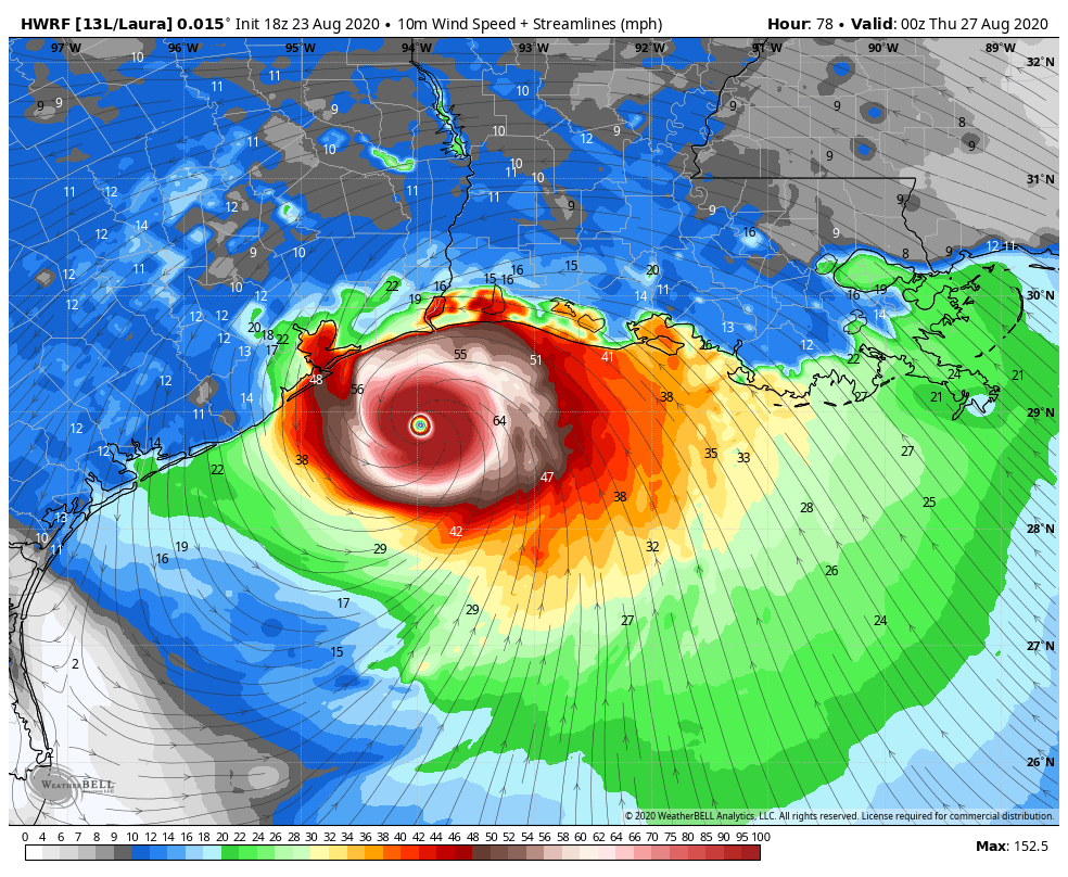
In this scenario the ridge of high pressure remains strong, and drives Laura toward Matagorda Bay or Galveston Bay very late on Wednesday, or early Thursday. This would allow for maximum time over the warm Gulf of Mexico, and we could see Laura coming ashore as a powerful Category 2, 3, or even 4 hurricane. This obviously would be a very bad deal for Galveston, Houston, and points east in terms of storm surge and winds. This would necessitate coastal evacuations and lead to widespread power outages, among other problems. Rainfall would be less of a concern because we expect Laura to scoot through fairly rapidly.

The HWRF model shows a strong hurricane approaching Galveston Bay at 7pm CT Wednesday. (Weather Bell)

Scenario Two (50 percent)

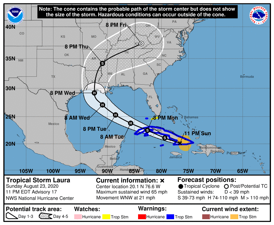
In this scenario, which is basically the “skinny black line” on the National Hurricane Center’s forecast, a reasonably strong Category 2 Hurricane comes ashore near the Texas-Louisiana border, or just east of there. In this scenario Houston sees some briefly gnarly winds, possibly gusting to hurricane force on the east side of the city. But beyond some relatively short-lived power outages, conditions should not be too extreme in the metro area. This would, of course, be a bad storm for Beaumont and southwestern Louisiana.

The 10 pm CT official track from the National Hurricane Center shows landfall just right of “Scenario Two.”

Scenario Three (20 percent)

In this case Laura comes off Cuba and begins moving almost due northwest, toward New Orleans and southeastern Louisiana by late Tuesday night or Wednesday morning. With less time over the Gulf this is a weaker storm. Houston would see almost no significant impacts from such a scenario, but it could cause significant surges or flooding in New Orleans, Mississippi and Alabama.

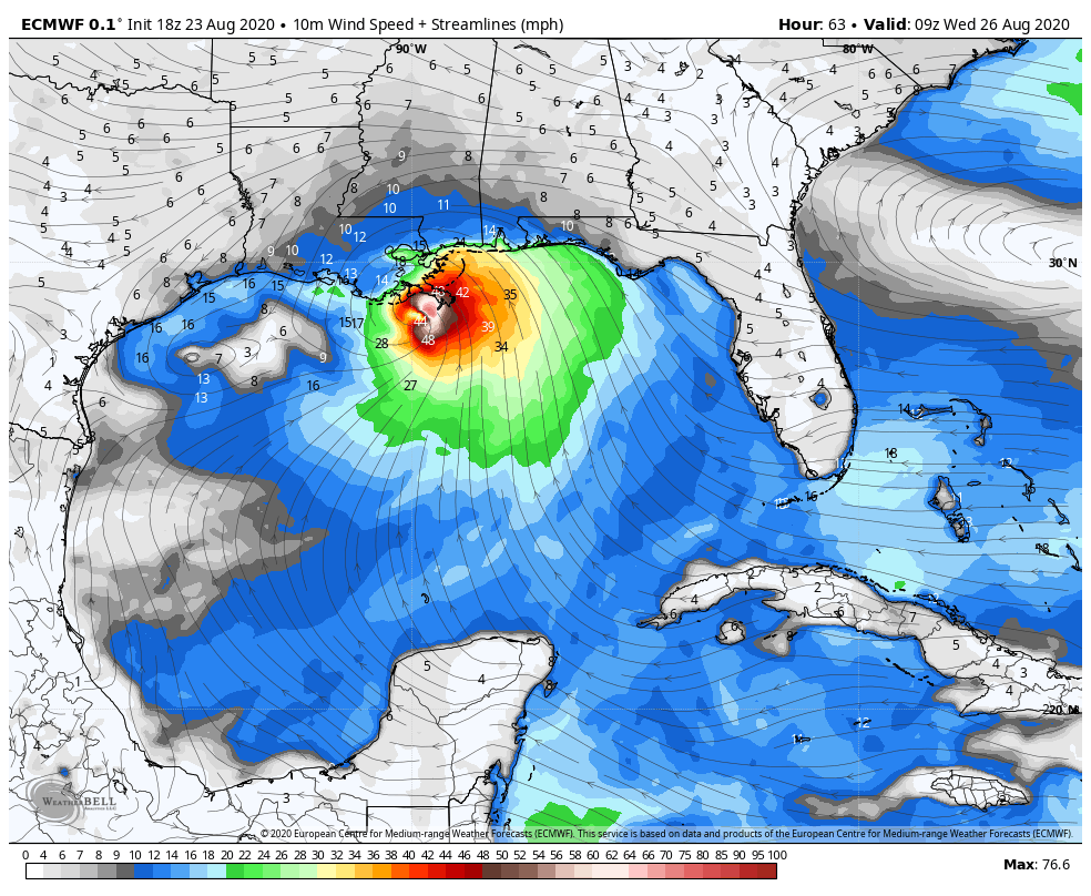
European model depiction of Laura at 4am CT Wednesday. (Weather Bell)

For the last two runs the deterministic output from the European model has more or less depicted this third scenario, along with the Canadian model. For this reason we can’t entirely discount it.

We hope to have better answers for you tomorrow on all of this, when we’re going to reach the point when final decisions on evacuation and other preparation activities will need to be made for the metro area.

Our next update will be no later than 8:30 am CT.

We are taking TS Laura very seriously, but its destiny is far from certain

Good afternoon. There’s a lot of ground to cover in this post, but we wanted to start with this: Tropical Storm Laura remains the region’s primary threat, and you really need to be paying attention. Today, you should be thinking about what you would do if a strong hurricane were to make landfall over the Houston-Galveston metro area on late on Wednesday or Thursday. Let us be clear: We are not saying that is going to happen. But it is well within the realm of possibility, and you should be thinking about what actions you would take, so that you are ready put them into play when the forecast tightens up.

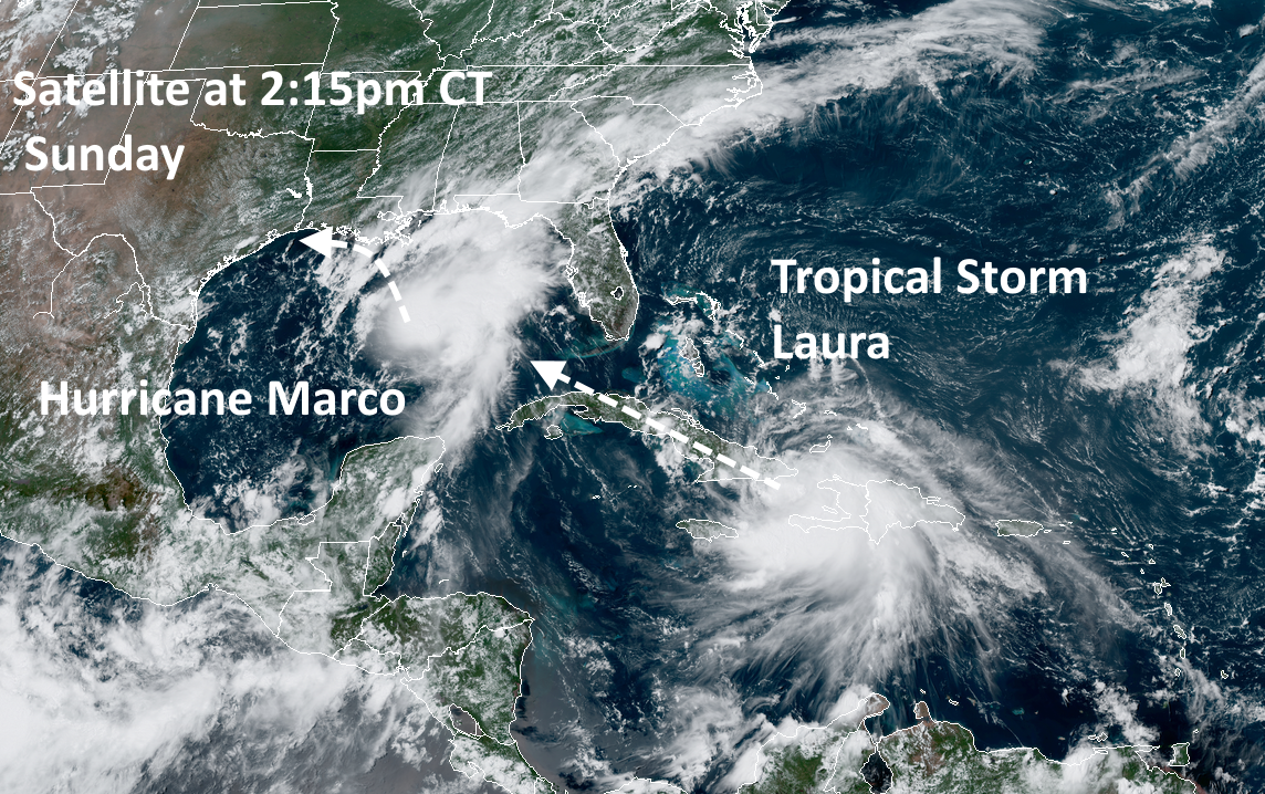
Satellite overview at 2:15pm CT on Sunday. (NOAA)

For this post, we will discuss the forecast for Marco, briefly, and Laura. And we will also try to answer some of your basic questions about impacts, evacuations, and more.

Hurricane Marco

Marco became a hurricane today, with 75 mph winds. The storm is moving north-northwest at 14 mph, and this should bring its center very near the Louisiana coast by Monday evening. We still aren’t sure whether this storm will move all the way onshore Louisiana, or remain near the shore, and then start to fall apart as it tracks westward along the Louisiana coast toward Texas. However, because most of the winds and heavy rainfall should remain to the east and north of the center, we do not anticipate severe conditions in the Houston region from Marco.

Probably the most significant thing about Marco now is that it seems plausible that the storm will slow down enough to potentially interact with Laura. This would not create some kind of “super storm” but may play some role in the track of Laura. Here’s one possibility:

Tropical Storm Laura

This system remains the key threat. Laura has moved across Hispaniola and maintained a reasonable structure. It will now spend Sunday night and most of Monday moving across Cuba before emerging into the Gulf of Mexico on Monday evening. Thereafter Laura will have 48 to 60 hours over warm waters, and an atmosphere favorable to intensification. It is reasonable to expect anything from a Category 1 to Category 4 hurricane to spin up on Tuesday or Wednesday over the open Gulf of Mexico. The situation is further complicated by Marco, which will not be all that far ahead of Laura, and the two systems may interact in ways that are difficult to predict even by the most sophisticated computer models in the world.

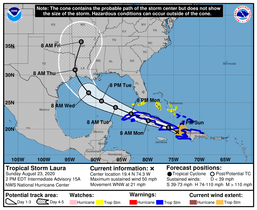
We simply have not received much clarity today in regard to a track forecast today. As a result, the National Hurricane Center’s 10am CT forecast track for Laura (shown below) is unlikely to shift much. Because of the broad uncertainty in the global model ensembles we are still reasonably looking at a track anywhere from Matagorda Bay, up through Houston, Beaumont, and across much of the Louisiana coast. For this reason, it’s probably not worth paying much attention to the “skinny black line” right now.

We don’t anticipate much shift in the official forecast track later today. (National Hurricane Center)

I think the hurricane center’s forecast is about as good as you could get considering all the uncertainties, but the bottom line is that this forecast can and probably will shift rapidly over the next day or so. Sorry, I know you want definitive answers. We don’t have them, and I wouldn’t trust anyone who says they do.

Alright, let’s get to some your most frequently asked questions below.

See full post