Good afternoon. There’s a lot of ground to cover in this post, but we wanted to start with this: Tropical Storm Laura remains the region’s primary threat, and you really need to be paying attention. Today, you should be thinking about what you would do if a strong hurricane were to make landfall over the Houston-Galveston metro area on late on Wednesday or Thursday. Let us be clear: We are not saying that is going to happen. But it is well within the realm of possibility, and you should be thinking about what actions you would take, so that you are ready put them into play when the forecast tightens up.
For this post, we will discuss the forecast for Marco, briefly, and Laura. And we will also try to answer some of your basic questions about impacts, evacuations, and more.
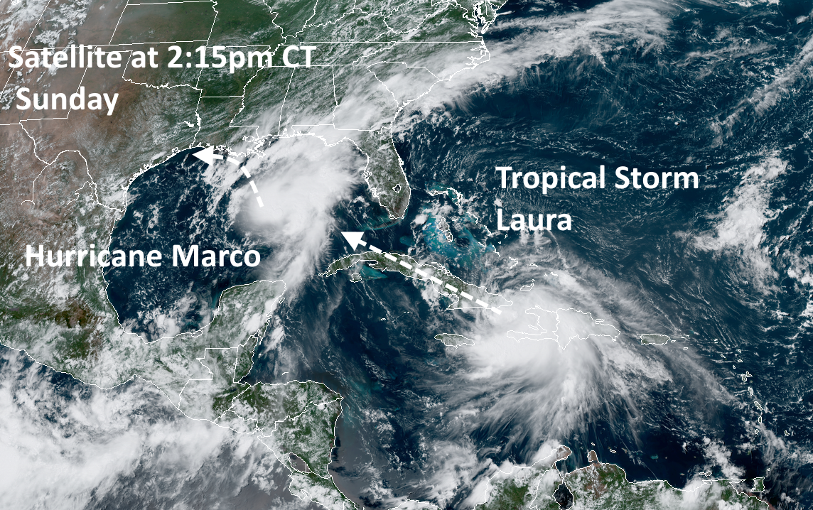
Hurricane Marco
Marco became a hurricane today, with 75 mph winds. The storm is moving north-northwest at 14 mph, and this should bring its center very near the Louisiana coast by Monday evening. We still aren’t sure whether this storm will move all the way onshore Louisiana, or remain near the shore, and then start to fall apart as it tracks westward along the Louisiana coast toward Texas. However, because most of the winds and heavy rainfall should remain to the east and north of the center, we do not anticipate severe conditions in the Houston region from Marco.
Probably the most significant thing about Marco now is that it seems plausible that the storm will slow down enough to potentially interact with Laura. This would not create some kind of “super storm” but may play some role in the track of Laura. Here’s one possibility:
A note on the 12Z ECMWF:
The rightward track of #Laura into SE Louisiana appears to be due to #Marco falling apart on the model, leaving its remnants in the gulf, which then pivot Laura to the right. Can’t guarantee this doesn’t happen, but so far, Marco is holding together. pic.twitter.com/3f9puGOiFQ
— Levi Cowan (@TropicalTidbits) August 23, 2020
Tropical Storm Laura
This system remains the key threat. Laura has moved across Hispaniola and maintained a reasonable structure. It will now spend Sunday night and most of Monday moving across Cuba before emerging into the Gulf of Mexico on Monday evening. Thereafter Laura will have 48 to 60 hours over warm waters, and an atmosphere favorable to intensification. It is reasonable to expect anything from a Category 1 to Category 4 hurricane to spin up on Tuesday or Wednesday over the open Gulf of Mexico. The situation is further complicated by Marco, which will not be all that far ahead of Laura, and the two systems may interact in ways that are difficult to predict even by the most sophisticated computer models in the world.
We simply have not received much clarity today in regard to a track forecast today. As a result, the National Hurricane Center’s 10am CT forecast track for Laura (shown below) is unlikely to shift much. Because of the broad uncertainty in the global model ensembles we are still reasonably looking at a track anywhere from Matagorda Bay, up through Houston, Beaumont, and across much of the Louisiana coast. For this reason, it’s probably not worth paying much attention to the “skinny black line” right now.
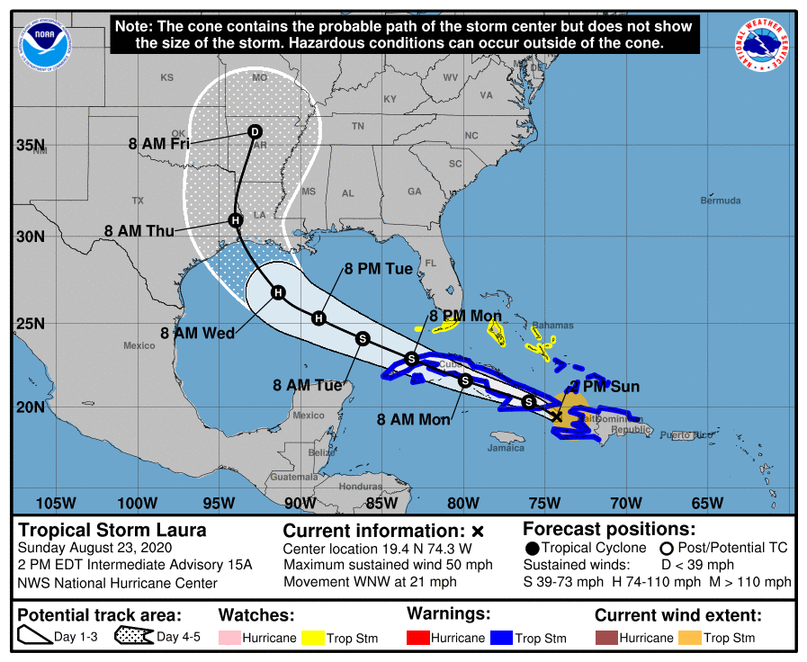
I think the hurricane center’s forecast is about as good as you could get considering all the uncertainties, but the bottom line is that this forecast can and probably will shift rapidly over the next day or so. Sorry, I know you want definitive answers. We don’t have them, and I wouldn’t trust anyone who says they do.
Alright, let’s get to some your most frequently asked questions below.

When will we know what Laura is going to do?
Assuming we are between three and four days from a landfall somewhere along the Texas or Louisiana coasts with Laura, historical averages say we should be getting closer to having an accurate forecast. For the National Hurricane Center, the average track position error at 3.5 days before landfall is about 120 miles, which is a little bit greater than the distance between downtown Houston and the Texas-Louisiana border on Interstate 10. In terms of intensity, you would expect the National Hurricane Center forecast for sustained to be accurate to within about 20 mph, plus or minus.
However, we have fairly low confidence in both of these forecasts. First of all, the track forecast is problematic because we have respectable model guidance producing a final landfall location for Laura anywhere from north of Corpus Christi all the way through most of Louisiana, almost all the way to New Orleans. Second, we don’t really know how much (if at all) Cuba will weaken Laura, and then it is just hard to predict when and how much the storm will rapidly intensify over the Gulf of Mexico.
With all that said, I expect confidence in our forecasts to increase steadily over the next 24 hours.
What are the biggest threats from Laura?
As you plan your final hurricane preparations please do not use Hurricane Harvey as a template. Laura is expected to move fairly quickly after the storm makes landfall. This reduces the threat of inland rainfall. However, Laura does have the potential to produce strong-to-devastating winds as well as produce a storm surge, driving water 10 to 15 feet above normal tide levels. The extent of winds and surge will not be determined until we have a better handle on the storm’s forecast.
Should I evacuate?
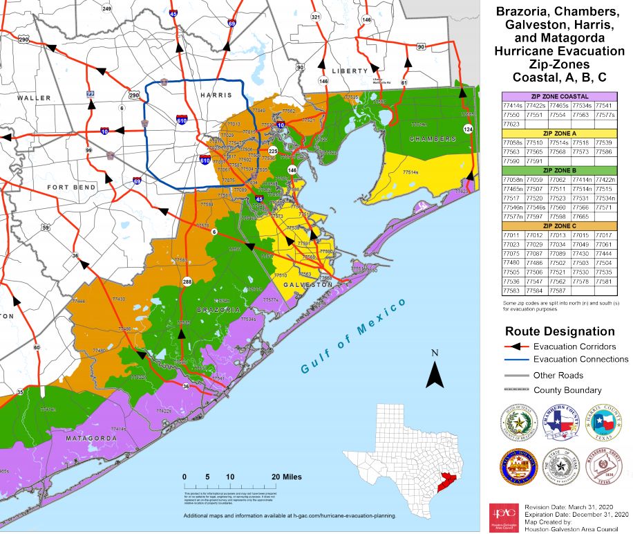
This is a pertinent question to be asking right now, but we still don’t know enough about the threat to provide a definitive answer. The age-old advice during a hurricane is that you evacuate from a storm surge, but take shelter in your home from wind. Effectively, for the Houston area, this means the closer you are to the coast, the higher your risk for surge. These “zip zone” maps (click here to download medium, and large-sized maps) show the risk in this area by zip codes.
There are other considerations. In the event of a bad windstorm we might expect power outages to last for one to two weeks at some locations. If there is a medical reason why this is unacceptable for you, factor that in. There is also the background complication that we are living through a pandemic, and we offered some suggestions on that earlier this summer with regard to evacuations. City and county officials are responsible for calling for evacuations, and we recommend heeding their warnings.
The bottom line on evacuations is that now is not necessarily the time to act, it is the time to plan for under what circumstances you would evacuate, and where you would go.
When would Houston start to see effects from Laura?
Most likely we would start to see an increase in winds from Laura sometime on Wednesday, probably during the evening hours. But it is really difficult to say much beyond this without better knowledge of Laura’s track and intensity
Will I lose power?
Again, this is highly dependent upon the storm’s track and intensity. But if you lost power during Hurricane Ike, in 2008, there’s a good chance a Laura landfall near Houston would have similar effects. Hurricane Harvey is not a good analog in terms of power loss. Most of the region retained power because winds were light.
Our next update will be posted no later than 9pm CT.
These clear-eyed, coherent reports are invaluable, Eric. Cannot thank you and your colleague enough.
Outstanding explanations! Really excellent work y’all are doing! Huge thank you 🙏
How far inland can storm surge go? I live near 288/518, can we see effects from storm surge this far in? Thanks
If this isn’t actually a joke, you’re fine. Flooding is a different story.
Umm, Isis? He included a map. 😀
Fantastic job guys, thank you!! Very clear explanations and scenarios!
This would only happen if an extinction level event was occurring. Worry about the wind.
Ike made landfall and the eye went directly over us here in Clear Lake. The storm surge was supposed to be “equivalent to a category 5 storm” because Ike was large, although it had barely Cat 1 winds at landfall.
The surge itself went inland maybe 2 blocks, impacting only houses immediately on the very coast of Clear Lake/Galveston Bay.
At your location you will not see a storm surge, but as others have pointed out, and as we remember, if an Allison parks on top of you, you are almost certainly going to flood, no matter where you are.
In my particular neighborhood (Clear Lake), as near as I can determine, we took about 42″ of rain from Harvey with the worst bit being about 12″ in 4 hours, we had no issues, but we were living on an island for a while.
We lost power in Ike for 7 days, but the natural gas never failed so the generator kept us powered and air conditioned.
This map is more detailed, for those of us who aren’t as familiar with the area. 🙂 It doesn’t look like you’re likely to need to worry about storm surge for now, but I wouldn’t be surprised if things get real scary in a decade or two.
https://noaa.maps.arcgis.com/apps/MapSeries/index.html?appid=d9ed7904dbec441a9c4dd7b277935fad&entry=1
You are in NO danger of storm surge in the west Pearland area – i.e. the 288/518 area.
Thanks Guys! prepare now and not wait!
As always, I marvel at your clear concise analysis. And try appreciate your no-hype delivery!❤ Thank you Eric and Matt.
Truly not Try… dand autocorrect
So we are due to arrive at a beach house Monday afternoon on Bolivar Island. At what point do we cancel our plans?
Seems like you will have two good days of beach weather. Just going to have to play it by ear after that. Hard to make decisions with these storms.
My parents live on Bolivar and they said the stores are closed from today until after the storm. Don’t know about restaurants.
Now, tomorrow morning at latest. If the storm actually comes ashore any where west of the Sabine River, Bolivar will definitely by feeling it. Think about it, if the storm’s projected curve toward the north if delayed by even an hour or two, that will put Bolivar Peninsula in the crosshairs.
Do you want to get stuck in evacuation traffic? I suppose you can hope that Laura will miss the area, but…
Agree, don’t add to the hassles of evacuation for the folks that actually live there.
We, along with most of Houston evacuated for Rita – remember that fiasco?
The ONLY thing that might get my attention is a direct hit from a mid 4 to 5, and even then I will wait until we are in the storm and the only ones on the road.
Today.
Personally I would go ahead and just give up right now on that trip happening.
I would cancel now. There is no seawall there to protect against storm surge. And storm surge usually starts a day or so before the storm hits.
Remember that there is a possibility of being trapped on Bolivar Peninsula due to storm surge and rising waters. The Ferry has to close and the roads East of the Peninsula become impassable.
I wouldn’t even think about going to Bolvar Monday. Too much uncertainty and leaving could be difficult. Cancel now.
Going to Bolivar then would be an awful idea. I would say don’t even consider it. I have a great deal of familiarity with Bolivar.
My parents live on Bolivar and they said the stores are closed from today until after the storm. Don’t know about restaurants.
Oh Wow. You would think the rental company would notify us. Thanks for the information. I was hoping I would hear from someone who lives down on Bolivar or knew or talked with others who lived down there.
In my opinion, it would not be worth the trip. You’d only get a day or two of decent weather at most, and there’s a great chance of being stranded on the peninsula (which would be an island at that point) with your car flooded and no electricity. Or Laura could miss the area completely. Like they said, it is hard to tell right now. But I would not bet on that risk versus reward.
Any way to find out what might happen in The Woodlands?
It’s gonna be windy at worst with the potential for flooding like always. Stock up and ride it out. You’re pretty far inland.
Thank you Eric and Matt. I hope the high temperatures are as nice to us as y’all are. During Ike we lost power but the temperature stayed low enough that we weren’t miserable. Thank you guys again.😊
The Woodlands is where a lot of people go to when they evacuate 🙂 Unless you live near a lake or a river, you are probably fine to ride it out.
We live off 1488 near The Woodlands and after Ike we lost power for almost two weeks.
Will Marco take some energy out of the Gulf that the other storm would need to intensify?
Hotels in Austin and Dallas are going quickly now, better make your bookings soon if you’re thinking about leaving.
Thank you for your straightforward comments and predictions. We do appreciate them. I even have my family and friends in Orange using Space City weather instead of some of the overly dramatic reports that pop up from time to time.
We live in Orange and always look here first to get information without the drama.
Lumberton here and enjoy and respect this more than the hype on the TV stations who want a big storm
Someone once said that a hurricane churns up the somewhat stratified water in the Gulf as it passes, such that cooler water is drawn to the surface. This in turn decreases the potential for intensification of any storm following close behind. Is this still a valid theory?
True, but I think more applicable in deeper water where it is cooler down deep. Might also be true in the Gulf, but because the Gulf is shallow, it’s also warmer at all levels.
It’s not that it churns the water up (which might happen too), but the cyclone system actually feeds off the heat from the water. That means less heat in the water when it’s done. So it directly cools whatever water it passes over. At least in very general terms.
Thanks so much for your clear reports and thank you for actually saying “We don’t know right now.” That alone makes me trust you far more than anyone else. Keep up the great work!
I’m old enough to remember Ike and Rita. I hope this thing misses us and other densely populated areas. But, we are ready with our supplies and such. Just one more trip to Spec’s….
If someone in Dallas has business in Channelview this week, should they stay in Dallas?
I sure as hell would.
Channelview doesn’t typically flood beyond street flooding, but it may be tough getting around if you’re not familiar with the neighborhoods. If you’re traveling alone, I’d stay home rather than get stuck in a motel with no power. The area is not that safe.
I would say that depends on which days you have business. It looks like the severe weather is not anticipated until the middle or late in the coming week, Wednesday night, or Thursday morning. I doubt that you would be stuck in a big evacuation on your way back to Dallas. Also, the forecast may have some more definition by Tuesday, giving you time to leave if you feel that is best.
Thank you guys for the frequent updates and straightforward info. Some weather alarmists on national TV were saying as recently as last night that TX is bracing for two hurricanes combining into a superstorm.
“If you can keep your head, while those about you are loosing theirs…”
I stopped watching all of the local news channels when it comes to hurricanes a few years back. Everything is all sensationalized so much that you can’t tell what’s real and what’s not. That is so dangerous because eventually, no one will listen and when we really do have something to worry about, no one will be paying attention.
Thanks guys. We just bought a beach house in Crystal Beach. With piling height…we’re 24’ AMSL. Laura would be a heck of a housewarming gift. Thanks for keeping us informed. Both of you are doing a knockout job.
Thanks Eric! This is the type of reporting we need from the models and information available on the storms. Use to love to follow Jeff Masterson when he was with the Weather Underground. You turned me on to him during your work with the Houston Chronicle.
You can still find Dr. Masters on Yale Climate Connections. There is also a comment section there.
Anyone else worried about Fulgencio?
I have been kind of missing hearing from him! I do hope he is fine.
I can’t agree more. I have to admit it too. I miss them. I figured with this post we would get an update. Fulgencio has to be worried and scared right now.
I hope not covid. In all seriousness, I guess we really need to start prepping hoping this is all for nothing, but better safe than sorry.
Hola! On the bright side we are thankful Marco comes nowhere near Houston since my dear Fulgencio has some bad memories of that name.
He was shaking horribly earlier today but is ok now. I will not tell him about the meteor until this is over. Blessings to all!
Hi Armando!! Please keep us posted. The Space City Folks are all pulling for him!!
Thank you for making this as concise and clear as possible.
Thank you so much for your information, you are great.
Given that last para about Ike and power loss, I did a little Googling on lessons learned after Ike to see if Houston would be down as long again and found these. Nothing definitive but good info/refresher.
https://stateimpact.npr.org/texas/2013/09/12/restoring-power-what-houston-learned-from-ike/
http://hurricane.egr.uh.edu/sites/hurricane.egr.uh.edu/files/files/2009/wei.pdf
https://www.weather.gov/media/hgx/projects/ike08/HurricaneWorkshop09.pdf (page 8)
There will be widespread power outages. Although centerpoint has done its due diligence, this city is mostly overhead power. Very little underground. Falling trees and flying objects are an enemy of overhead distribution lines.
Thanks as always for your Great layout of the future forecast, even if that is to say too early to tell. I can’t remember who told me about your site, but am jus thankful I found it. I read it every day! And, dare say, I depend on it too. Thanks so much for always telling it straight!
We are currently out of the area. We are near Texarkana near the Arkansas border but, we are in our Travel Trailer. What kind of wind/risks are we looking at this far inland? We are approximately 300 miles inland. Trying to decide if we need to move further inland and if so, where. West Texas, Oklahoma, etc.
Evacuating to where we usually would go isn’t an option during a pandemic. I think we’re going to have to ride this one out.
If Laura comes in as a cat 2 at the Texas/Louisiana border what will the effects be in the Sugar Land/Missouri City area? All I get from the local channel weather is fear! I appreciate your straight forward answers! Thanks
If the eye comes in at the LA/TX border, we’ll have very limited impact here. This would be a good scenario for us. Rita came in as a cat 3 there and had very little impact here.
Eric, your plainspoken insights are outstanding. Congratulations and thank you.
During Hurricane Ike, our area lost power for 2 weeks but I wasn’t here. What kind of supplies would I get if I was planning for power loss?
Rum….lots of rum
If you have a gas stove or grill, you will be ok for food. I cooked whatever I had in the freezer. Even made coffee with water boiled on the stove. Stock up on batteries, flashlights, etc. A battery for your phone is handy. Gas up your car. Make sure you have cash in case places only take cash electric cash registers). For Ike, I went to the office to get ice from the ice machine. Hoping we don’t lose power. Lost it in Rita and Ike.
I’m an ex-pat of Houston and a current resident of Georgia. After living through Allison, Ike and Harvey I still want to know what’s in it for Houston. Thanks to Space City Weather for the grounding and thoughtful insight you provide.
being that I work in Maritime transportation…your ‘plain-speak’ forecasts are a Godsend. Thanks!
I’m new to the Katy area, just southeast of the intersection of I-10 and 99, at what point would people in this area consider evacuating? My plan for now is to shelter in place.
We are due to a road trip from Houston to Pensacola beach on Wednesday (about 8 hours away). Would you advise us to cancel? And thanks for such a great and easy to understand reports 🙏.
How bad do you think Kingwood would be hit? Moved here a couple years after Ike so not sure how to gauge it. Anyone have any idea and how long there was no power?
It’s going to depend on the wind speeds. Overhead distribution lines are subject to various reasons for failure, not just wind. There are a lot of trees north of I-10. Trees often fall on power lines causing downed lines or electrical faults. Odds are you will lose power in a cat 2 or higher. How long will depend on if you are on a main circuit or branch line. I’m in spring off a branch circuit. We lost power for about a week. Your mileage will vary and what happened last time is not a forteller of what will happen this time. I bit the bullet and got a generator this year….and a window unit.
When will it start raining on the west side of Houston, Hwy 6 & Westheimer?
Do you think it will hit Katy area (Cinco Ranch)???