Good morning. There are few surprises in today’s forecast, as Houston is likely to remain hot and humid through the rest of the week. The trend will be toward hotter and sunnier weather throughout the work week, with early July feeling a lot like July should feel. A few showers may crop up on Independence Day, but the better rain chances likely will wait until Sunday or Monday.
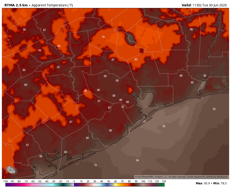
It’s an extremely muggy morning, with apparent temperatures near 90 degrees in Houston. (Weather Bell)
Tuesday
A few, light showers have popped up to the north of Houston this morning, but we expect these to be transient. Thanks to a southerly wind gusting up to 25mph, moisture continues to pump into the region, and this should keep our skies partly to mostly cloudy today. In turn, these clouds will limit high temperatures today to the low 90s. These clouds will also make for another very warm night, with overnight lows unlikely to fall below 80 degrees for most of the area.
Wednesday
A similar day to Tuesday in terms of humidity and southerly winds. However, as high pressure continues to build over the region this should limit the ability of air to rise, and accordingly cut down on cloud cover. Highs will rise into the low- to mid-90s with non-existent rain chances. Additionally, we should see another plume of Saharan dust move into the region, although it will not be as thick as what we saw last Friday and Saturday.
After the unsettled nature of last week’s weather—from heavy rains to heavy dust—this week holds less intrigue. We’ll see plenty of heat and especially humidity, but likely little rain at least until next weekend.
Monday
Mostly cloudy skies this morning should give way to partly sunny conditions later today. Highs will reach about 90 degrees for most of the area. Perhaps the two most noticeable features will be winds, which may gust from the south at up to 25 mph, and the humidity. Dewpoint temperatures are incredibly sticky this morning, in the upper 70s. By this evening a new plume of Saharan dust will begin to spread across Texas, but it is not as thick as the dust that reached the region last Friday.
Tuesday
A similar day to Monday, with gusty southerly winds and a mix of sunshine and clouds. Highs will reach the low 90s, with rain chances near zero.
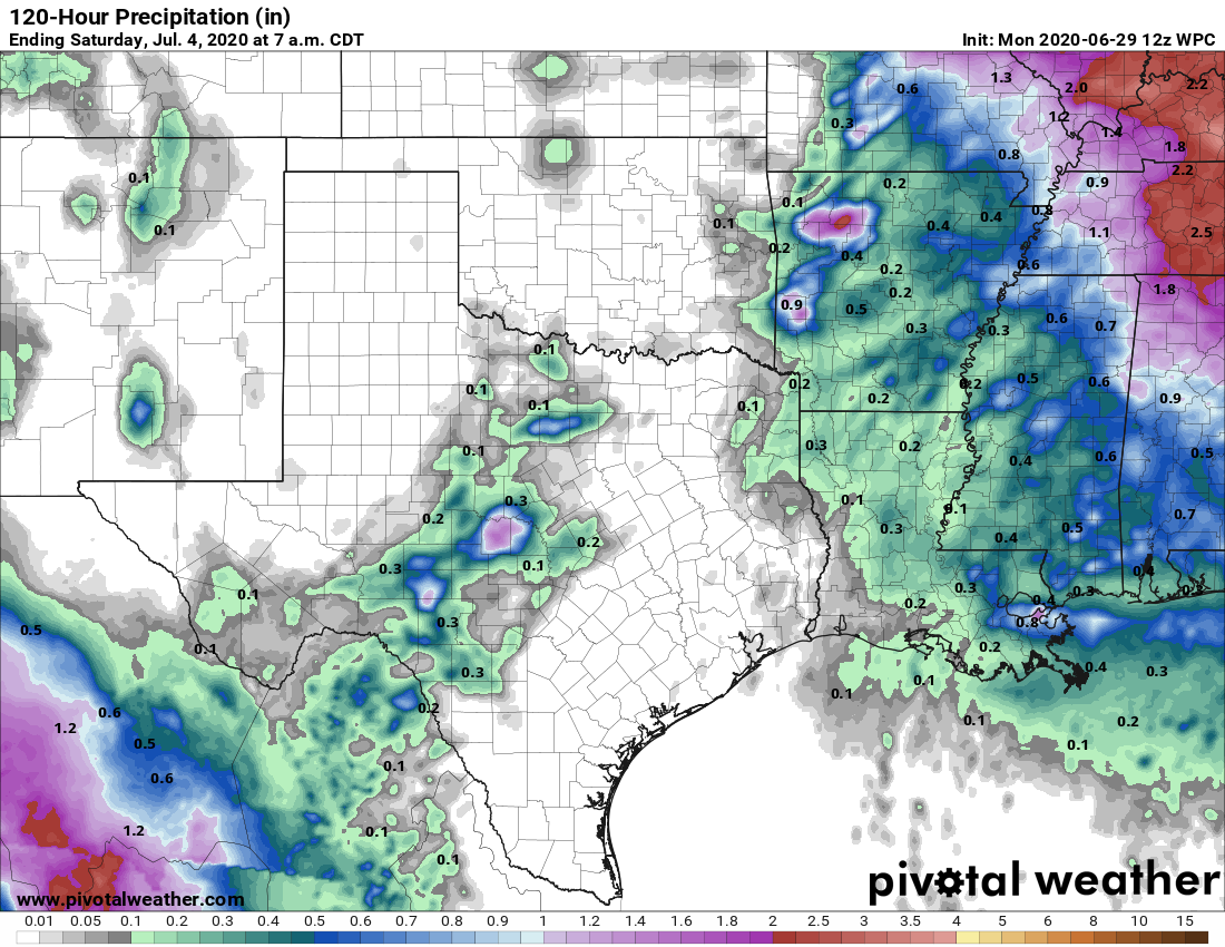
Virtually no rainfall is expected in Houston this week, through Friday. (Pivotal Weather)
Wednesday and Thursday
High pressure should really start assert control over our region’s weather. This will likely make for a pair of hot and sunny days, with temperatures in the mid-90s.
Friday
High pressure will begin to back off slightly, but it may not be immediately recognizable in our weather. Expect another hot and sunny day with highs in the mid-90s. Some additional moisture may push in from the Gulf of Mexico, so there may be a slight chance of showers during the afternoon—but probably not.
Saharan dust just began to infiltrate the Houston area yesterday, and it was not yet thick enough to obscure the sunset, which proved to be a real treat in spots.
Your sunrise and sunset mileage during dust events will certainly vary. Should the clouds clear, we expect thick dust today, but it may begin to disperse somewhat toward sunset, so there’s a chance we end up doing well. I think sunrise on Saturday may be fairly nice as well.
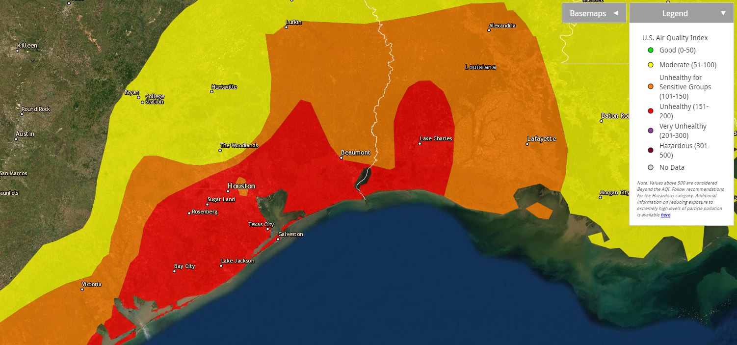
Aside from optical treats, there are practical issues with Saharan dust. The Texas Commission on Environmental Quality is forecasting today to be “unhealthy for sensitive groups” in the Houston area. Per the EPA air quality maps, we’re already one notch above that and “unhealthy” in much of the southeast half of the region.
Air quality is already considered “unhealthy” across the region today. It will improve gradually this weekend. (EPA)
If you have allergies, asthma, or other respiratory ailments, you will probably prefer to spend the better part of today indoors. Air quality should be improved a little bit tomorrow, though still probably considered poor. Sunday will be a little better than that.
As far as the rest of the weather goes….
Today
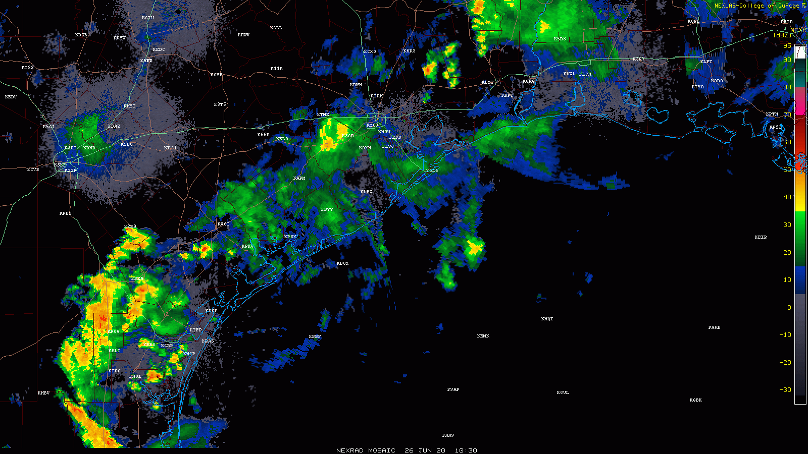
Radar is quiet for a change in the Houston area this morning, aside from a few light showers here and there. There are some storms north of Beaumont and some locally heavy rains in the Victoria area, with just nuisance showers in between.
Radar this morning shows heavier rains well off to our south and west. West of Katy has better odds of storms today than in or east of Houston. (College of DuPage)
Expect the heavier rains to our south and west to continue down there and lift northward today. This should keep those west of the Houston area and west of the hardest hit areas yesterday morning. While we could still see a few downpours or thunderstorms today, the focus will likely be between San Antonio and Columbus. If that should change, we’ll let you know. Yes, you might see some dust or “mud” residue on outside surfaces if it rains. Maybe. Rain would also help improve air quality.
With clouds, haze, or dust, don’t expect much in the way of true sunshine today. Highs will be in the 80s.
Weekend
Both Saturday and Sunday will feature a chance at a shower or thunderstorm. There may be a few small pockets where rain moves slowly and falls heavily for a time. So while many of us may not see much of anything this weekend, it’s not out of the question that a few neighborhoods end up with a couple inches of rain in a short time. I might give an edge to Sunday for having a higher rain chance, but both days will be setup for a few storms. Outside of that, expect a mix of clouds and sun with highs around 90, give or take a couple degrees and lows in the upper 70s.
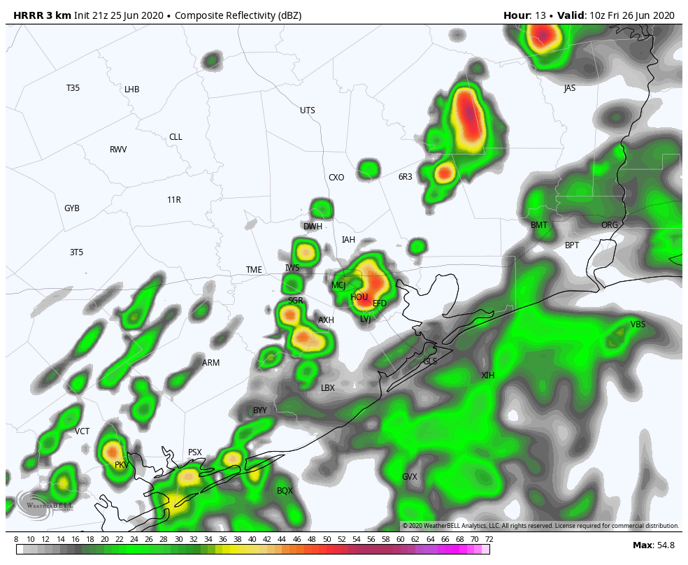
Good evening. We wanted to apprise you of the latest we have for the overnight forecast. Some storms remain to the west and north of Houston as of 6pm CT, but these should wind down during the next couple of hours. Unlike the previous two nights, as of now we do not anticipate any widespread showers or heavy rainfall on Thursday night or the wee hours of Friday morning.
However, the forecast models suggest a deeper area of moisture will push inland near Matagorda Bay or Galveston a couple of hours before sunrise on Friday, and this should bring some additional showers and thunderstorms into Houston throughout the morning. We don’t expect anything too extreme from these storms, with most people seeing 1-2 inches of rain at most.
HRRR model forecast for radar reflectivity at 5am CT Friday. (Weather Bell)
Obviously we’ll have a better handle on Friday’s weather by tomorrow morning, when Matt provides you with an update. But I wanted to let you know that—knock on wood—most of tonight should be relatively sedate for the Houston area, weather wise. It would certainly make for a nice change. And yes, we hope we’re not eating these words tomorrow morning.