The story of this week’s weather continues to be the heat. On Monday, Houston had its warmest day in eight months. The official high of 94 degrees at Bush Intercontinental Airport was the hottest temperature since September 16, 2019. Last year, the first day of temperatures reaching 94 degrees or higher came on June 1. In any case, summer has arrived in Houston.
Tuesday
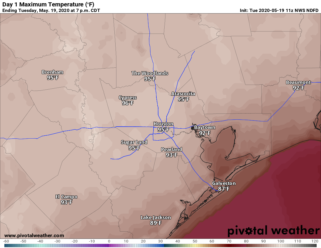
If you liked Monday’s heat you’ll love today. With high pressure still firmly in place, and mostly sunny skies, we can expect highs to top Monday by a few degrees. ( The record high temperature for May 19 in Houston is 95 degrees.) Humidity levels remain a bit lower than normal, and while this will help the air heat up faster, the slightly drier air will also help rein in the heat index this afternoon.
Welcome to summer, Houston. Here are Tuesday’s forecast highs. (Pivotal Weather)
As hot as temperatures will be today—and we’ll be running a good 8 to 10 degrees above “normal” highs on Tuesday—there should be just enough dry air hanging around to make for a pleasant evening as the sun goes down. Low temperatures tonight should drop into the low 70s.
Wednesday
As winds shift from the southwest to the south, we’re going to see the formation of some clouds on Tuesday night, and some of these should linger into Wednesday. This will also mark the return of more characteristic humidity for Houston, and this in turn should limit highs into the low- to mid-90s.
Houston will experience warm daytime conditions this week, especially through Wednesday as highs push up into the low- or even mid-90s, under sunny skies and the influence of high pressure and slightly drier air. The upside of this is that nights to start the week should see lows dip into the upper 60s for everywhere but the coast. Rain chances probably will not return until Friday at the earliest.
Monday
After starting out just below 70 degrees, highs today should climb into the low 90s for most of the region with very light, westerly winds. Skies will be sunny so we’re pretty much guaranteed a spectacular sunset for the metro area. Low temperatures on Monday night should be similar to Sunday night—which is to say quite pleasant for this time of year with the drier air allowing for a more rapid drop as the sun dips below the horizon.
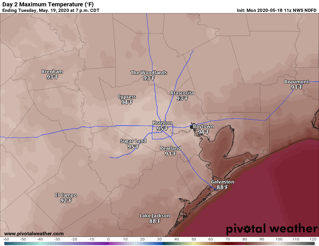
Tuesday’s high temperatures should be the warmest so far of this year. (Pivotal Weather)
Tuesday
This probably will be the warmest day of the week with a warm southwesterly flow and just enough dry air left for temperatures to really pop during the afternoon hours. Expect highs in the mid-90s for much of the city, almost certainly the warmest weather we’ve seen in 2020. Houston’s record high for May 19 is 95 degrees, which is definitely in reach. Make sure to take precautions when outside for extended periods of time.
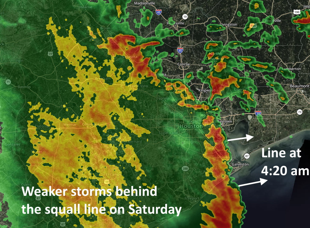
Good morning. After Friday’s unexpectedly widespread storms—with flash flooding in areas such as League City, Seabrook, Kemah, and elsewhere—conditions early Saturday are going more to form. A fairly strong squall line with gusty winds and briefly intense rainfall has pushed through most of the metro area as of 4:30am CT, and it should be well east of the metro area by sunrise. It has generally dropped 0.25 to 0.75 inches of rain.
This should be the worst of the region’s weather, but the upper-level low pressure system we’ve been talking about remains just to the north of our region. This should continue to drive showers and possibly some thunderstorms through the morning hours and into the early afternoon hours. These storms that develop should be weaker and less widespread as they move from west to east. Accumulations following the squall line’s passage should be less than one inch for most parts of the metro area today.
Annotated radar image at 4:20am CT Saturday. (kktv.com)
A lesser chance of showers and storms will persist through the overnight hours and into Sunday. The greater likelihood of development will be over Montgomery County and points north, away from the coast and areas hardest hit on Friday. Sunday should see partly sunny skies in addition to the possibility of some occasional light to moderate showers.
By Monday the drier air should take effect leading to sunnier days and clear nights. This should have the effect of dropping lows into the upper 60s, making for quite pleasant evenings and mornings. Our advice is to enjoy the relatively low humidity while it lasts.
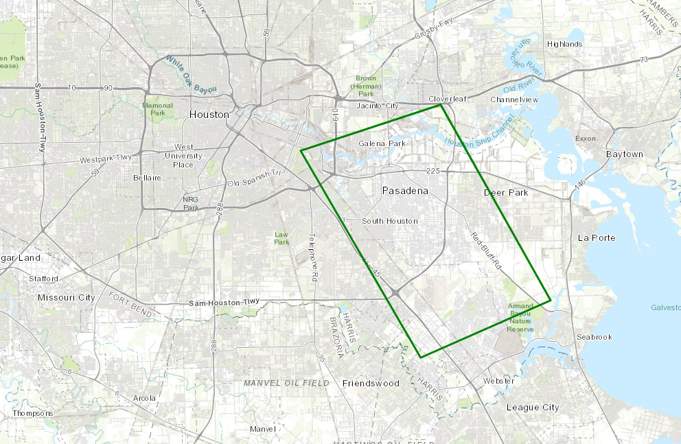
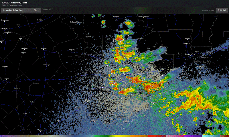
Storms this afternoon were expected to dump heavy rain in a few small areas around the region. What we are seeing is something more robust than that, as widespread heavy rain and some areas of street flooding are ongoing. Flood Advisories are posted for the entire Houston area, and the Pasadena area is now under a Flash Flood Warning through 5:15 PM.
Areas south and east of Houston, including Pasadena have been hardest hit by heavy rain, and a flash flood warning is posted until 5:15 PM there. (NOAA)
Radar as of 3:15 PM shows a cluster of heavy rain that has migrated west over most of the Houston area.
Radar shows widespread heavy storms in the Houston metro area, with the heaviest rain south and east of the city and also migrating westward. (RadarScope)
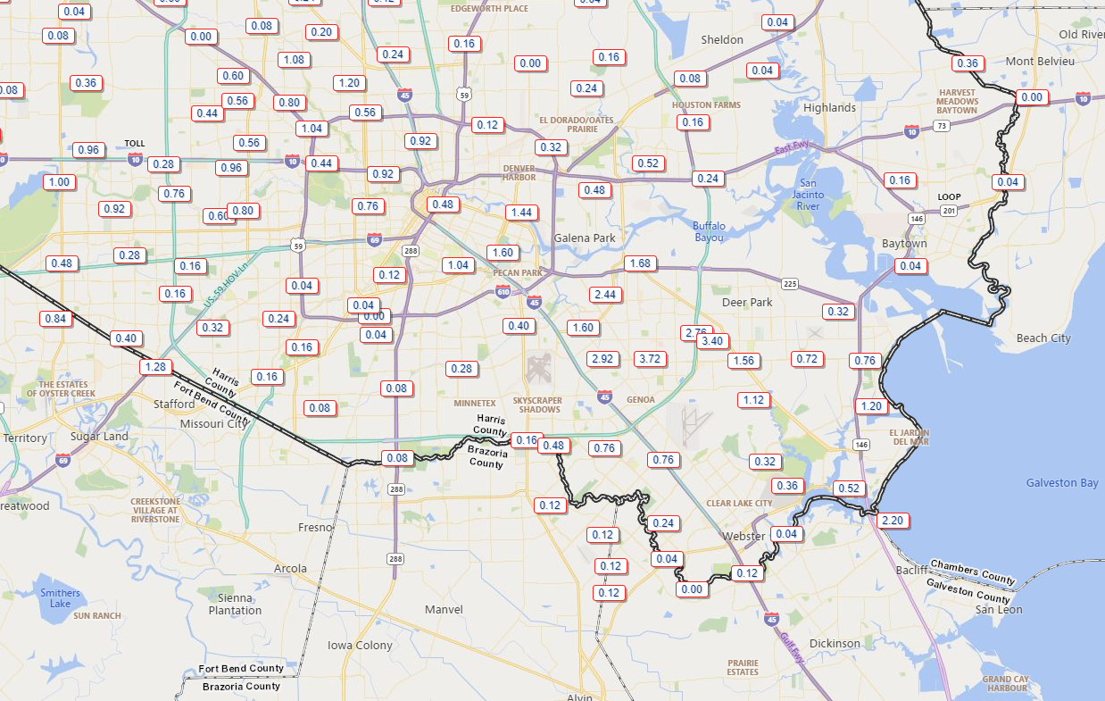
This is basically going to need to rain itself out now over the next 3 to 4 hours. Pasadena has been fairly hard hit with nearly 4 inches of rain so far.
Rain totals of nearly 4 inches have occurred so far today near Pasadena. It is still pouring there. (Harris County Flood Control)
For the sake of simplicity I’ve just shown part of the metro area above. You can always check rain totals over various times over the larger area at the fantastic Harris County Flood Control gage site. Some folks will see little to no rain (especially northeast of IAH Airport and perhaps well south toward Lake Jackson and Freeport). Others may tally 5 to 6 inches or more when all is said and done this afternoon.
So heavy rain, storms, and street flooding are likely in many spots through 7 PM. Storms will fade after that. We enter a quiet period later this evening and into the early overnight.
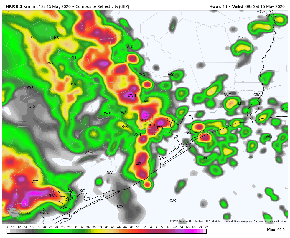
Round 2 of storms will arrive here later in the overnight. The timing of the next wave of storms has sped up since this morning, and it now appears we will see heavy rain and storms resume after 2-3 AM (about 2 to 3 hours faster than expected this morning). Below is what one model thinks radar will look like at 3 AM Saturday.
The HRRR model suggests a large cluster of heavy thunderstorms will plow through the region between 2 and 5 AM Saturday. (Weather Bell)
Other models vary a bit on timing and orientation, but all show the entirety of the region seeing a period of heavy rainfall. Another 1 to 3 inches of rain will be possible with this. This would likely lead to widespread street flooding, especially around the hardest hit areas so far with today’s rains, where the ground will be very saturated.
As for Saturday afternoon? There is a chance we see another round of rain and storms, but we still do not have much confidence in details yet to determine whether we need to be concerned or not. We will update you either tonight or early Saturday morning. A reminder that we went with a Stage 1 on our Flood Scale this morning. See our earlier post for more details on that. Stay safe, and remember to never drive through flooded roadways.