Good morning. Temperatures this morning have only fallen to around 70 degrees, markedly warmer than recent days. However, the ascent of our daytime temperatures will be slowed this week—we should stay comfortably in the 80s rather than going up to 90 degrees—by decent rain chances and the possibility of storms. A fairly potent upper-level low pressure system could bring heavy rainfall to the region this weekend, but unfortunately we’re lacking details for a more precise forecast.
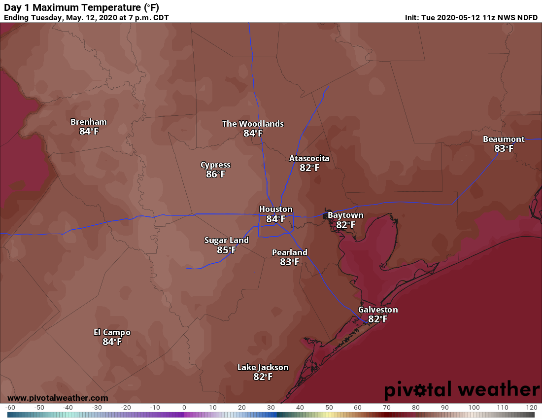
High temperatures Tuesday should reach the mid-80s. (Pivotal Weather)
Tuesday
A line of storms just west of Interstate 35 this morning should steadily move west toward Houston today. The question is how much moisture they will have to work with as they move into our region. Rain chances this afternoon appear best to the west and northwest of Houston, in areas such as Sealy, College Station, and Brenham. But I think it’s definitely possible that some of these storms hold together as they move into the Houston area later this afternoon or during the evening. Briefly heavy rain and strong wind gusts will be possible. Rain chances for the region will be on the order of 20 to 30 percent. High temperatures should climb into the mid-80s under partly to mostly sunny skies.
Wednesday
Right now Wednesday appears to be similar in nature to Tuesday, although any afternoon storms that fire up will likely be less organized. Expect highs in the mid-80s, with partly to mostly sunny skies.
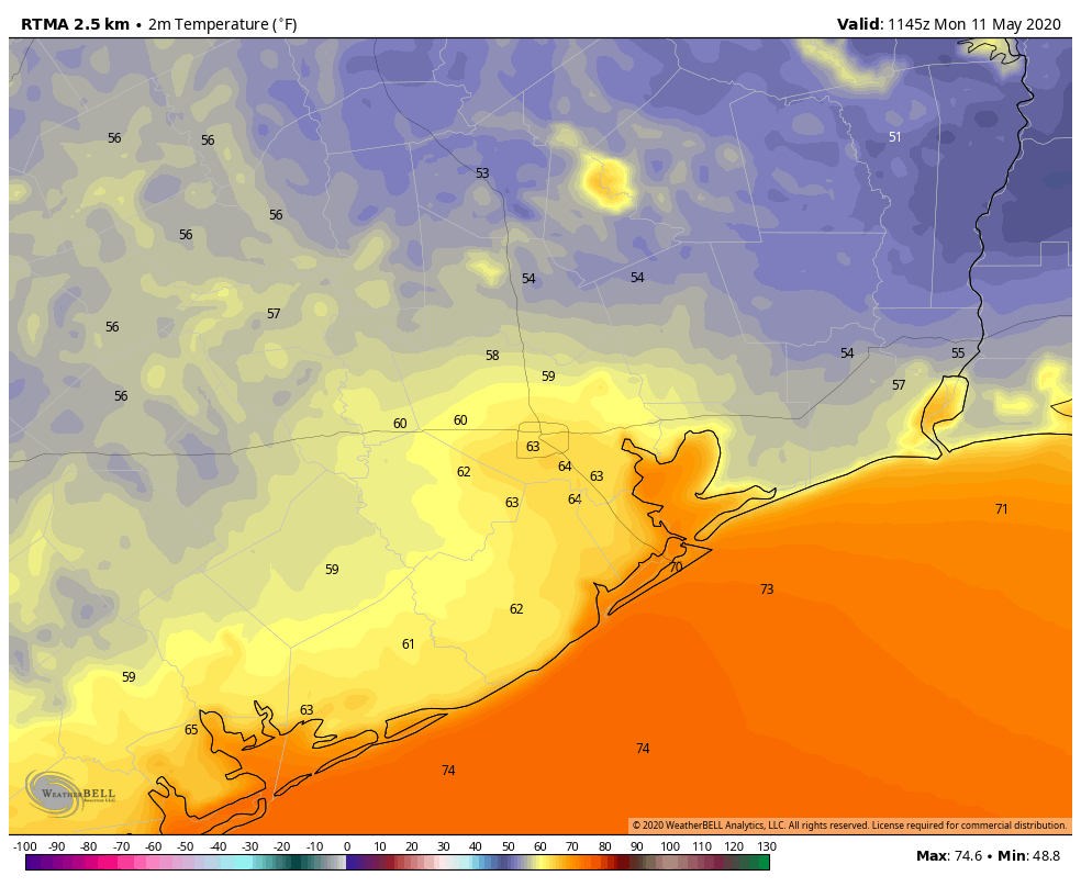
Good morning. It’s another cool start to the day—for May, at least—with lows dropping into the upper 50s for the northern half of the region. I hate to write this, but this is probably much of the region’s last flirtation with the 50s for at least four months. After this weekend’s sublime weather we’re not going to jump into full-blown summer this week, but we definitely will see humidity, warmer days, and warmer nights. In short, it will feel a lot like May.
Temperatures at sunrise on Monday were delightful. (Weather Bell)
Monday
As high pressure moves away from the region today, winds will shift to come from offshore, and this will begin the process of raising humidity levels and temperatures this week. Even so, Monday should still be quite a nice day, with highs limited to the low- to mid-80s and partly to mostly sunny skies. Rain chances are near zero. Winds should remain light as they come from the southeast. Clouds will build later this afternoon, or during the evening, making for a mostly cloudy night. Lows in the coastal area probably won’t drop below 70 degrees, but inland areas should see the 60s.
Tuesday
We should see a mix of clouds and sunshine on Tuesday, as high temperatures nudge up into the mid-80s. An atmospheric disturbance will traverse the area from west to east later on Tuesday, bringing a slight chance of showers and thunderstorms during the afternoon. But mostly this should be a typical late-spring day with highs in the mid-80s, and lows dropping to around 70 degrees.
After a pair of pretty nice days across Southeast Texas, we’re waking up to a warm, humid, mostly gray one today. But that will change. For those of you looking for last hurrah of really comfortable weather before summer, soak up this weekend.
Today & tonight
The region has had some gusty onshore winds overnight. Galveston has seen some wind gusts close to 40 mph since 2 AM, while inland locations have seen 25 to 30 mph gusts at times. Winds should diminish a bit through the day today before picking back up from the offshore direction tonight.
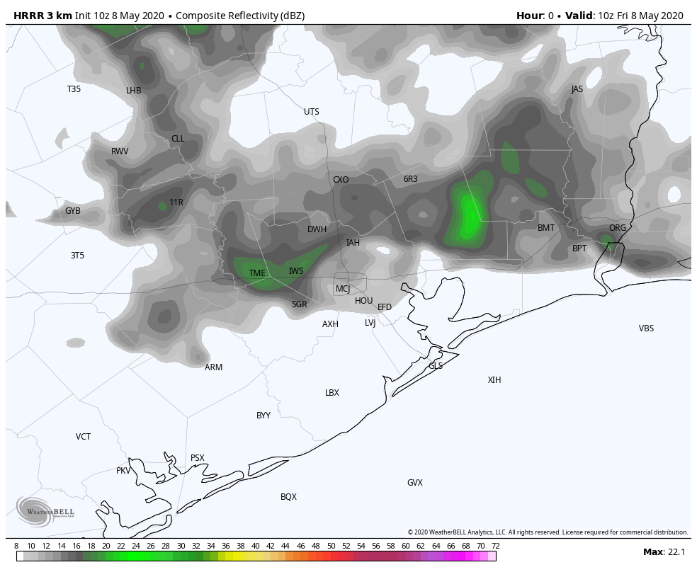
As far as weather, we’ll call it cloudy this morning. We may see more sunshine break out by late morning or afternoon, and it will remain warm to hot and humid. While a few showers or sprinkles could occur this morning, most of us will probably stay dry. The cold front itself will approach the region this afternoon. Right now, we’re expecting a broken, disorganized line of showers and a couple storms to drop into the northern suburbs 1-2 PM this afternoon. The storms may become better organized and cover more territory as they move through Houston proper and south of I-10 toward the coast late this afternoon.
Here is how one model (the HRRR) forecasts rain chances through the day, ending at 8 PM. A “line” of showers moves through Houston after 2 PM, becoming slightly better organized and heavier south of I-10 and near the coast toward evening. (Weather Bell)
Temperatures should drop from the upper-80s or near 90° back into the 70s behind the showers.
Severe weather via strong wind gusts and hail can’t be entirely ruled out today, but that risk has diminished a bit, and we expect any severe storms would be very isolated and mainly south and east of Houston.
By about 8 PM, most of the storms should be out of the immediate Houston area, but some showers and storms may still be ongoing for places like Lake Jackson or Matagorda. The front will continue to slowly push offshore this evening. However, showers will likely linger into the overnight for those areas south of Houston and Galveston, particularly toward Matagorda, maybe Freeport. Otherwise, it will just be mostly cloudy and breezy overnight. And it will turn much cooler.
Overnight lows tonight should bottom in the lower 60s for many, 50s for some. It will feel much cooler Saturday morning, along with a breeze. (Pivotal Weather)
Overnight lows tonight will bottom out from the lower-60s in much of the area and south of I-10 to the upper-50s to the north. Along with that breeze, it will feel quite cool late tonight and Saturday morning.
Saturday
With a good deal of clouds around much of Saturday morning and an abnormally cold air mass for May dominating the eastern half of the U.S., we’ll likely limp into the mid-70s Saturday afternoon. Those temperatures would be a solid 10 degrees below normal for this time of year. More sun is likely as the day goes on, especially for folks north of I-10.
Along with cool temperatures, expect a pretty steady, gusty offshore breeze. Winds over Galveston Bay will probably peak around 20 to 25 mph or so.
Mother’s Day
Stunning. Sunshine, comfortable humidity, comfortable temperatures. Look for a morning in the 50s to near 60 degrees and an afternoon in the upper-70s to near 80°, along with light winds. Thanks to all the mothers out there for all that they do for the world, and an apology to my mom in New Jersey who will be waking up to 30s on Sunday morning.
Good morning. After a wonderful Wednesday we will see one more sunny day before a potentially stormy Friday. The inclement weather on Friday should lead to a spectacular spring weekend for May, with sunshine and highs possibly in the 70s for both days and abundant dry air. If you missed our weekly Weather Wednesday video yesterday, you can find it on YouTube.
Thursday
After starting out with temperatures in the mid-60s this morning, the script for today calls for highs to warm into the low- to mid-80s. Winds will shift to come from the south later today, and may become a bit gusty, up to about 20mph. Clouds will begin to return later this afternoon, or during the overnight hours, and this combined with returning moisture will keep low temperatures from dropping below the low 70s for the metro area.
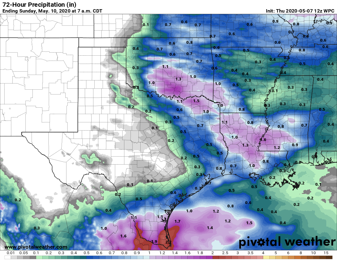
NOAA rain accumulation forecast for now through Saturday. (Pivotal Weather)
Friday
Our increasingly warm weather will be shaken up on Friday by the arrival of a cold front that should push through Houston from the northwest to southeast during the afternoon and evening hours. Right now it appears this will start out as a thin, broken line of showers that may intensify as it moves toward the coast. Once the front hits the sea breeze, some stronger thunderstorms may flare up in central and southern parts of the region. There is a slight risk for severe weather in the form of hail and damaging winds.
Another facet of this front is that it is going to move fairly rapidly until it doesn’t. This means that at some point, probably near or just off the coast, it’s going to stall for a bit. Right now we think that probably allows showers to linger for a bit during the overnight hours on Friday along the coast.