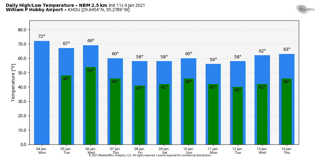
Good morning. Houston will now see a couple of warmer days—with temperatures peaking in the low to mid-70s—before colder, winter-like weather returns. We then may see a sustained stretch of truly colder weather (for Houston, at least) with several days during which high temperatures do not climb out of the 50s. If you have been waiting for winter proper, it appears to be at hand for Houston.
Monday
Some central parts of Houston are seeing a thin layer of fog develop, but this should burn off fairly quickly after sunrise. High pressure will continue to drive our weather, and this will lead to a mostly sunny day with high temperatures likely reaching into the low- to mid-70s for most of the area. A few clouds will develop tonight, as temperatures fall into the 40s for most of the area except for the immediate coast.
Tuesday
We’ll see another sunny day, with high temperatures likely reaching about 70 degrees. Winds will start to come from the east, and then the southeast, and this will begin to slowly increase moisture levels and set the stage for some healthy rain chances on Wednesday. But there will be none of that on Tuesday, when we should see mostly sunny skies. As clouds begin to increase during the overnight hours, this should prevent lows from falling below the low 50s for most of the region.
Wednesday
The day should start cloudy, with a chance for scattered showers during the morning hours. A front should sweep through during the afternoon hours, from west to east, and most all of the area should see at least brief rainfall from these storms. Accumulations for most people should be less than 1 inch as the storms push through, but isolated areas may see a bit more than that, and some of these thunderstorms may be briefly intense. As the front clears the area during the late afternoon or evening hours, rain chances will end, and lows will drop into the 40s.
Thursday and Friday
After the front moves through we may see some breezy conditions overnight, but winds should begin to subside by Thursday and Friday. This will set the stage for a sunny, cool end to the work week. I’d expect highs in the upper 50s to about 60 degrees with lots of sunshine both days. Lows probably will drop to around 40 in the city of Houston.
Saturday, Sunday and beyond
So what does the weekend hold? Temperatures remain cold through Saturday, when we may see a few more clouds begin to develop. Sunday may see a bit of a warmup before another front approaches the area, but I think mostly cloudy skies will probably keep highs in the 50s. The timing and details with the next front are unclear, but it’s expected to bring another shot of rainfall and then quite a bit more colder air. We probably will see lows in the 30s next week, but it’s difficult to have much confidence in the details for now.