Good morning. Light winds and a fairly moist atmosphere have combined to produce widespread fog across the region, with visibilities down to one quarter mile or less in some areas. This should remain until mid-morning, before finally burning off. Please take care on roadways in the meantime.
Monday
After the fog dissipates, skies will be partly to mostly sunny today, with temperatures rising to around 80 degrees. Winds will come from the south later this afternoon as the front that moved through Houston on Sunday returns back onshore. This will also bring a slight chance of showers this afternoon for areas south of Interstate 10, with higher resolution models hinting at the possibility of some isolated thunderstorms. Lows tonight will only drop into the 60s as a warm, and fairly humid air mass returns to the area.
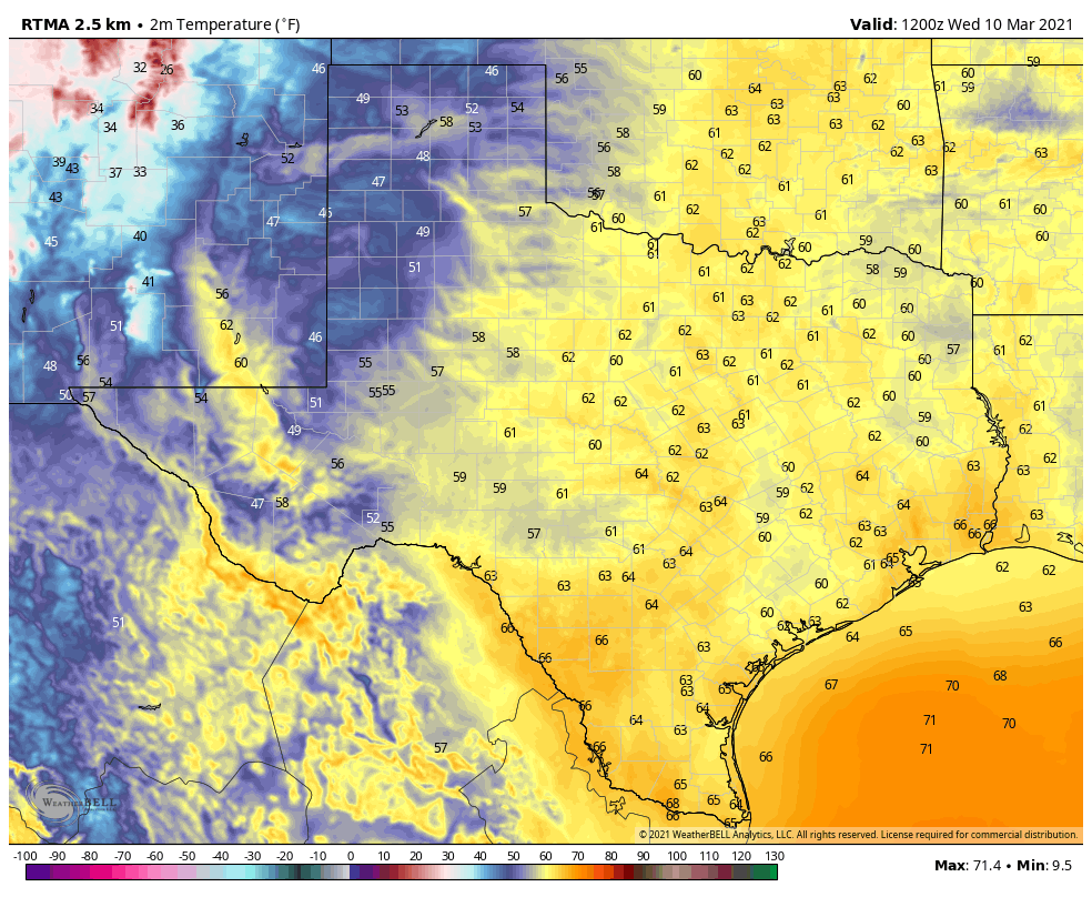
A colder airmass lies northwest of Houston this morning, but it’s not coming closer today.
Tuesday and Wednesday
Warm conditions remain on these days, with highs of around 80 degrees and mostly cloudy skies. A very few, light showers are possible Tuesday evening, but the better rain chances will come on Wednesday morning as a cold front approaches and moves through the area. Accumulations look modest, perhaps 0.25 inches to 0.5 inches of rain for most, give or take. Right now it looks like the front will push through during the late morning hours of Wednesday, or by around noon. This should allow for clearing skies later in the day and a cooler night, with temperatures dropping to around 50 degrees.
Thursday and Friday
This will be a bonafide front and move more definitively offshore, and as a result we’ll see clear and cool weather. Look for highs around 70, and lows in the upper 40s to around 50 degrees, with clear skies to end the work week.
Friday night could be the coldest of the week for the region.
Saturday, Sunday and beyond
For now, it looks like the drier air will hold into much of the weekend, so we can probably expect partly to mostly sunny skies with highs in the low 70s and lows somewhere around 50 degrees. That sounds lovely, and we’ll hope that forecast holds.
Conditions will warm early next week before another front potentially moves through by Tuesday or Wednesday.
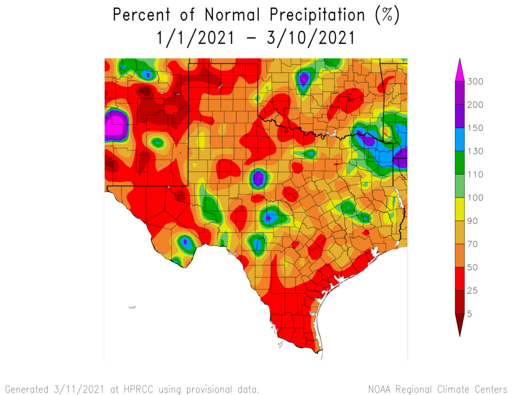
Good morning. A very quiet couple days are ahead for Houston, followed by a cold front on Sunday, which should hopefully bring us some rainfall. We are beginning to run into a bit of a precipitation deficit again. While most of the area is technically not in drought, we are once again seeing it expand in Texas. Within the Houston region, we have gone from 9 percent coverage of drought back at the end of February to 35 percent drought coverage as of yesterday’s update. Since the first of the year, our area has seen anywhere from 40 to 50 percent of normal rainfall (with the exception being north of Conroe).
Rainfall since the beginning of the year has been rather paltry in most of the region, leading us back toward drought for at least the third or fourth time since last spring. (High Plains Regional Climate Center)
We’ve seen this happen about three or four other times since last May, and some kind of weather system or slow moving front has bailed us out from devolving into serious drought. We’ll see if that happens again this time.
Today & Saturday
Fairly similar weather is on tap for today and tomorrow. Low clouds and fog are the story this morning. Visibility isn’t severely restricted in most spots (except perhaps along the immediate coast), but we’ve definitely shifted into a murkier look this morning. The pattern the next couple days will be similar with low clouds and fog in the morning, some partial afternoon clearing, and a slight chance of showers. Any rain would be very, very spotty, and it would be unlikely to amount to much more than a few minutes or few hundredths of an inch.
High temperatures should generally be in the 70s to perhaps low-80s, with lows in the 60s to perhaps close to 70 degrees in spots.
Sunday
The forecast for Sunday is both straightforward and tricky, if that makes sense. The overall theme for Sunday is very simple: A cold front will push through, probably in the late morning and early afternoon from northwest to southeast across the region. With it, some showers and thunderstorms but probably not a ton of rainfall. We expect a couple tenths to a quarter-inch or so, with maybe slightly higher amounts north.
Where it gets tricky on Sunday is with the temperature forecast. We should start off quite warm, in the 60s to low-70s. We’ll likely bump into the mid or even upper-70s before the front sweeps through, dropping temperatures a good 10 to 15 degrees. Models differ a good bit on how far those temperatures will drop, with some saying low-50s by afternoon and others in the upper-50s to low-60s. Either way, it will turn a good bit cooler in the afternoon on Sunday, so if you’ll be out and about, be ready.
It will also be breezy, with wind gusts of 20 to 25 mph at times on Sunday.
Next week
Sunday’s front will make it about 30 to 50 miles offshore before stalling on Monday. It should come back at us as a warm front later Monday and on Tuesday, bringing a chance of showers for some of us. Eventually, a stronger cold front will likely sweep through on Wednesday, bringing another chance of showers and storms, and then cooler air and nicer weather for the end of the week.
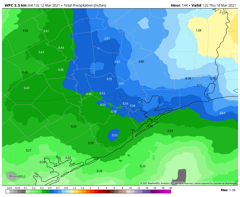
When all is said and done, we should see about a quarter to half-inch of rainfall between now and next Thursday morning, with at least some risk for higher amounts along or north of I-10. Some places, especially close to the coast may only receive a couple tenths of an inch. It will be unevenly beneficial for our region.
Total rainfall through Thursday morning from the NWS shows higher amounts as you go north. (Weather Bell)
Because of fronts coming at us in so many directions, temperatures will be a bit of a roller coaster ride next week. Look for low-50s Monday morning, 60s Tuesday morning, and possibly near 70 on Wednesday morning, before 40s and 50s return for later in the week. Daytime highs will offer just a little less whiplash, with near 80 or warmer on Monday and Tuesday, 70s on Wednesday depending on the exact timing of the front, and then lower-70s or even 60s on Thursday and Friday.
I have seen some continued comments and concerns about rumors of another freeze coming to Houston. That doesn’t seem to be in the cards. Certainly, late next week doesn’t look much worse than low-40s, and even that’s pretty aggressive. We may have another dose of cooler air another week after that, but no models show any risk of a freeze from that one either. We wouldn’t worry.
Good morning! As we get closer to the weekend our overall pattern remains more or less the same, with three more partly to mostly cloudy warm days, a transition day on Sunday, and somewhat cooler weather next week. Overall the forecast is pretty boring, and after last year’s hurricane season and the recent winter storm, there’s nothing wrong with that.
On an unrelated note, I’ll be speaking during a couple of free, online events today you may find of interest. I’ll be speaking virtually about LIFTOFF at a Houston Writer’s event at 1pm CT, and interviewed about the book for the San Francisco-based Commonwealth Club at 5pm CT. The YouTube link for the Commonwealth event will go live at that time.
It’s a warm, sticky morning across the Houston area on Thursday. (Weather Bell)
Thursday
Southerly winds will continue to blow, bringing more warm and humid air into the region. As a result, we expect continued, mostly cloudy skies today with high temperatures reaching around 80 degrees. Winds will again be noticeable out of the south, blowing as high as about 20 mph. Like Wednesday night, lows will only drop into the upper 60s for most.
Friday and Saturday
We’ll see more of the same on Friday and Saturday, although winds may slacken just a bit, and there may be a few more breaks in the clouds as sunshine peeks through. Look for highs to again hit about 80 degrees, with warm nights and plenty of humidity to spare. Rain chances will be about 10 percent both days.
Sunday
The pattern changes as a cold front pushes toward the region, and this will lead to better rain chances from the period of Saturday night into Sunday night. Most of these showers will be light, with accumulations of 0.25 to 0.5 inches for most, and skies should otherwise be cloudy. Highs will reach the mid-70s or so, and right now the front looks to move into the city during the afternoon or evening hours. This will set the stage for a cooler night, likely in the 50s.
Monday’s cooldown will be brief next week. (Weather Bell)
Next week
The front will cool things off for the region on Monday, but by Tuesday the pattern will again warm again. The forecast models now seem increasingly confident in a second front pushing through on Wednesday, which should drive highs into the 60s for the second half of next week, with lows in the 40s and 50s. Wednesday’s front should bring another splash of rain into the forecast, but nothing that looks too serious at this time.
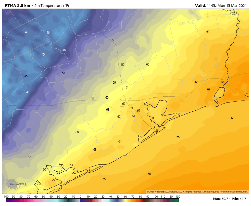
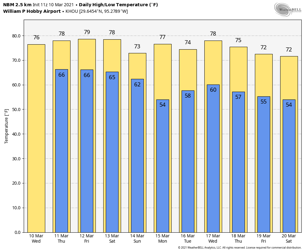
After several days of partly to mostly sunny skies, clouds are back on the menu for Houston, along with increasing levels of humidity. Temperatures across the region are unlikely to fall below the 60s for most areas until Sunday night, by which time a front should drop us back into more seasonable conditions.
It’s a warm morning across Texas for early March. (Weather Bell)
Wednesday
A much warmer, southerly flow is in place over the region, and as a result temperatures this morning have only fallen into the low- to mid-60s across the region. In response to fairly tight pressure gradients, we’ll see onshore winds kick up again this afternoon, with gusts reaching about 25 mph out of the southeast. This humid air will allow temperatures to reach into the upper 70s, to 80 degrees, despite cloudy skies. Overnight temperatures won’t fall below the mid- 60s.
Thursday
Our sensible weather won’t change much on Thursday, although slightly increased moisture levels may allow for some very scattered, very light rain showers to develop. Highs will again be near 80 degrees with mostly cloudy skies.
Friday and Saturday
The continued flow of warmer air will lead to more days with highs of around 80 degrees on Friday and Saturday, although we may see a little bit more sunshine during the afternoon hours. Nights will remain warm and sticky, with the possibility of fog developing along and near the coast as warmer air moves over cooler shelf waters.
Sunday
At some point on Sunday our next cold front should arrive in Houston. For most of the day, however, we may see gray skies and fairly decent rain chances, with accumulations perhaps on the order of 0.25 to 0.5 inches. There may be a few thunderstorms. Highs likely will be the 70s, with a cooler night as lows drop to around 50 degrees in Houston.
Conditions will turn cooler next week. But how cool, and for how long? (Weather Bell)
Next week
The first several days of next week look cooler, but the global models seem undecided about whether a second, reinforcing front will make it through by around Wednesday. As a result, we don’t really know whether highs will be in the 60s or 80s for the second half of next week.