Houston’s weather: Spring-like and pretty dull. Which is great.

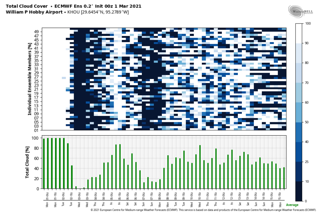
Houston’s weather now turns rather boring—and since we’re in March that means good things like dry air and moderate temperatures—so there’s not a whole lot to say about the forecast. Overall, expect some great Spring weather in the days ahead.

Temperatures near sunrise on Wednesday morning across Texas. (Weather Bell)

Wednesday

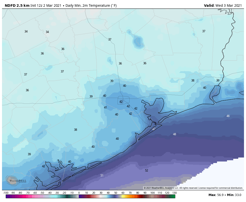
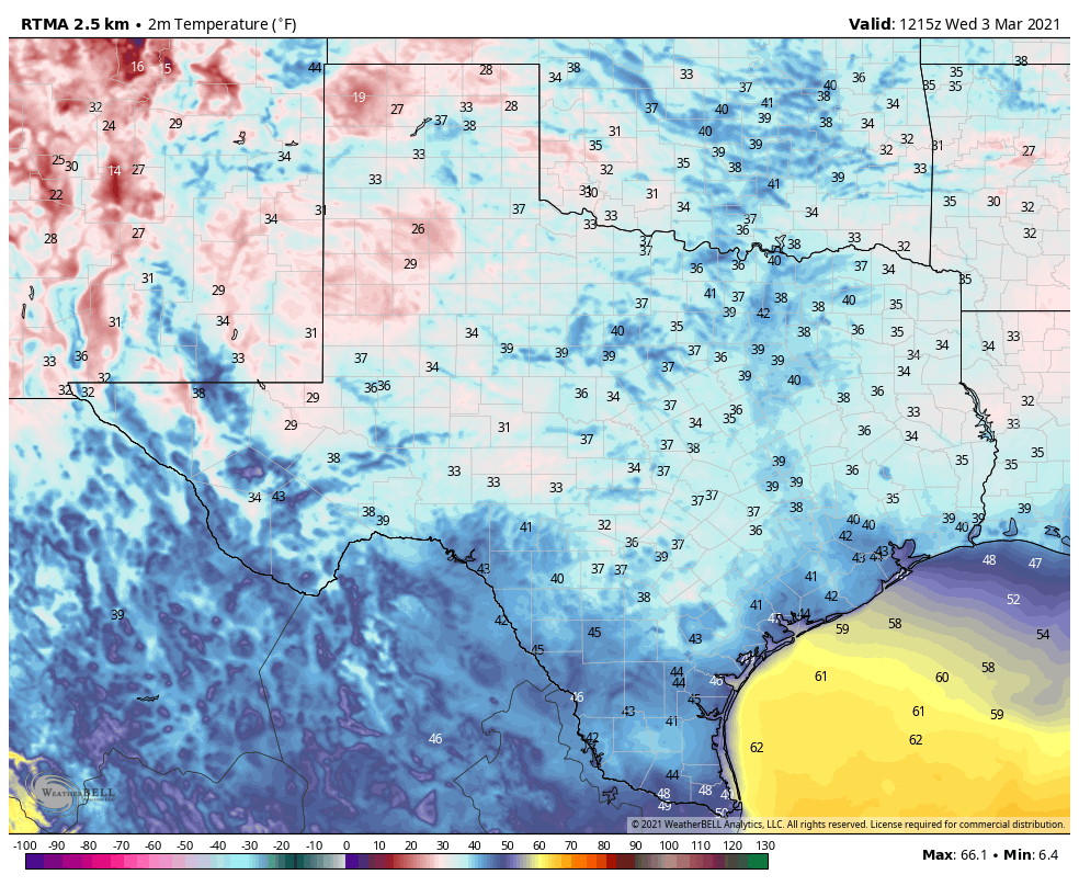
We’re starting out mostly in the 40s this morning, with some areas far inland touching the upper 30s. Conditions will quickly warm today with sunny skies, and we can expect highs in the upper 60s to 70 degrees. Slight winds are currently from the east, and they will move to come from the southeast later today. We’ll see one more chilly night, with temperatures dropping to similar levels tonight as Tuesday night.

Thursday

Expect another brilliantly sunny day, with highs again near or at about 70 degrees. There will be a bit more humidity with light southeasterly winds in place, and accordingly lows will only drop into the 50s on Thursday night.

Friday

We’ll see partly to mostly cloudy skies on Friday, and highs should work themselves into the lower 70s. Some scattered, light showers may develop during the afternoon hours as a moderate cool front approaches, and moves through the area. Lows Friday night will drop into the 50s.

Rain chances are slightly better east of Houston on Friday. (Weather Bell)

Saturday and Sunday

The weekend still looks great, with partly to mostly sunny skies and highs generally in the upper 60s or so. Saturday night will be a tad cooler, with lows dropping into the 40s, and slightly warmer on Sunday night.

Next week

After this weekend our weather will see a warming trend, and I would not be surprised to see temperatures hit the 80-degree mark by the middle of next week. At that point another cool front will approach, but it’s not yet clear whether this front will make it all the way to the coast, or even close enough to Houston to produce rain showers. That’s something to worry about for another day. For now, we can simply enjoy the weather.

Looking back at Houston’s wild February, and what spring holds

A quick note before we jump into the weather: My book on the origins of SpaceX, LIFTOFF, is available in bookstores everywhere today. It has received tremendous reviews so far, and I could not be more excited to share this remarkable story with the world. I must say, I put pretty much everything I had into reporting and writing this book. Ok, now on to the weather.

February was quite the month of weather for our region, with a fairly warm start, an extremely cold middle 10 days of the month, and a rather warm ending. Overall, February, 2021, will rank as about the 20th coldest February on record in the city of Houston over the last 140 years or so. The bar chart of daily temperatures, with record lows on February 15 and 16, is something else:

Graph showing a very warm start and end to February, with chills in between. (National Weather Service)

So what comes next? Although La Niña—a cooling of the tropical Pacific Ocean—peaked at the end of 2020, we do remain in a moderate pattern. Although La Niña is weakening, we likely will see its effect through much of the spring, and for Texas that generally should mean warmer and drier conditions. I’ve looked at the various global and seasonal model forecasts for March, April, and May, and pretty much all of them align with this idea. So, too, does NOAA’s seasonal forecast for spring, which shows nearly all of the Lower 48 states seeing warmer than normal conditions.

Temperature outlook for March, April, and May. (NOAA)

What this all means is that spring is upon us, and pretty soon we are likely to see highs in the 70s and 80s with some regularity. The chances of a freeze for anywhere in Houston, and surrounding areas, is rapidly diminishing to near zero. A week ago, lows were in the 20s. Soon, our nights in the 40s will become increasingly rare.

Tuesday

After much of the Houston region picked up 0.5 to 1.0 inch of rain overnight, the bulk of the precipitation has shifted eastward. Drier, and at-times gusty northerly winds will clear clouds out of the area later today, and temperatures should rise from the upper 40s to around 60 degrees. Temperatures tonight will drop to around 40 degrees, and this will be the coldest night of the week as clear skies prevail.

Wednesday and Thursday

These will be a pair of splendid, mostly sunny days. Highs will likely get into the mid- or upper-60s on both days. Winds will shift to come from offshore later on Wednesday or Wednesday night, so lows will nudge into the mid-40s on Wednesday night, and likely won’t drop below the 50s on Thursday night.

Wednesday morning will be the coldest of the week. (Weather Bell)

Friday

Friday will be warmer and a bit muggier, with temperatures likely to reach about 70 degrees. A frontal passage later on Friday, during the afternoon or evening most likely, may generate some rain showers although there won’t be that much moisture in the atmosphere to work with. Temperatures on Friday night should drop into the 50s.

Saturday, Sunday, and beyond

The weekend still looks pretty tremendous. We expect to see partly to mostly sunny skies, dry air, and highs somewhere in the mid- to upper-60s for the most part. Lows will likely drop down into the 50s—perhaps upper 40s for inland areas. Really, this should be just a great, great spring weekend for doing whatever you need to do around the area.

Most of next week should be warmer and more humid, with highs generally in the 70s, and lows likely around 60 degrees. Days should bring a mix of sunshine and clouds, with some better rain chances returning by Wednesday or Thursday, give or take. As we said, spring is descending upon Houston and looks to stay for awhile.

Houston to see more sunshine, dry air this week

Good morning. Before jumping in to the forecast, I wanted to briefly talk about the recent sharp cold snap Houston experienced, and its effects on mosquitoes. Unlike a regular freeze, widespread temperatures in the teens may have some significant effect on populations. A recent study found that temperatures below 20 degrees Fahrenheit significantly reduced the number of viable larvae, as only eggs laid in well insulated areas will survive.

This will not wipe out the population, but it should put a dent in their numbers this spring. For how long? Scientists say a wet and warm spring could bring populations back to near normal later this summer. As for conditions in Houston this spring, we’ll have an outlook for you tomorrow.

Monday

A cold front is slogging through Houston this morning, and if you’re inland of Interstate 69 you’re already beginning to feel its effects. But if you live closer to the coast, its passage won’t come for a few more hours as the front probably won’t move offshore until shortly after noon. Behind the front, temperatures today will be in the 50s for inland areas, and after the front passes, in the low 60s for coastal areas.

The other notable feature today will be increasing rain chances from around noon through the evening hours. This will offer a reasonably good soaking for the area, with 0.25 to 1.0 inch for most of the Houston metro area—with higher isolated amounts—and the potential for 2.0 or more inches north of Highway 105. Rains will generally end tonight or by early Tuesday. Lows Monday night should drop into the upper 40s away from the coast.

Tuesday night should be the coldest of the week.

Tuesday

A colder day, with highs near 60. Winds will remain consistently out of the north at about 10 to 15 mph, but skies should begin to clear during the afternoon hours. With clearing skies, we can expect Tuesday night to be the coldest of the week, with lows dropping to around 40 degrees, give or take.

Wednesday and Thursday

The middle of this week looks pleasant, with highs in the 60s to 70 degrees and lots of sunshine. Lows by Thursday night probably will only drop into the 50s.

Friday

An atmospheric disturbance may lead to some increased rain chances as clouds return on Friday, but right now we’re not expecting to get too wet. Highs on Friday should be around 70 degrees, with a front pushing through overnight.

We expect mostly sunny skies for most of the coming weekend.

Saturday, Sunday, and beyond

Assuming the front makes it through as anticipated, this weekend should see mostly sunny conditions with highs in the 60s and lows in the 40s and 50s. At this point, the weekend does look rather grand for early spring so perhaps make some tentative outdoor plans now. We should see a warming trend heading into next week.