Nicholas becomes a hurricane, will batter coast, and bring heavy rains south of Houston tonight

‘Twas the night before Tuesday, when all through the city
None were stirring, not even Harry Styles more’s the pity;
Dry stockings were hung by the chimney with care,
In hopes that St. Nicholas soon would not be there.

Alas, Nicholas is here. And he’s bringing lumps of coal for all. So we’d better discuss the forecast.

As of 10 pm CT, the National Hurricane Center says Nicholas has become a hurricane with 75-mph winds. Its center is presently located 20 miles southeast of Matagorda, Texas. The storm is moving to the north-northeast at 10 mph, and should come ashore the upper Texas coast later tonight, possibly near Sargent, Texas. No additional strengthening is anticipated, the hurricane center says. The storm is expected to cross the Houston region on Tuesday morning and then move into southeastern Louisiana and essentially stall before dissipating by Thursday or so.
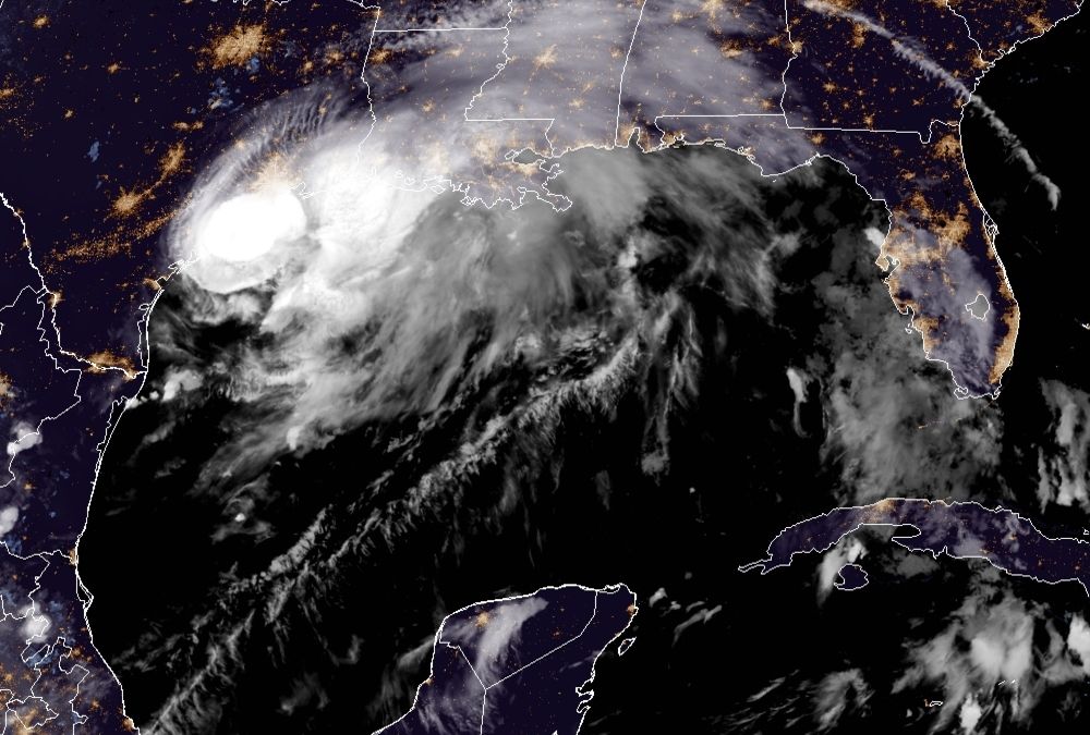
Satellite appearance of Hurricane Nicholas at 10 pm CT. (NOAA)

Houston area rainfall

Our overall rainfall forecast remains largely unchanged. If you live inland of Highway 59 and Interstate 10, you’re very likely to miss out on heavy rainfall overnight and into Tuesday morning. My expectation would be for 2 inches, or less. If you live closer to the coast, particularly in Brazoria, Galveston, and Chambers counties, heavy rainfall is much more likely. Widespread totals of 4 to 8 inches are likely, with bullseyes of 10 inches or more that may produce localized flooding.

The radar image below tells the tale of the night. We can see the main band of thunderstorms along the Texas coast, but mostly offshore. This band of gnarly storms will to move to the northeast tonight, and how bad things get for the Texas coast will depend on how far inland it gets (or how far offshore it remains). Right now I’d be surprised if the heaviest rains pushed much farther inland than League City tonight. But we’ll see. I’ve also annotated the line where there’s no rain now. There probably won’t be much precipitation west and north of this line tonight, either, as Nicholas moves to the northeast.
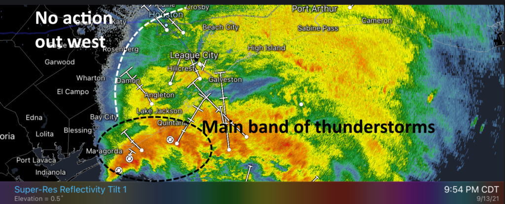
Annotated radar snapshot shortly before 10 pm CT Monday. (RadarScope)

As this system slogs toward the northeast over night, it will have the potential to drop rainfall across all Texas coastal areas. However, for now, it appears the heaviest rains will come over Galveston and Chambers counties, with lesser amounts further east, including the Beaumont and Port Arthur areas on Tuesday morning.

Wind and power outages

For inland counties, including Fort Bend and a majority of Harris County, this now appears more likely to be a wind storm rather than one of significant rains. As of 9:30pm about three quarters of Matagorda County were experiencing power outages as Nicholas battered its shores with hurricane-force wind gusts. These winds, although diminished, should spread inland over the next several hours. I’d expect at least scattered outages as trees fall into power lines.
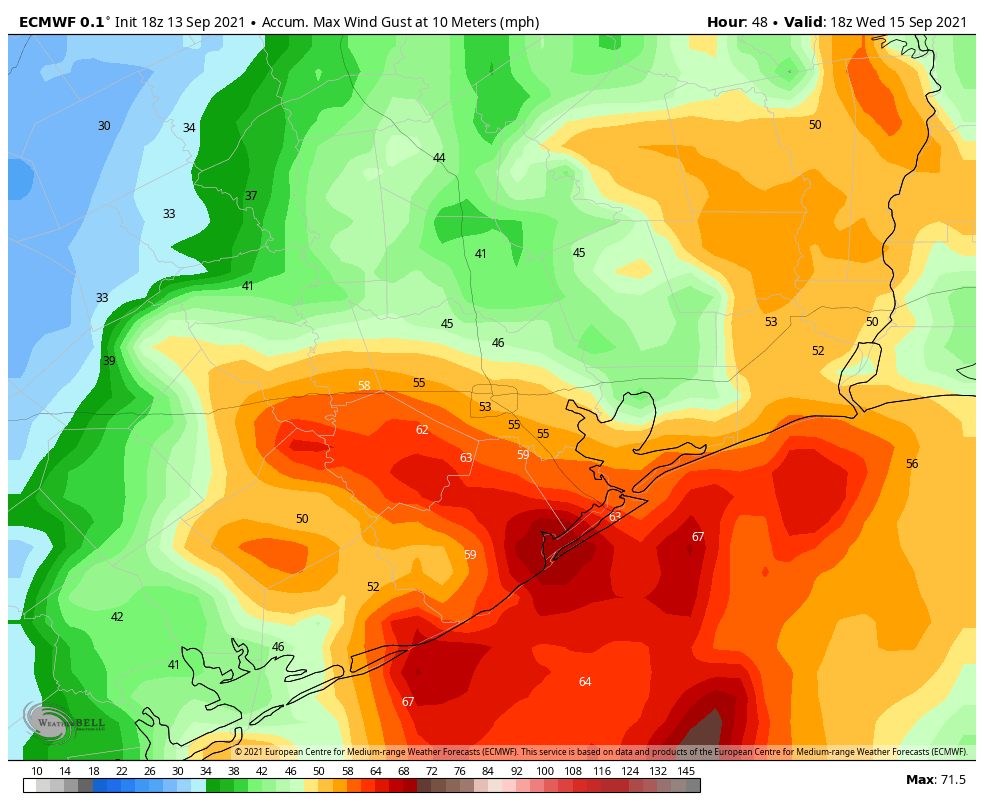
One model forecast for maximum wind gusts from Tropical Storm Nicholas. (Weather Bell)

When does this mess end?

Our confidence in when the heaviest rains from Nicholas push east of Houston remains middling, but I’d expect rains in Galveston County to wind down around sunrise or mid-morning.

Our next update will come at around 1 am CT.
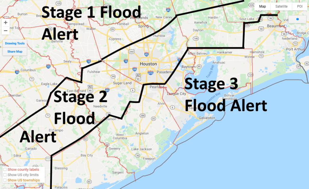
As Nicholas nears, we are lowering our Flood Scale alert for all but the coast

Good evening. Tropical Storm Nicholas is nearing the middle Texas coast and should make landfall near Matagorda Bay within several hours. The storm’s maximum winds increased to 65 mph this afternoon, and it’s quite possible Nicholas will become a Category 1 landfall before landfall tonight. Wind gusts from Nicholas are starting to arrive along the upper Texas coast, and should peak around midnight or during the wee hours of Tuesday.

As Nicholas nears the shore we are starting to get more confidence in rainfall forecasts for tonight and Tuesday morning as the heaviest rains from the storm move through. And as a result of this we are lowering our Flood Stage alert for all but coastal counties.

Space City Weather Scale Alerts as of 5 pm CT on Monday. (Google maps)

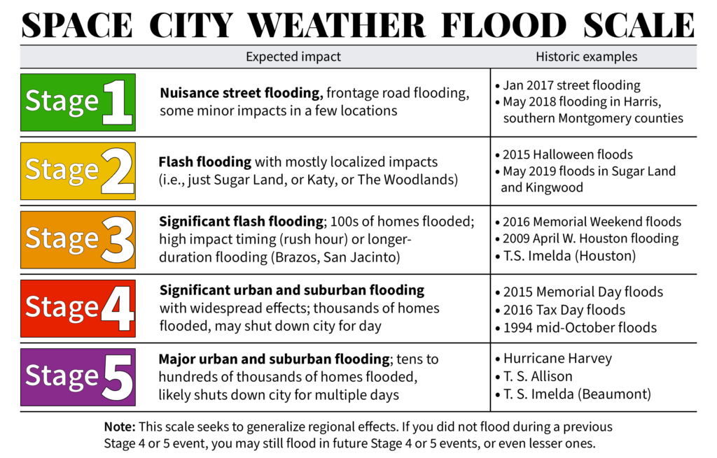
As you can see on the (very professionally drawn) map above, we are keeping a Stage 3 alert for coastal counties, Stage 2 for the next tier, and Stage 1 for areas northwest of Houston. Basically, if you live near the coast, an additional 6 to 12 inches of rain is possible tonight, with higher localized totals. For areas roughly along Interstate 10, values should be about half of this, give or take. And for areas well inland, overall accumulations will likely be 3 inches or less. As a reminder here’s what our various flood scale alerts mean:

Timing of events

The overall pattern for events tonight should not change a whole lot. Heavy rainfall will advance from the southwest into the Houston region tonight, likely reaching a corridor from I-45 South to downtown Houston around midnight, or an hour or two later. These storms will then continue to push to the northeast, perhaps moving away from Harris County by around sunrise or mid-morning.

Maximum wind gusts of 50 to 60 mph will likely move into Brazoria and Fort Bend counties by late evening, with gusts in the 40s reaching Harris County by around midnight. These winds should begin to weaken by around sunrise on Tuesday morning. Expect scattered power outages, at least, as trees and debris fall into power lines.

We think conditions may begin to improve across the area by around sunrise on Tuesday, or perhaps mid-morning. So our advice is to not have any concrete plans for Tuesday morning, as we cannot say a whole lot about conditions with confidence. By Tuesday afternoon we expect conditions to improve markedly. At this point we think Wednesday should see a return to normal activities across the region without too much difficulty, and excluding any areas that saw widespread flooding on Monday night.

Our next post will come by around 10 pm to fine-tune the forecast for tonight and Tuesday.

Still concerned about flooding from Nicholas, but things trending a bit better

Good afternoon. Much of Houston is seeing a reprieve from storms after a band of showers moved through the region around noon. It looks as if rain showers will remain somewhat scattered and non-threatening through the late afternoon or early evening hours. The main event is still offshore, and will reach our region later tonight.

Speaking of the main threat, Tropical Storm Nicholas retains 60 mph winds as of 1 pm CT, and continues to move north toward the Texas coast. It likely will make landfall near Matagorda Bay later this evening. The storm covers nearly all of the western Gulf of Mexico this afternoon.

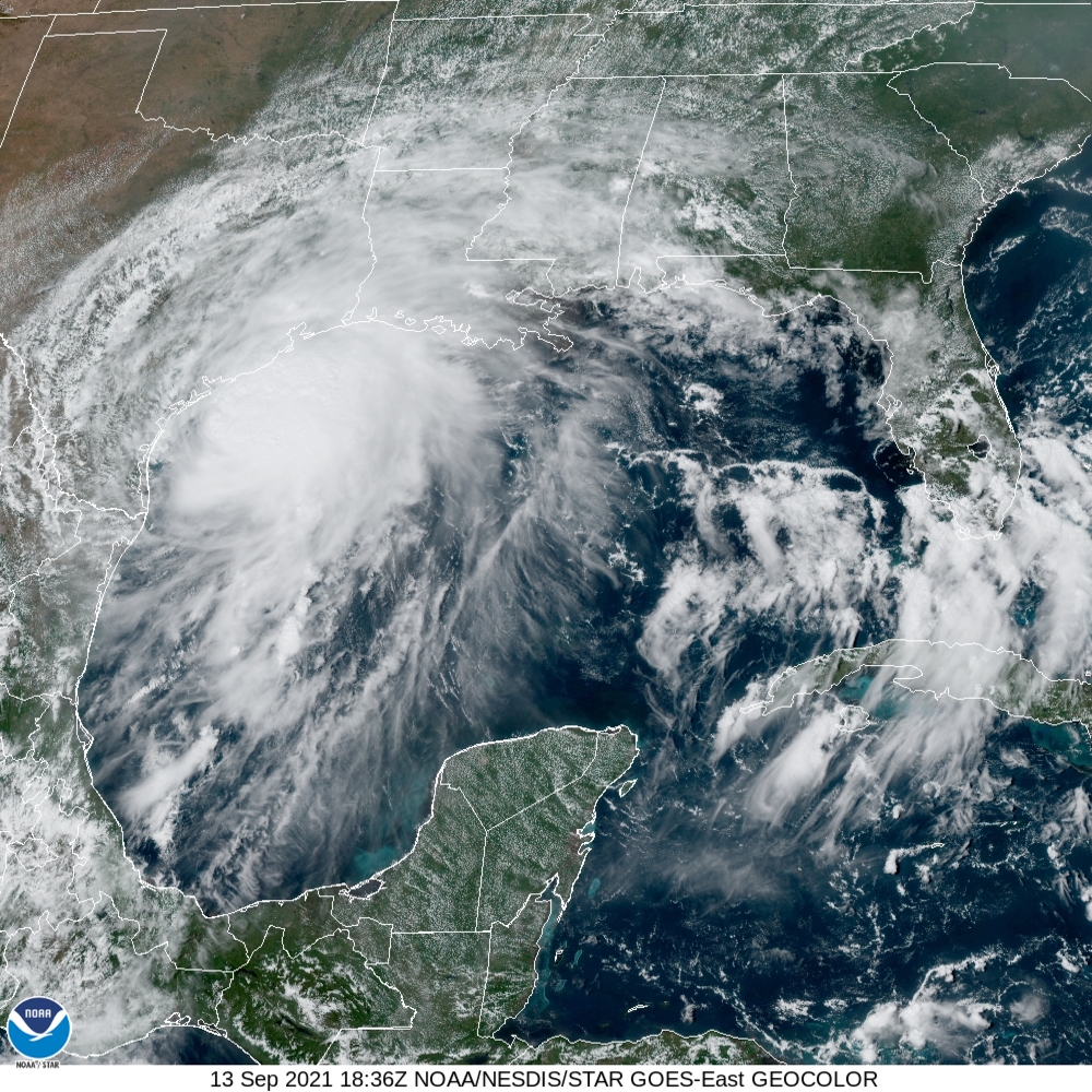
Satellite image of Tropical Storm Nicholas at 1:36pm CT Monday. (NOAA)

Throughout the day, we’ve been getting our first inputs from high-resolution models about rain accumulations tonight and on Tuesday for the Houston metro area. The early returns suggest that most of Houston may fare pretty OK from rain dropped by Nicholas. We still have some very serious concerns, however. Let’s discuss.

Our confidence is increasing that a line of storms associated with the core of Nicholas will move into our region from the southwest tonight. It looks like these storms will reach Brazoria County around midnight, or shortly thereafter. Then they should progress toward downtown and the I-45 South corridor some time after midnight and before 6am CT on Tuesday. This is a little slower than previously anticipated, and may give Houston residents a few hours after sunset this evening before roadway conditions deteriorate. (Gusty winds will probably also arrive in Harris County around midnight, or after).

The other major shift we’ve seen in some of the model guidance is that the threat for heavy rainfall is becoming more concentrated along the coast, in places like Brazoria, Galveston, and Chambers counties as well as the Clear Lake area of Harris County. If this forecast holds, areas inland of Interstate 10 may see only a couple of inches tonight, whereas the coast will face a higher threat of 5 to 15 inches. One of our big questions right now is whether the heaviest precipitation falls offshore, or along the coast in places like Matagorda, Sargent, Freeport, and Galveston Island.

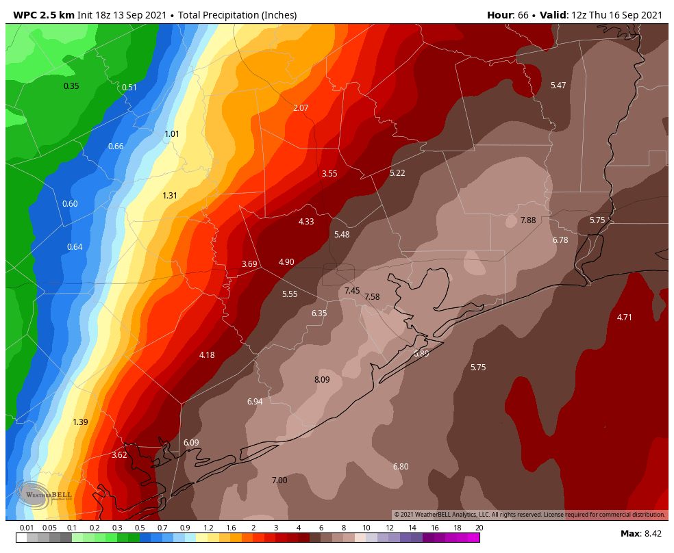
NOAA rain accumulation forecast for now through Wednesday. (Weather Bell)

Matt and I have discussed this quite a bit this afternoon, and for now we’re holding to a Stage 3 flood scale warning for the entire Houston metro area. But that probably oversells the threat to locations north of Interstate 10. We’re going to continue to look at more data and decide whether to reduce our flood scale warning later today. We’ll leave you with this: It’s OK to have some hope about the Nicholas forecast, but we still have a lot of questions and a very explosive, tropical air mass headed this way.

Our next update will come at 6 p.m.

What to expect, and when to expect it, from Tropical Storm Nicholas

This post will attempt to set expectations for the timing of Nicholas’ rains and winds later today, tonight, and on Tuesday for the greater Houston metro area. Given that there remain some questions about the storm’s precise track and movement speed, these remain estimates, rather than set-in-stone predictions. But we recognize that this information is important for planning purposes, and so we’re giving it our best shot. Thank you for understanding that this is an, uhhh, fluid situation.

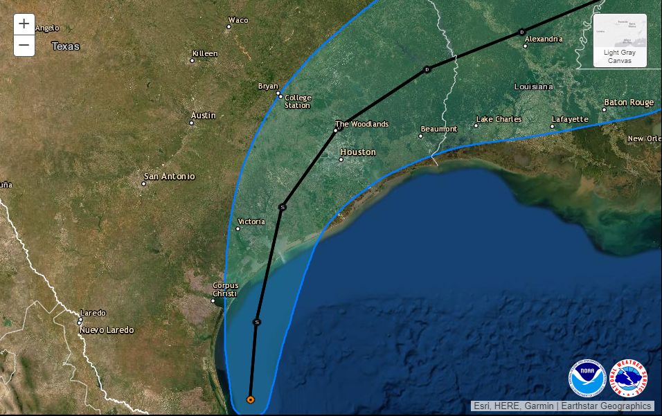
The center of Nicholas has been wobbling somewhat this morning, but the National Hurricane Center says the storm is still moving generally northward, and should approach the Texas coast this evening near Matagorda Bay. The storm retains 60 mph winds, and is being hampered by a bit of dry air and wind shear. However, this shear may relax enough to allow Nicholas to strengthen into a Category 1 hurricane before landfall. It will be close. The storm then should move almost directly overhead the Houston area on Tuesday. This post discusses what to expect from this track.

Monday, 10 am CT, official forecast track for Tropical Storm Nicholas. (National Hurricane Center)

Monday day time

So far, as expected, showers and thunderstorms have been manageable today due to their fairly rapid motion. We should continue to see fast-moving showers traveling from the southeast to northwest throughout the daytime hours. Some of these could be briefly severe, but we don’t anticipate any significant flooding. Winds may also pick up this afternoon, but are unlikely to gust above 30 mph from the east-southeast.

Monday night and Tuesday morning

Based upon our latest data, the period of greatest impact now seems likely to occur between sunset on Monday and about noon on Tuesday. If you want to be perfectly safe, the best plan is to remain off the roads in the Houston area from around 6 pm CT Monday through the middle of Tuesday. However, we realize that this may not be possible for everyone.

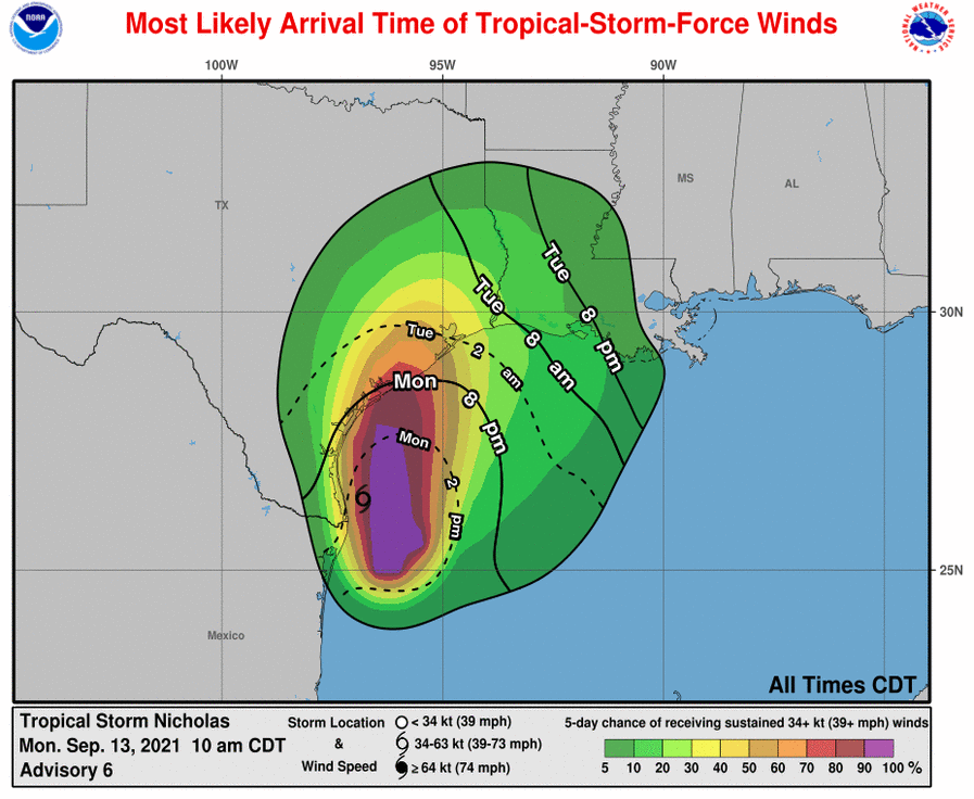
In terms of winds, we expect things to start getting breezy by around 10 pm to midnight, particularly along Galveston Island, where gusts may briefly reach hurricane strength. In Harris County, sustained winds may reach 30 to 40 mph, with gusts in the 50s to 60s, especially by midnight or shortly after. This may well lead to some power outages, especially south and west of Houston. I inquired to CenterPoint about their expectations for power losses tonight, but have not heard back. Past experience with such winds suggests there will be isolated to scattered outages due to debris and tree branches that get blown into lines. A storm surge of 2 to 4 feet is likely along the upper Texas coast.

Most likely arrival time, and probability of tropical storm-force winds. (National Hurricane Center)

With regard to rainfall, the heaviest storms associated with the core of Nicholas are likely to approach the southern part of the region, including areas such as Lake Jackson, by around 9 pm. The storms should then move near the central part of the metro area, including the I-10 and I-45 south corridors, around midnight or shortly thereafter. As the core of Nicholas moves near the area, the rains should be just ahead of it, possibly exiting Houston by Tuesday morning, or around Noon.

How much rain is going to fall?

This, as ever, is the difficult question. Our highest resolution models continue to indicate the possibility of very intense rainfall rates of 3 to 5 inches per hour, which will quickly back up streets and bayous. It is not advisable to be out and about when these kinds of storms hit—especially because it will be dark, and driving in these conditions is dangerous.

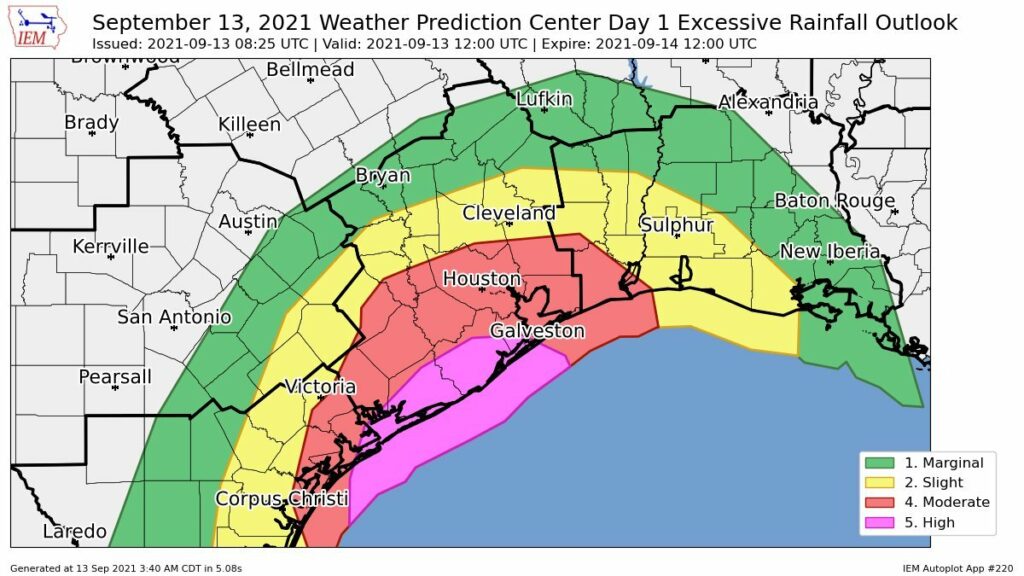
The good news is that it still appears as though Nicholas will keep moving as it tracks through Houston on Tuesday, and away from the region on Tuesday night. This should help to limit overall rainfall totals for most to 5 to 15 inches of rainfall, with a few isolated areas seeing 15 inches or more. Rains totals will be greatest for coastal counties and the next inland tier, which includes Harris and Fort Bend counties.

Graphic showing a “high” threat of excessive rainfall south of Houston through Tuesday morning. (NOAA)

What about air travel? Schools? The Harry Styles concert?

We’d love to be able to give you concrete answers on these questions, but we don’t have them. I think airline flights from after about 6 pm today through Noon on Tuesday are a big question mark, and I’d probably at least expect some delays.

Area schools should be closed on Tuesday, period.

As for Harry Styles, man, I don’t know. My daughter has been waiting months for this concert and right now there’s a chance the really heavy rains will hold off until after the show is over. But there’s also a reasonable chance its cats and dogs as the show is letting out of the Toyota Center. If they don’t cancel the concert, I’ll hope to be able to provide some better guidance later this afternoon. The safe thing is not to go, of course.

Our next post will come by 2 pm CT.

Get our latest updates, immediately

As a reminder, to receive instant notifications of our new posts, you can download our free app on Android and Apple devices.