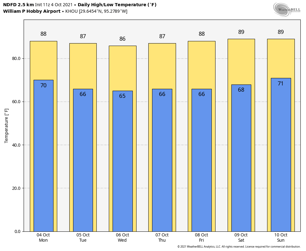
The forecast for the week ahead is pretty straightforward and locked in, so we’re not going to take up too much of your time this morning. Expect lots of sunny skies and somewhat drier air through about Saturday, after which the onshore flow returns. Some slight rain chances return late Sunday or Monday.
Tuesday
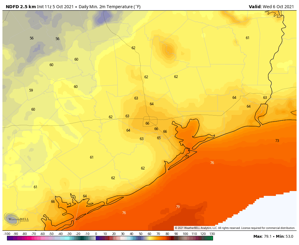
Some readers have groused that this isn’t much of a front, and I’m here to tell you there’s a reason why we characterized it as a weak one. The truth is, we’re mostly just seeing a northerly flow rather an abundance of colder air. Nevertheless this flow will have a salutary effect on our humidity levels for awhile. Today should be the driest day, with dewpoints dropping into the 50s, and accordingly I think Tuesday night and Wednesday morning will see the lowest temperatures for the week. Highs today should be in the mid- to upper-80s, with lows tonight dropping to about 60 degrees for inland areas, and low 70s right along the coast.
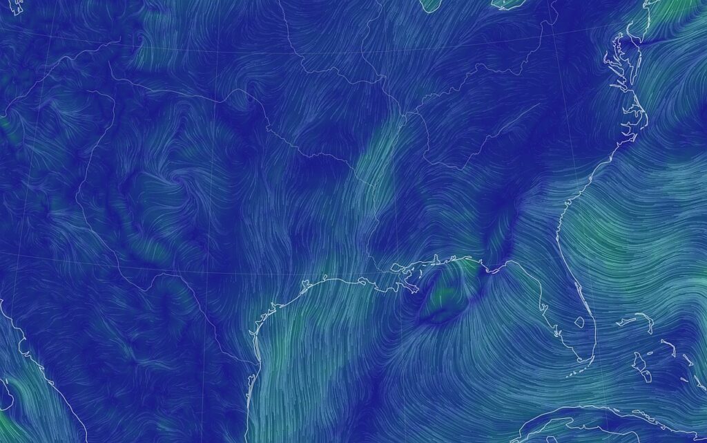
An upper level low pressure system over the central United States is driving a northerly flow into East Texas. (earth.nullschool.net)
Wednesday, Thursday, and Friday
Rinse and repeat. These will be sunny days, with highs in the upper 80s and lows in the 60s for most. The air will not be super dry, but it won’t be sultry and humid either. Take what you can get in early October, I say.
Saturday and Sunday
Saturday should more or less see a continuation of the weather we see most of this week, albeit with slightly rising humidity levels. Sunday should feel more like “Houston,” as the onshore flow resumes, and dewpoints start to climb toward 70 degrees. Highs this weekend will be in the upper 80s to 90 degrees, with mostly sunny skies. A slight chance of showers returns Sunday night.
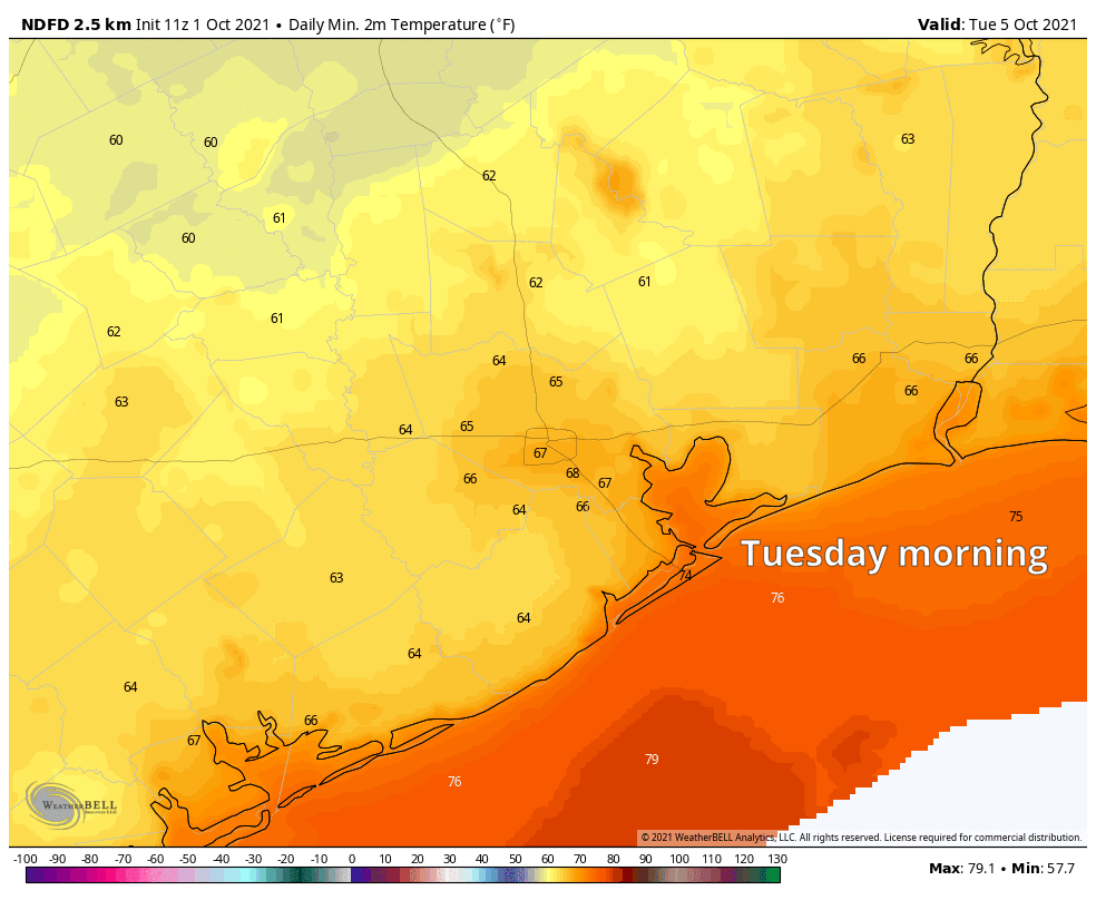
Wednesday morning’s temperatures, shown above, will be the coolest of the week. (Weather Bell)
Next week and beyond
Most of next week looks warm, with highs near 90 degrees, but right now there’s no real signal in the models for too much in the way of rainfall. When is the next real cold front coming to Houston, you might ask? Right now there’s a pretty decent signal in both the European and GFS ensembles for something about 12 days from now, circa October 17. But that’s a long, long, long way out for us to have any confidence in the model forecasts. So we’ll just have to wait and see.
The threat of heavy rainfall has passed, and Houston will now enter a period of tranquil weather. Drier air will move into the region today in the wake of Sunday’s front, and we should see moderately cooler nighttime temperatures through Friday or Saturday morning. After this morning, rain chances are basically zero until at least next Monday or Tuesday. Enjoy the sunshine.
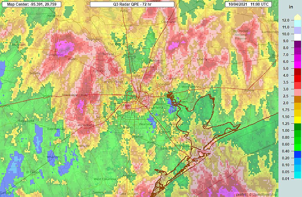
Radar estimated rainfall for Friday through Sunday. (NOAA)
Monday
Some clouds remain this morning across the region, but these should mix out as the day progresses to leave us with mostly sunny skies. Winds will be light, out of the north at 5 to 10 mph. With ample sunshine, highs will reach the upper 80s for most of Houston. But as dewpoints fall through the day, we’ll see pleasant conditions this evening, with lows dropping into the mid-60s in Houston, with warmer conditions along the coast, and cooler for inland areas.
Tuesday through Friday
Conditions more or less remain the same for the rest of the work week, with sunny days and highs in the upper 80s. Lows will be in the 60s. Dewpoints will bottom out on Tuesday, so this will feel like our driest day, but humidity levels will remain reasonable for the whole week.
Houston will now enjoy a stretch of moderately drier and cooler weather. (Weather Bell)
Saturday and Sunday
More of an onshore flow returns this weekend, and temperatures will return to more summer-like levels, with highs near 90 degrees and overnight lows in the 70s. The humidity won’t be oppressive, but it will be noticeably higher. After this point we’ll be on the lookout for the next cold front, but most likely an approaching front will stall before entering Houston early the following week.
Good morning. Depending on where you live this morning, it’s either quite stormy, raining gently, flash flooding, or doing not much at all. Most areas should see at least some rain this morning before all is said and done. Additional rain chances will continue through Sunday before a cool front ends this active pattern for us.
Today
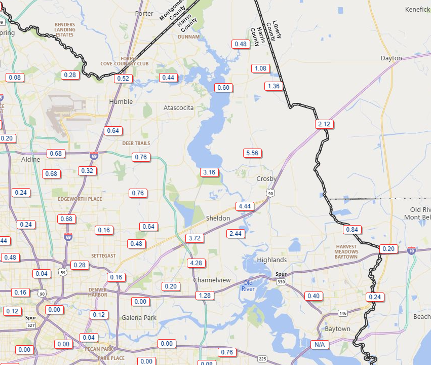
The eastern portion of Harris County has seen the bulk of the heaviest rain this morning, with areas north of Channelview through Crosby seeing 3 to 6 inches of rain so far, prompting a Flash Flood Warning through 9 AM for that area.
Rain totals in eastern Harris County have been significant and have likely caused flash flooding near Crosby, Sheldon, and generally north of Channelview. (Harris County Flood Control)
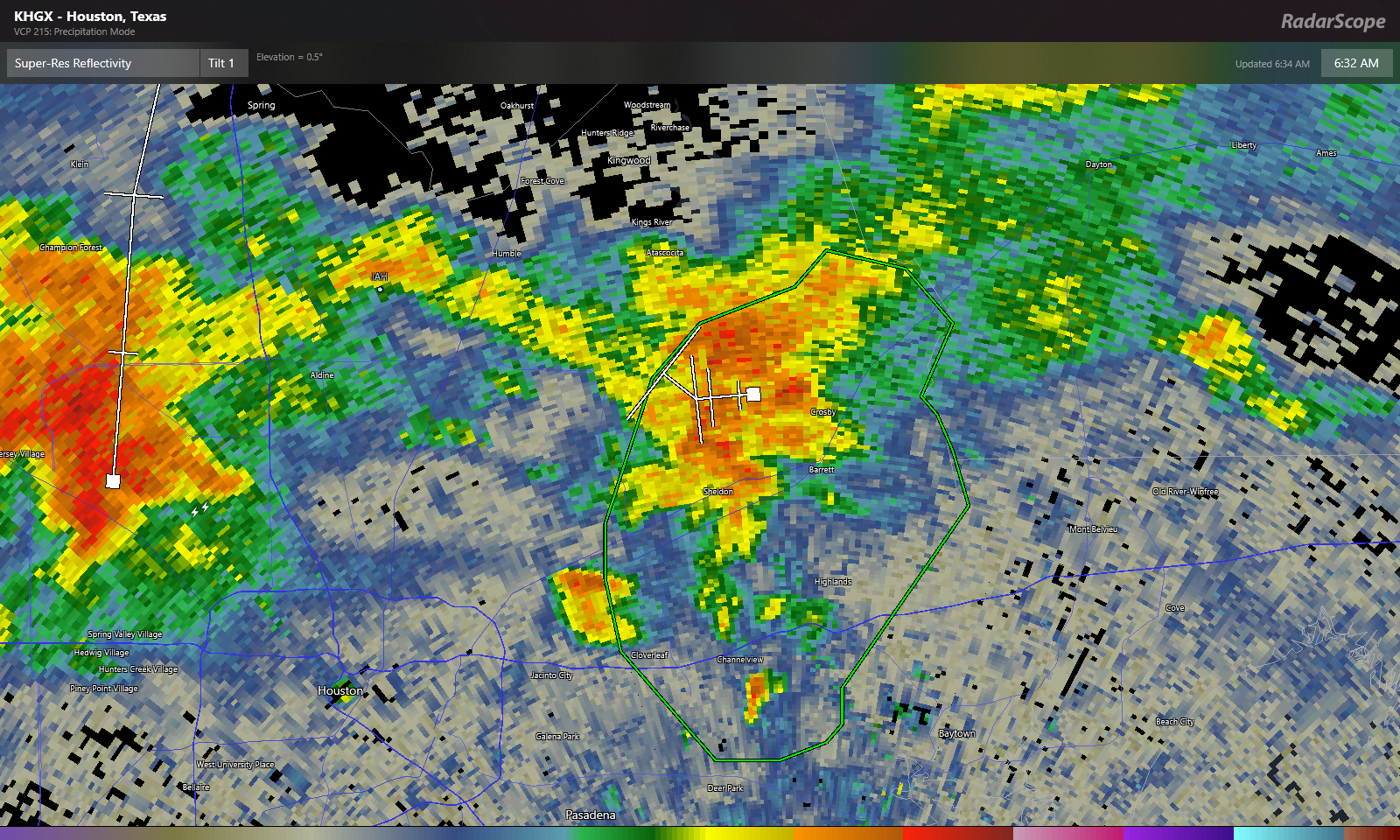
Over 2 inches of that 5.5″ near Crosby has fallen between 5:30 and 6:30 AM. At one point they had about 3 inches in an hour there. That will do it. Heavy rain continues in that Flash Flood warned area, but hopefully the pace slows over the next hour or so.
Heavy rain continues near Crosby but should hopefully be slowly exiting. Additional rain is possible in the flash flood warning area (green box) this morning, however. Click to enlarge. (RadarScope)
Zooming out, heavy rain is also lifting out of Spring Branch and impacting the northwest Beltway as of 6:35 this morning. Additional heavy rain was falling in the Katy and Fulshear areas and to the north in Hempstead and across Waller County. All of this is generally lifting north while redeveloping and easing to the east.
Rain continues to gradually advance east, so expect a soggy morning in much of the area, and where it hasn’t yet rained it very well may in the next few hours. (College of DuPage)
Expect periods of rain, heavy at times through the morning. Localized flash flooding like we see in eastern Harris County this morning can’t be entirely ruled out, so just use caution if you will be out and about through the morning. Rain probably should taper to scattered showers this afternoon. Temps will be held down due to the clouds and rain today, probably no better than the low-80s.
Saturday
Another round of showers and storms scattered over a fairly wide area seems likely tomorrow. If you are trying to make plans for outdoor events, it’s a bit tricky. The guidance I want to give you versus the guidance I can reasonably give you with the model data available are two very different things! Right now, it won’t be a washout it seems. So that’s good. As far as timing, my best guess is that we’ll see showers and storms developing closer to the coast in the morning, then spreading inland through the late morning and early afternoon, somewhat like what we experienced on Thursday. Not everyone sees rain, but those that do could see some fairly heavy rain for a short time. That said, this is very much subject to change, so no matter where or when your plans are tomorrow, at least have a backup option in mind if you get chased indoors by rain for an hour or two. Highs will be in the 80s after morning lows in the 70s.
Sunday into Monday
Alright, the end of this active pattern looks to begin on Sunday. There should still be showers and storms around on Sunday, driven in part by the front which will be dropping southeast through the day. Ahead of the front will see the best chance of rain, and this should include the Houston area through the coast. I don’t think the coverage on Sunday will be quite as significant as we see today and will see tomorrow, but as on those days, any rain could be locally heavy. Look for 80s, possibly mid to upper-80s on Sunday.
As far as the front goes, look for it to slog through the area. It should arrive in Houston on Sunday evening, then only slowly advance to the coast, hopefully clearing it by Monday morning. And I’m intentionally calling this a “cool” front because behind it, while we will have noticeably lower humidity, the temperatures won’t be much more than slightly cooler.
Tuesday and beyond
In fact, Tuesday morning should see pleasant lows in the 60s. Daytime highs, however, will be in the mid-80s at least. The humidity will be much lower though.
Tuesday should see very comfortable morning lows in the 60s everywhere away from the immediate coast, while daytime highs will remain rather hot with at least mid-80s expected. Humidity will be noticeably lower though. (Weather Bell)
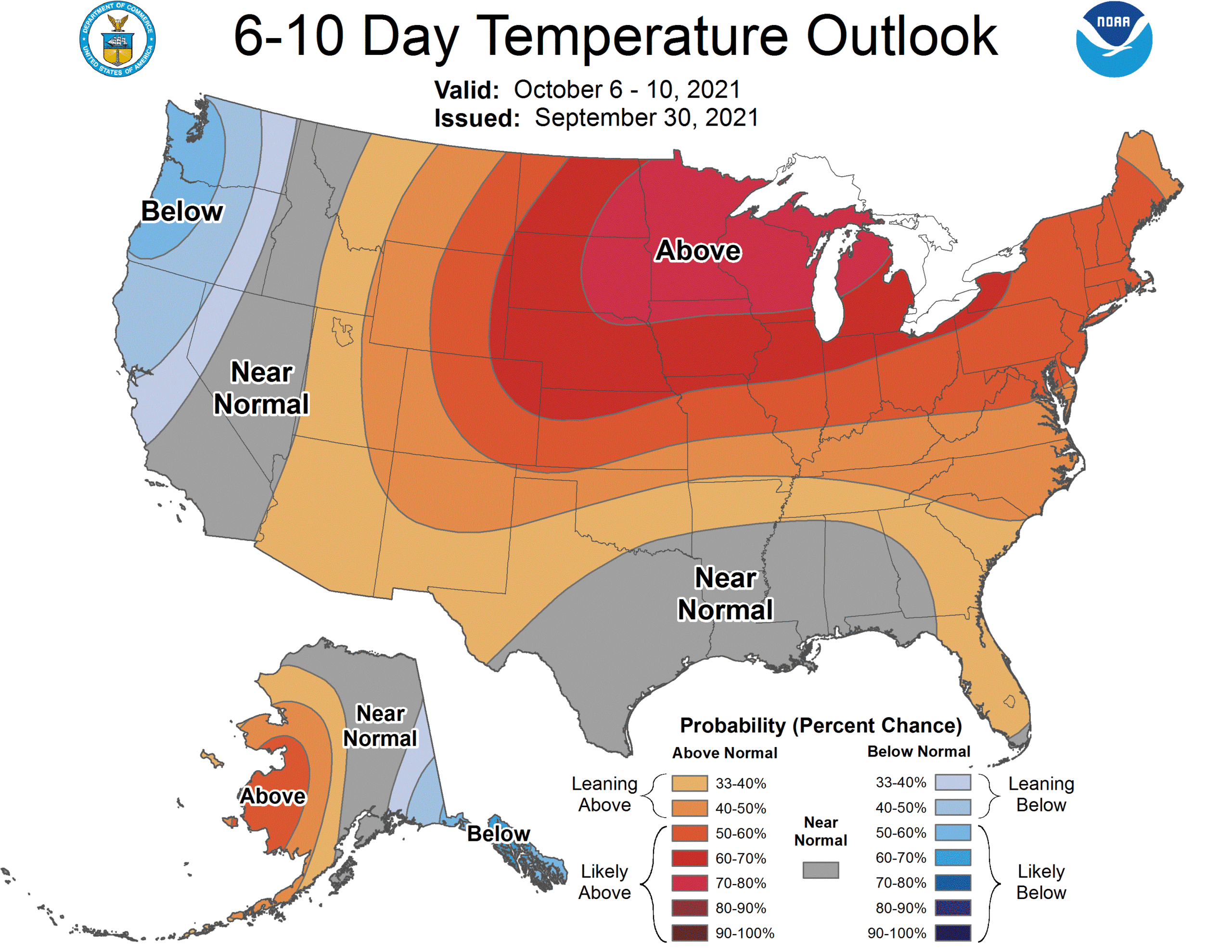
This relatively nicer weather should continue most of the week, with sun-filled skies, warm days, and pleasant evenings. The overall pattern across the U.S. is one that favors very warm weather in the northern part of the country, while we see temperatures maybe only a couple degrees above average.
A warmer north/normal south type setup should dominate the U.S. weather map next week. This should keep any *strong* cold fronts at bay for a bit. (NOAA)
This pattern is important for us here in Houston because it should limit the chances of any very strong cold fronts into Texas. In fact, when I look at most model data after next week, I see minimal chance for any sort of meaningful fronts through mid-month. That could change, obviously but sitting here today, I’m not optimistic we are going to see any legitimately cool weather here anytime soon.
Tropics
Hurricane Sam continues to rage in the open Atlantic, back up to a strong category 4 storm this morning, with winds of 150 mph. Sam has been really incredible to watch meteorologically, and thankfully avoiding all land masses, the best kind of hurricane.
Hurricane Sam is raging over the open ocean with 150 mph maximum sustained winds. (Tropical Tidbits)