Here is our early look at the forecast for Christmas week

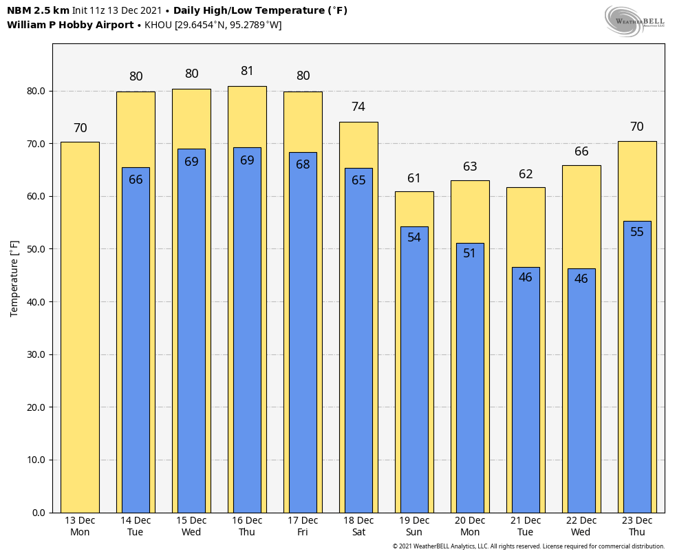
Good morning. After a winter-like weekend, our temperatures will be back on the upswing toward near-record heat this week, with highs of around 80 degrees from Tuesday through Friday. By week’s end another front will arrive, and this should usher in more typically chilly weather for December. What happens after that? Read on below for full details about the Christmas week forecast.

Lows this morning are 10 to 20 degrees warmer than Sunday morning, and we’re only going up from here. (Weather Bell)

Monday

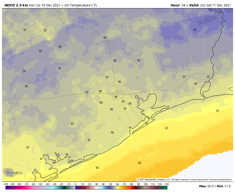
Temperatures are generally in the 50s across the metro area this morning, and we can say goodbye to those after a few hours. Today will generally be mostly cloudy, which will help to limit high temperatures to about 70 degrees. Some very light rainfall, almost mist-like, will be possible later today, but any accumulations should be scant. Winds will be light, shifting to come from the southeast later today. Lows tonight will only drop a few degrees from daytime highs, into the mid-60s for most.

Tuesday

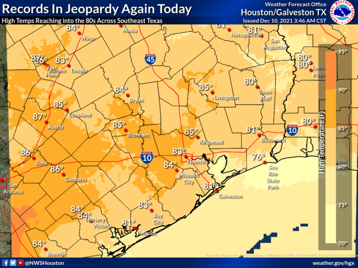
Dewpoints on Tuesday will morning will be about 20 degrees higher than on Monday, and accordingly it’s going to feel pretty muggy outside. Some fog will be possible as a result. As skies clear out some on Tuesday, high temperatures will reach about 80 degrees. Overnight lows will drop to around 70 along the coast, with conditions a few degrees cooler inland. This is about 20 to 25 degrees above normal for this time of year.

Wednesday

Conditions will be more or less same as on Tuesday, although winds out of the south will be more noticeable, gusting above 20 mph.

Thursday and Friday

The pattern remains more or less the same. On Thursday a front will move into northern Texas and stall. This may provide the impetus for some cloud cover and potentially some showers locally, but in truth I don’t think there will be too much sensible effect on the Houston area weather. There is a stronger front coming, but it probably won’t reach the Houston metro area until Saturday morning.

We can expect rain accumulations of about 1 inch through Sunday. (Weather Bell)

Saturday and Sunday

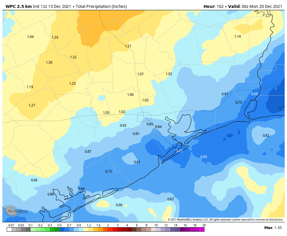
The weekend is mostly going to be wet, gray, and cold. There are still some uncertainties in terms of timing, but at some point between Friday night and noon on Saturday a strong front will blow in. The details are yet to come, but as there will be plenty of atmospheric moisture with which to work, and this front will be bringing a significantly colder air mass into a warm one, rain showers and thunderstorms are definitely possible. Temperatures after the front on Saturday should be in the 60s, with lows likely in the 40s.

The rain probably isn’t going anywhere on Sunday, with a solid 50 percent chance of rain, and highs again probably topping out at about 60 degrees. Lows will again likely be in the upper 40s on Sunday night.

Most of this week will be decidedly un-winter-like. But the pattern changes this weekend. (Weather Bell)

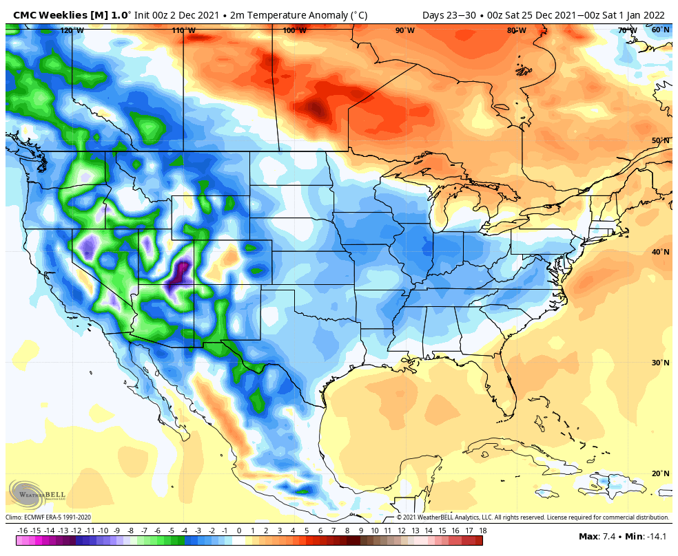
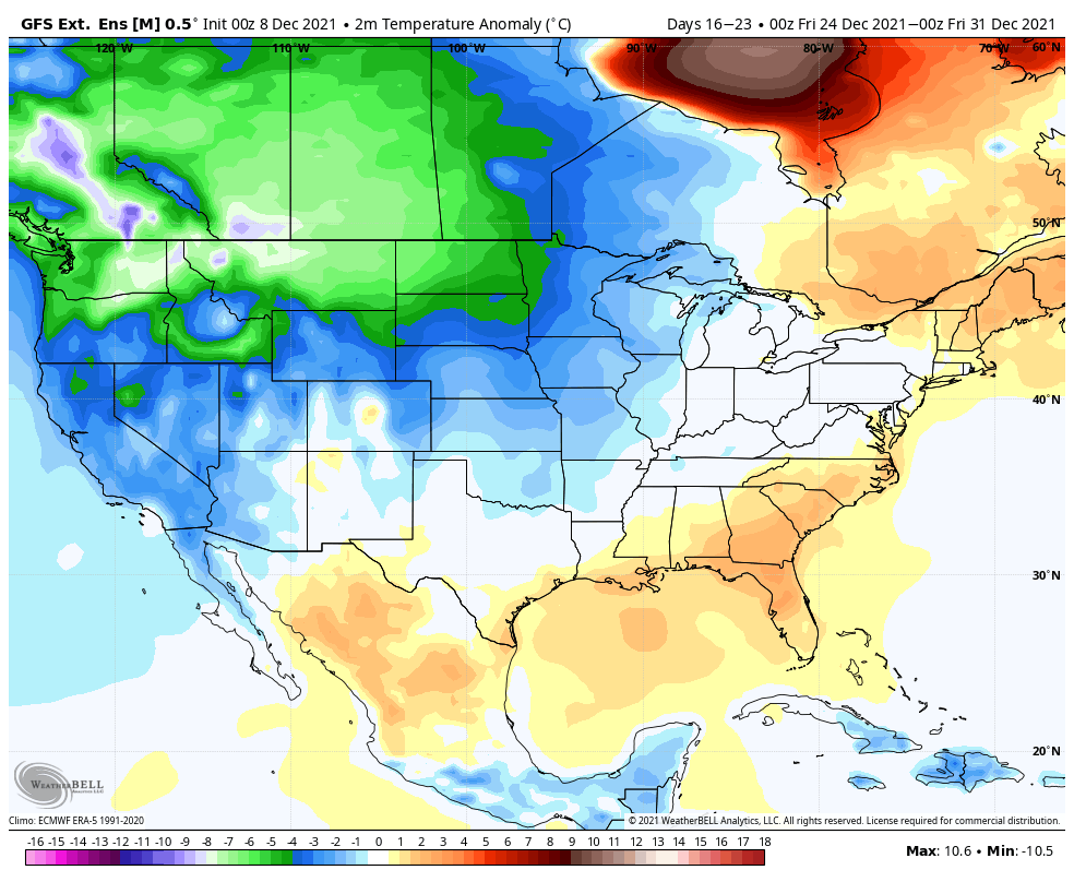
Christmas week outlook

Eventually our atmosphere should settle down, and right now I think this probably will happen on Monday, leading to gradually clearing skies and lowering rain chances. This should set the stage for clear and cool weather through at least Wednesday, with lows solidly in the 40s.

There is no clear guidance in the models about what comes after this, but the most likely scenario is warming trend through next Friday, Christmas Eve, or Saturday, Christmas Day. In this case, I’d guess we’re looking at highs in the 70s with warmish nights for the holiday. Right now there is no strong signal for heavy precipitation around Christmas, nor particularly cold temperatures, so snow is not on the menu. If this sounds un-festive to you, take some hope that there’s a non-trivial chance that another front slides through before Christmas, in which case things would feel more seasonal out. We shall see.

Thursday was Houston’s warmest December day on record; we will make a run for it again today

On December 3, 1933 Hobby Airport reached 85°, making it the warmest December day on record, a record that held for 88 years and finally fell yesterday when Hobby topped off at 87°. The City of Houston officially hit 84° on that December 1933 day, a record that stood until December 3, 1995, when Bush Airport hit 85°. Yesterday, for the first time since that 1995 day, Bush Airport hit 85° in December. Yesterday was most likely the warmest December afternoon on record in the Houston area. It’s not impossible to think today could be equally hot.

Today

After watching my Rutgers Scarlet Knights men’s basketball team upend #1 Purdue last night, it was tough to come down from that high. Then I opened the door this morning. We all have opinions about warm weather in winter ranging from “This is amazing” to “I hate everything.” I don’t personally care for it, but alas, here we are. Today will be another scorcher by December standards. We will have a mix of clouds & sun with highs likely in the mid-80s.

Back to the 80s again today! (NOAA)

Coastal fog has been mitigated some by a breeze overnight. We could see fog attempt to develop in Galveston and coastal locations at any point today though, particularly if winds lighten up some late. A stray shower or some drizzle is also possible today.

Tonight & Saturday

For those sick of the hotter weather, you may bask in the weekend. We will continue quite warm and humid tonight. Temperatures will not go very far, with steady readings in the 70s likely into the early morning hours. The cold front will arrive with authority after 4 A.M. on Saturday in central Houston, an hour or two sooner northwest of the city and an hour or two later southeast. By sunrise, the front will be offshore. Look for temperatures to plunge from the mid-70s into the 50s, where they likely will stay for most of Saturday.

Temperatures around 4 PM on Saturday will be far from the 80s! Look for 50s and a gusty breeze in most of the area. (Weather Bell)

In addition to a change of seasons, this front will come with some showers and storms. Look for a narrow but potentially noisy line of brief storms after 2 or 3 AM on Saturday, ending around sunrise. This will be followed by clouds, along with some light rain or a few showers perhaps. Wind gusts of 20 to 25 mph will accompany all this, just to add to the autumnal ambiance. I don’t expect us to see much sunshine on Saturday until perhaps late in the day.

Sunday

As skies clear out late Saturday evening and winds back down some, temperatures will fall as well. Look for Sunday morning to begin in the low to mid-40s in most places, with some 30s likely outside the city. Sunday itself looks gorgeous. Expect sunshine and highs a bit above 60 degrees.

Next week

The return to autumn or early winter weather will be brief. We warm up a little beginning Monday, with morning lows in the upper-40s and daytime highs in the low-70s under sunshine. Monday actually looks spectacular, although clouds may increase through the afternoon.

By Tuesday, onshore flow will begin to exert more influence. This will warm us and bump back up the humidity. Look for highs well into the 70s and lows in the 60s. More of this on Wednesday and Thursday is expected. Yes, we could hit 80 degrees again one or multiple times into late next week. In addition to all this, the usual suspects that typically accompany these December warm ups (clouds, scattered showers, and fog) will join us again as well.

When will we see another cold front? As of this morning, the Euro has one around Sunday next weekend, while the GFS is more like the Monday or Tuesday the week of Christmas. Keep the shorts handy a little longer.

Will December ever start to feel like winter for an extended period of time?

This month has started out with significantly warmer than normal weather. So far we have experienced four 80-degree days, and the average temperature has run about 10 degrees above normal. Cooler weather has been the exception in December, rather than the norm. And this pattern seems likely to continue through at least the first two-thirds of the month. So is there any chance of a colder turn toward Christmas, the remainder of the holidays, and New Years?

NOAA’s outlook for temperatures through Dec. 22 show something of a blow-torch effect for much of the United States, including the Houston region. (Pivotal Weather)

The pattern for the middle third of the month is pretty set. We’re going to warm back into the 80s to end this work week, a strong-ish front will cool things down for the weekend, and then we’ll be back into at least the upper 70s for most of next week. So eight or even nine of the next 10 days will see warmer than normal weather. So what of the last 10 days of the month?

This extended period lies beyond the ability of our existing models for precision forecasting. However, it does look as though some sort of front may arrive around Dec. 20. After that the “weekly” models from all of our sources suggest somewhat more normal weather to end the month. That is, instead of days in the 70s and 80s, and nights in the 50s and 60s, we can more probably expect days in the 60s and nights in the 40s or 50s. At this point—and it really is way too early to say this with any confidence, but here goes anyways—I’m seeing little signal for a freeze before the end of the year. But we shall see.

The bottom line: The first two-thirds of December are going to be quite a bit warmer than normal, but the last part of the month should feel more seasonal. Probably. We think. I mean, it has to feel like Christmas sometime, right?

Thursday

There is some patchy fog west of Houston this morning, but this should burn off within a few hours. After it does, skies will remain partly to mostly cloudy, as temperatures rise into the low 80s. Some very light showers or drizzle will be possible throughout the day, but chances are less than 20 percent. Temperatures across much of the region are unlikely to fall below 70 degrees, a very sticky night for December.

Friday

This will be another warm and mostly cloudy day, with high temperatures in the low to possibly mid-80s. This will also be another day during which light showers are possible throughout the day, but accumulations should not be anything to write home about. Expect another warm night ahead of the frontal passage.

Saturday

At some point a ragged line of showers and thunderstorms will progress through the region ahead of the front. This line probably arrives in areas northwest of Houston an hour or two after midnight, reaches the city a few hours later, and arrives at the coast just before sunrise. Accumulations should measure a few tenths of an inch of rain for most. A significantly drier air mass will move in an hour or two behind the rain, and with dewpoints falling into the 30s, the air will indeed feel much drier. Highs should drop into the 50s during the afternoon hours with wind gusts reaching 30 mph. Winds start to die down a bit during the evening, with lows dropping into the 40s for most of Houston.

Low temperature forecast for Sunday morning. (Weather Bell)

Sunday

A truly winter-like day with mostly sunny skies, highs in the low- to mid-60s, and another chilly night in the 40s and 50s.

Next week

As mentioned above, we’ll see a warming trend next week, with high temperatures recovering into at least the mid- to upper 70s by Tuesday, and onward.

It’s beginning to feel not like Christmas, everywhere you go

Low temperatures are generally around 60 degrees this morning, and we’re going to be on a continuous warming trend until Friday night, when a fairly strong cold front arrives. The record high temperature for Thursday (84 degrees, 2019) and Friday (83 degrees, 1939) are both definitely in play. The weekend will see much more seasonal weather, with highs dropping back into the 60s, and lows mostly in the 40s.

Wednesday

Patchy fog this morning will burn off, leaving behind partly to mostly cloudy skies near the coast, with a little more sunshine inland. Winds will be light, shifting to come from the southeast, with high temperatures rising into the mid-70s. Temperatures tonight will be a few degrees warmer than Tuesday night, perhaps only dropping into the low- to mid-60s for much of Houston, with even warmer conditions right along the coast.

Warm air advection means Friday will probably set record highs in Houston. (Weather Bell)

Thursday

Dewpoints really start to ramp up on Thursday, into the 70s. What this means is that, in addition to temperatures rising into the low to mid-80s on Thursday, it’s going to feel rather sticky outside. Think October, not December. Some slight, scattered showers are possible during the morning hours. Overnight lows on Thursday night probably won’t drop below 70 degrees for most of the region.

Friday

As a low pressure system moves down across the central United States on Friday—this will evenutally move through Houston as a cold front—it will suck warmer air northward into the Texas coast. Effectively this means we’re going to see temperatures in the mid-80s on Friday. Again, some slight scattered showers are possible during the daytime. The front itself looks to arrive after midnight, probably reaching the coast around sunrise on Saturday or shortly before.

Rain accumulations with the front don’t look too impressive. (Weather Bell)

Saturday

A thin line of showers should accompany the front, bringing accumulations of perhaps a tenth of an inch of rain or two, into Houston. These showers should be over by sunrise, and we likely will see clearing skies by late morning or early afternoon. Temperatures will fall throughout the day on Saturday, probably into the 50s during the afternoon hours. Winds will be gusty, out of the north, up to 30 mph during the daytime, but these should start to back off during the evening hours. Saturday night will be the coldest of the week, with widespread lows in the 40s.

Sunday

This will be a splendid, mostly sunny winter-like day. Highs will peak in the low 60s, and temperatures on Sunday night a few degrees warmer than Saturday night.

Next week

Houston will see a familiar pattern, with a warming trend next week as temperatures go back into the 70s. Another front is likely toward the end of next week or into the weekend. Rain chances will likely be low, to non-existent, until that next front.