In the wake of Tuesday’s cold front, Houston will now see a period of chilly days with partly to mostly sunny skies through the weekend. Clouds, some humidity, and rain chances return on Monday. All in all, it will feel a lot like winter in Houston.
Wednesday
Winds are blowing out of the north this morning at 10 to 15 mph from the northeast and this influx of cooler air should continue for most of today, limiting high temperatures in the mid-50s despite the presence of sunny skies. A few clouds will develop overnight, but temperatures should still drop to around 40 degrees in Houston as winds slacken somewhat.
Thursday
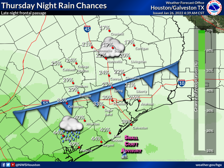
Some clouds will work their way into the region on Thursday ahead of the next cold front, so expect partly sunny skies during the morning, and grayer conditions as we get toward evening. Highs should reach the upper 50s for most locations, with light northeasterly winds. Overnight lows will drop into the low- to mid-40s. Some light rain is possible Thursday night as the front passes through early Friday morning.
A front on Thursday night will bring some modest rain chances to Houston. (National Weather Service).
Friday
Skies should begin to clear out in the wake of the front, but even with the sunny skies temperatures will crest in the mid- to upper-50s. This will be a somewhat chilly day, with winds gusting out of the north at or above 20 mph during the daytime. Lows Friday night will drop into the 30s in Houston, and a light freeze is possible for outlying areas.
Saturday and Sunday
The weekend looks tremendous for late January, with mostly sunny skies and cool, dry air. Look for highs near 60 degrees on Saturday, with overnight lows dropping to around 40 degrees, and highs in the upper 60s on Sunday.
Low temperatures on Saturday morning will be fairly chilly for the region. (Weather Bell)
Next week
As the onshore flow returns, look for increasing atmospheric moisture levels to spark a decent chance of rain through about Wednesday. Highs should eventually climb back into the low 70s before a front late on Tuesday or some time Wednesday brings more chilly weather back into the picture, with nights perhaps dropping back down to around 40 degrees. Look for rainfall accumulations of perhaps 1 inch next week, give or take.
Good morning. Although today will be our region’s warmest day until Sunday, the high temperature will probably not reach 60 degrees for some locations. Beyond the chillier conditions, and the potential for a light freeze on Saturday morning, there is not a whole lot to remark upon as Houston experiences fairly typical weather for this time of year. And if you like it, you’re in luck. After a brief warm-up early next week, this chilly weather could persist through at least the first half of February.
Tuesday
Temperatures will rise from the upper 40s this morning to around 60 degrees for much of the area today, but likely not go any higher due to mostly cloudy skies. A northerly flow will bring drier air into the region later today, and this will eventually erode cloud cover late today or tonight. As this drier and cooler air works its way into the region, expect temperatures to drop to around 40 degrees tonight, with cooler weather inland and warmer conditions along the coast.
Today will be the region’s warmest day until the weekend. (Weather Bell)
Wednesday and Thursday
These will be a pair of chilly winter days, with highs generally in the 50s, and lows in the 40s. Wednesday will see lots of sunshine, but Thursday should see the return of some clouds. Both days will probably see light northerly winds, with possibly a shift to southerly winds by Thursday evening.
Friday
Another cold front will arrive on Friday, probably during the morning, to shut down any kind of a serious warmup for the region. The atmosphere will be fairly dry so I’m betting against rain with this front, but it can’t entirely be ruled out. Winds will be breezy, out of the north, on Friday in the wake of the front and highs may struggle to reach the low 50s despite sunny skies. Temperatures will drop sharply on Friday night with clear skies and lessening winds. Much of the region away from the coast, and outside of Houston’s urban core, will probably see a light freeze on Saturday morning.
Saturday, Sunday, and beyond
Saturday is likely to be sunny, with moderate winds, and a high of around 60 degrees for most areas. This will be a fine winter day for any outdoor activities. Sunday should be partly sunny as well, with highs in the mid-60s as winds shift to come from the south. I think rain chances will remain near zero for most of Sunday, so this should be a fine day for outdoor activities as well.
Low temperature forecast for Saturday morning. (Weather Bell)
A warming trend will occur from about Monday through Wednesday of next week, with highs reaching perhaps the low 70s by the middle of the week. Rain chances look to be healthy all three of these days, with accumulations of perhaps 1 to 2 inches, but it’s way too early to say anything more specific than the pattern is likely to turn wetter. A front on Wednesday night, give or take half a day, is likely to bring colder and drier weather back to the region.
A few words on generators
I wanted to say a few words about generators this morning because now is the time to be thinking about such a project in advance of the 2022 Atlantic hurricane season. As demand for whole-home generators has surged following the great Texas freeze last February as well as COVID supply chain issues, there is now an industry-wide lead time of 8-9 months from initial inquiry to completed installation. While these times have begun to shorten, if you want to have peace of mind with backup power this summer and fall, now is the time to begin planning.
As you probably know, Reliant is a long-time sponsor of Space City Weather. They partner with a company called Quality Generators that offer a range of generator products, including whole-home generators. I had one installed last year, and the process was quite smooth. Buying a generator capable of powering your entire home is a major investment. For the average homeowner in Houston, it will likely cost between $10,000 and $15,000. But for many, it may be a worthwhile investment.
Here are a few other things to consider:
Quality Generators provides free assessments to determine the best generator for your home and power requirements.
If a whole-home generator isn’t right for your family, Reliant’s sister company Goal Zero provides portable backup power options that are great alternatives in cost and lead time.
On the topic of inclement weather incidents, Surge Protect is a service to help defray costs of making expensive, unexpected repairs to appliances and electronics damaged by electrical surges. This service is available to all Texas customers and can be added to Reliant residential customers’ monthly electricity bills.
Nearly two weeks ago, we predicted that the “rest of January” would feel rather winter-like for Houston. Since that time, with one exception, nighttime temperatures have been in the 30s and 40s. Now, it’s safe to say the rest of this month will remain on the colder side of things. This week will see high temperatures generally in the 50s, with lows in the 30s and 40s.
Monday
The story for today will be widespread rain showers due to the proximity of a low pressure system near the coast. During summer time, such a system would have greater atmospheric moisture levels to work with, so we’d be more concerned about heavy rainfall. In this case, however, most areas will likely pick up 0.5 to 1.0 inch of rain as light to moderate showers ebb and flow across the region. Coastal areas could see a bit more than this, but we’re really not expecting anything too extreme. With leaden skies, high temperatures today should peak in the mid-50s, before dropping into the upper 40s tonight.
NOAA rain accumulation forecast for now through Tuesday. (Weather Bell)
Tuesday
Rains should end on Monday evening as the system pushes off to the east, and this will help to pull in a surge of cooler and drier air on Tuesday. Temperatures should reach about 60 degrees in Houston on Tuesday, with partly to mostly cloudy skies and northerly winds, before lows Tuesday night drop to around 40 degrees.
Wednesday and Thursday
These should be a pair of partly to mostly sunny days, with highs in the mid-50s and overnight lows dropping into the low 40s.
Friday, Saturday, and Sunday
Another front should arrive on Thursday night, possibly bringing some more light rain into the area. This front will help keep temperatures on the cool and sunny side for most of this weekend, with highs in the 50s on Friday and Saturday, and perhaps the mid-60s on Sunday. It looks like Saturday morning will bring the coldest temperatures this week, with a light freeze possible for much of the area.
Saturday morning should be the coldest of the week. Here’s a preliminary forecast for temperatures. (Weather Bell)
This time there likely will be no front to end the warming trend, so temperatures should jump up into the 60s or perhaps lower 70s by Monday, and we may also see an increase in rain chances later on Sunday and into Monday, but the details of all this will remain fuzzy for now.
The bottom line is that as the calendar turns toward the end of January, we’re really into the depths of winter for Houston now, and weather this week with consistently “cold” days is going to feel like it for our southern region. Enjoy or disapprove at your discretion!
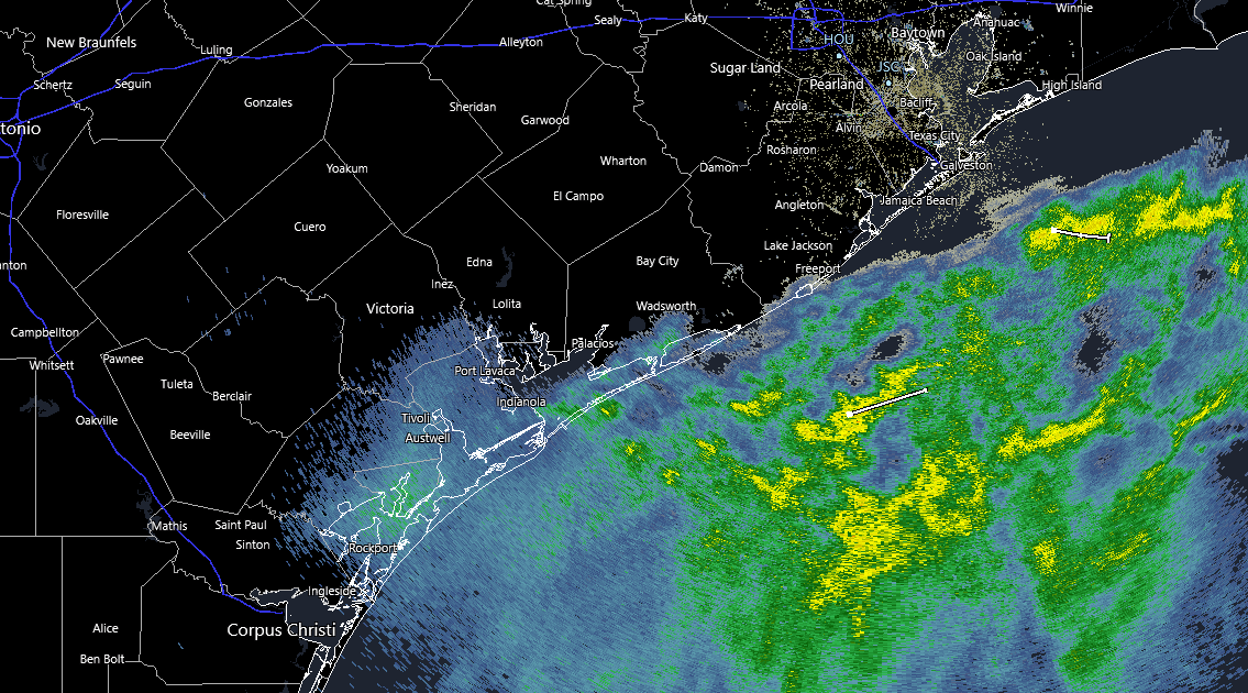
Some lingering rain or sleet may occur in the Matagorda Bay region until a little after sunrise, but everyone else should just be waking up to clouds.
Radar as of 6 AM shows the only precipitation left along the immediate coast. Everything is moving offshore. (RadarScope)
Those clouds will clear from northwest to southeast this morning and afternoon. I’d venture to say at least 90 percent of the area will see sunshine before the day is up, with the exceptions maybe being along the immediate Gulf coast. Despite developing sunshine, most places probably won’t get out of the 40s today. Coupled with a light to moderate breeze, it will feel chilly.
Weekend
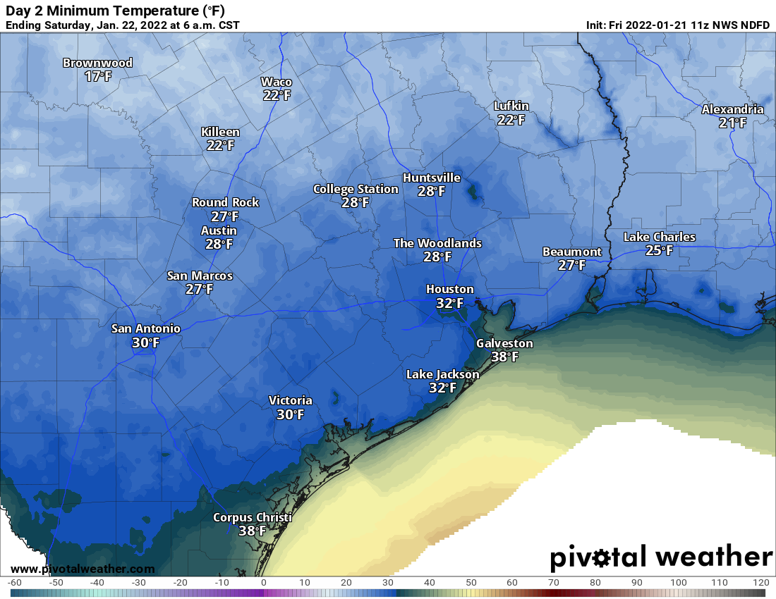
Tonight will be the coldest night of this cold snap. Skies should be clear and winds light, or what meteorologists refer to as “ideal radiational cooling.” It means temperatures will fall steadily after sunset, and we should bottom out in the 20s and low-30s across the region tonight.
Tonight will be a cold one across the area with a freeze likely for most areas away from the immediate coast. (Pivotal Weather)
Look for a low right around freezing inside the Beltway, 29-31° outside of there to Grand Parkway, and generally upper 20s beyond that. As always, slightly higher or slightly lower temperatures are possible based on your location, but it should not get any worse than that. It’s probably a good idea to protect any sensitive plants, particularly outside the Beltway, but we don’t expect any serious problems. If you’re looking for a benchmark, this freeze looks similar in a lot of ways to the ones we had earlier this month, just after New Years. Another freeze will be possible Sunday morning, but it would be most likely north and east of Houston and a degree or so warmer than tomorrow’s.
The rest of the weekend looks splendid, with plenty of sunshine Saturday and some high clouds on Sunday. Expect highs in the lower half of the 50s Saturday and upper-50s on Sunday.
Monday
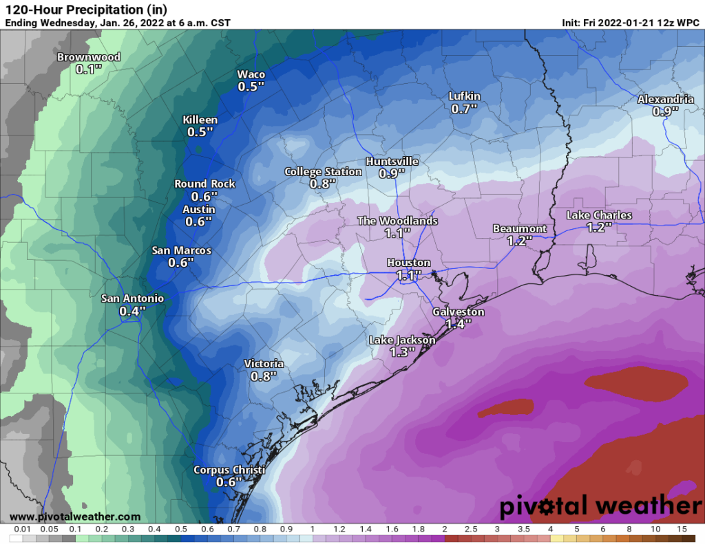
A quick moving, vigorous disturbance is going to pass by the region Monday afternoon and evening. Expect clouds to increase Sunday night into Monday morning. Rain will begin to develop and spread from southwest to northeast across the region later Monday morning into the afternoon. The heaviest rain looks to be around mid to late afternoon, and then it will taper off Monday evening. At this point, it looks like a good old fashioned soaking rain, something most of the area needs right now. There is some chance we’ll get some thunderstorms embedded within the rain as well, and some stronger storms can’t yet be entirely ruled out. But that is not the expectation right now. Check back with us Monday morning for the latest.
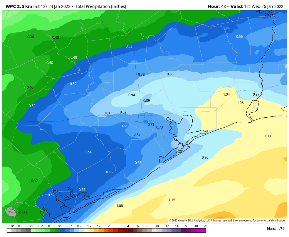
Most of the area should receive at least a half-inch to an inch of rain from Monday’s system, with some higher amounts possible south and east. (Pivotal Weather)
We should be able to muster a solid half-inch to inch of rain across most of the area, as long as the current forecast holds. The highest totals should be south and east of the city. Monday will warm from the 40s into the mid-50s.
Rest of next week
Look for a warm day with sunshine on Tuesday, as highs should get back into the 60s. A cold front should uneventfully pass through the region Tuesday night, yielding some more 30s for lows by Thursday morning and highs in the 50s Wednesday and Thursday. A freeze is not expected outside of perhaps typical colder spots like Conroe, Huntsville, Cleveland, or west of Katy. Skies should be partly to mostly sunny. A general warming trend will likely begin after that cold front, which could return us to more frequent above normal temperatures again by early February. Stay tuned!