A breezy, cold 2022 Houston Marathon ahead

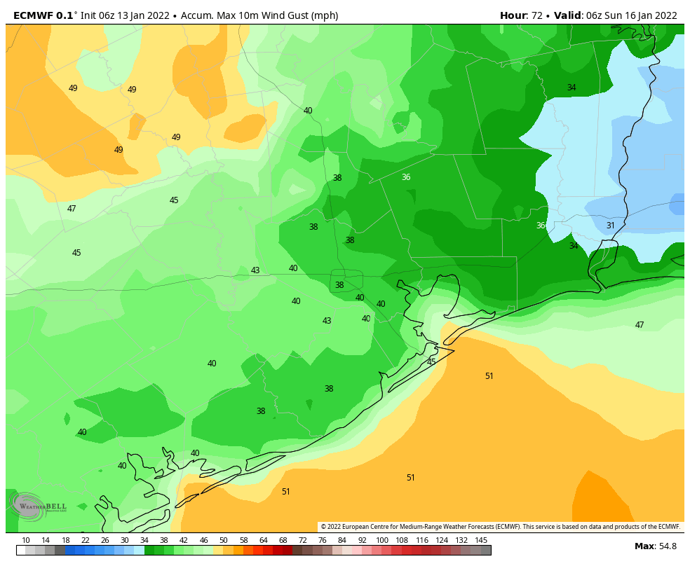
We’ll be in for a weekend of change, and it will be obvious when it hits, as winds should be pretty gusty behind tomorrow’s cold front. That said, this will be pretty typical for a Houston winter weekend, and much of the forecast ahead will resemble a fairly typical winter here. For those of you running the Houston Marathon (or the half or 5k) this weekend, first off, good luck! Secondly, the winds on Sunday, while not as bad as tomorrow afternoon, will certainly come with some bite. With a 15 to 20 mph northwest wind and temperatures in the 30s on Sunday morning, it will feel like it’s in the 20s to start the race.

Forecast wind chills on Sunday morning will be in the 20s with actual temperatures in the 30s to start the race. (Pivotal Weather)

Thankfully, as temperatures warm up through the morning, the wind should slowly back down. By 10 AM, winds will be back down around 15 mph with temperatures in the 40s, making it feel more like the mid to upper-30s. It should be mainly sunny for the race, so at least you’ll have that.

Today

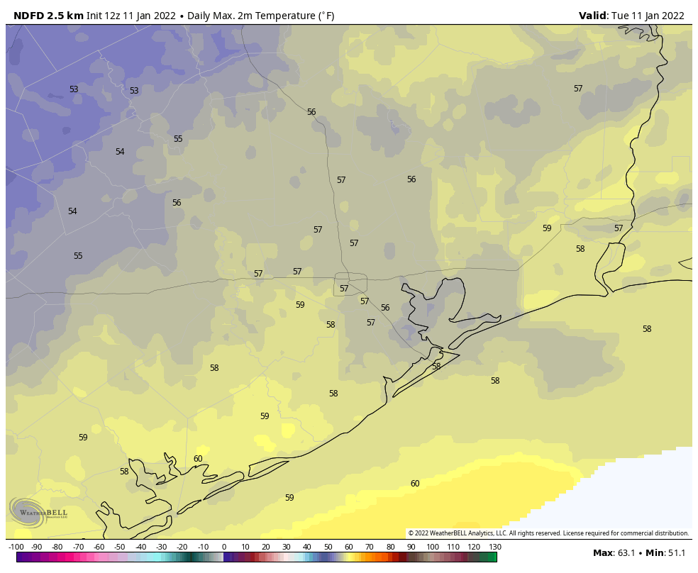
Before we get to Sunday, we have to get through today and tomorrow. Look for a warm one with sunshine for Friday and highs in the low, maybe mid-70s. There is some patchy fog along the coastal plain this morning, mainly south of Houston, so if your travels take you down 288 into Brazoria County or toward Matagorda County, just be aware of that through about 9 or 10 AM.

Saturday

Tomorrow’s cold front should pass through the region in the early morning hours, probably around or just before sunrise. Look for a sharp wind shift with sustained winds of 20 to 30 mph and some higher gusts.

Maximum wind gusts on Saturday should peak around 30 to 35 mph in a lot of spots, with 40 to 45 mph gusts near Galveston Bay or at the coast. Interior areas west of Houston may also see some 40 mph gusts as well. (Weather Bell)

This shouldn’t be widespread power outage stuff, but you might see a few reports of brief outages due to wind. Winds will be gustier along the coast, so Galveston and communities along Galveston Bay could see gusts of 40 mph or so.

Along with the winds will come falling temperatures. Saturday’s high will be achieved around daybreak, with temperatures falling through the 50s and into the 40s on Saturday morning. We’ll level off some for afternoon and maybe even warm back up a tick or two.

This front will come with limited ability to produce storms, so look for perhaps a broken area of showers in the early morning, mainly south and east of Houston. Most areas are unlikely to see measurable rainfall.

Sunday

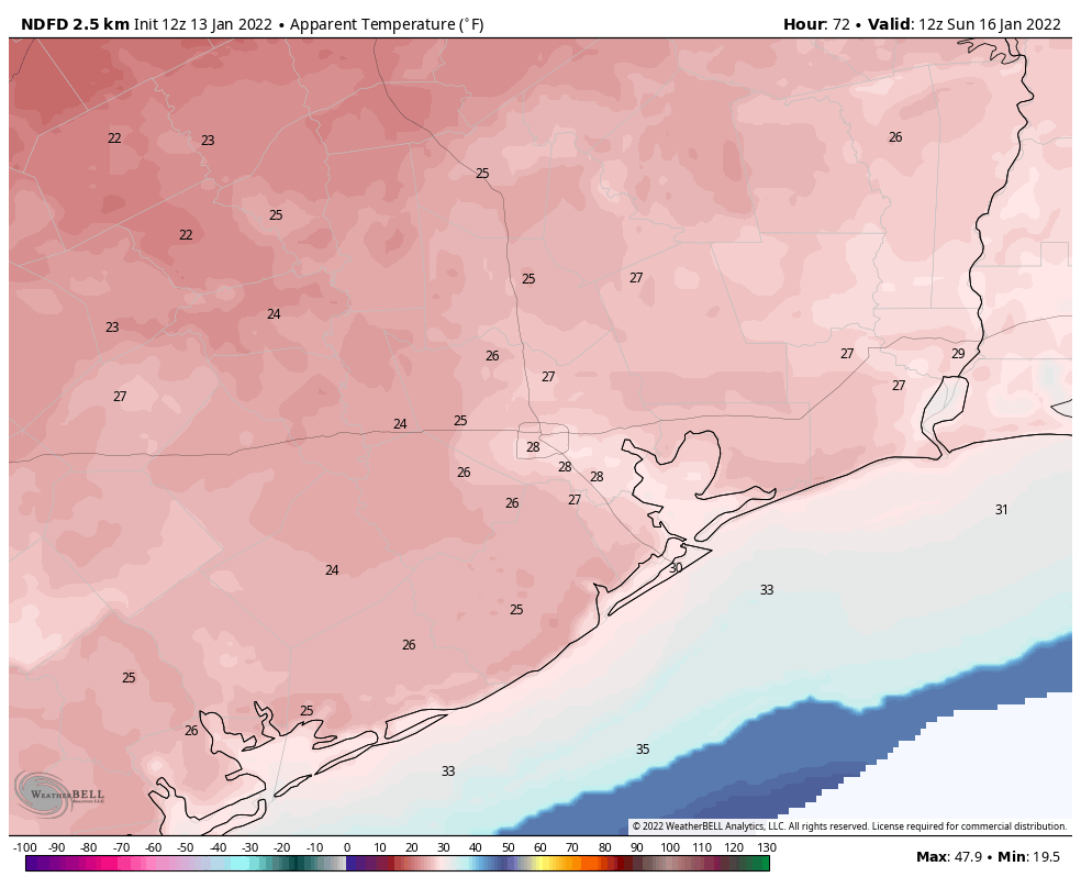
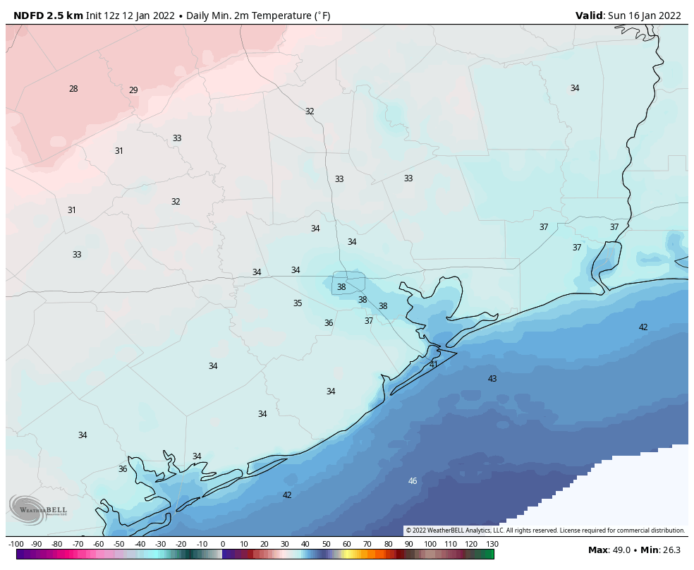
As noted at the top, it will be cold on Sunday morning with 30s in most spots. A light freeze is a good bet outside the metro area, but the wind will actually help prevent that from being too widespread. Places like Conroe or Navasota or Cleveland or Brookshire could still see lows get close to freezing for a couple hours. Everyone else should see mid to upper-30s with that breeze. The day should be nicer with highs into the 50s and ample sunshine.

Early next week

Look for quiet weather on Monday and Tuesday. Most places will be back in the 30s on Monday morning, but a freeze is unlikely in most spots. With sunshine, we’ll warm into the 60s for the Martin Luther King Jr. Day holiday. Onshore flow resumes on Tuesday, allowing us to slowly warm, so expect lows in the 40s in the morning, warming into the 70s in the afternoon. Our next front is penciled in for Wednesday.

Late next week

Look for a fairly unsettled weather pattern to take hold for Thursday and Friday, which could lead to some rain across the area, perhaps focused mainly on the southern half of the region. Temperatures will likely stay cool behind Wednesday’s front, with perhaps a reinforcing front next weekend to usher in some even colder air by Sunday or Monday. Again, there is no realistic sign of any kind of massive cold outbreak or deep freeze (the pattern setting up over North America next week favors the strongest cold relative to normal to aim at places like Buffalo, Chicago, and Minneapolis right now, not the Plains/Texas). But it will likely be chilly regardless, and there will probably be more than one opportunity for a night of below freezing temperatures in Houston.

Speaking of Buffalo, if you’ll be watching the Bills/Pats game this weekend, it’s going to be a brutal one in Orchard Park. Saturday evening’s kickoff temperature should be about 5 degrees, give or take.

More for you Monday!

Houston’s weekend will be sunny, windy, and quite chilly

Houston will experience two pleasant, mostly sunny days before a cold front barrels into the region early on Saturday. This will set the stage for a chilly and blustery weekend, with temperatures near freezing across much of the area on Sunday and Monday mornings. Beyond the cool weather, there are no concerns for the week ahead.

Thursday

Conditions today will be pleasant, with sunny skies and moderate westerly winds. Expect highs to reach about 70 degrees. Low temperatures tonight will drop into the upper 40s in Houston, with slightly cooler conditions further inland, and a bit warmer along the coast.

Friday

Winds will shift to come from the south on Friday, perhaps gusting to around 15 to 20 mph during the afternoon hours. This will allow for a slightly warmer day, with highs in the low- to mid-70s. Skies should remain mostly to completely sunny, however. Clouds begin to build overnight, with temperatures likely holding in the mid-50s.

Forecast for maximum wind gusts on Saturday afternoon in the Houston region. (Weather Bell)

Saturday

The timing of this weekend’s cold front has advanced a little bit, and it now appears as though it should reach western areas during the pre-dawn hours on Saturday, central Houston by around sunrise if not before, and push off the coast by 7 to 9 am. Some scattered, light showers are possible with the front near the coast, but for the most part is should be a dry passage. In the front’s wake, winds will kick up out of the north at about 20 mph, with gusts as high as 30 to 40 mph. These winds will likely peak during the afternoon and early evening hours. Temperatures on Saturday afternoon will probably hover in the mid-50s, dropping quickly during the evening and overnight hours.

Sunday

Lows on Sunday morning will likely start out in the mid-30s. Winds should subside some overnight, but during the pre-noon hours on Sunday we should still see some gusts of about 20 mph, and this will make the morning feel very brisk indeed. If you’re participating in the Houston Marathon, please dress accordingly, as morning wind chill temperatures should be in the 20s. High temperatures on Sunday, beneath sunny skies, will likely peak in the mid-50s before another cold night with temperatures dropping to the mid-30s in Houston, with a freeze possible for outlying areas.

Wind-chill temperatures on Sunday morning will reach the 20s. (Weather Bell)

Next week

We’ll see a gradual warm-up through about Wednesday of next week, with highs likely reaching the low- to mid-70s before some kind of front arrives. Light rain is possible with the front, which should knock overnight lows into the 40s or possibly even 30s for the second half of next week. As ever, details are to come.

Looking ahead, most of January should be fairly cold in Houston

For now there’s no indication of extremely cold weather, but the rest of January does look to be rather winter-like for Houston. While there may be the odd 70-degree day, for the most part we’ll be colder during the daytime, with plenty of nights in the 30s and 40s. A freeze is possible as soon as Sunday morning in outlying areas of the region, and it will definitely make for a cold Houston Marathon.

Wednesday

Temperatures have fallen to around 50 degrees this morning, and with a fair amount of cloud cover they’ll be slow to rise before noon. But with more sunshine this afternoon, I’d expect much of the region to see high temperatures in the low- to mid-60s. Light northeast winds will turn more westerly this afternoon. With clearing skies later today and tonight, most areas should see low temperatures drop into the 40s overnight.

Thursday and Friday

These will be a pair of splendid days, with sunny skies and highs between 70 and 75 degrees. Overnight lows will range from the upper 40s to low 50s, for the most part, with generally moderate winds. Dewpoints will creep into the upper 50s by Friday afternoon or evening, so it will feel a bit humid, but overall these will just be wonderful weather days for the region. Enjoy!

Forecast for maximum wind gusts on Saturday after the front’s passage. (Weather Bell)

Saturday

Change will arrive by Saturday morning, with a strong front pushing into northwest areas probably sometime around sunrise or shortly thereafter, into Houston during the mid-morning hours, and arriving near the coast around Noon. It’s likely that the front’s passage will be a dry one, or with only a bit of light rain, but with plenty of wind. Gusts on Saturday afternoon may well get above 30 mph as temperatures hover in the 50s despite sunny skies. Winds will continue to blow on Saturday night as lows drop into the upper 30s in Houston.

Sunday

The good news if you’re running the marathon is that we can be highly confident in dry conditions, both in terms of humidity as well as clear skies. For those who like the cold, Houston Marathon start line temperatures will be rather chilly, too. Expect the mercury to be somewhere between 35 and 40 degrees. The less good news is that while winds will slacken some from Saturday, I think we’ll still see a persistent northerly wind on Sunday morning of about 10 mph, with gusts from 15 to 20 mph. That is less than ideal for both runners and all the amazing volunteers at the marathon. Highs will climb into the 50s during the afternoon. Lows will drop into the 30s on Sunday night, with some inland areas again seeing a light freeze.

Low temperatures on Sunday morning. (Weather Bell)

Next week

Temperatures will gradually warm next week through about Wednesday, when the next front arrives. This one has a better chance of producing some rainfall, but nothing that looks too crazy in terms of amounts. Lows should drop back into the 40s toward the weekend.

Houston to see solidly winter-like weather for awhile now

Good morning. Temperatures range from near freezing in Montgomery County to the upper 40s along the coast on what should be our coldest morning until at least Sunday. Houston’s basic pattern is pretty well locked in, with a slow warming trend from now through Friday, before the next front arrives and makes for a cold and breezy weekend ahead.

Tuesday

Today will not warm up a whole lot, as an upper-level disturbance will help to generate some cloud cover. As a result, expect highs to only reach into the mid- to upper-50s, and with light to moderate winds out of the northeast it will feel fairly chilly outside. There is a slight chance of showers this evening, although I think our air mass is dry enough that an upper-level low probably won’t produce any measurable rainfall for most areas. Lows tonight should be a couple of degrees warmer than Monday night due to the cloud cover.

Tuesday will be partly cloudy and somewhat chilly. (Weather Bell)

Wednesday

We’ll see a mix of clouds and sunshine on Wednesday, and local temperatures will depend on how much sunshine breaks through. Overall, highs somewhere between 60 and 65 degrees seem a good bet for most locations. As skies clear tonight, most of the region should again see temperatures drop into the 40s on Wednesday night.

Thursday and Friday

As the high pressure system moves off to the east during the middle of the week, we’ll start to see a warmer flow for Thursday and Friday, both of which will probably be mostly sunny days with highs in the vicinity of 70 degrees.

Saturday, Sunday, and beyond

Saturday morning will probably start out fairly mild, with temperatures in the low 50s, before the next cold front arrives. I think it will likely reach the Houston metro area sometime between sunrise and noon, although that’s not locked in. Some brief, light rain is possible with the front although for much of the area it looks to be a dry passage. Saturday afternoon and evening look breezy, with temperatures in the 50s and gusts of perhaps 20 to 35 mph.

Early-look forecast for wind gusts on Saturday afternoon show fairly blowy conditions across the region. (Weather Bell)

By Sunday morning, lows likely will drop down to around 35 to 40 degrees in downtown Houston—a good incentive to keep running during the marathon. Winds, fortunately, should begin to subside somewhat by Sunday morning, although they will continue to blow from the north at perhaps 10 mph. Highs should climb into the mid-50s beneath sunny skies, with another night of temperatures in the 30s for inland areas, and 40s along the coast.

A warming trend then begins on Monday for the region, with another front possibly moving through some time on Wednesday, and perhaps bringing somewhat better rain chances with it