Deep chill moves into Houston, bringing threat of light freezing rain Thursday night

Good morning. The cold front has pushed off the coast, and temperatures have fallen into the upper 30s to low 40s for most of the region. Our primary concern remains the potential for rainfall to turn into wintry precipitation this evening, and during the overnight hours. Secondarily, we are worried about cold temperatures on Thursday night falling below freezing, with wind chills in the low teens. Please protect your pets, and check on neighbors.

Thursday

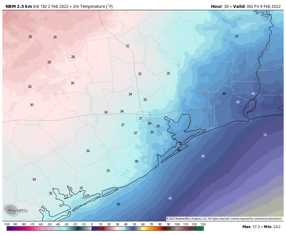
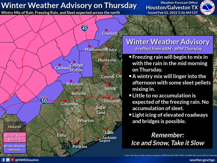
Today will be cold, wet, and windy, with light to moderate precipitation winding down through the morning hours. Expect high temperatures to remain at about 40 degrees or slightly higher this afternoon, with northerly winds gusting to 25 or 30 mph. Rain remains possible this afternoon, although showers should be very light. There are two main forecast questions that we’re struggling with, and they’re both important to determine impacts from later today into Friday morning. First of all, how quickly will a freezing line advance from northwest of the Houston metro area down toward the coast? And secondarily, when will the precipitation end altogether?

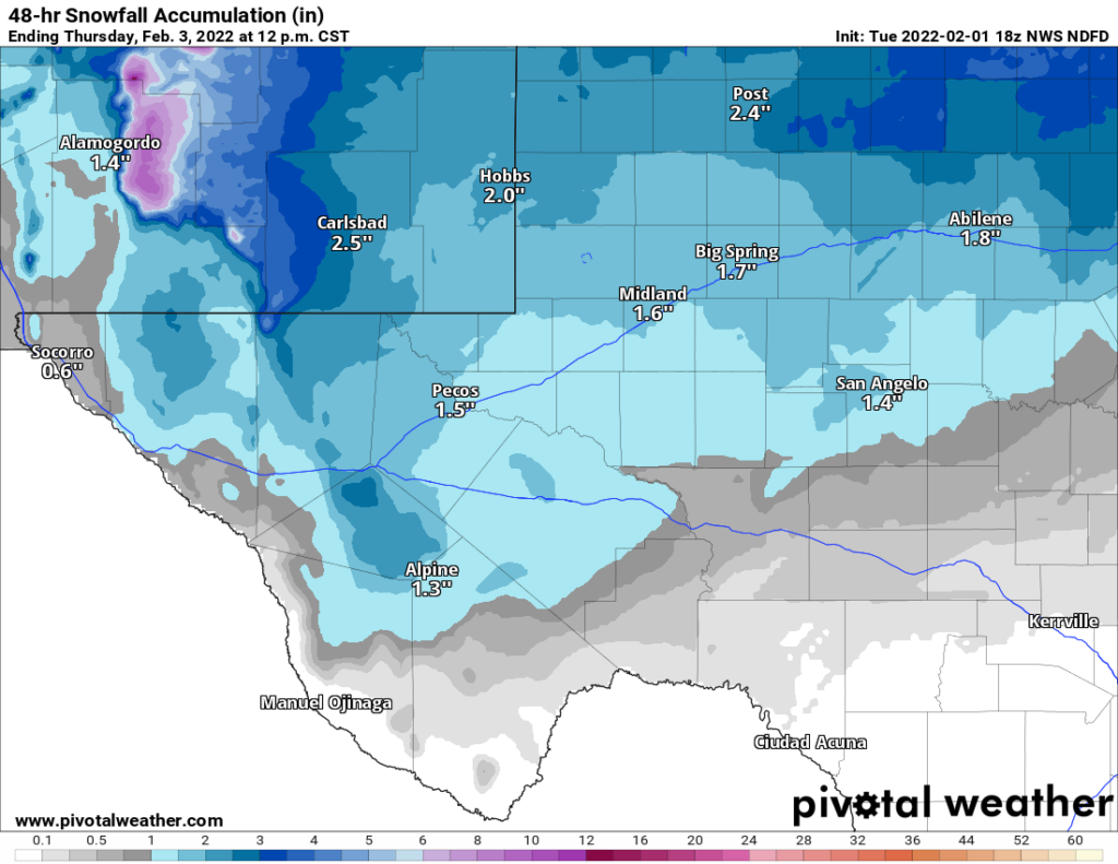
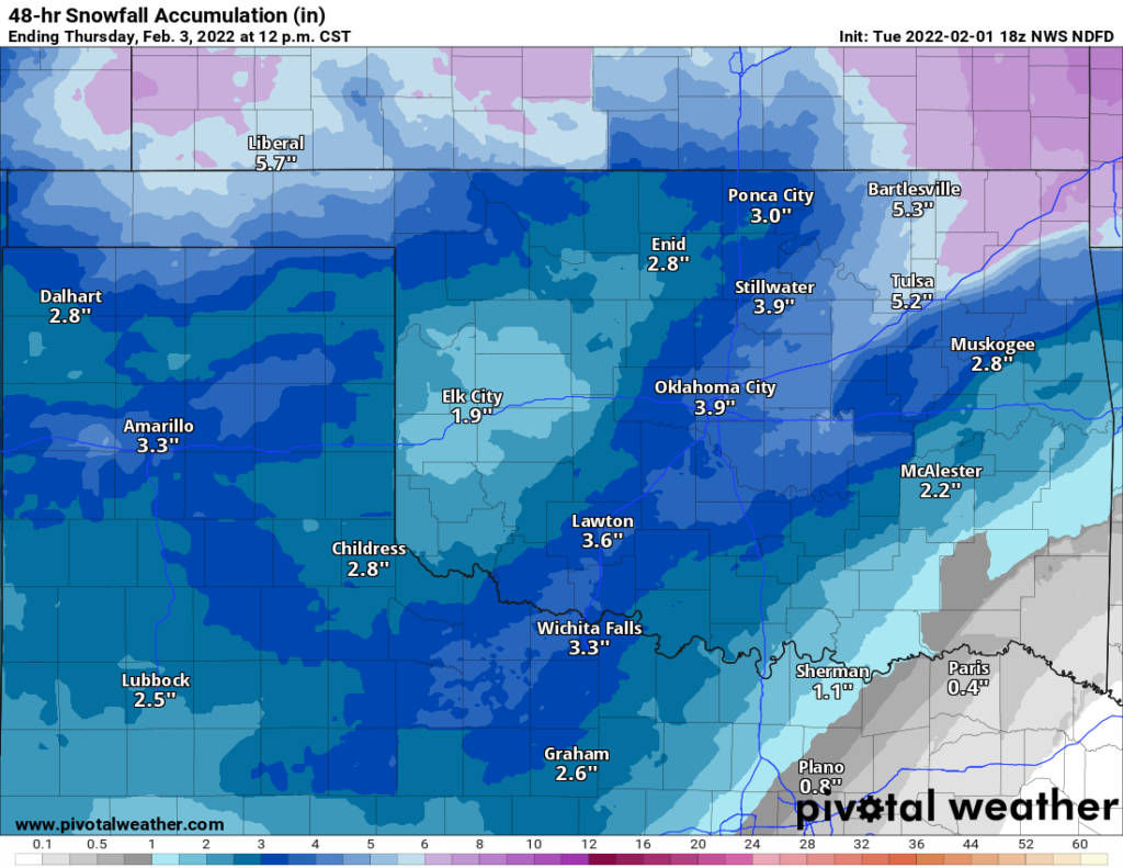
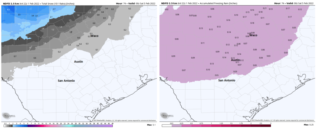
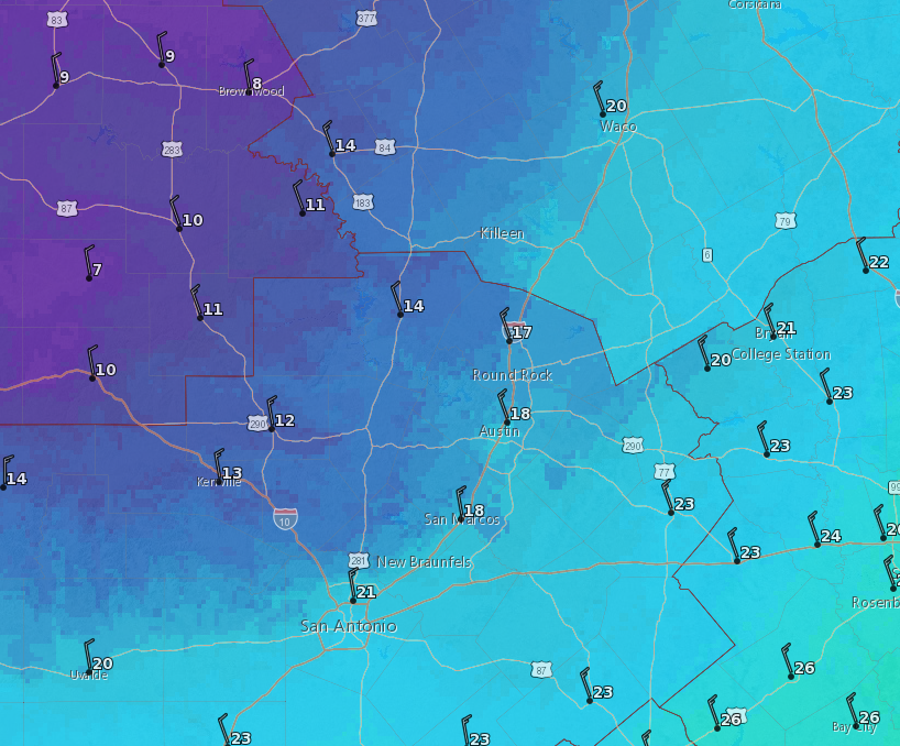
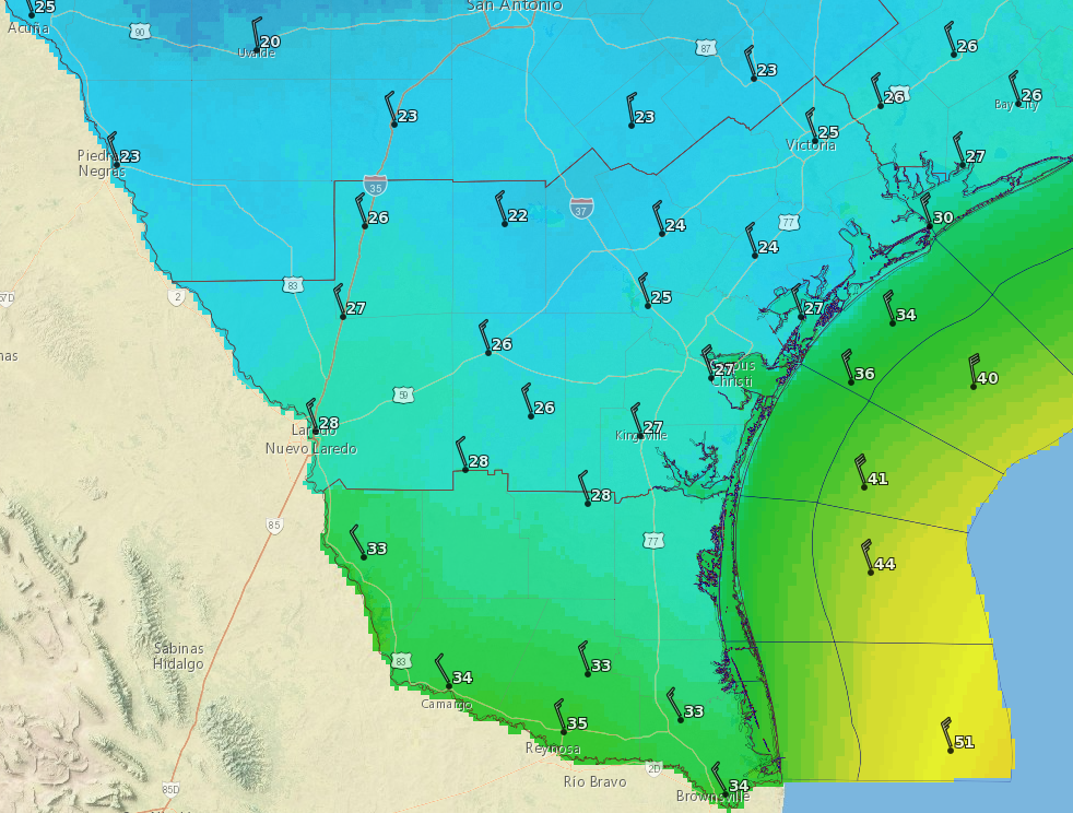
Most likely, the freezing line will reach western parts of the metro area, including Katy; and northern parts, including The Woodlands; sometime this afternoon or shortly after sunset. This means that travel through Houston should be fine today and likely through the evening commute unless you’re going north of Conroe or to places northwest, beyond Hempstead. For more inland parts of the state, including Austin and Dallas, there are fairly serious icing problems today. You can check highway ice conditions at the Texas Department of Transportation’s Drive Texas website.

Icy conditions have already developed in central and northern Texas this morning. (DriveTexas.org)

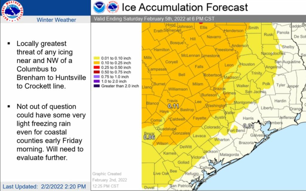
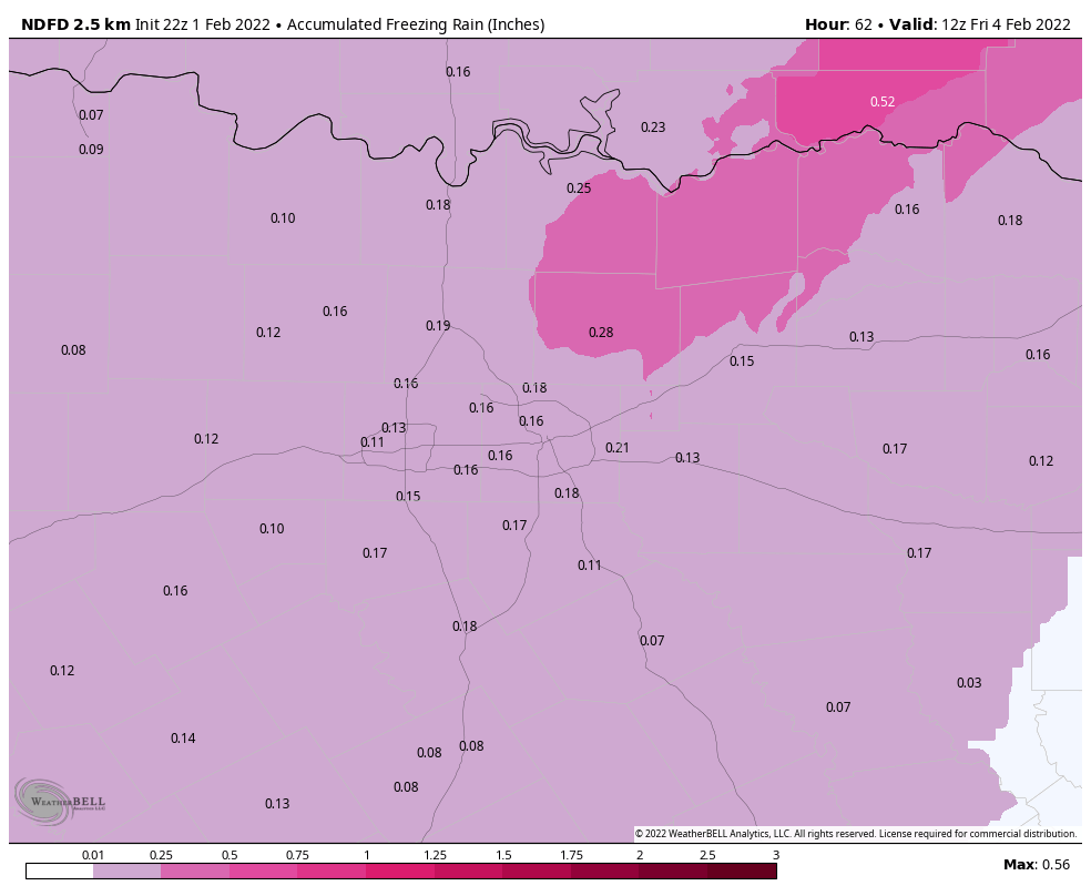
As the freezing line moves in, it looks as though very light precipitation may still be falling this afternoon, evening, and overnight. Our primary concern is that this will leave a thin glaze of ice on elevated roads and bridges into Friday morning. Within the Houston metro area, my sense right now is that essential travel will still be possible if you go slow and use caution. However, it does not take too much freezing rain to make a mess of things. The latest models have trended a bit drier in terms of overnight precipitation, which gives me some hope that ice accumulation is not going to be a significant problem in Harris County and most of the immediate area surrounding Houston. But again we’re walking a pretty fine line here. Matt and I will update the site a couple of more times today to bring you the latest data we have on this.

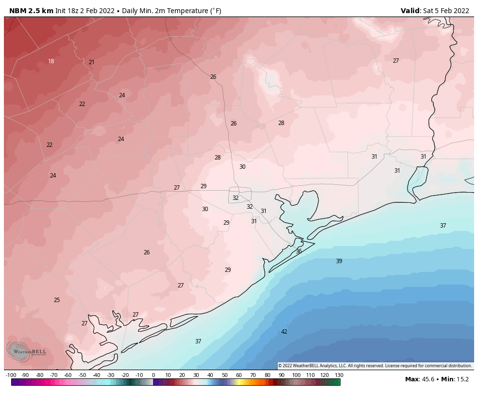
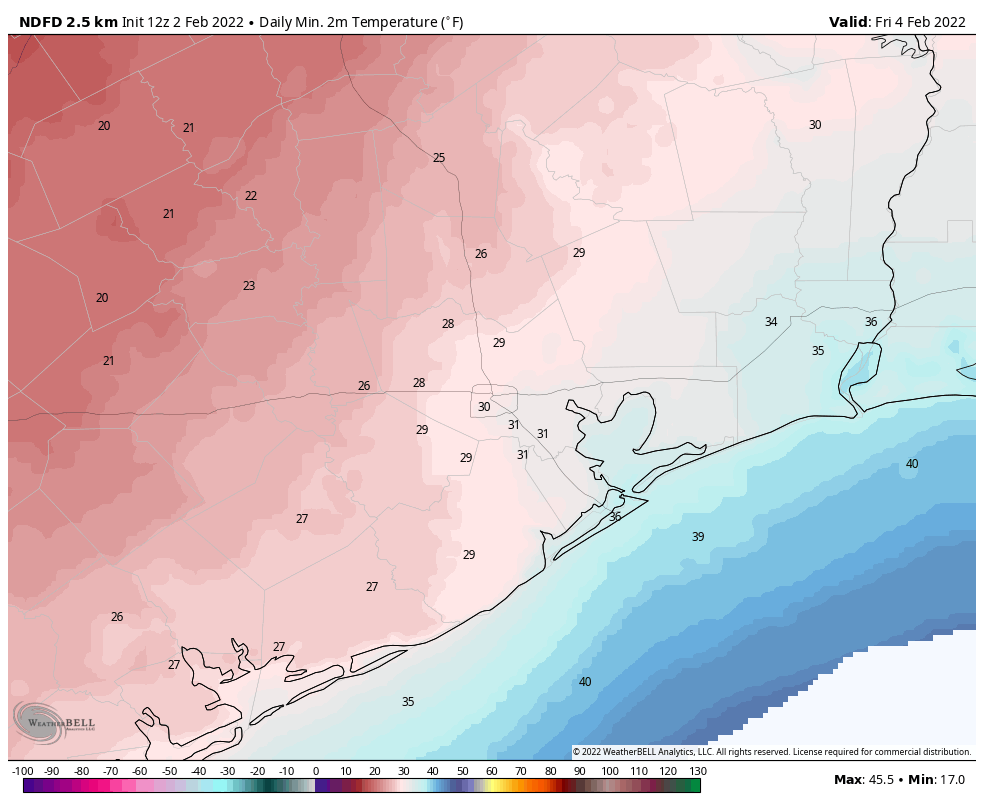
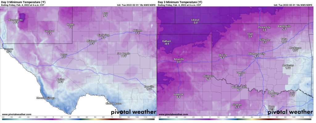
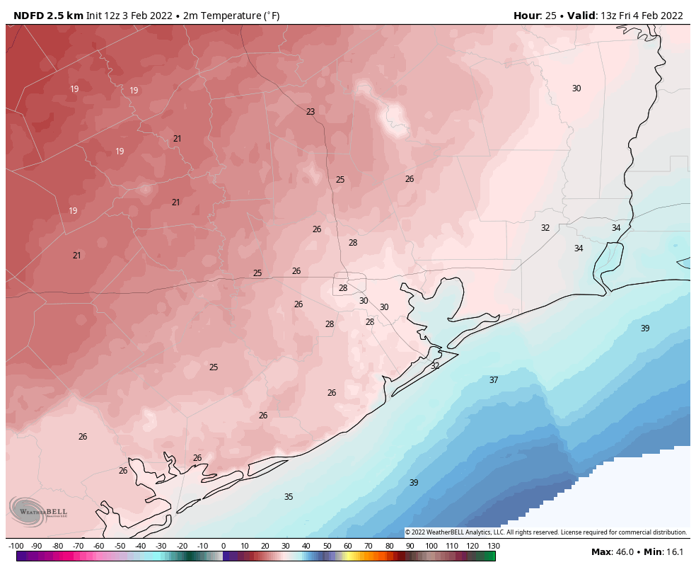
It looks like overnight temperatures will drop into the mid- to upper-20s for much of the Houston area, with the coast remaining near or just above freezing. Combined with winds, this will make for extremely cold conditions out of doors, but we don’t think it will cause widespread issues with pipes. So far the state’s power grid is holding up well, with electricity capacity far exceeding demand. We think that will continue to be the case tonight and into Friday, but can offer no guarantees.

Low temperature forecast for Friday morning. (Weather Bell)

Friday

So what can we expect roadways to look like Friday morning? This will depend on precipitation overnight, and right now our expectation is that there may be a light glaze on elevated roads and bridges. There is a chance for more significant ice accumulations, but as I look at the data right now that seems unlikely. Temperatures should rise above freezing during the mid- to late-morning hours, after which the threat of any ice on the roads will quickly abate. A winter weather advisory from the National Weather Service is in effect through noon Friday. High temperatures on Friday won’t go far—perhaps only to 40 or 42 degrees—but they’ll go far enough. With partly cloudy skies we can expect another cold night, with a light freeze possible in Houston.

Saturday

The first day of the weekend will be sunny and cold, with highs in the upper 40s. Winds should finally die down some, but this in turn will yield ideal conditions for cooling overnight, so a light freeze will again be possible for much of the metro area.

Sunday

Sunny with highs in the mid-50s. Lows Sunday night should finally remain above freezing for all but some areas in Montgomery County and points north.

Next week

For the most part we should see sunny weather next week, with highs in the 60s and lows in the 30s and 40s. Rain chances are low for the most part. So cold, but not extremely cold.

Arctic front on track for Houston tonight, will bring cold air and a chance of freezing rain

Good afternoon. As we get closer to the arrival of a robust cold front tonight, we’re getting better data about its impacts. It now seems possible that light precipitation on Thursday or Thursday evening could transition to freezing rain in parts of the metro area as temperatures fall to freezing. We still believe this will most likely have relatively minor impacts on the region, but cannot say that with full confidence right now.

The front will arrive in western and northwestern parts of the metro area this evening, including locations such as Katy and Tomball, between 9 and 11 pm. The front will reach downtown around midnight, and the coast around 2 to 4 am. The most noticeable changes with the front will be a wind shift and rapidly dropping temperatures. While intermittent, moderate rain showers will be possible after the front, the heaviest rains should end by Thursday morning-ish.

Temperature forecast for sunset on Thursday. (Weather Bell)

What we’ll be watching for on Thursday is the progression of a freezing line from northwest to southeast; from College Station through Houston, and potentially all the way to the coast. The latest modeling suggests this freezing line will reach College Station by mid- to late-morning on Thursday, and areas such as Katy and The Woodlands during the afternoon or early evening hours. At this point, while the heaviest rain showers will have ended, a light band of precipitation is expected to sag through our region Thursday evening and overnight. As this rain moves through it may transition to freezing rain on Thursday night all the way down to the Highway 59/Interstate 69 corridor, if not a little further.

Ice accumulation forecast. (National Weather Service)

What does all this mean? Travel in the College Station and Huntsville region could become hazardous later on Thursday morning, with some minor ice accumulations on roadways. In the metro area of Houston, travel during the daytime and early evening should be fine. But some slight ice accumulations are possible later Thursday evening and during the overnight hours. Because roads will still carry some latent heat, the biggest threat for any ice accumulations in Houston will be on elevated bridges and overpasses. Even this ice threat should dissipate as local temperatures rise above freezing by around 9 am on Friday morning.

Most probable low temperature forecast for Friday morning. (Weather Bell)

It still looks like air temperatures will not fall all that far below freezing in the Houston area on Thursday night. Please understand that this is not going to come close to the deep freeze Houston experienced in February 2021, so please do not be overly concerned about that. There is also some reason to believe that the state’s power grid will be able to withstand this freeze, but obviously time will tell.

As this is a fairly dynamic event, things may change, and when they do we’ll report what we know, when we know it.

A message from Reliant

With the winter weather expected this week, Reliant wants to help make sure Texans are prepared. We’re glad to be a longtime supporter of Space City Weather and its mission to keep us informed in advance of weather events headed our way.

Below are tips that can make a big impact when temperatures dip below freezing:

  • Charge your devices. Make sure your cell phone, medical equipment, tablets and laptop are fully charged ahead of time.
  • Have a backup. Additional power sources can keep your home powered in case of an outage.  Keep in mind winter weather can result in local outages caused by things like ice on wires or fallen tree limbs. These local outages are not related to the amount of available electricity generated and put on the grid. Texans should contact their transmission and distribution utility in the event they experience a localized outage.
  • Download the Reliant Winter Prep checklist. Learn more ways to get your home and vehicle ready for dropping temperatures.


Reliant provides 24/7 support to customers via phone and online chat.

An Arctic front comes tonight, but we don’t think it will be too extreme for Houston

Good morning. The overall forecast remains on track for Houston, with a strong Arctic front moving into the region tonight and setting up several days of colder weather. I still don’t things will get too extreme for Houston—much of the city probably will not see a hard freeze—but this winter storm will nonetheless have widespread effects across the state. Matt covered a lot of these issues in a post on Tuesday night.

Also, I’m not sure exactly what it means when the groundhog sees not his shadow, but rather the shadow of death, but I guess we’re about to find out. This is because Milltown Mel, a weather-predicting groundhog in New Jersey, died on the day before Groundhog Day. So, yeah.

Wednesday

Fog is draped over much of the region this morning as air temperatures, generally in the mid-50s, have fallen to the dewpoint temperature. This fog will burn off as air temperatures rise today, and we’re probably going all the way into the low 70s even though skies will be mostly cloudy. Winds will be light, from the east, at 5 to 10 mph. Some scattered, light showers will be possible this morning, and into the afternoon hours, but I think the better rain chances will come over night along with the front. Said front will arrive in northwest parts of the region by around 8 to 10 pm on Wednesday night, should reach downtown around midnight, and push down to the coast around 2 to 4 am.

This dewpoint forecast shows the front’s position at around midnight tonight. (Weather Bell)

Thursday

It will be a different world when you wake up Thursday morning, with air temperatures around 40 degrees, gusty northerly winds, and possibly some ongoing precipitation. The bottom line: It will be cold, windy, and possibly wet. High temperatures should hold at about 40 degrees during the daytime, and the possibility for some very light precipitation will linger throughout the daytime. What does this mean for our region? Well, it’s possible that areas northwest will see a mix of sleet and ice pellets during the daytime. A Winter Weather Advisory is in effect for Burleson, Brazos, Houston, Madison, Washington, and Grimes counties through 6 pm. Closer to Houston, we may see some sleet or freezing in the air, but surface temperatures should be warm enough to preclude any impacts on the ground. At this time we don’t anticipate significant impacts in the city and surrounding counties.

Area showing a “winter weather advisory” for areas immediately northwest of Houston. (Weather Bell)

Another big question remains how cold it will get on Thursday night. It’s looking like clouds and winds of 15 to 20 mph should help keep the extreme cold at bay, with temperatures in the mid- to upper-20s in places like Montgomery County and west Harris County, and temperatures in the upper 20s to freezing in Houston and down to the coast. These temperatures should be warm enough to preclude bursting unexposed pipes.

Low-temperature forecast for Friday morning in Houston. (Weather Bell)

Friday

This will be a cold, mostly cloudy day. Highs should peak in the upper 30s to 40 degrees, but a northerly wind will make it feel colder. But at least it will be above freezing. With more clouds on Friday night, lows should drop to about their same level as Thursday night, plus or minus a degree or two.

Saturday

Sunshine, finally. Clearing skies should help temperatures rise into the upper 40s to 50 degrees, and we’ll probably all welcome the lack of a stiff northerly wind. Lows Saturday night, under clear skies, should drop to around freezing in central Houston, with slightly cooler conditions for inland areas.

Sunday

The second half of the weekend looks quite nice, with highs in the mid-50s and ample sunshine. Most of the area should avoid a freeze on Sunday night.

Next week

Temperatures will be slow to warm as we head into next week, but highs should reach the low 60s by Wednesday or so, with lows in the 40s. Days should be partly to mostly sunny, with a mostly northerly flow. If you enjoy winter in Texas, be sure and get your fill.

Winter storm impacts expected all across Texas

Eric has been keeping you apprised on local impacts due to the upcoming cold snap and winter storm, which at this time appear to be relatively minor. We often get asked about weather across other portions of Texas, as people plan travel or have friends and relatives elsewhere. In this post, we’ll talk a bit more about what is expected weather-wise across the Lone Star State from this significant winter storm. It’s important to again underscore that this is not a February 2021 repeat, even elsewhere in Texas. All events have unique impacts. It’s not a reason to take events like this lightly, as this one will cause some significant problems I am sure, particularly related to travel. But it’s important for us to provide some context for you, and that context is that this is a not a February 2021-type event virtually anywhere in Texas.

North Texas & DFW Metro

This winter storm will produce multiple hazards across Texas, and each area will have its own problems. In the Dallas-Fort Worth Metroplex, the concern is very much ice over anything else. Conditions will deteriorate later tomorrow afternoon and evening from northwest to southeast across the area, with rain transitioning to freezing rain (ice) and eventually sleet or snow. It may be a bit of a wild night Wednesday into Thursday morning with different areas seeing switches from ice to sleet to snow and back, eventually trending to all snow and sleet before ending on Thursday morning or afternoon.

This map shows expected freezing rain accumulation from the National Weather Service in Dallas, Fort Worth, and North Texas; expected amounts of 1/4″ or more north and east of Dallas may lead to severe travel disruption and localized power outages. (Weather Bell)

When all is said and done, most of the DFW area should see a tenth of an inch or two of ice, enough to cause significant travel problems and potentially some localized power outages or downed tree branches. North and east of Dallas is the highest concern. Modeling has been pretty consistent in pegging that area for higher ice accumulation (a quarter-inch or more), and that could lead to more significant travel problems and power outages. Travel to North Texas is not advised Wednesday night, Thursday, and potentially Friday, when things can hopefully begin to thaw out.

Less ice is expected east and southeast of Dallas, but there could also be some travel issues in far northern parts of the Piney Woods, particularly around Tyler and Longview. Patchy light ice is possible farther south toward Palestine, Nacogdoches, and Lufkin. Southeastern Oklahoma and portions of Arkansas will likely be hardest hit in terms of ice.

Snow and sleet are a little less of a concern than ice in Dallas, but it could still be significant, with perhaps 1 to 3 inches of accumulation on top of any ice, especially as you head out west of Fort Worth toward Weatherford and Mineral Wells. But the combination of everything will likely make for very, very difficult travel in North Texas late this week.

Overnight lows heading into Friday morning should bottom out in the teens in Dallas, the coldest night of this event (compared to -2 in February 2021).

Teens are expected in Dallas on Friday morning, with 20s east of I-45 and south of I-20. Single digits are possible as you get out toward Abilene or Wichita Falls, which should see more snow than ice. (Pivotal Weather)

Single digits are possible well west of the Metroplex, heading toward Abilene or Wichita Falls, areas that will likely see less ice and about 2 to 3 inches of snow, which allows for more effective radiational cooling at night.

West Texas (El Paso, Midland, Lubbock, Amarillo)

For West Texas, the story will likely be snow and cold, with a little ice in spots as well. Snow will develop in the Panhandle late tonight, while a mix of precipitation should develop in the Permian Basin on Wednesday morning. The transition from a mix to all snow should gradually drop south and east tomorrow night, reaching I-10 west of Hill Country around midnight before snow gradually winds down. Blizzard conditions are possible in some of the mountains in far West Texas, so a hike in Guadalupe Mountains National Park would be ill-advised.

Total snow in southwest Texas should be about 1 to 3 inches, with higher amounts and blizzard conditions possible in some of the mountain ranges, primarily north of the Big Bend. (Pivotal Weather)

When all is said and done, most southern areas will see a modest 1 to 3 inches, with locally higher amounts in the mountains but plenty of blowing snow as well. Additionally, up to a tenth of an inch of ice will be possible in some spots.

In the Panhandle, generally 1 to 3 inches and blowing snow is expected, with a few higher amounts, especially north of Amarillo. You can see some discontinuities in the map below, which are related to the general uncertainty that’s always present in Southern Plains winter storms. Each National Weather Service office relies on their experience and model trends to produce these forecasts, so there are bound to be some differences from place to place. I show these to give you a general idea of expectations and some granularity.

Roughly 2 to 4 inches of snow is expected in the Panhandle, with higher amounts possible, mainly north of Amarillo. (Pivotal Weather)

Temperatures will be quite cold in West Texas, with lows in the single digits to below zero expected on Friday morning in the Panhandle and single digits to teens in southwest Texas.

Low temperatures on Friday, while quite cold in West Texas, also will fall several degrees short of February 2021 levels. (Pivotal Weather)

In some cases, while these temperatures are quite cold, they will fall 10 degrees or more short of last February’s coldest readings. Again, while this is a big storm, it’s not historic in the way last February was.

Central Texas (Austin, San Antonio, Waco)

As is often the case, the farther south and east you go, the harder the forecast gets in Texas winter storms. Central Texas is no exception this time around, with models painting a challenging forecast, particularly over Waco and Austin. A mix of rain, ice, and possibly sleet will arrive late Wednesday night and Thursday, slowly transitioning over to sleet or mixed sleet and snow late Thursday. While the duration of precipitation should be relatively brief here compared to other parts of Texas, there is still some chance that ice overperforms some, particularly from Austin through Waco.

At least a few hundredths to a tenth of an inch of ice is possible from the northern San Antonio suburbs through Austin and Waco and for much of Hill Country. (Weather Bell)

In general, most of Hill Country and the I-35 corridor north of New Braunfels should see 0.05 to 0.10 inches of ice, enough to create some hazardous travel on Thursday into at least Friday morning. It’s not out of the question that a few isolated spots, particularly north of Killeen through Waco could see upwards of two-tenths of an inch of ice, which would cause more substantial issues. Whatever happens, ice is expected to be an issue north of San Antonio on Thursday and travel is not advised Thursday into at least Friday morning.

Morning lows on Friday will be quite chilly.

Morning lows on Friday are expected to be just above 20 degrees in San Antonio, in the teens in Austin, and near 20 in Waco, with teens likely in Hill Country. (NOAA)

Expect lows to again come up well short of February 2021’s levels in Central Texas, with San Antonio, Austin, and Waco all within a few degrees of 20 on Friday morning.

South Texas

No serious winter impacts outside of cold and wind are expected in South Texas, thankfully. However, Friday morning will certainly be cold in the Valley and toward Victoria and Corpus Christi.

Friday morning low temperatures will be near freezing or below in most of South Texas, with 20s in Corpus Christi and Victoria, as well as Laredo. (NOAA)

At this time, icing is not expected south and east of San Antonio, but a few reports of light icing or sleet can’t be entirely ruled out, especially in the Victoria Crossroads.

Eric will have the latest on our Houston area expectations in the morning!