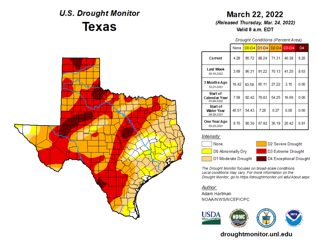
We’ll get to all the sun and sneezes in a minute. First, let’s talk drought again. This week’s rainfall came at a good time. Much of the state saw at least some rainfall from the storm. This led to about 3% of state being removed from drought (and about 25% of the Houston area being removed from drought as well).
Drought concerns were eased some across Texas, especially in the Houston area through Austin with this week’s storm. (US Drought Monitor)
We will probably need a storm a week affecting a greater part of Texas to remain with minimal drought concerns and to improve the situation elsewhere in the state. We may see one storm next week, but it looks less widespread and significant than this week’s storm as of today. No one will complain if we can keep the tornadoes away from Texas though.
Weekend
Today, tomorrow, and Sunday look great. Each day will see a little bit of warming, and it will feel solidly like spring. Look for about 80 or so today, and low 80s tomorrow and Sunday. Morning lows will generally be in the 50s both Saturday and Sunday. It will be sunny with low humidity but perhaps just enough to allow for some morning fog in spots. Winds will be light to moderate all weekend, generally about 10 to 15 mph.
Monday should just be an extension of the weekend with a good amount of sunshine. But there will be some changes. As a strong storm wraps up in the central Plains, onshore flow will begin to strengthen on Monday and Tuesday. Winds will likely jump to 15 to 20 mph, with higher gusts at times, especially along the coast.
The forecast map for Tuesday shows strengthening low pressure over Kansas and Nebraska which will help drive up onshore winds across Texas. (NOAA)
The next front will cruise through probably on Wednesday with a chance of showers and storms. At this time, it does not look to be too big a deal, but we’ll keep tabs on things. That should usher in another couple days of fair weather to close out March. Ahead of the front, look for temps in the 80s, with lows in the 60s, and noticeably more humidity than the weekend. Behind the front, we’d probably cool into the 70s with lows perhaps in the 50s.
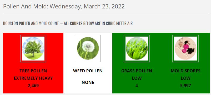
Good morning. Houston’s forecast continues to hold no concerns weather-wise, with spring-like conditions persisting as far as the eye can see. Of course springtime in Houston also means that our lawns, trees, and flower beds start to emerge from their wintertime slumber. And that means pollen. For now, the major concern comes from our trees—particularly oaks—shedding pollen. According to the City of Houston’s Health Department, tree pollen levels are “extremely heavy” at present, having risen nearly 10-fold over the last week.
(City of Houston Health Department)
This, of course, will pass after a few weeks. But until then expect to feel the effects on your allergies, or in a thin film of yellow-greenish dust on your vehicle or other surfaces outside. This is a small price to pay for summertime shade!
Thursday
Temperatures have generally fallen to about 50 degrees this morning, and we’ll see another sunny day today with highs pushing up to around 70 degrees. You probably won’t notice it too much, but a reinforcing shot of dry air should arrive this afternoon with another moderate front. This will be felt most keenly as winds shift to come from the north-northeast this afternoon. Lows tonight should drop into the 40s with drier air and clear skies.
Friday, Saturday, and Sunday
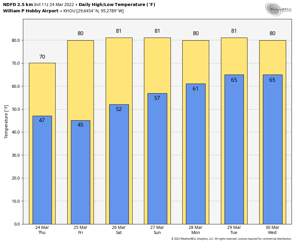
As high pressure in the wake of this second front dominates our weather, expect fair conditions through the weekend. Each day will see high temperatures of around 80 degrees, with nights mostly in the 50s. Skies will be mostly sunny, with the possible exception of Sunday, which may see a few clouds. Dewpoints will start to rise this weekend as winds turn southerly, but there will be enough dry air both days such that it won’t feel overly humid. So, yeah, this will be a great spring-time weekend.
Here come the 80s! (Weather Bell)
Next week
As the onshore flow gets going, clouds will return next week, along with some modest rain chances by later Tuesday and Wednesday. Highs will remain in the range of 80 degrees, with nights in the 60s. It looks like our next front, a relatively weak one, will arrive later on Wednesday or Thursday, likely dropping lows back into the 50s.
Welcome to a semi-regular series at Space City Weather we’re going to call “SCW Book Club.” Anyone who follows me (Matt) on Twitter knows I almost always share what I am reading with everyone. Often it has to do with Revolutionary Era history, but sometimes I actually read about stuff that is more relevant to my job. The goal of these posts is to share with you books about topics relevant or tangential to weather, specifically here in Houston. Given that I do read about other things (like the history of Ukraine at the moment), this will be an irregular series, but I will make sure to make mention of what relevant read I will be tackling at some point next, hopefully sooner than later.
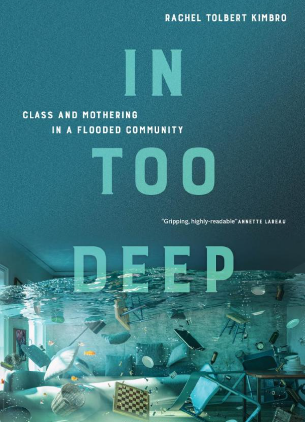
The first book I want to share with you in this series is Rachel T. Kimbro’s “In Too Deep.” Kimbro is the Dean of the School of Social Sciences at Rice University and a professor of sociology. Her recently published book, “In Too Deep” examines the experiences and decision-making processes of a group of 36 mothers in an upper-middle class neighborhood of Houston. She does not name the flood-prone neighborhood, instead calling it “Bayou Oaks, which is a pseudonym for the area in southwest Houston. If you read the book and are from Houston, it becomes fairly evident which general neighborhood is being discussed. Much of the neighborhood’s identity centers around children and the elementary school, which provides a major focus of the book.
“In Too Deep,” by Rice Dean of Sociology, Rachel T. Kimbro tells the story of Hurricane Harvey through the experiences of upper-middle class mothers in Houston. (University of California Press)
In her introduction, Dr. Kimbro argues that the disaster experiences of more affluent families are an overlooked part of disaster research, which understandably often focuses on those most vulnerable with the fewest resources to call upon. After reading her book, it makes a lot of sense to me why it was a good idea to write, beyond the story it tells. Kimbro details why these families chose to live in this particular neighborhood and why they rejected the suburbs or other neighborhoods in the city. That becomes important in understanding why most of them chose to stay, even after repetitive flooding.
She coins a phrase in the book that I find quite useful: “Flood capital.” In other words, the experiences of these families through repeated flooding, as well as their extremely deep social network in the community provides them access to resources many people in our area can’t find as easily. Some of these families were able to make arrangements for housing and repairs even before the storm hit because of the flood capital they had gained. This of course is in addition to their well-off socioeconomic standing that allows them access to many financial and recovery resources as well. As Kimbro notes, there is disaster research suggesting that those that are well-off before a disaster are often even better off after the disaster and disasters actually increase social inequality. Her research will add to the understanding of how that could be.
The bulk of the story really does focus on the mothers though. They generally raise their families using the principal of “intensive mothering,” which is basically child-centered, expert-guided, labor intensive, and expensive. The book delves into how this parenting technique is practiced specific to these families. You’ll also learn how within these families, there is a large difference between how the fathers and mothers viewed the risks from Harvey, as well as how they managed the recovery. I will just say that the mothers of this story handled the majority of the labor involved in both the preparation and recovery, and they have been through an awful lot.
This topic is not one that’s easy to discuss, and it’s one that is uncomfortable at times. But the story is critical to understanding the Harvey experience, disasters, why buyouts won’t appeal to everyone, and why some people fare so much better than others. This should help shape how community leaders can help less well-off residents improve their reactions and response to disasters. Additionally, it shines a light on why people stay in places they know are disaster-prone, which can offer food for thought for community planning in the future.
Kimbro’s writing is really clear and understandable, and the book makes for a pretty brisk read. She seamlessly weaves in the sociology with first-hand accounts from the mothers she interviewed, and it makes for an informative story — but still a story. This book has valuable academic results, but it does not read as an academic book, which should allow it to appeal to a broader audience. I thought it was excellent, and I would encourage you to consider also giving it a read.
A quick warning: The book does discuss the actual flooding, damage, and impacts, so for some of you, it may trigger unpleasant memories. While still very informative, if you were deeply impacted by Harvey it will be an uncomfortable read at times.
Good morning. Before the forecast, let me just say a few words about Tuesday’s storms. Most of the tornadoes associated with this powerful system remained well to the west (Austin), north (Crockett), and east of the Houston metro area. Notably, a powerful tornado struck the New Orleans area on Tuesday night, killing at least one person, and damaging many homes. Such large tornadoes are relatively rare in cities near the Gulf coast, a category which includes Houston. Why? Because the supercells that produce them typically form and pass further inland. This is due to the sharp temperature gradients needed between warmer and cooler air to produce tornadic rotation, which are often not present so close to the Gulf of Mexico. Usually, but not always, the tornadoes we see in Houston are EF-0 to EF-1, with winds of about 60 to 100 mph. An assessment will be performed today to determine the strength of the New Orleans twister.
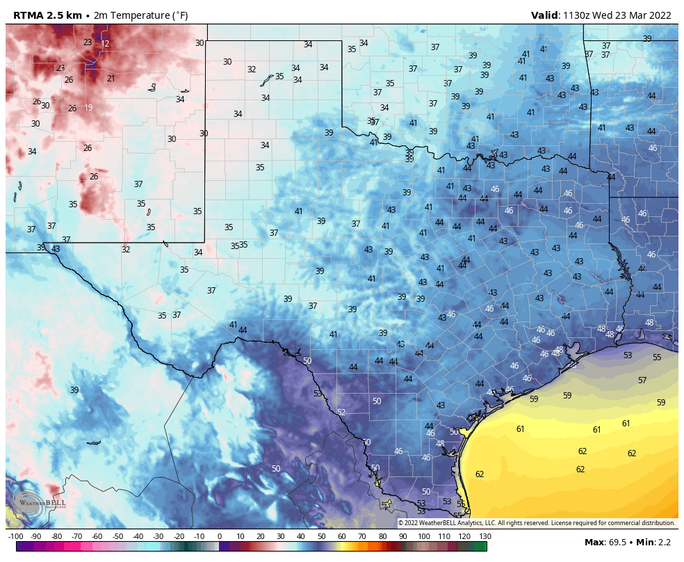
There won’t be too many mornings this cold again across Texas, this spring. (Weather Bell)
Wednesday
Temperatures have generally fallen into the upper 40s across the metro area and winds have died down this morning. With high pressure holding sway we’ll see some gorgeous spring weather this week. I call this “almost painful” weather because living in Houston we know the kind of heat and humidity that is coming this summer, and it’s almost painful to think about how pleasant things are now in contrast. But that’s my opinion of course, I know some of my readers absolutely love summers in Houston. To that I say, bless your hearts. High temperatures will reach near 70 degrees today, with winds out of the north at 10 to 15 mph. Low temperatures tonight will be similar, in the upper 40s for most.
Thursday and Friday
We’ll warm up heading toward the end of the work week, with highs in the low 70s on Thursday, and near 80 degrees by Friday. Lows should still drop into the 50s.
Saturday and Sunday
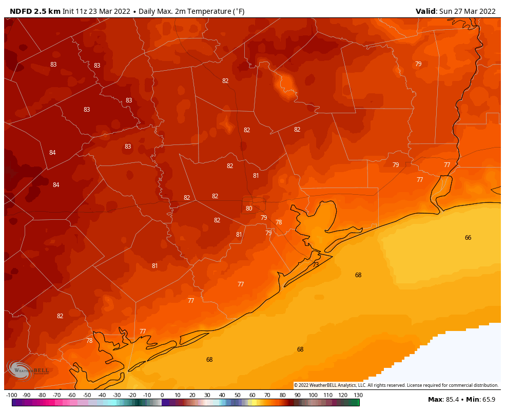
The onshore flow resumes this weekend, but we still should see fairly dry air and mostly sunny skies. In short, it should be another great weekend for whatever springtime activities you have in mind. Both days should see high temperatures of around 80 degrees, give or take. There are no rainfall concerns.
By Sunday highs should rise to the low 80s for much of the region. (Weather Bell)
Next week
Clouds return to the forecast for the first half of next week, but for now I’m not anticipating much in the way of rainfall. Dewpoints will continue to rise, however, so we’ll become friendly with humidity by Monday or Tuesday. The next front should arrive later on Wednesday or next Thursday, but we’ve now reached the point of the forecast where it should be written in pencil, so we’ll just have to see what this way comes.