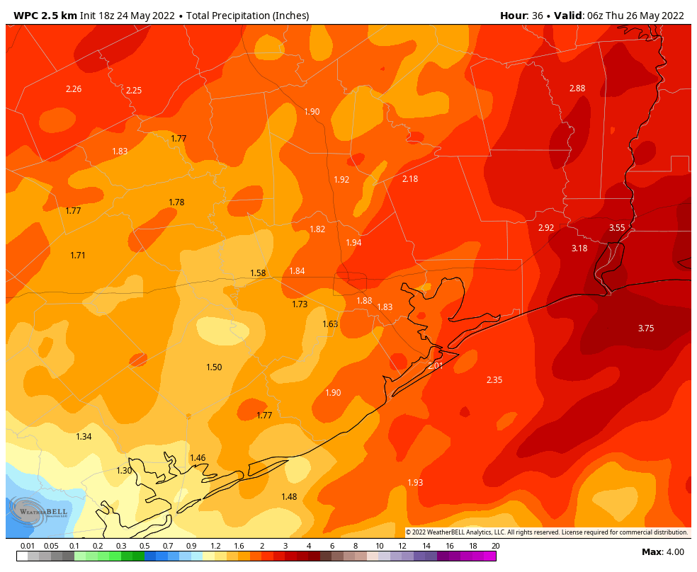
Just wanted to provide a quick update on an approaching cold front that will push a line of thunderstorms, some of them severe, into the Houston metro area early on Wednesday morning. The main threats will be damaging wind gusts as well as heavy rainfall. In terms of timing, the line of storms should reach the College Station area shortly after midnight, push into the central Houston region around 4 am, and be off the coast by about 6 am.
Matt and I discussed issuing a Stage 1 flood alert for this storm, but ultimately we decided not to. First of all, the storms look to keep moving along at a good clip as they push through the region. So while rains may be intense, accumulations probably won’t be above 1 or 2 inches for most locations. (Some isolated areas, of course, will probably see more). And given the timing of these storms, they should affect the bulk of the metro area before sunrise. So as the morning commute gets going on Wednesday, the worst should be over for Houston. For areas further east, such as Beaumont-Port Arthur, the timing is such that the storms will be hitting around 6 to 8 am.
NOAA rain accumulation forecast for now through Wednesday. (Weather Bell)
It’s always possible that these rains come in heavier than we’ve forecasted above, but for now I think accumulations will be manageable, and certainly our soils need these rains. Some additional scattered showers will be possible later on Wednesday afternoon, but I think overall chances are low, especially after a much drier air mass moves into the region during the late afternoon and evening hours. Thursday morning should be absolutely spectacular.
Good morning. The main event for our near-term weather is the arrival of a cold front late tonight that will bring a line of storms through our area early Wednesday, likely reaching the metro area shortly before sunrise. This front will usher in some briefly drier air, with Thursday looking especially spring-like with morning lows possibly in the low 60s. Memorial Day weekend looks warm and sunny.
Tuesday
Yesterday I talked about the potential for an upper-level system to bring some showers and thunderstorms into the metro area on Tuesday morning, but noted that all of the ingredients might not come together for the showers to hit Houston. Well, they haven’t, and the bulk of the rain will remain offshore today. Accordingly rain chances are only about 50 percent today, and any scattered showers that move through should do so fairly quickly from southwest to northeast. Otherwise, expect mostly cloudy skies today with highs in the mid-80s. Winds may gust as high as 20 mph out of the south.
Tuesday night and Wednesday
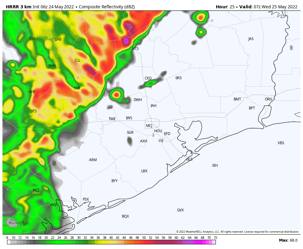
I’m more confident in the arrival of a cold front tonight, likely reaching the College Station and Conroe areas around midnight, pushing into central Houston around 2 to 4 am CT, and off the coast by sunrise. A line of storms will accompany the front, bringing thunderstorms, straight-line winds, hail, and even the potential for a tornado or two.
HRRR model depiction of a line of storms approaching Houston at 2 am CT on Wednesday. (Weather Bell)
I expect that some of these thunderstorms will bring heavy rainfall, and overall accumulations will probably range from 1 to 3 inches for most of the metro region, with higher isolated totals. While the bulk of the rainfall should have passed by around sunrise on Wednesday, some light to moderate showers may linger into the late morning hours. High temperatures on Wednesday should top out in the upper 70s as skies probably won’t start to clear until Wednesday evening.
Thursday
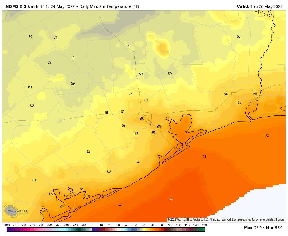
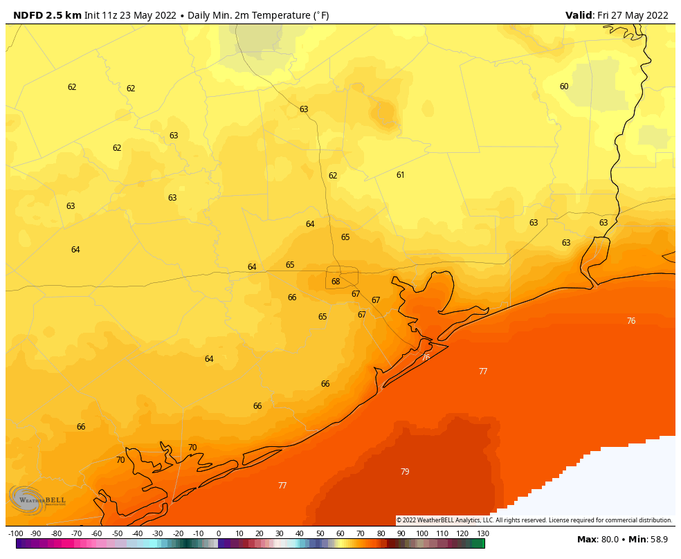
This is going to be a pretty amazing spring-like day in Houston, especially for late May. Lows will start out at 60 to 65 degrees, and despite sunny skies we’re going to see temperatures likely top out in the mid-80s. With dewpoints in the low 60s, the air will also feel reasonably dry. The evening should be pretty great as well, with some drier air holding on and temperatures dropping. Lows on Thursday night should eventually fall into the mid-60s.
Low temperatures on Thursday morning will be pretty incredible. (Weather Bell)
Friday
This will be a transition day back to more summer-like weather, but there still should be a smidge of drier air, with highs in the upper 80s, sunny skies, and overnight lows dropping to around 70 degrees.
Memorial Day Weekend
The forecast over the weekend will bring three days of sunny skies, highs around 90 degrees, and lows in the 70s. It will be plenty humid outside, but not boiling hot as this holiday weekend can sometimes be. Conditions should be perfect for outdoor activities, although please be sure and protect yourself during prolonged exposure to the sun.
Next week we’ll be monitoring the potential for a tropical disturbance to form in the Bay of Campeche, in the far southern Gulf of Mexico. This may eventually bring some moderate rainfall our way next week, but right now it’s not something to be concerned about at all.
After a summer-like pattern took hold of our region for nearly all of the Month of May, change came early on Sunday morning with the arrival of a front and a good soaking. To give you an idea of how abnormal our weather was in May, consider this statistic from the National Weather Service about Galveston’s heat. Sunday’s low temperature in Galveston was 72 degrees, by far the lowest of the month. Before Sunday, the monthly average low was 78.6 degrees, which smashed the previous highest average for the May 1 to 21 period. Previously, 2003 had the warmest average low temperature, 75.4 degrees during the first three weeks of May. Galveston’s weather records date to 1875, so that’s nearly 150 years of data. This type of warmer weather is consistent with what we would expect to see due to climate change.
Fortunately, the rest of the month should be much more temperate.
Monday
In the wake of Sunday’s front, temperatures today should generally reach the upper 80s beneath mostly sunny skies this afternoon. Rain chances are less than 10 percent, and winds will be moderate, out of the north at 5 to 10 mph. Lows tonight will drop into the low-70s for most locations. In other words, conditions will be pretty darn nice for late May.
HRRR model forecast for radar reflectivity at 5 am Tuesday. Subject to major changes! (Weather Bell)
Tuesday
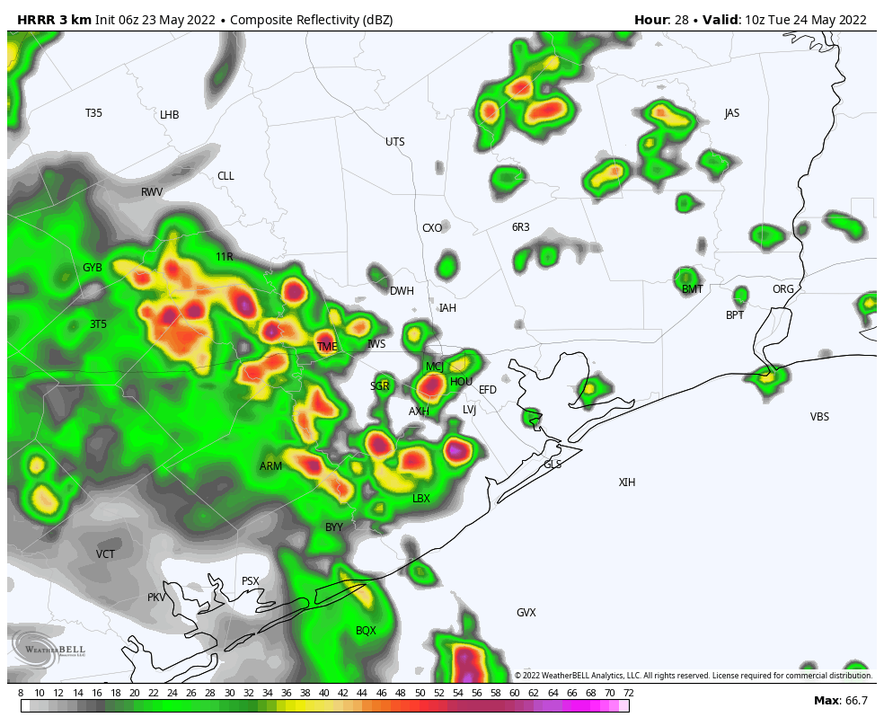
There is the potential for heavy rain on Tuesday as an upper-level system moves through, but I’m not certain all of the ingredients are going to come together. We’ll be watching for a line of storms to develop in central Texas late on Monday night, and then move through our area from southwest to northeast. The timing is a bit uncertain, so these storms could reach us by around sunrise or a bit later. If the storms come later, they probably will be stronger, as they would benefit from daytime heating. Otherwise, skies should be mostly cloudy on Tuesday, with highs in the mid-80s. Rain chances will drop off during the evening and overnight hours.
Wednesday
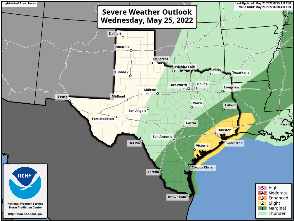
Yet another “cold” front is on track to push through the region on Wednesday. In terms of timing, we’re probably looking at a passage during the afternoon hours through Houston, and again there will be the potential for some heavy rainfall as this system moves through, this time from north to south. Some of these storms could be severe, so most of the Houston area faces a “slight” chance of severe weather, according to NOAA.
Severe weather outlook for Wednesday. (NOAA)
Total rainfall amounts through Wednesday should vary widely, with accumulations generally of 1 to 3 inches, with the potential for higher localized amounts. Honest-to-goodness drier air should work its way in behind the front, ending showers and thunderstorms by Wednesday evening. Daytime highs should be in the 80s, with lows dropping into the 60s overnight.
Thursday and Friday
These should be splendid, late-spring days with highs in the mid- to upper-80s, sunny skies, and slightly drier air. Lows on Thursday night should drop into the mid-60s for much of the region, while Friday evening will be a touch warmer. My pick of the week will be Thursday evening, when I expect very pleasant conditions out of doors. Enjoy this spring fling!
Low temperature forecast for Friday morning. (Weather Bell)
Memorial Day Weekend
The holiday weekend will see warmer weather with mostly sunny skies. Highs through Monday should be around 90 degrees, or in the low 90s at the warmest. Dewpoints will be rising, but not to oppressive levels. Rain chances look to be near zero until Tuesday or Wednesday of next week.
Hi all. Just a short weekend update to note the potential for some reasonably strong thunderstorms late tonight as a cold front pushes into the region. Today will be hot and mostly sunny, with highs in the low- to mid-90s. Winds will be gusty out of the south, so it will be pretty much business as usual in terms of our recent weather. But conditions will begin to change tonight with a significant pattern change.
Saturday night
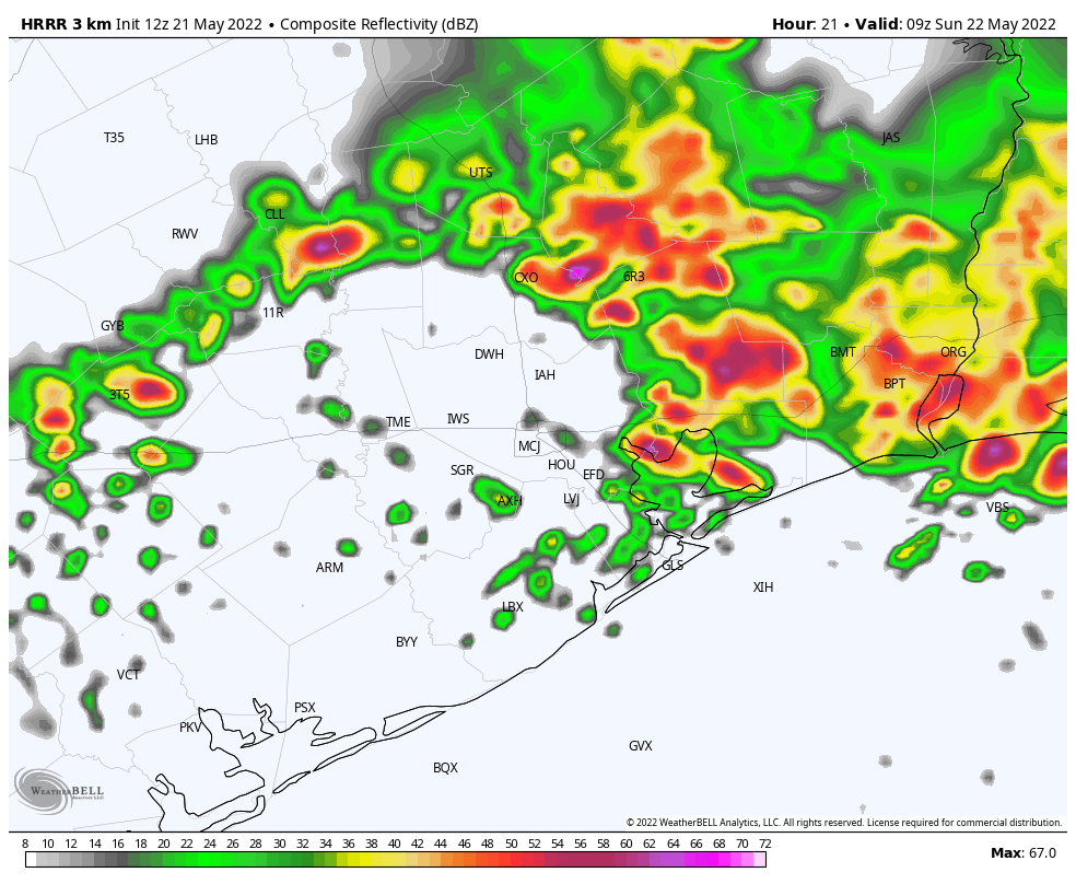
It looks like a (probably broken) line of storms will reach College Station around midnight, and then trudge down toward the coast by around sunrise. Probably the major threat is briefly strong straight-line winds, with the secondary potential for small hail. In terms of rainfall, accumulations will probably vary from a sprinkling to 1 inch or more of rain, with greater accumulations likely along and north of Interstate 10.
HRRR model radar reflectivity for 4 am CT on Sunday. (Weather Bell)
Sunday
There may be a lull in shower activity on Sunday morning before the potential for some on-and-off showers returns on Sunday afternoon. Highs should reach the mid- to upper-80s. Rain chances will fall back Sunday night.
Next week
A healthy chance of rain returns Monday night and then may stay with us through Wednesday night as a series of disturbances moves through, culminating in a slightly stronger cold front on Wednesday night or some time Thursday. Rain accumulations for most should be 2 to 4 inches for now through next Thursday, which is welcome. And if we end up with a night or two in the 60s late next week, that will just be a huge bonus.
We’ll have a full post up Monday morning, as usual.