Sweltering again today, as July remains on track to be the warmest on record for Houston

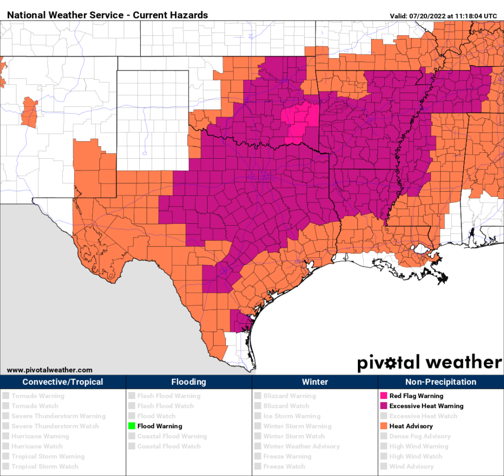
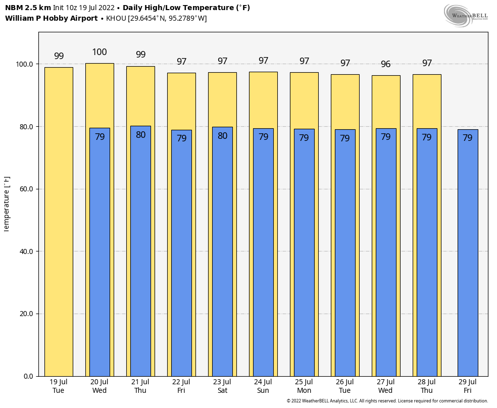
Good morning. The month of July is now two-thirds over, and if the month ended today Houston’s average temperature of 88.6 degrees would rank as the warmest July on record by nearly a full degree. I’m now confident we’ll set this record for July.

Alas, there is not much good news I can offer today except this: We’re now reaching the historically warmest part of the summer—from about July 20 to August 20. Why is this good news? For the optimist in me, this means we can at least begin to dream of fall.

Wednesday’s high temperatures were sweltering across the entirety of the state of Texas. (Weather Bell)

Thursday

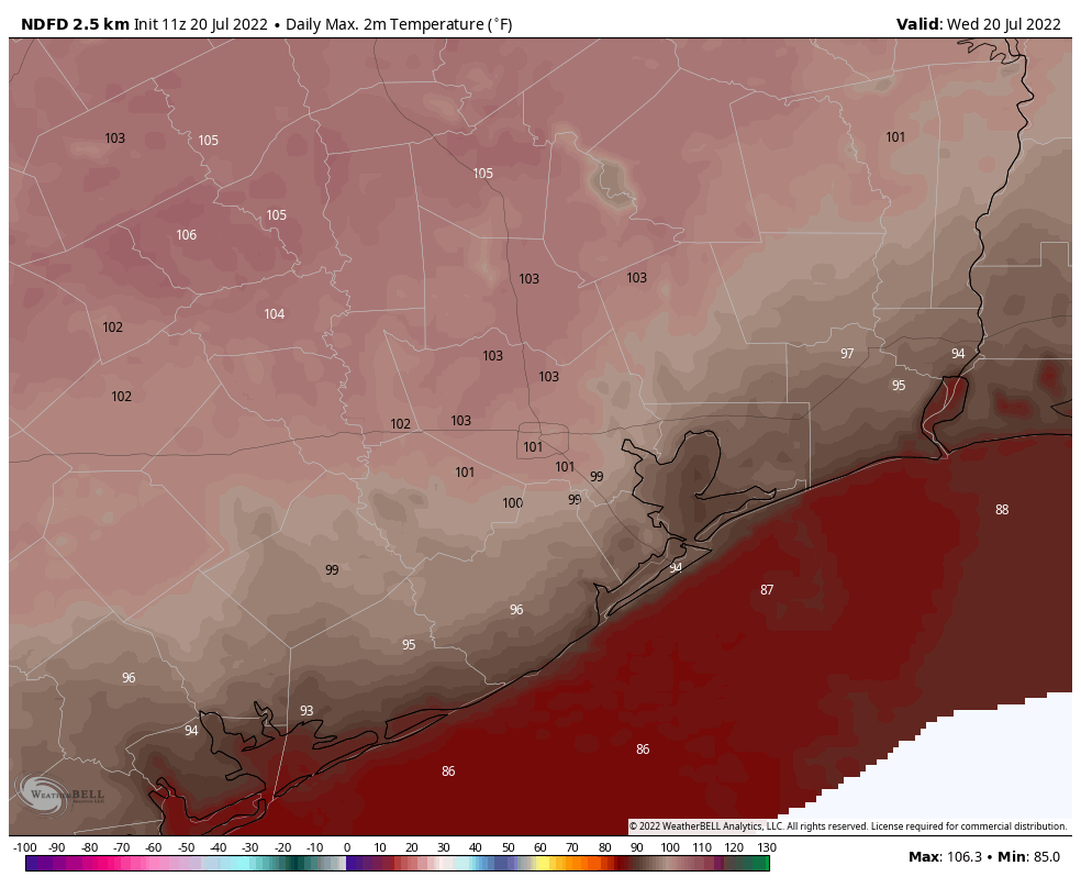
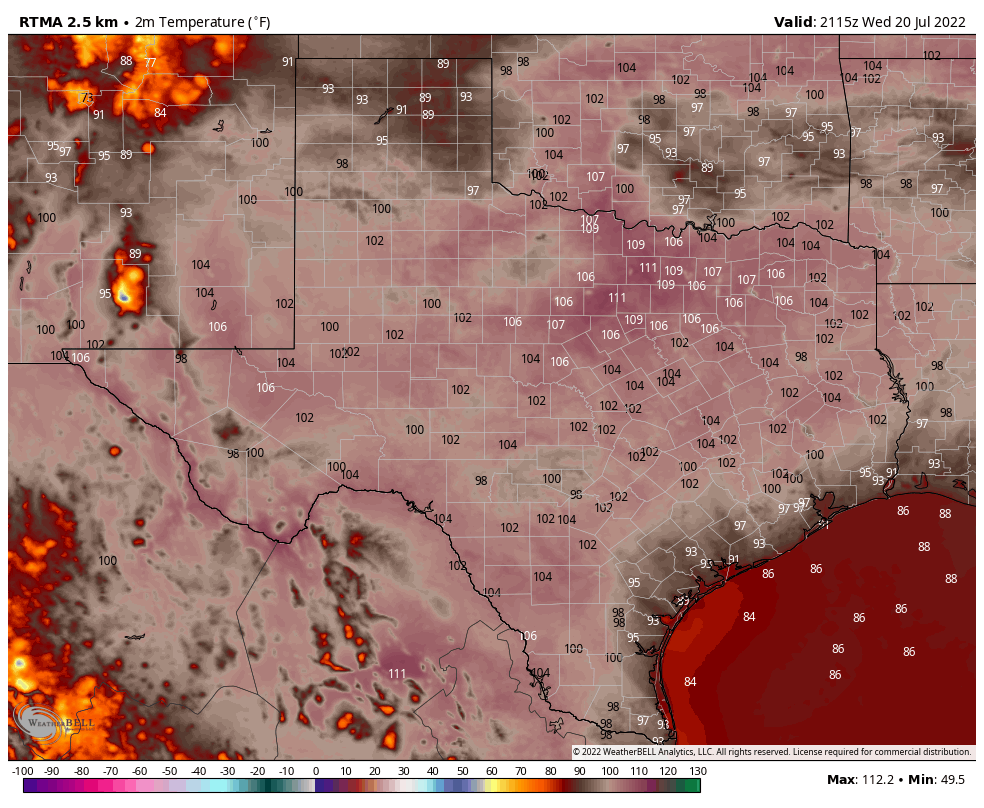
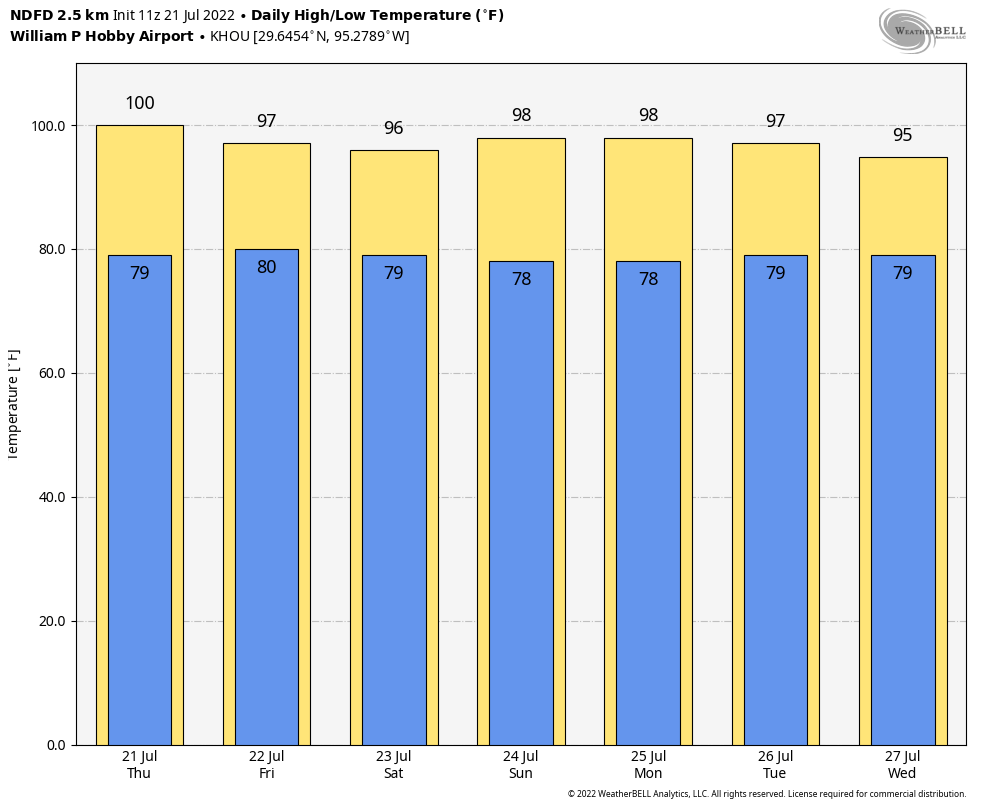
With high pressure more or less overhead we’re going to see another sweltering day, similar to Wednesday. Expect highs in the low 100s for inland locations, and upper 90s along the coast. Skies will be mostly sunny, with a less than 10 percent chance of rain. Winds will be out of the south at 5 to 10 mph.

Friday

As the high starts to back off slightly, a disturbance may approach the area from the east on Friday. This will have modest effect on temperatures, perhaps limiting highs to the upper 90s. It will also produce a 20 to 30 percent chance of rain from a passing shower. Good luck!

Saturday and Sunday

The weekend is going to be hot, with mostly sunny skies and highs in the upper 90s to 100 degrees for most of the area. Rain chances are probably in the 10 to 20 percent range for coastal areas, with lesser chances further inland.

Our moderation in temperatures will be slight next week, but should at least go in the right direction. (Weather Bell)

Next week

As we get deeper into next week I’m still anticipating a slight moderation in temperatures as the high pressure system slowly moves eastward. I expect much of the region to see highs in the mid- to upper-90s, with a slight 20 to 30 percent chance of afternoon showers or thunderstorms. It won’t be much relief, but it will beat what we’ve been experiencing.

Excessive heat warnings are back for inland parts of the Houston region

Houston will see peak heating the next couple of days—with nearly all of the region experiencing triple digit temperatures away from the immediate coast—before a dominant high pressure system starts to progress eastward. This should slowly start a return to somewhat more normal weather, which is to say by the middle of next week we could be in the mid-90s, with decent rain chances.

An excessive heat warning is in effect for inland areas. The remainder of the Houston region falls under a regular heat advisory. (Pivotal Weather)

Wednesday

An excessive heat warning is in effect for inland counties today, including the cities of Crockett, Madisonville, Huntsville, Caldwell, College Station, Bryan, Brenham, and Navasota. This means these areas could see high temperatures of 105 degrees or above, with dangerous heat levels due to humidity. The rest of the region should see highs of around 100 degrees, or a bit higher, with only the coast remaining in the 90s. Skies will be sunny, with southerly winds at 5 to 10 mph, and higher gusts. Lows tonight will not drop below 80 degrees.

Thursday

Another brutally hot day, similar to Wednesday.

Wednesday is going to be exceptionally hot. Thursday will be similar. (Weather Bell)

Friday

By Friday the high pressure system should start to back off a little bit, and this should open up the potential for a few isolated to scattered coastal showers. However, I don’t expect these rains to make it past Interstate 10. Most of the region should otherwise see mostly sunny skies, with highs in the upper 90s.

Saturday and Sunday

The weekend should bring highs in the upper-90s for much of the region, with mostly sunny skies and only slight 10 to 20 percent rain chances.

Next week

After starting in the upper 90s, temperatures will be slow to come down next week. But by Wednesday or Thursday we could start to drop back toward the mid-90s, and with a few more clouds begin to see the more widespread development of showers and thunderstorms. For now I’d guess rain chances most days will be in the 30 percent range, but there’s just no way to tell with much precision at this point. The bottom line is that the next six or seven days look pretty dry, in terms of rainfall, but there is least some potential for change after that point.

Eye on the Tropics: July Lull Part II

No one complained to us that we skipped last week’s tropics post. Hopefully no one complains that this week’s is rather short!

Tropical outlook in a sentence

There are no signs of any organized systems in the Atlantic Basin over the next week to ten days, but we do expect our slumber to gradually end come August.

2022 as of today: Does the quiet start mean anything?

Much like last July, this July has been quite quiet. We managed to get Colin briefly back on July 2-3, and since then there’s been nothing. Last year we had made it to E by now. In 2020, we were on F. We remain at 2.8 accumulated cyclone energy units to date. The normal is just over 6 by this point. For the season, we typically see above 120, so we have a long, long road ahead.

While accumulated cyclone energy (ACE) is below average now, average is pretty low. We have another 2 to 3 weeks before the big ramp into peak season. (Colorado State University)

Just to refresh: ACE is an equation that tallies how long a storm maintains an intensity. It’s then accumulated, storm by storm, over the course of the season. Most recent seasons have been active to very active. While it’s nice that 2022 is beginning below average, it’s also not exactly meaningful. From an ACE point of view, 95 percent of the season is yet to come. The big ramp in activity typically begins around August 15th, so we’re 2 to 3 weeks away from normally having a bit more to discuss.

What’s happening now?

When I say not much is happening in the tropics, I really do mean that. It’s very, very quiet. We’ll occasionally get a robust wave off Africa, but it typically either runs into significant dry air and dust or wind shear and dissipates.

Saharan dust has impacted Houston lately, and there’s an awful lot of it (yellow, orange, red, pink) in the Atlantic Ocean. So dust season isn’t over yet. (University of Wisconsin SSEC)

While we’ve had some Saharan dust over Houston lately, we may see more next week. There’s a lot of dust out there, so we just need a brief window to open to sneak some more of that into the Gulf.

In addition, wind shear in the Caribbean is strong and projected to stay that way over the next week or so. Anything trying to get here will struggle. And our recent spate of hot weather is basically being caused by high pressure sealing Texas off from any Gulf mischief. The longer that continues, the worse the drought but the less risk of hurricanes. Mostly.

We see no real meaningful sign of change for the time being, so let’s continue to enjoy the calm, and use this time to ensure we’re prepared in case things do change later in August or September.

Super hot and dry this week, but perhaps there will be a slight moderation next week

Good morning. There’s not much good to say about our weather for the next several days, outside of the fact that at least we won’t see flooding or the winds howling. However, after three or four really hot days of triple-digit temperatures, I do think we’ll see a slight downturn in highs, and an uptick in rain chances. The effect is likely to be subtle, but any relief is better than no relief, right?

Tuesday

Monday’s high temperature reached 100 degrees at Bush Intercontinental Airport, and we can probably expect today to be a carbon copy with mostly sunny skies. Winds will be out of the south, at 10 mph or so, with gusts up to 15 or 20 mph. Lows tonight probably won’t drop below 80 degrees for most of the region.

Tuesday’s high temperature forecast. (Weather Bell)

Wednesday and Thursday

It looks like the heat will peak on these days, with highs ranging from 100 to the low 100s for much of the area away from the coast. Expect sunny skies and southern winds. You should know the drill by now.

Friday, Saturday, and Sunday

It’s still going to be hot, but highs at some point should start to drop back into the upper 90s. We’ll also see a somewhat more disturbed atmosphere that should allow for the development of at least some isolated showers and thunderstorms. Expect mostly sunny skies.

Slight relief is better than no relief, right? (Weather Bell)

Next week

Overall, the pattern won’t change a whole lot. But I think we’ll see highs in the mid- to upper-90s, instead of around 100 degrees. And rain chances will continue to be non-zero, but at this point it’s difficult to say whether we’re talking about 10 to 20 percent chances each day, or the more hopeful 30 to 40 percent.