Texas now entering a new weather pattern for most of the rest of August

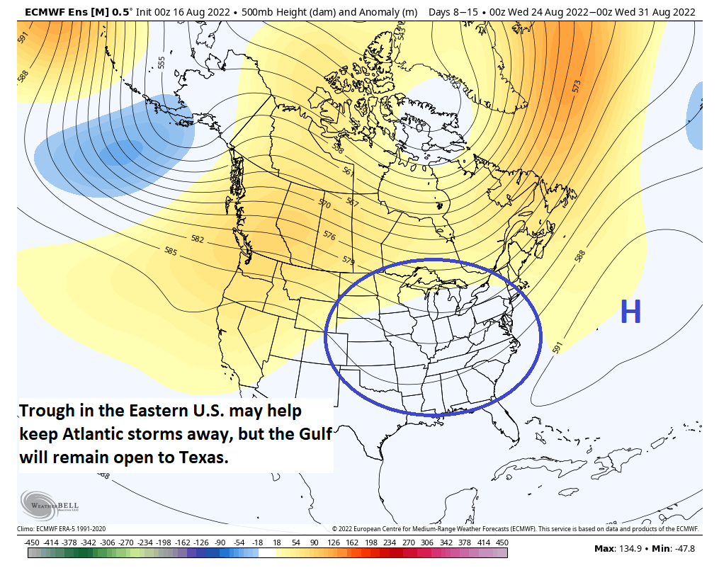
As Eric has been alluding to all week, things have now changed, and they will continue to do so in a big way for not just Houston but all of Texas. Last evening’s rowdy (and in some cases damaging) storms were the first phase in what will be a much different weather pattern for the rest of the month. The Texas-wide drought is on notice for what should be significant relief.

Today

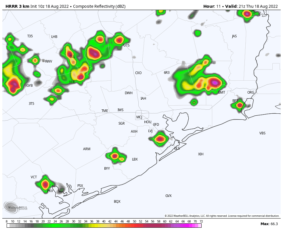
We’re starting the morning off with some noisy storms south of Houston. The storms are generally moving east, but the overall trend seems to be to build storms back to the north some. None are severe at this point, but there are some special marine warnings on the coast due to 35 to 45 mph wind gusts, or a bit stronger, as well as the potential for waterspouts.

Radar as of 7:30 this morning shows numerous showers and storms, with locally heavy rain mainly south of Houston, but trying to gradually build north. Click to enlarge. (RadarScope)

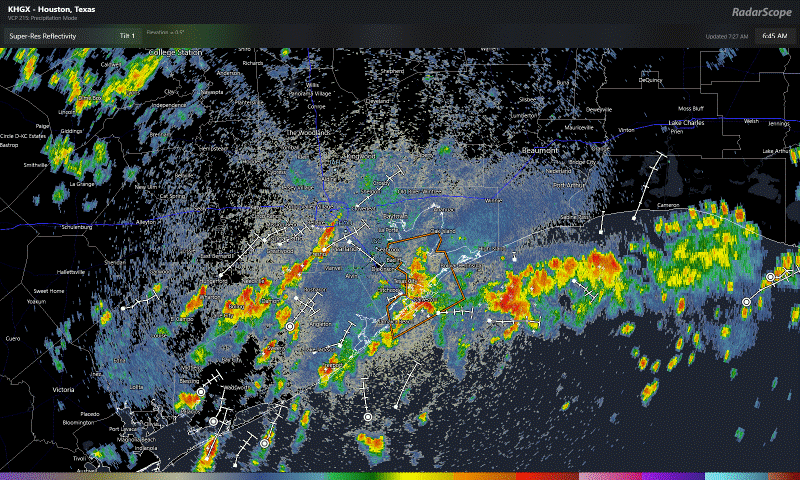
As the day goes on, storms should continue expanding northward and inland. Locally heavy rain is again possible today. Thus far, rates are fairly manageable, but a few spots may need to be watched today for some street flooding. Most of Southeast Texas has been outlined in a marginal (Level 2/4) risk for flash flooding today. As a precaution, we are going to issue a Stage 1 Flood Alert, based on the SCW Flood Scale.

Street flooding is possible anywhere in the area today, but I would watch areas west of Houston that saw 2 to 3 inches of rain yesterday, as well as areas south of Houston, where the heaviest rain is right now. Yes, this is welcome rain to be sure, but some nuisance street flooding feels possible today, especially through early afternoon.

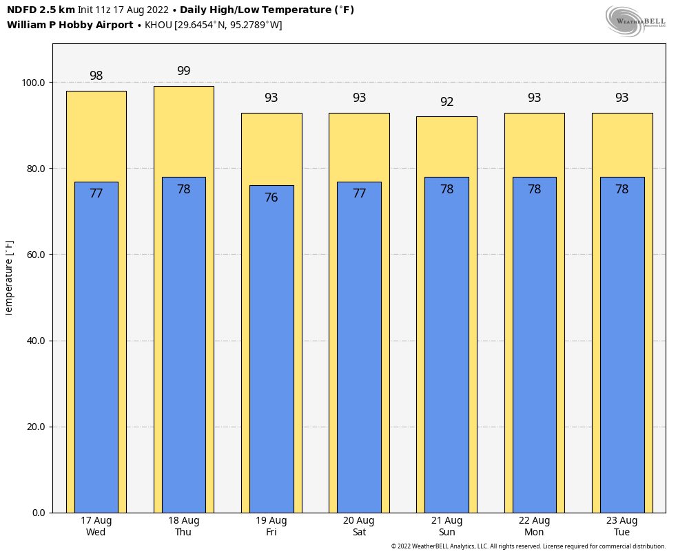
Storms should calm down by evening. Clouds and showers will keep temperatures down today. Highs should only be in the 80s, though if you see sunshine in your location, you could pop above 90, especially north and west of Houston.

Invest 99L & weekend

The weekend forecast will be hit and miss for most folks. At this point, I think both Saturday and Sunday carry a good chance of at least scattered showers or storms, near the coast in the morning, expanding inland during the afternoon. Locally heavy rain is possible, but widespread heavy rain seems unlikely this weekend. Both days should see some sunshine, which will allow us to punch back into the 90s in most spots, with morning lows in the 70s.

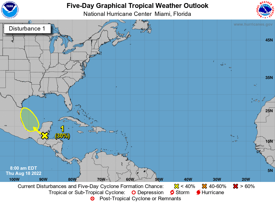
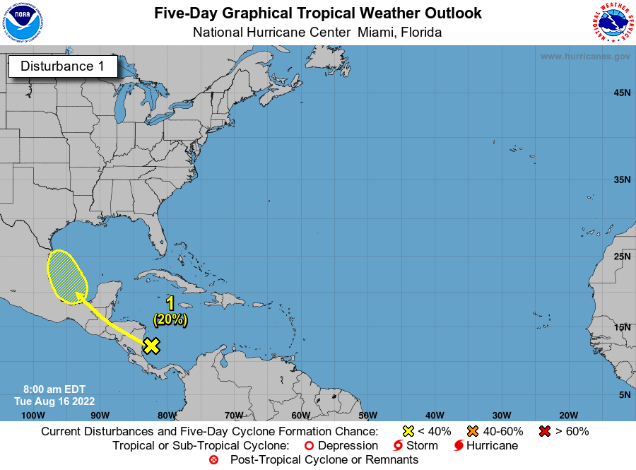
Regarding the tropics, the National Hurricane Center continues to highlight the potential for now-classified Invest 99L to become a tropical depression or storm over the next 24 hours before moving inland over Mexico on Saturday.

The National Hurricane Center says Invest 99L has a 40% chance of becoming a depression or tropical storm before moving ashore in northern Mexico tomorrow and Sunday. (NOAA/Space City Weather)

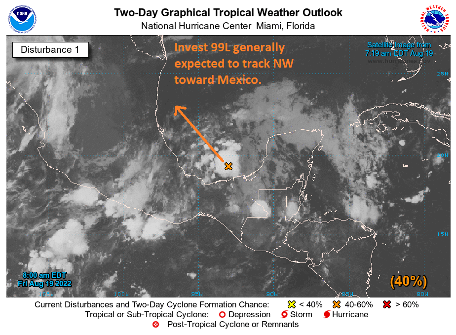
This should have no direct impact on our weather in the Houston area, but it’s possible that some heavier rains get close to South Texas later in the weekend or early next week.

Next week

I am not going to even try to pin down the specifics of any day next week. What we know is that there will be rain chances every day. Some of the rain could be heavy. Parts of the state are going to see a lot of rain (see below), probably to the north or northwest of the Houston area. Daytime highs will flirt with 90 every day, but days that see more widespread showers or storms will probably stay in the 80s. Humidity will stay high, so nighttime lows well into the 70s are still likely.
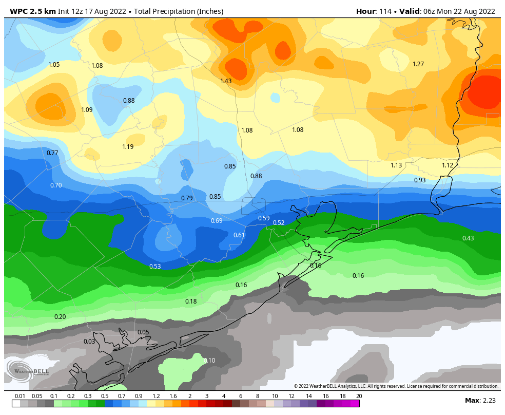
Rain totals

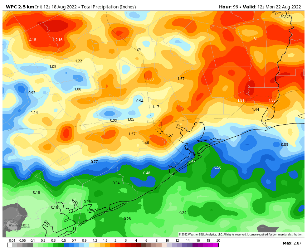
So just how much rain will Texas see over the next week or so? The answer is a lot. The current NWS outlook for rainfall across Texas is below and shows as much as 7 to 8 inches in interior Texas, including the DFW area and possibly the Austin and San Antonio areas as well. Higher amounts are possible, as is flooding across the state.

About 4 to 8 inches of needed rainfall is expected across Central Texas over the next week, with lesser but meaningful amounts elsewhere. This is a drought-easer. (Pivotal Weather)

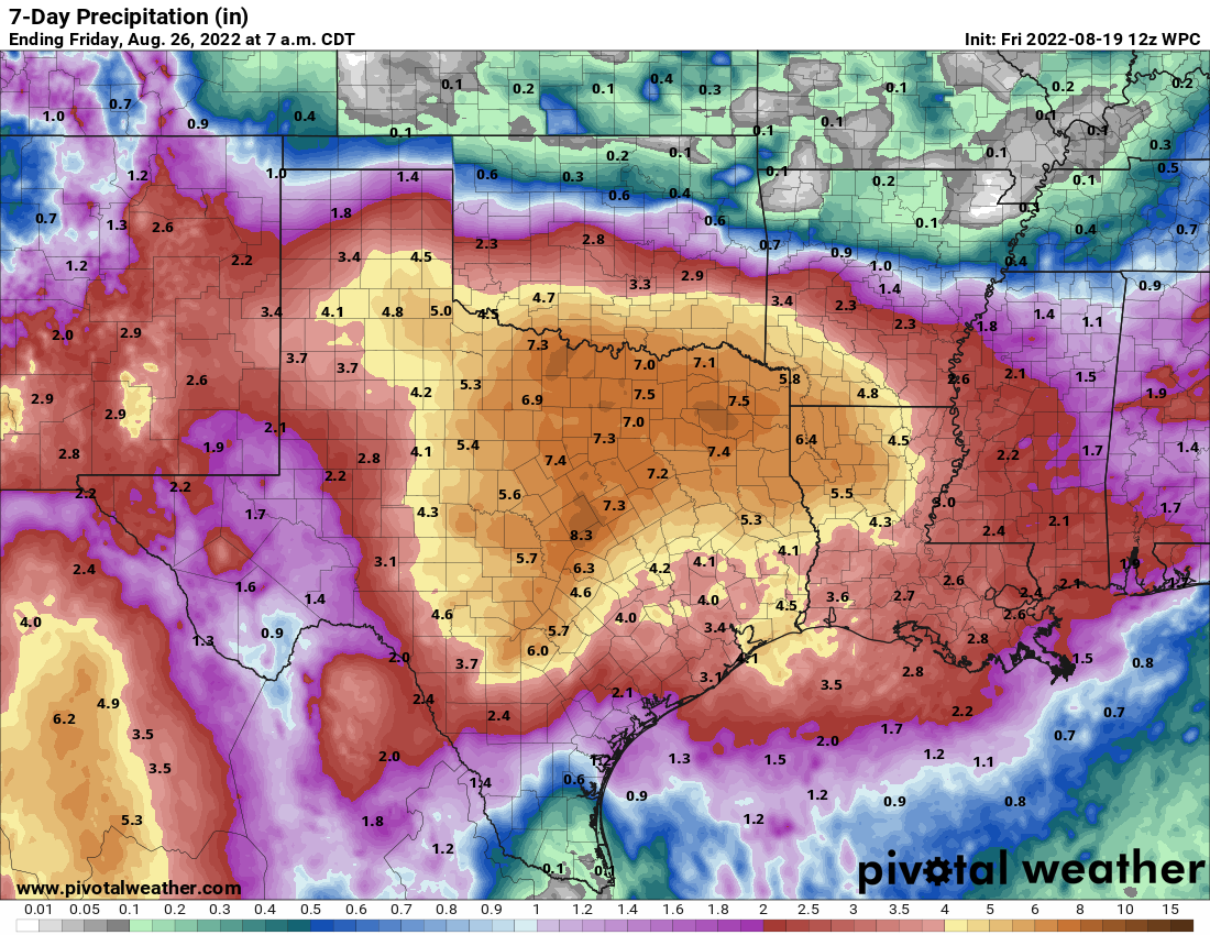
While the Houston area should see a bit less than other parts of the state, there’s still enough uncertainty in the forecast to think we have a chance at higher amounts, especially north and west of the city. Whatever the specifics, this is a big, big drought denter for the entire state of Texas. We’ll keep you posted as needed over the next few days.

Storms are possible this evening as Houston enters a cooler, more unsettled period of weather

Good morning. It has been a long, hot—so very, very hot—summer in Houston. June and July were the warmest on record for the city, and so far August has run slightly above normal. But that’s now about to change. The arrival of a weak front later today will kick off a significant pattern change that will bring temperatures generally in the low 90s, with a decent chance of rain, for at least the next week. I would go so far as to say that, after today, it is possible if not probable that the metro area may not record another 100-degree day in 2022. The rest of August really does look quite reasonable, and then we’ll have to see about September.

The high-resolution HRRR model suggests rainfall activity will start to pick up at 4 pm CT on Thursday. (Weather Bell)

Thursday

The watchword for today is uncertainty. We have boundaries between air masses all over the place, plenty of atmospheric moisture to work with, and a weak front that will be advancing southward later today. We can’t have complete confidence in the specifics about how this will play out, but here’s what we can say more generally about the forecast. Today will be another hot one, with much of the region at least reaching the upper 90s this afternoon. I think the radar will remain pretty quiet until 2 or 3 pm, after which time we should start to see showers and thunderstorms blossoming across the region. The preferred area will be north of Interstate 10, but areas closer to the coast probably won’t miss out entirely. Storms should become more widespread late this afternoon and evening, before weakening overnight.

What should your expectations be? As is usual with thunderstorms, there probably will be plenty of lightning, and some stronger winds in the stronger thunderstorms. Much of the region will pick up 0.25 to 2 inches of rain through tonight, although lower accumulations are possible right along the coast. Street flooding is possible within the stronger thunderstorms.

Friday

Rain chances Friday will depend to some extent on what happens Thursday, but a healthy chance of showers remains. I don’t think storms will match the intensity of Thursday’s, but we’ll have to see. Look for highs in the low 90s with partly sunny skies for much of the area. If you were expecting the front to bring cooler nighttime temperatures, you should temper your expectations. We’re not going to see much of a change in humidity or lows. It’s mid-August, y’all, and summertime fronts just don’t pack that kind of punch this far south.

NOAA rain accumulation forecast for now through Sunday. (Weather Bell)

Saturday and Sunday

Expect more of the same for this weekend, with partly sunny skies and high temperatures in the low 90s. Rain chances each day will be about 50 percent, but for the most part these should be showers that pass through fairly quickly (see caveat, in the Tropics section below).

Next week

Every time we’ve seen a bit of a reprieve this summer from deep heat, high pressure has pretty quickly built back over the region. However, we don’t expect that to happen this time. Instead, the upper Texas coast will fall between a ridge to our west, and low pressure to our east. As a result we should see a string of partly to mostly cloudy days with highs in the vicinity of 90 degrees. Each day should have a healthy chance of rain in the 30 to 50 percent range, but it’s way too early to have much confidence in any details. This pattern should hold for awhile. Pretty great for late August, right?

Tropical outlook for Thursday morning. (National Hurricane Center)

Tropics

The National Hurricane Center continues to track the possibility of a tropical disturbance forming in the Southern Gulf of Mexico over the next several days. Chances remain fairly low for this system to become a tropical depression or storm. As for local effects, this disturbance could increase our region’s rain chances on Sunday and Monday, but it’s just too early to tell. For now, I’m leaning toward the idea that it won’t have much of an impact.

Dare we say it? The second half of August in Houston should be reasonably nice

Good morning. Houston faces two more hot days before a weak front arrives to provide some relief, mostly in the form of cloudier skies, which will bring down temperatures, as well as producing scattered to widespread showers. After Thursday we should be done with high temperatures in the triple digits for awhile, which sounds great to me.

If we may, Matt and I would also like to take a moment this morning to thank all of the teachers in the greater Houston area. Kids have, or soon will, return to schools across the region and I know teachers have already been hard at work preparing for classes. You all have difficult jobs, particularly in dealing with parents and administrators, and we certainly appreciate your efforts to teach our children. We’re only sorry that we couldn’t give you better weather this summer.

Wednesday

Today’s going to be hot as the region bakes beneath a ridge of high pressure. Expect highs to range from the upper 90s to low 100s, with sunny skies. Some scattered showers are possible for northern areas, such as Montgomery County, but the rest of us will be dry. Winds will be light, out of the southwest, at around 5 mph. Skies will be partly cloudy overnight, with lows briefly dropping below 80 degrees in the city.

Houston faces two more hot day before some relief arrives. (Weather Bell)

Thursday

This is going to be another hot day, with highs likely comparable to Wednesday for Houston, especially the southern half of the region. The big story of the day will be the weak front, which will drift southward during the day. At this point I anticipate showers and thunderstorms developing north of Houston during the late morning hours and pushing down into the metro area during the afternoon hours. These storms may reach the coast by around sunset, give or take a couple of hours. Showers and thunderstorms remain likely overnight, with area-wide rain chances at about 60 to 70 percent. These storms could produce briefly heavy rainfall, and damaging winds.

Friday

Rain chances on Friday will be governed to some degree by the extent to which storms on Thursday work over the atmosphere. If we get fairly decent rains on Thursday the atmosphere may be fairly stable, leading to more scattered showers on Friday. Fewer rains on Thursday probably would lead to more widespread showers on Friday. Anyway, look for highs to peak in the low 90s, with partly sunny skies. Overall rain accumulations should be greater this week for inland areas, with lesser totals near the coast.

NOAA rainfall accumulation forecast for now through Sunday. (Weather Bell)

Saturday, Sunday, and beyond

The weekend should see a mix of sunshine and clouds, with daily rain chances of about 50 percent. I don’t anticipate any washouts, but passing showers could briefly disrupt your outdoor activities. Highs will generally be in the low 90s, but I think some far inland areas could sneak into the mid- or upper 90s. Right now there are just no indications that the remainder of August will be insanely hot, nor even abnormally so.

We’re also looking toward the tropics at the area of low pressure Matt wrote about on Tuesday, but our overall thinking remains the same in terms of the overall low potential for a tropical storm to develop. This system may bring enough moisture to elevate our rain chances along the Upper Texas coast on Sunday and the early part of next week, and it may not. Regardless, we appear to be looking at a pattern of slightly cooler than normal weather, with highs mostly in the low 90s for next week. It’s difficult to beat that in late August, my friends.

Eye on the Tropics: And away we go

After a summer of fishing for things to talk about in each week’s Eye on the Tropics, we’re quickly transitioning into peak season now, with a number of things to discuss. Today’s post will explain one system that should bring us some boosted rain chances heading into the weekend or next week, the chance of activity in the Atlantic, and what the pattern change expected over Texas will mean for us in terms of tropical risks.

Tropical outlook in a sentence

Activity should begin to ramp up this weekend and next week with a possible weak system in the Bay of Campeche, followed up by some additional tropical waves in the pipeline across the Atlantic worth watching.

Bay of Campeche & south Texas

This weekend saw tremendously beneficial rains in far south Texas. There may be more coming but who sees them remains a question. A tropical wave located over the southwest Caribbean is expected to move generally northwest over the next few days.

The next tropical wave could develop in the yellow hatched area in the far southwest Gulf heading into the weekend, although it is not expected to directly impact the Houston area. (NOAA)

The National Hurricane Center is giving this about a 20% chance of developing into a depression or storm over the next 2 to 5 days. While a lot of folks will see this and be alarmed, there are reasons to think this system will struggle in terms of organization. For one, while wind shear was low in the Gulf as Invest 98L came crashing ashore on Sunday, wind shear in the western Caribbean and Bay of Campeche is not low. It’s fairly robust, and based on most model data I’ve looked at, some elements of shear are going to persist around this system until it comes ashore. My hope is that this will cap the ceiling on intensity potential.

The other reason not to really worry is that the pattern is going to likely keep it from coming up the Texas coast. It will track toward northern Mexico or the Rio Grande Valley as a disorganized tropical low, depression, or low-end storm. No credible modeling shows anything worse than that right now.

Rainfall will depend on exactly how the tropical wave organizes, if at all, but as it combines with a stalled front north of Houston, heavy rain is possible in much of North Texas into Arkansas and Louisiana (Pivotal Weather)

While South Texas saw a heck of a lot of rain from Invest 98L, where the rain falls this time around will be a little trickier to project. If the system can organize some, heavier rain is possible again in South Texas, while scattered storms would impact the Houston area at times. If the system remains rather disorganized, it’s possible that South Texas will see limited rain, but the bulk of the moisture coming from this wave will end up entrained in a cold front stalled over north Texas, bringing heavier rain to the Panhandle, DFW area, and into northern Louisiana and Arkansas. In that case, again Houston would see just scattered storms.

So for now, while I wouldn’t worry about this one specifically, I would continue monitoring it to see how rain chances will evolve.

Atlantic waves

Behind this wave, there are a few others in the deeper Atlantic.

There are waves off Africa and other in the pipeline. While none is a specific concern right now, there will likely be an uptick in potential systems in the Atlantic. (NOAA)

Modeling is showing a lot more noise in the Atlantic from these waves now, meaning more ensemble model members are developing some of them. However, there’s not a whole lot of signal in the noise. That’s both good news and bad news. It’s bad because it doesn’t give us anything to hone in on just yet. So, all we can say is “Hey, the tropics are going to be active in late August.” Bold statement! But it’s good because there’s always a chance that the lack of signal indicates the environment will remain somewhat hostile toward tropical development. We’ll continue watching this to see if there’s anything to latch onto in the coming days, but as of now there’s nothing to hang our hats on.

Does the pattern change mean a change in Texas’s tropics risk?

We’ll close today’s note with a quick comment about the big picture pattern. For most of summer, Texas has been shielded by high pressure over the southern Plains and Central United States. This is why June and July were so hot.

The summer 2022 upper pattern has been mostly stable, with high pressure generally anchored over the Southern Plains, keeping Texas hot and shielded from most Gulf nonsense. (NOAA)

That high pressure system acted to basically keep us hot, dry, and protected from any Gulf threats all season. The pattern is changing now, rather dramatically. The new look will feature high pressure mostly anchored in the northern Rockies or western Canada, as well as near Bermuda, with a rather healthy trough in the Eastern United States.

This means a couple things. For one, we’re no longer really “shielded” from the Gulf. So anything that can get into the Gulf will be apt to gain a bit more latitude than it would have back in June, July, or early August. That certainly doesn’t guarantee that we’re at risk for storms, but it has made us more vulnerable. That said, the other element to this is that the trough in the East *may* act to help “pick up” Atlantic systems more easily. In other words, the stuff coming off Africa may be more likely to get lifted north earlier, which favors either out to sea tracks or up the East Coast tracks. So our focus would probably be less on long-tracking storms from Africa and remain on systems like 98L, this week’s system coming out of the Caribbean, or anything that can spin up on the tail end of old fronts. So, this is a good news/bad news sort of scenario for us. The key points I want you take away from this post today are:

  • The tropics are finally coming alive, as is usually the case in late August.
  • The main system to watch right now, a tropical wave in the Caribbean, will likely track toward far south Texas or Mexico this weekend and increase our rain chances some.
  • Additional waves have the potential to develop farther out in the Atlantic next week, but none looks like a slam dunk just yet.
  • The general pattern change we will see in Texas is going to leave us open to local, “homebrew” Gulf threats, but there is a chance that the pattern in the Eastern U.S. will favor deep Atlantic systems turning out to sea or perhaps getting closer to the East Coast.
  • With the season ramping up now, it’s time to start checking in once each day or two to see what’s happening and make your final checks on emergency kits and plans while we grind through things into September.

This may or may not be our last weekly post on the tropics, as we may have enough to discuss daily now. Regardless, stay with us for updates on anything of note in the days ahead.