Happy Fall Day, Houston! Here’s how you can celebrate with us this weekend

Good morning. Every year at Space City Weather we like to mark the day following the arrival of the season’s first real cool front as “Fall Day,” and today is that day. Matt and I really feel that this should be a holiday in Houston, so this year we’re actually going to celebrate it!

He and I, along with everyone else associated with the site, are going to be host a “Fall Day” celebration at the Houston Botanic Garden on Sunday from 10 am to Noon CT. The event is free, and will have activities for kids and adults. Please come by and say hello. You can show your interest in the event by RSVP’ing here. This is not mandatory, of course, but it will help our planners at Reliant get a better idea of what to expect.

We’re holding the event on Sunday morning because it gives us time to organize activities along with the venue, which is a beautiful place to walk around and enjoy nature. While some of the drier air should be gone by then, Sunday should still be cooler and drier than a typical summer day, especially during the pre-noon hours. Hope to see you there!

Tuesday

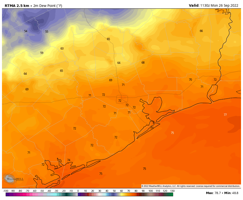
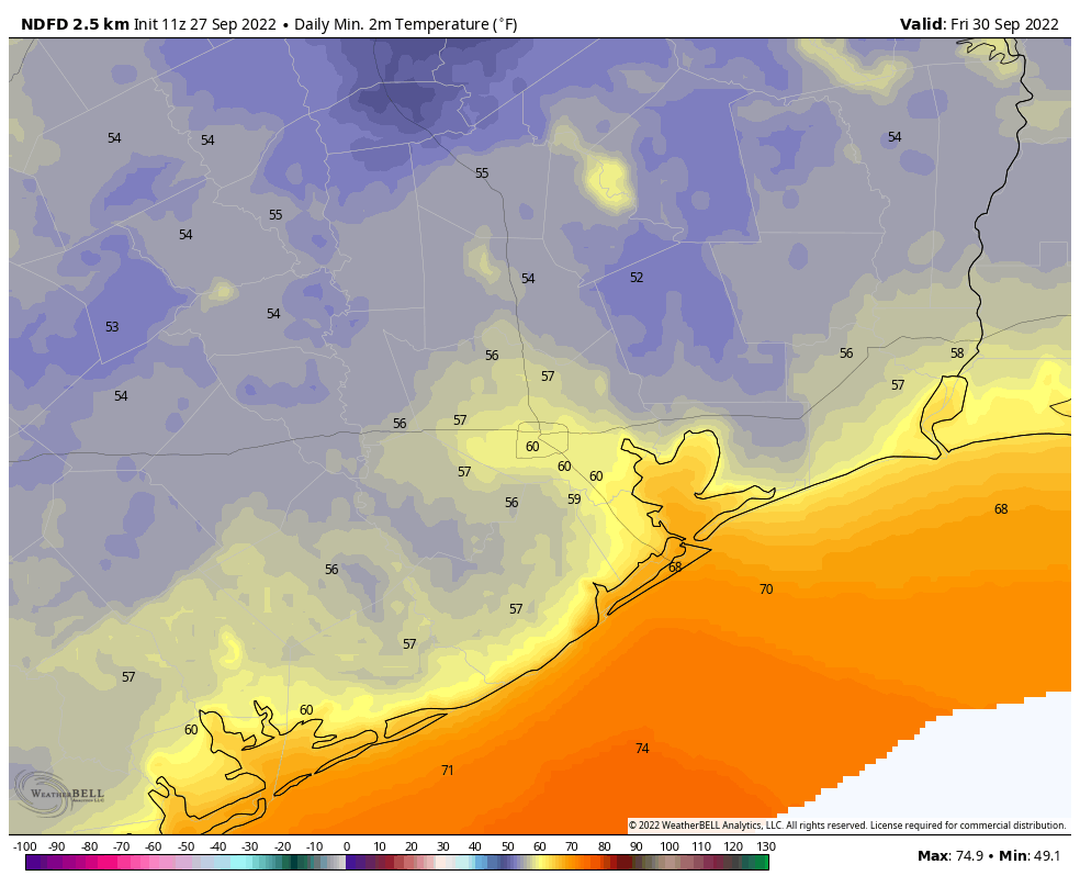
Temperatures are starting out in the 50s north of Houston, while most of the rest of the region away from the coast is in the low 60s. With dewpoints down around 50 degrees it feels fantastic outside. Given this drier air and clear skies, our air will still warm efficiently this afternoon, with high temperatures reaching about 90 degrees. Winds are light, out of the northeast at 5 to 10 mph. Lows tonight should again drop into the upper 50s for inland areas, with much of the metro area in the low 60s.

Wednesday, Thursday, and Friday

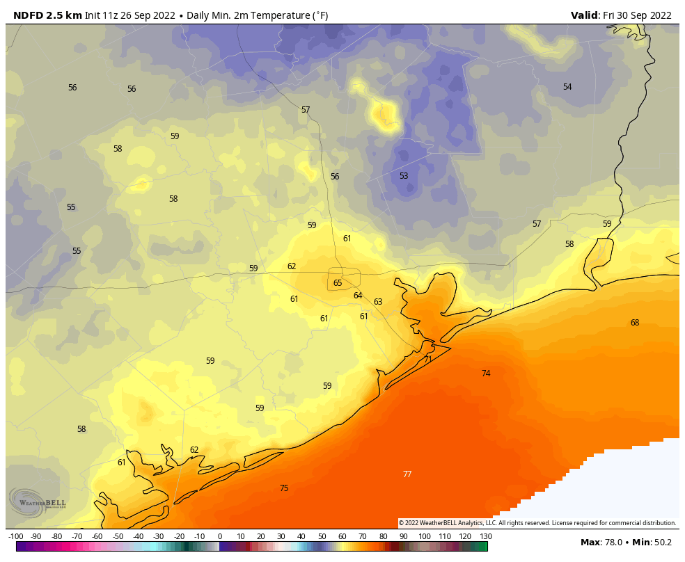
The remainder of the week should bring more of the same: warm sunny days, clear and cooler nights, and plenty of dry air. Northerly winds may turn a bit gustier by Thursday or so, as our region falls on the backside of powerful Hurricane Ian. As a result, this will be the rare early fall front that not just hangs around, but brings even cooler weather a few days after the fact. Lows this week will probably reach their coolest level by Thursday night or Friday morning, when more of the region has a chance to dip into the 50s.

Low temperature forecast for Friday morning. (Weather Bell)

Saturday and Sunday

The weekend should bring more of the same, although with atmospheric moisture levels starting to rise again we will see a bit of humidity. Even so, right now I anticipate dewpoints to be in the 50s, which means the air will be much more comfortable than our typical, sticky summertime dewpoints in the 70s. Look for highs of around 90 degrees this weekend, with lows in the 60s. Rain chances remain near zero.

Next week

We’re probably headed back toward highs of around 90, with nights in the low 70s, by next week. While the air becomes more humid, at this point it doesn’t look to be oppressively so. Now that we’re entering fall we can probably expect a front every week or two, but there’s nothing concrete on the horizon after this week’s cooler air. The real sore spot in the forecast is the lack of rain, and right now I don’t have anything hopeful to say about that, I’m afraid.

Hurricane Ian is going to be a disastrous storm for Florida. (NOAA)

Tropics

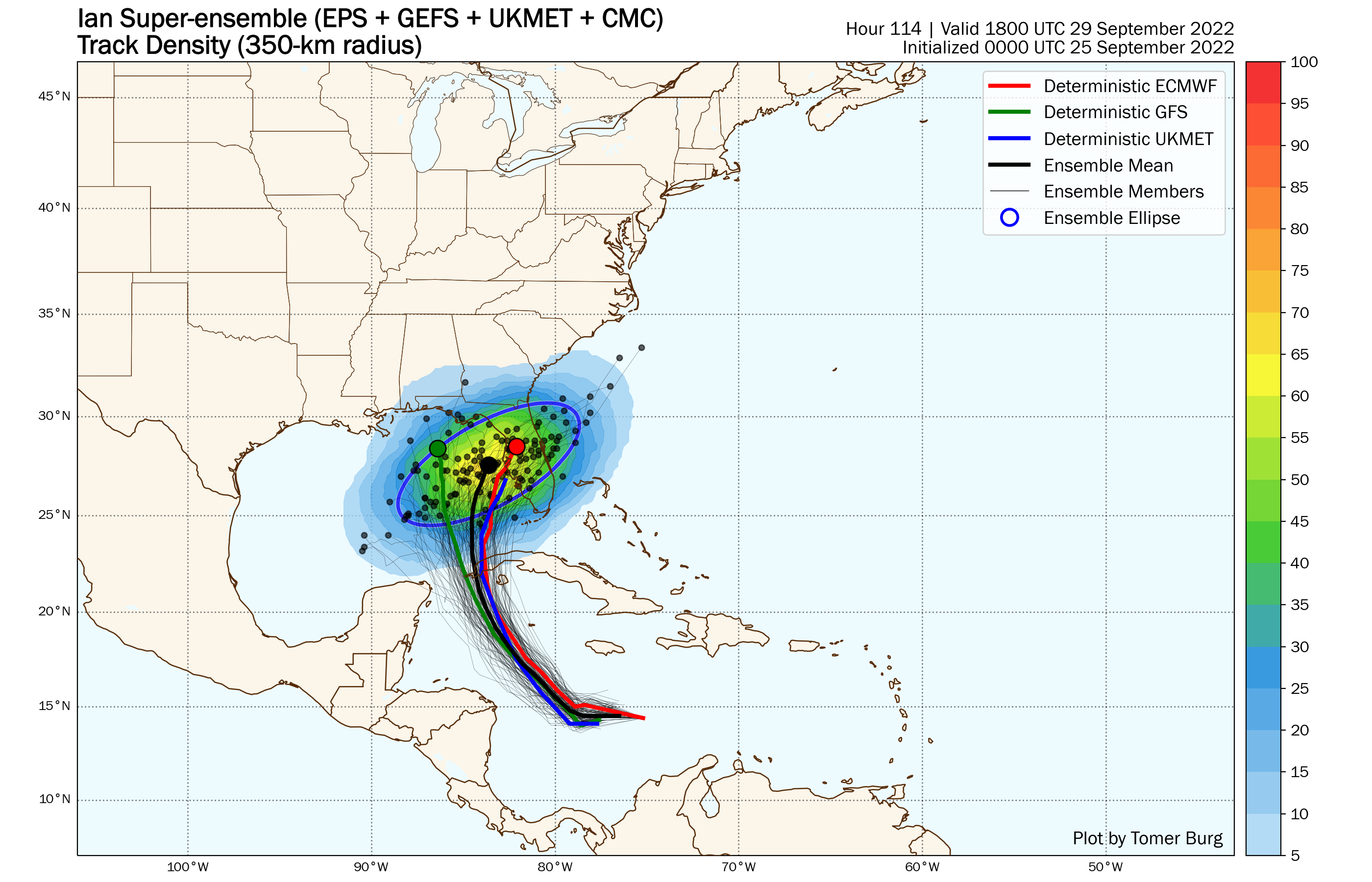
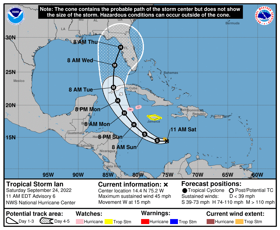
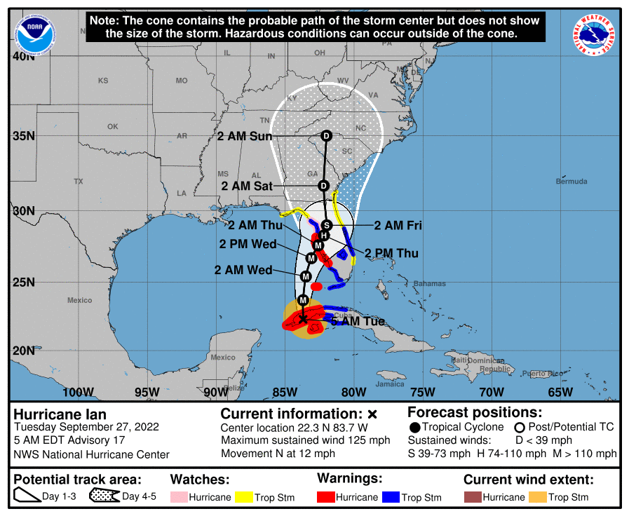
Ian has strengthened to become a major hurricane overnight, and will emerge from the western edge of Cuba this morning into the warm southeastern Gulf of Mexico, where it will find low shear and conditions that support further strengthening. This will be a historic storm for Florida, with the potential for devastating storm surge in the Tampa area, as well as points south. Wind damage will also be extreme for some locations. And in a final gut punch, the storm will slow down with weaker steering currents as it nears Florida. Houston residents who remember Harvey know what this means, very heavy rainfall. I expect parts of the Florida peninsula to receive 20 inches or more of rainfall during the next three to four days.

Fall’s first real cold front will push into Houston today, and it will stay around for awhile

My friends it has been a long—so very long —summer. We have seen record warmth in June and July, and plenty of high temperatures in the upper 90s during the last week. A total of 131 days have come and gone since Houston’s high temperature first hit 95 degrees this year, on May 18. Fortunately, I’m pretty confident that today is the last day of summer 2022.

Oh, we’re still going to see some 90-degree days. There will still be some humidity, of course. But our first real front pushes in today, bringing with it a nice surge of drier air tonight. By Tuesday morning it’s going to feel quite a bit different outside. No, the days won’t be chilly, but the nights will feel like fall. And the dry air is going to feel pretty amazing. Additionally, unlike a lot of early fall fronts, this one will have sticking power. The dry air should last into the weekend. So enjoy what’s coming, because you earned it.

Meanwhile, there’s likely to be a major hurricane coming to Florida this week. We’ll discuss that below as well.

Monday

There’s no way to sugarcoat the fact that today is going to be hot again. Expect highs to generally reach the low-90s across the region, with sunny skies. Light winds will turn to come from the northeast later today as the front pushes into the area. We don’t expect much (if any) precipitation with this front, and the bulk of the dry air will lag its passage, moving in tonight. Low temperatures tonight should drop into the mid-60s in Houston, with cooler conditions inland.

A dewpoint analysis on Monday morning shows a cold front on Houston’s doorstep. (Weather Bell)

Tuesday

You’ll be able to feel the drier air when you step outside on Tuesday morning. The lower humidity, combined with sunny skies, should allow highs to push into the upper 80s to 90 degrees, but temperatures will start falling fairly quickly after the sun goes down. Look for overnight lows in the mid-60s again in Houston, with cooler weather further inland.

Wednesday, Thursday, and Friday

If anything, the flow of drier air should become more pronounced during the second half of the week as Hurricane Ian moves into the eastern Gulf of Mexico. This should allow for warm, sunny days in the upper 80s and lows in the 50s (inland) and lower 60s for Houston. Mornings and evenings will be spectacular, y’all.

Friday morning could be the coolest of the week for Houston. (Weather Bell)

Saturday, Sunday, and beyond

By Saturday or Sunday, the onshore flow will probably start to reestablish itself. But at this point I still think we’re going to see sunny days in the upper 80s with at least somewhat drier air. Nighttime temperatures will start to warm, but should remain in the 60s. Highs next week probably climb back to around 90 degrees. I know we could really use some rainfall, but there appears to be precious little of that in the cards for the next 10 days or so.

Hurricane Ian

Ian continues to organize this morning, and has become a hurricane. This is the Atlantic season’s fourth hurricane and confidence is high that it will cross Cuba tomorrow and move into the southeastern Gulf of Mexico. By Wednesday it should be approaching the Tampa area on the West coast of Florida, where it could bring historic wind and storm surge damage. However after Wednesday there is considerable uncertainty about whether Ian will plow into Tampa Bay, move more or less due north up the West coast of Florida, or remain 50 or 100 miles offshore while turning north for the Big Bend region of Florida.

Monday morning track forecast for Hurricane Ian. (NOAA)

I’ve been tracking the potential impacts on NASA’s Artemis I mission closely. The large Space Launch System rocket and Orion spacecraft remain on the launch pad at Kennedy Space Center, on the east coast of the state. At least minor impacts are likely, and Ian’s effects could become more direct. As of this morning, the probability of tropical storm force winds at the space center are 60 percent, with an 8 percent chance of hurricane-force winds. They could arrive as early as Wednesday. NASA officials are meeting at 11am CT today to decide whether to roll the Artemis I mission back inside the Vehicle Assembly Building to protect the vehicle.

Tropical Storm Ian inching forward with sights set on somewhere in Florida

Good Sunday to you. With the potential of a major hurricane in the Gulf in 3 days, we just want to post to reassure our Houston readers that this storm will not impact Texas and offer an update for our neighbors to the east.

Just to reemphasize, for Houston, we are in fine shape. The window of impacts from Ian has likely narrowed from east of New Orleans through most of Florida.

As of Sunday morning, Ian has maximum sustained winds of 50 mph. Reconnaissance aircraft traversing the storm are not finding anything super noteworthy this morning. Ian remains a tropical storm trying to organize itself. The satellite picture is less than overwhelming.

Ian doesn’t look like a classic tropical storm or even a tropical storm at all really. But the expectation is that Ian will rapidly organize tonight and tomorrow. (Tropical Tidbits)

That said, with a generally favorable environment surrounding it, Ian should be able to rapidly intensify at some point in the next 36 hours. If Ian continues to struggle some into tomorrow, the odds of that drop but by no means does the lack of organization indicate much about the long term peak of Ian at this point. Rapid intensification happens…rapidly. Despite the raggedness at the moment, Ian is still likely to become a major hurricane as it moves into the southeast Gulf of Mexico.

What will impact Ian’s intensity at landfall is exactly where it tracks. If the storm turns right faster and plows into Fort Myers through Tampa, Ian will likely be near peak intensity as it does so, a really bad situation. If the storm heads more north toward the Big Bend or Apalachicola Bay, the storm should be a bit under peak intensity as it comes ashore. If the storm goes farther west toward Pensacola or Mobile, the hope would be that Ian would weaken even a bit faster. Why? Wind shear. That being said, if a more northerly/westerly track does occur, Ian will be expanding in physical size, meaning a larger wind field. While this wouldn’t be quite the same as another “I” storm we are familiar with (Ike, which also weakened on approach to landfall), the idea would be the same for Florida: A very strong, powerful storm increasing in size but weakening at landfall can still produce very damaging impacts, and whatever the “category” of the storm, folks in Florida should be taking this seriously.

So where will Ian go? That’s the million dollar question, and I have to say, the forecast track of Ian is fairly complicated this close to impact time. The National Hurricane Center outlook shows Ian coming in somewhere between roughly Fort Myers and Pensacola.

The National Hurricane Center shows Ian developing into a hurricane by tomorrow and a major hurricane by Tuesday, with a strike on the Florida coast, somewhere between Fort Myers and Pensacola by mid to late week. (NOAA)

This is as good a forecast as any in my personal opinion, and I think it correctly splits the risks down the middle. If we look at a more complicated map of what we call a “super ensemble” of a bunch of different ensemble models, you get a very similar looking cone.

The multi-model ensemble view of Ian, which takes multiple different model ensemble members shows that on Thursday afternoon, the center of Ian will likely be from somewhere over the Peninsula to perhaps approaching the western Panhandle, right in line with the NHC forecast. (Arctic Wx/Tomer Burg)

We use this approach to get a better sense of risk and/or consensus within the modeling itself. There are quite clearly two camps it seems; one that brings Ian near Tampa and another toward the Panhandle. But there is ample potential in between too. So this is another instance in which you have to look at the entire cone as being at risk versus just a point on a map. Hopefully we can narrow this further as today goes on so folks can begin to prepare adequately.

For now, if you know anyone in Florida or visiting Florida, they should be ready to act sooner than later. Impacts would hit southwest Florida by Wednesday or the Panhandle by later Thursday depending on the track.

As far as the Artemis I mission goes, the decision to delay the launch happened yesterday, and according to NASA, they will decide tonight on whether or not to rollback. Very difficult and consequential decisions here. Increasingly, the length of time needed to adequately prepare for storms and issue directives is longer than what is realistically possible from a weather prediction scenario, particularly when it comes to Gulf systems. This is another reason why hurricane preparedness plans are so important. You’ll almost always have less time than you think.

We’ll have another update on Ian tomorrow, as well as an update on the rest of our Houston area forecast. We are still on track for a cold front tomorrow that will usher in cooler and more comfortable weather probably through the weekend! Daytime highs will still be hot, near 90 or well into the 80s most days, but the humidity will be low, allowing for nighttime temperatures in the 60s and perhaps 50s inland. More tomorrow!

Tropical Storm Ian is bound for the southeastern Gulf of Mexico as a powerful hurricane

Please note: Tropical Storm Ian is highly unlikely to have direct impacts on Texas, aside from some coastal swells later next week. In fact, a reasonably strong cold front remains on track for Houston on Monday, bringing cooler and much drier air—dewpoints in the upper 40s, anyone?—into the region for most of next week. However, we continue to get questions about Ian, and with NASA’s Artemis I mission on the launch pad in Florida I thought it prudent to offer an updated forecast on the storm.

What we know

As of late Saturday morning, Tropical Storm Ian still has not developed a well defined center of circulation and has a vertical structure that is tilted. This means the storm is still struggling to get organized. However that could soon change, as wind shear near Ian lessens and the storm passes over very warm waters in the Caribbean Sea. Our best way to measure this is through a variable known as “tropical cyclone heat potential,” which measures not just the sea surface temperature, but the depth of this warm water, which is important as a tropical system churns up water from below. A value above 80 is conducive for intensification. With values of 100 to 120 in Ian’s path, the storm is poised for rapid intensification during the next two days if it can align its inner core. Most likely, Ian will be a hurricane on Monday as it approaches Cuba.

Tropical cyclone heat potential with Hurricane Ian’s forecast track superimposed. (NOAA)

We also are fairly confident in Ian’s track through Monday, as it should pass to the south of Jamaica and then turn northwest toward the western edge of Cuba. It should then emerge in the southeastern Gulf of Mexico by Monday night or Tuesday morning. At this point I think it will probably be far enough west of the Florida Keys to spare those islands the worst effects, but I am not prepared to guarantee that.

What we don’t know

Unfortunately, after Monday night there is a lot of uncertainty in the track forecast for Hurricane Ian. One of the reasons for this is because the center, as yet, lacks definition. The models are struggling with its starting point, and this leads to wide variances in its position three to five days from now. However, there has been a clear trend during the last 24 hours in which Ian’s track has gradually shifted west, such that the National Hurricane Center’s best track (at 10am CT Saturday) lies on the eastern side of the model guidance.

Tropical Storm Ian forecast track at 10am CT on Saturday. (National Hurricane Center)

It remains plausible that Ian could make a landfall anywhere from southwestern Florida to southeastern Louisiana next week, and these regions should absolutely remain vigilant. But at this time the most likely location is somewhere between Destin and Tampa, Florida. Until the center is better defined, and the models are more coherent, great uncertainty will remain. This situation should get better during the next 24 hours assuming that Ian’s structure improves, and the forecast models ingest data being gathered by NOAA aircraft flying in the storm’s vicinity today.

As for the Artemis I mission, NASA has canceled a planned launch attempt on Tuesday, September 27. It has also delayed a decision on whether to roll the rocket back into the Vehicle Assembly Building (where it could safely ride out a hurricane) until Sunday. This is prudent, given Ian’s slower movement. At this point I think there’s a pretty decent chance that it will be safe for the rocket to remain on the launch pad, preserving a launch opportunity on October 1 or 2. The forecast should be clearer by Sunday, when NASA aims to make this roll back decision.