After a warm weekend, cool, crisp autumn air is coming for Houston next week

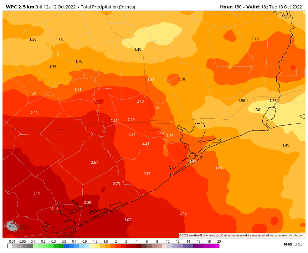
The Astros weren’t the only winners on Thursday. Some folks saw actual rain yesterday too. The jackpot winners came in about three different areas: Dickinson in Galveston County, Fresno and Sienna Plantation, and just south of Sealy. There were a few other spots south and west of the Houston area that did okay as well.

Rain was mostly confined to areas southwest, south, and east of Houston yesterday. Click to enlarge. Green is > 1.5″, purple > 2″, blue is near 3″, and yellow (near Sienna Plantation & Dickinson) is over 3″. (RadarScope)

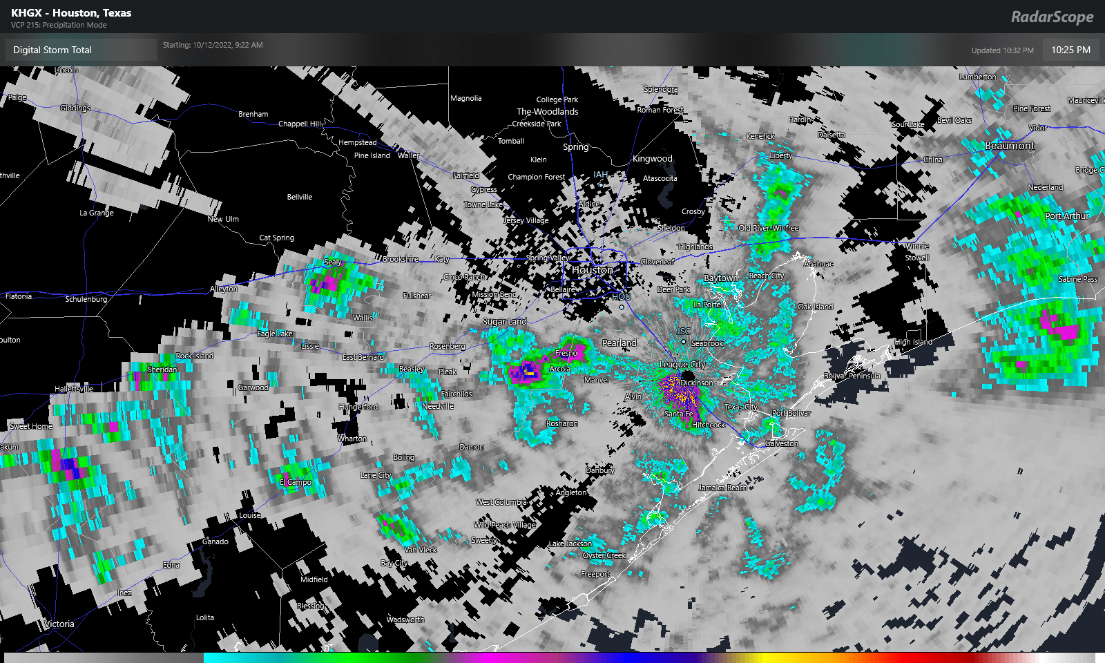
The highest measured totals I could find were near Dickinson (3.16″), Southfork (2.04″), and La Porte (1.96″). Yesterday’s Drought Monitor update underscored our need for rain, as drought coverage expanded by another 12 percent in the Houston region.

Drought coverage continued to expand in the Houston region over the last week, now covering almost 70 percent of the area. (US Drought Monitor)

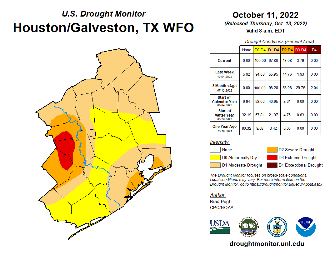
The good news is that we have more rain chances coming. The bad news is that these will likely do little to alleviate the underlying problem.

Today

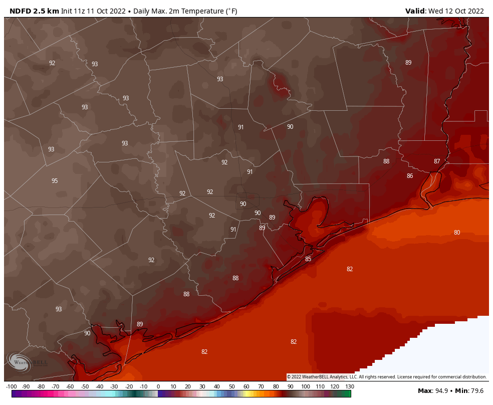
All in all, today should be decent, albeit hot. The front has cleared most of the area, and we have slightly lower humidity in place now, but that drier air with sunshine will allow temperatures to efficiently heat up. Someone should hit 90 degrees today, but most of us will top out in the mid to upper-80s. A shower can’t be completely ruled out south of the city toward Matagorda Bay.

Weekend

Saturday looks to be a fairly uneventful day with sun, clouds, warm and more humid air, and just a very, very slight shower chance. Temperatures will warm from the 60s into the upper-80s to near 90 degrees or better in spots.

Sunday looks a little bit more interesting in terms of rain chances. I think most of us will see no rain, but there will be some neighborhoods that will host a shower or storm on Sunday. We’ll go from near 70 in the morning into the mid-80s, if not upper-80s by afternoon. I’d expect the shower chances and some additional clouds to hold temperatures down a degree or two relative to Saturday though.

Monday

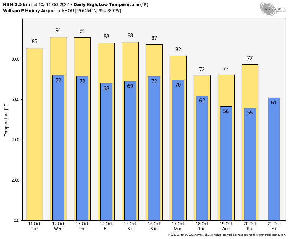
Alright, our much ballyhooed front is still expected to arrive here in Houston on Monday. It’s still a bit too early to get too cute on timing, but I would expect the best chance of storms later in the day or evening, followed by gradual clearing late Monday night or early Tuesday. Clouds, showers, and the front should combine to keep our temperatures from warming much beyond the upper-70s on Monday.

The rainfall forecast through early next week looks most helpful well south and west of Houston, while our area sees generally 0.5-0.75″ or less. (Pivotal Weather)

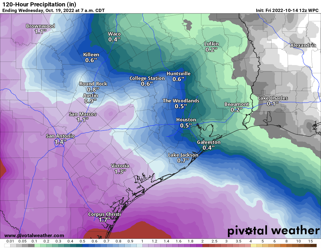
Rain totals are likely to vary, and because of the relatively progressive nature of the front, we will probably see a half-inch to three-quarters of an inch or less in most areas. This will certainly help take the edge off a bit given recent dryness, but it will do little to actually dent the burgeoning drought in our area.

Rest of next week

The Tuesday through Thursday period next week is being delivered by Yordan Álvarez, because it’s a home run. Expect three days of sunshine, low humidity, and cool, crisp autumn air. Highs will be in the low-70s, cooler perhaps on Wednesday and warmer on Thursday. Morning lows? Yeah, we have a shot at 40s.

Thursday morning lows may dip into the 40s across much of the area away from the coast. (Pivotal Weather)

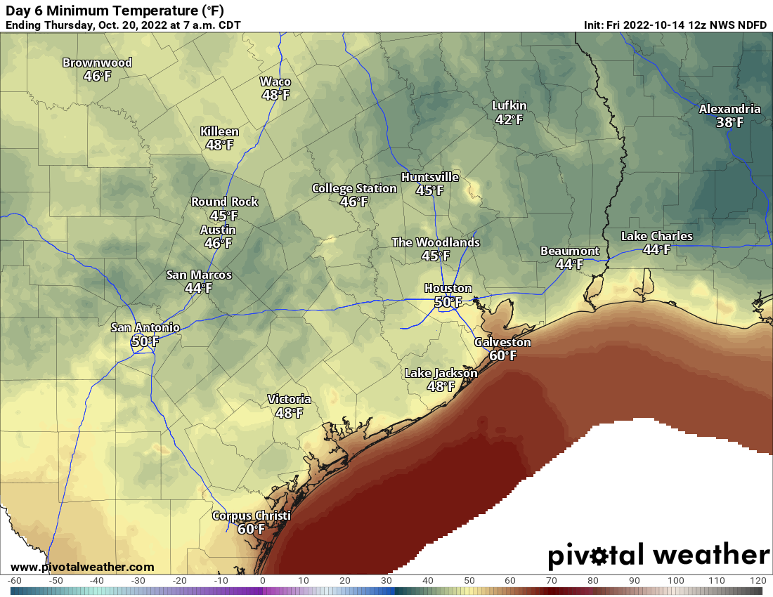
Expect 50s area-wide next Wednesday, Thursday, and Friday mornings. Much of the area will probably be in the 40s on Wednesday and Thursday morning. Beyond that, we’re probably looking at a warm up next weekend into the week of the 24th. More on that next week.

Houston may finally get significant relief in terms of rainfall, and cooler weather

A few readers may have heard some thunderstorms as a weak cool front moved down into the Houston region this morning. These storms are fairly isolated, and should move southward as the front pushes off the coast after sunrise, later this morning. This will bring a brief reprieve from Wednesday’s heat and humidity, but for truly fall-like conditions we’ll need to wait for a stronger front to arrive on Monday. This one should bring glorious weather, as well as a nice dose of much-needed rainfall with it.

Thursday

High temperatures today will reach about 90 degrees, and it will take some time for the drier air to work into the region following the frontal passage. With the front stalling near the coast, high resolution models are showing the potential for some additional showers and thunderstorms to fire up this afternoon and early evening over Houston. I expect them to be fairly scattered, however. As drier air moves in, expect lows tonight to drop into the 60s for Houston, and showers to end.

NOAA rain accumulation forecast for now through Monday. (Weather Bell)

Friday

Don’t blink, otherwise you’re going to miss the front’s impact on our humidity. That’s because dewpoints are expected to only briefly bottom out on Friday morning before humidity levels start to rise again. Friday should see mostly sunny skies, with highs in the upper 80s and light winds turning southeast. As this more moist flow resumes, lows on Friday night should be a few degrees warmer than Thursday night.

Saturday

The first half of the weekend looks sunny and warm, with high temperatures near 90 degrees. Humidity will be back, in abundance. Enjoy your last day of full-on summer, you diehards.

Sunday

The atmosphere will start to become a bit more perturbed by Sunday, as a disturbance or two passes over the region, ahead of the next front. So while Sunday morning should be partly sunny and warm, there will be an increasing chance of showers and thunderstorms later in the day, and overnight. Look for highs in the mid- to upper-80s depending on cloud cover and rainfall at your location.

Monday

Cold front day! A stronger front should move through Houston on Monday, and this will also support the best chance of rainfall. Much of the area should see 1 to 2 inches of rainfall through Monday night, but as usual some parts of Houston will get more, and others less. Highs on Monday may only reach the upper 70s, depending on the timing of the front, and how far away from the coast you live. Lows on Monday night will probably drop into the upper 50s for most areas away from the immediate coast, but again this depends on the timing of the front.

Here’s a (very) early preview of low temperatures in Houston next Wednesday morning. (Weather Bell)

Next week

As for the rest of next week, well, it looks pretty freaking great. I’m expecting at least a few days with highs in the 70s and lows in the 50s (for Houston) and 40s for areas further inland. Fall is here, baby, and it’s going to be spectacular.

I don’t want to talk about this week’s weather, I want to talk about next week’s front and rainfall

Good morning. Houston faces four or five more fairly warm to hot days—today should be the hottest—before the arrival of a fairly robust cold front. The really good news about this front is that there should be plenty of atmospheric moisture to work with, so our confidence has begun to increase in a pretty healthy amount of precipitation accompanying the front. While it’s too early for precise information, 1 to 3 inches of rain would go along way toward ameliorating some of our recent dryness.

Wednesday

Today is going to be pretty muggy as tropical moisture moves into the area. Highs should push into the low 90s for much of the region, with partly to mostly sunny skies, and some of the highest humidity levels we’ve seen in a while. Winds will be light, generally out of the southwest. A weak front will approach the region this evening, and this should spark a 10 to 20 percent chance of rainfall late this afternoon, evening, and overnight. Don’t expect rain, and then you won’t be disappointed when it fails to materialize. Lows will drop into the low 70s tonight.

Relative humidity is pretty much 100 percent on Wednesday morning. (Weather Bell)

Thursday

As a modest amount of drier air filters in on Thursday, we can expect sunny skies and highs near 90 degrees. The evening hours should be pleasant, with drier air and temperatures in the upper 70s. Overnight lows will drop into the mid- to upper-60s for the region.

Friday

Drier air starts to go away as winds turn to come from the southeast. Look for sunny skies and highs of around 90 degrees. Lows on Friday night will be a couple of degrees warmer than Thursday night.

Saturday

The first half of the weekend will see humidity levels rise, and partly sunny skies. As moisture levels rebound, we will probably have about a 20 percent chance of rain. Look for highs near 90 degrees once again, with a warm and humid night.

Sunday

Rain chances on Sunday are better, perhaps 40 percent, but I expect showers to remain fairly scattered. Look for more clouds, and as a result highs in the mid-80s.

Monday and beyond

The stronger front looks set to arrive some time on Monday, and combined with a moist atmosphere, this will bring our region’s best chance of rain in more than a month. Forecast models are still quite variable in their outcomes, but I think much of the region should see at least 1 inch of rain, with the potential for more. I am quite optimistic about this right now, but since this remains five days out we just can’t offer any guarantees.

Colder and drier air after the front is coming, however, and I expect Houston to see at least a few days with highs in the 70s and lows in the 50s. Some inland areas may even touch the 40s by Wednesday or Thursday morning, if you can believe that.

Preliminary NOAA rainfall accumulation forecast for now through Tuesday morning. (Weather Bell)

Tropics

Tropical Storm Karl has formed in the Gulf of Mexico. Should you be concerned if you live in Texas? No. We told you more than a week ago that the Texas hurricane season was over, and when we’re that definitive on something you should probably trust us. The storm could bring heavy rainfall and flash flooding to parts of the Veracruz and Tabasco states on Mexico this week, however.

Houston’s long run of 90-degree days in 2022 may soon come to an end

Houston recorded its first 90-degree day this year way back on April 5, a little more than six months ago. Since then Houston has recorded a total of 130 days of 90-degree weather, or warmer. My bold prediction this morning is that, after a few more such days, we’re done with 90-degree temperatures for 2022. Put another way, after this week, we can chunk 90-degree weather in the bin for about six months.

Tuesday

Alas, we’re not there yet, and we will see rather warm weather this week. Look for highs today in the upper 80s, with mostly sunny skies. It won’t be full-on humid outside, but the air will start to feel more moist than it has in days past. Winds will be light, out of the southeast. Low temperatures tonight may not fall below 70 degrees in the city of Houston.

Wednesday

This is going to be a really hot day for mid-October, with high temperatures in the low 90s. Skies will be partly sunny and humidity levels are going to surge. So be prepared to sweat when you step outside. This moisture will help lead to some cloud cover, and there is a slight potential for some rain during the daytime on Wednesday, but it is only 20 to 30 percent, so if you see any rain, you should feel lucky.

Highs on Wednesday will be hot and steamy. (Weather Bell)

Thursday and Friday

A weak front arrives by Thursday to bring some relief. It won’t be much, but it may knock highs back into the upper 80s, and bring enough dry air to make the humidity a bit more tolerable. Nighttime lows should drop back into the upper 60s for Houston, with slightly cooler weather inland.

Saturday and Sunday

Summer’s last hurrah? Probably not, as we’re still going to see warm weather in 2022. But this will be one of the last truly warm weekends of the year with highs in the upper 80s to 90 degrees, and mostly sunny skies. A chance of rain returns to the forecast on Sunday as atmospheric moisture levels increase, and our weather becomes more disturbed due to the approach of a stronger front.

Change is coming? (Weather Bell)

Next week

My confidence is increasing in the arrival of a real cold front next week, probably on Monday. This will bring us our best chance of rainfall in what seems like forever, although it is still too early to have much ability to predict how much. It’s not out of the question that much of the area sees on the order of 1 inch, however. I think lows will drop into the 50s next week, in the wake of the front, but again that’s not something we can lock in just yet. But, I’m hopeful.