Only modest rain chances this week, but we see some promising signs in the longer-term forecast

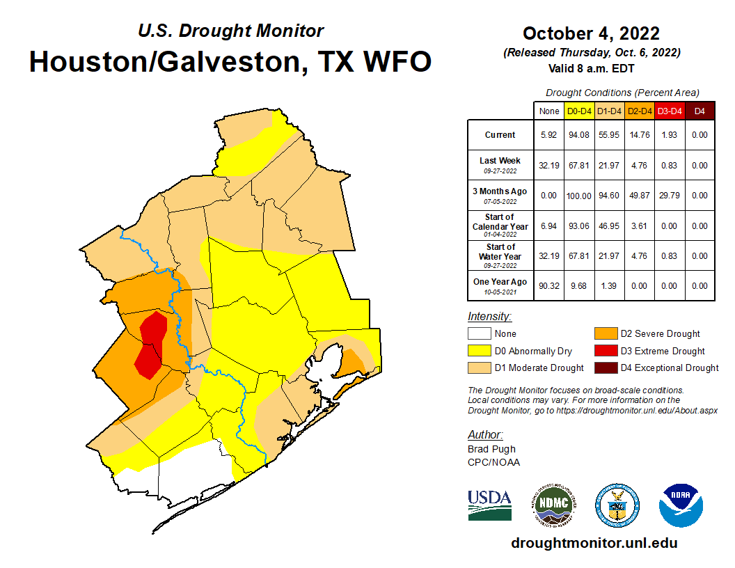
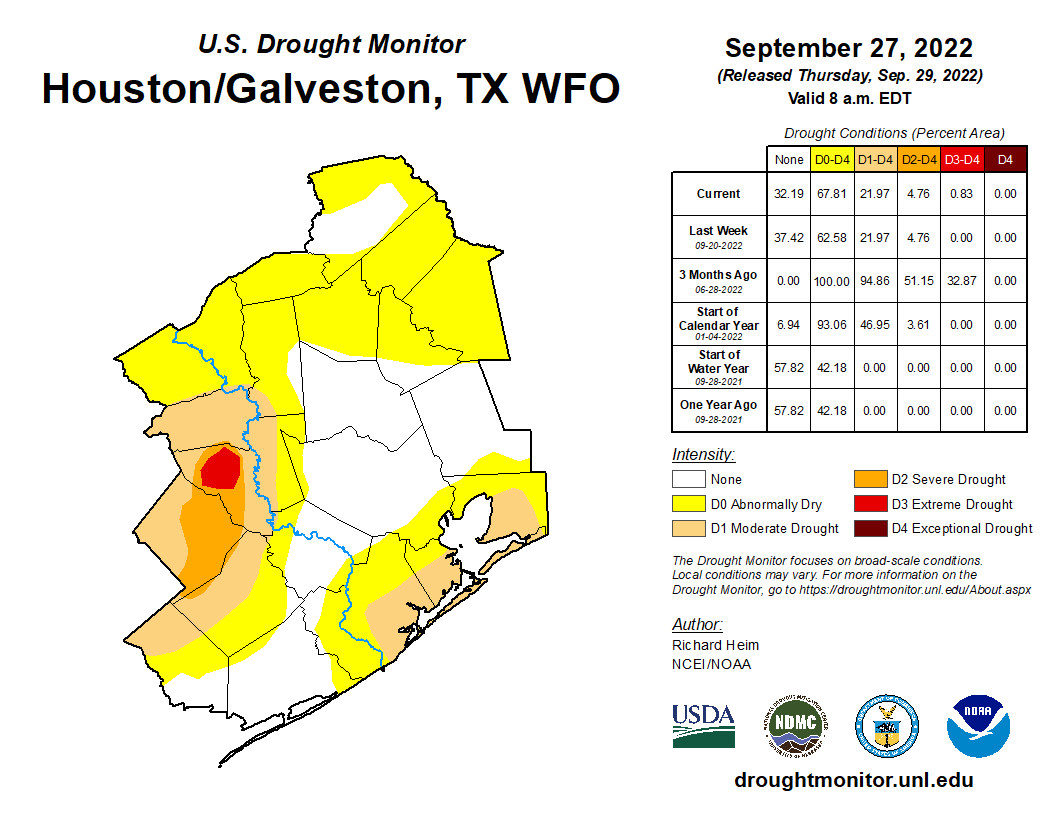
Good morning. As Matt wrote last week, our region’s start to fall is the driest on record. Unfortunately, I do not expect that to change much this week, although some modest rain chances will return. This week will also be warmish, with a few days flirting with 90 degrees. However, I’m starting to see some potential for our weather to turn wetter and cooler about one week from today. Emphasis on potential.

The state of Texas is enjoying a pleasant start to Columbus Day with these sunrise temperatures. (Weather Bell)

Monday

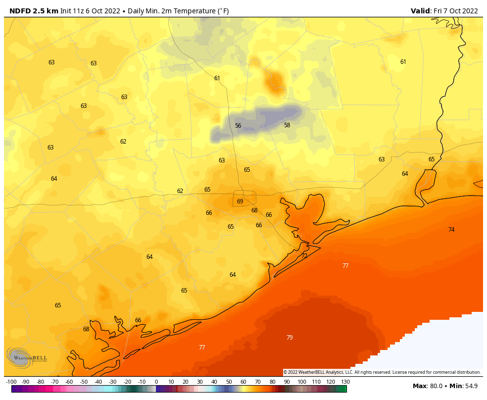
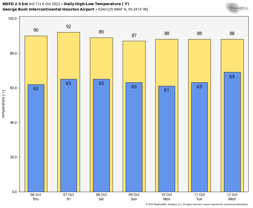
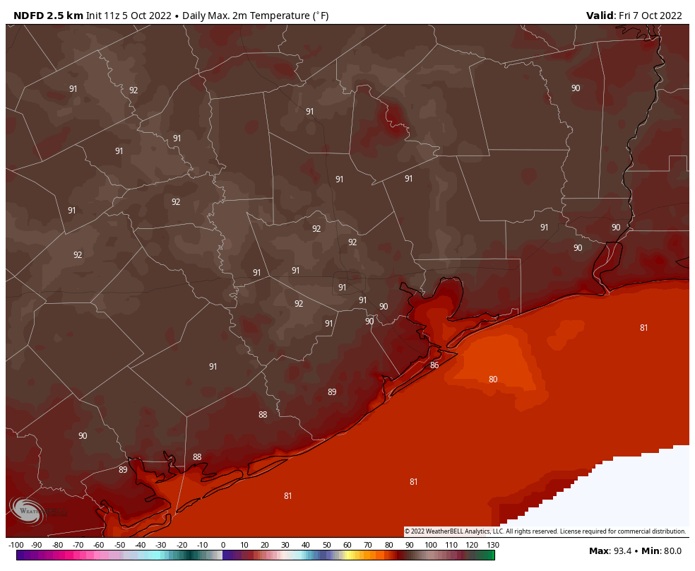
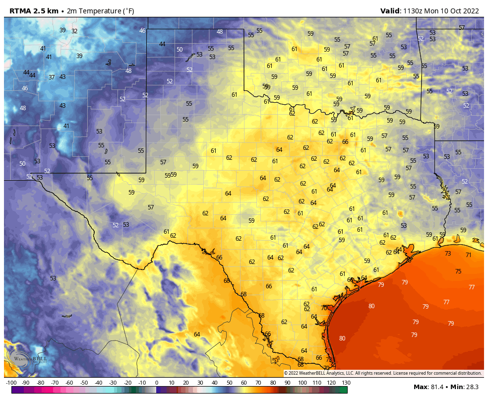
Temperatures have generally fallen into the low 60s this morning, although the usual locations further inland are seeing lows in the upper 50s. Today should be similar to Sunday in that we see highs in the upper 80s with mostly sunny skies, and light northeast winds of 5 to 10 mph. As some dry air holds on most of the city should drop into the mid-60s tonight, with clear skies.

Tuesday

Highs and skies will be similar to Monday, with temperatures in the upper 80s and mostly sunny skies. However we’re going to see southeasterly winds and a corresponding increase in humidity. As a result we can expect lows Tuesday night to be warmer, possibly only dropping to around 70 degrees.

Wednesday

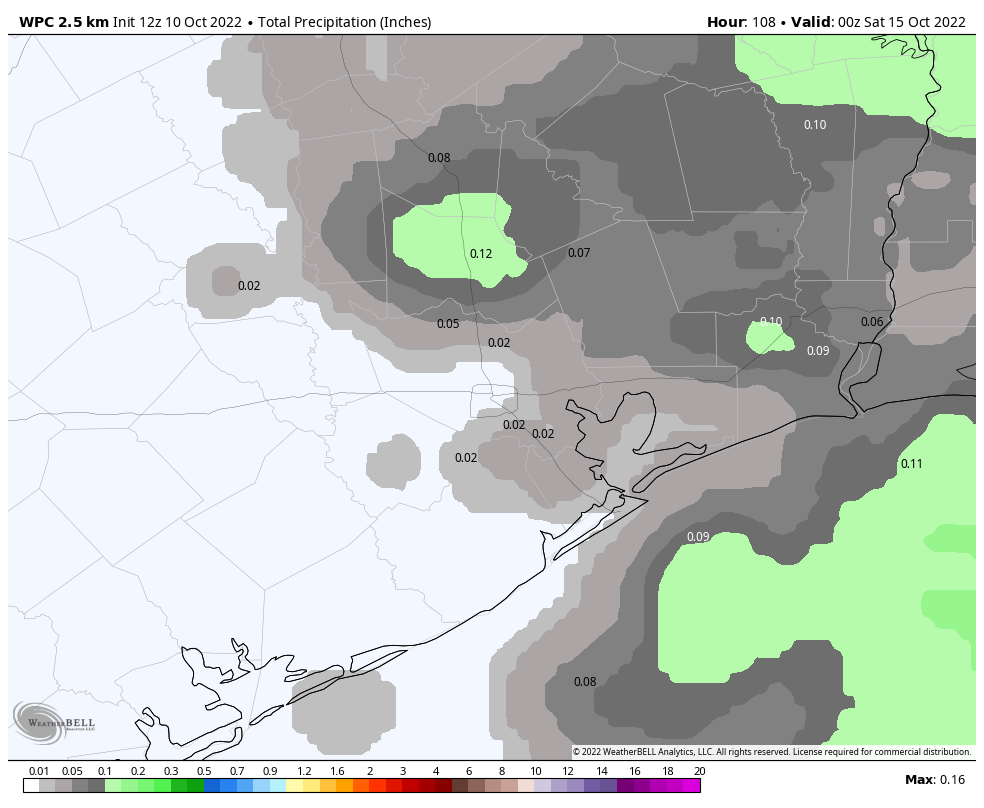
There is an honest-to-goodness chance of rain on Wednesday, but unfortunately it’s probably only about 30 percent. The forecast has trended drier, in terms of rain, despite a decent influx of moisture from the Gulf of Mexico. Some areas may pick up a quarter of an inch of rain, or so, but I think much of the region will only see some clouds. At the same time, this moisture will really bump up humidity levels, so this is going to feel like a pretty warm summer day with highs perhaps in the low 90s. It’s difficult to see too many more days like this in 2022, so you summer lovers make sure and soak this one up.

NOAA rain accumulation forecast for now through Friday. (Weather Bell)

Thursday and Friday

A weak front should push into the area early on Thursday. Don’t expect miracles from this one, but it should be enough to drop temperatures back into the upper 80s, with drier air, and push nighttime lows into the 60s. Mornings and evenings should feel pretty nice.

Saturday and Sunday

The front should wash out by the weekend, so we’re going to see humidity levels start to return. I’d expect highs somewhere in the mid- to upper-80s with mostly sunny skies. I’m honestly not sure about the potential for rain. With the onshore flow I think it’s possible, but for now I’d peg daily chances at only 20 or maybe 30 percent, with perhaps a bit higher likelihood on Sunday. We’ll see.

Next week

We’re getting to the limit of weather forecast models by Monday or Tuesday of next week, but there is a decent signal for potentially a stronger front to push into Houston around that time, accompanied by a pretty healthy chance of rain. If this happens I think much of the area could see a nice soaking, followed by cooler weather. The bottom line is that right now we may be seeing a light at the end of the tunnel for a very dry fall. Hopefully it’s not an oncoming train.

Houston’s driest start to meteorological fall in nearly 70 years

Since September 1st, Houston has registered a mere three-quarters of an inch of rain, which is the driest start to meteorological fall (September-November) since 1953 (0.47″). More recently, 1992 only saw 1.08″ and the drought-ridden 2011 only saw 1.28″ of rain in that same time period. It’s the fifth driest start to autumn on record.

Slide the bar on the image above to see the week to week comparison of drought coverage (and statistics) across the Houston area. (NOAA)

As you’d expect, with yesterday’s drought monitor update, coverage of drought conditions in the Houston area increased by over 30 percent week over week. We need rain. October is normally our second wettest month of the year (trailing only July). We average over 5 inches of rain in a typical October. Hopefully we are able to cash in on some rain chances next week. Otherwise, watch for drought coverage to expand even more in the days ahead.

Today

No rain in the meantime. Houston officially hit 90 degrees on Thursday, and we’ll feel a touch hotter today. Look for low 90s and a bit of humidity. Clouds will mix with some sun and haze otherwise. Pollen remains painfully high due to ragweed, and air quality will remain on the poor side in the morning via smog and in the late day via ground ozone.

Weekend

Saturday looks fairly similar to Friday in most aspects. Morning lows may be a touch warmer due to clouds. Daytime high temperatures may be a couple degrees cooler, but we’ll see a good deal of sunshine emerge. Subtly, a weak front, which crosses the area later Friday, will start to usher in a reinforcing shot of dry air for the weekend days. We should notice a slightly more pleasant morning on Sunday with lower humidity during the day, despite highs in the still in the mid or upper-80s.

Morning lows on Sunday will be generally in the 60s with some 50s likely in outlying areas east, north, and west of Houston. (NOAA)

Aside from it being a bit warmer than usual, all weekend plans should be fine.

Early next week

Monday looks a lot like Sunday and Tuesday a lot like Friday. Does that make sense? Still pleasant but warm Monday and then warmer and a little more humid on Tuesday.

Mid to late next week

On Wednesday, it appears we actually get a legitimately strong surge of humidity into the area, which will make it feel more like late summer. Wednesday and Thursday seem unlikely candidates for “comfortable” weather. Look for upper-80s by day and 70s by night. Beyond that, there are questions as to the timing and strength of a cold front and how much moisture it will offer. That will determine the extent of our rain chances for next week. While I’m hopeful for some rain, this is not likely to be the drought-denter we are looking for.

Tropics

Here in Houston, we have no concerns. We have gotten some questions about the Caribbean disturbance, which is now Tropical Depression 13. The official forecast for TD 13 brings it due west across the Caribbean into Central America, specifically Nicaragua by the end of the weekend as a hurricane.

Tropical Depression 13 is expected to become a strong tropical storm or hurricane as it approaches the coast of Nicaragua this weekend. Hopefully its forward speed will limit severe impacts to Central America. (NOAA)

Thankfully, this is moving quickly and is abnormally far south, so hopefully that limits its intensity upside and subsequent impacts to Central America. But for those of you traveling to Cancun or Cozumel this weekend, you’ll be fine. Those of you with interests in other Central American nations will want to monitor this storm’s progress. The next name on the list is Julia.

A sunny and warm weekend lies ahead for Houston

It is another pleasant, early fall morning outside with lows generally in the low 60s. We are going to continue our recent warming trend for a couple of more days before some moderate relief arrives in the form of a weak front on Saturday. So the weekend looks pretty nice.

I’m still hopeful that we will finally start to see a bit of rainfall next week—College Station has not received measurable rainfall since September 7th, and it’s been more than three weeks for most of the region. Matt will have more on this tomorrow, and the reemergence of drought conditions in the region.

Thursday

If you look on the radar this morning, you’ll actually see some showers offshore in association with a low pressure system. Alas the atmosphere over land is pretty dry still, and I don’t expect this precipitation to move inland. Instead, we’re likely to see partly sunny skies today, with highs around 90 degrees or a touch above. Winds will be light, out of the north, at about 5 mph. Lows tonight will probably be a degree or two warmer than Wednesday night.

Lows on Thursday night will be fairly warm in the Houston region. (Weather Bell)

Friday

Friday will be similar to Thursday, although potentially just a bit warmer and with a few more clouds. Winds should again be light, generally out of the north. A weak front will move through late Friday and early Saturday morning, but it should hardly be noticeable as drier air will lag behind somewhat.

Saturday and Sunday

The weekend looks pretty alright in the wake of the front. You’re coming to the wrong place if you want chilly autumn weather in early October, and days should be in the upper 80s, with lower humidity. If that’s too hot for you, mornings and evenings should be rather pleasant, with somewhat drier air and lows in the low- to mid-60s. Skies will be mostly sunny, with rain chances near nil.

Columbus Day

If you’re off from school or work on Monday, it should basically be a continuation of Sunday’s weather, which is to say sunny and warm, and otherwise nice.

Houston will see a slight cool down this weekend, but the drier air will be nice. (Weather Bell)

Later next week

Atmospheric moisture levels should be on the rise next week, with the potential infusion of tropical moisture, helping to finally return some decent rain chances to the region by Wednesday or Thursday. It’s too early to have much confidence in totals or accumulations—but I wouldn’t expect miracles. Nevertheless this is literally our first real chance for rainfall in weeks upon weeks, so it’s better than nothing. And in the “more good news” department, it still looks more probable than not that a stronger front pushes into Houston later next week, possibly setting the stage for a pleasantly chilly weekend in the October 15 timeframe. We’ll see.

Houston will be warm and dry for the next week, but after that we may finally see some rainfall

Good morning. Our overall forecast remains more or less on track, with warming conditions ahead of a weak front this weekend, followed by the potential for a stronger front some time later next week. The good news is that while the next seven days or so do look dry, there is a pretty decent chance of some rainfall returning to the forecast by the middle of next week.

Wednesday

With high pressure more or less in control of our weather, we can expect highs today to reach near 90 degrees, with mostly sunny skies, to go along with light northeasterly winds. Rain chances are virtually zero. Once again, mornings and evenings should be fairly pleasant, with a modicum of drier air still hanging about. Low temperatures tonight will drop into the mid-60s for most of Houston, with slightly cooler conditions inland. If you find yourself sneezing today, it may be due to the ragweed levels, which are very high.

By Friday, much of the region will be at or slightly above 90 degrees. (Weather Bell)

Thursday and Friday

These will be a pair of warm days, with highs reaching about 90 degrees, or a few ticks above, to go along with sunny skies. The air will continue to get a little bit more humid, but nothing like summertime in Houston, so mornings and evenings will still be pretty decent. Lows will drop to around 70 degrees both nights.

Saturday and Sunday

A weak front arrives on Friday night or Saturday morning, but it will be difficult to tell right away. However behind the front more drier air will start to drift in, and this should become noticeable as the humidity drops. Saturday will warm to near 90 degrees, with sunny skies and drier air. Lows will drop into the 60s overnight. Sunday should be sunny and warm, with highs in the mid- to upper-80s. Rain chances, again, are pretty much nil. Plan any and all outdoor activities with confidence, and a measure of sunscreen.

Next week

The dry air is going to hold on through Monday, so expect another pretty nice day, with highs in the 80s and relatively lower humidity. However temperatures and atmospheric moisture levels will then start to rise, such that by Wednesday I bet we’re back to 90 degrees and a fair amount of humidity. What happens after that is still very much up for debate, but the most likely scenario is some combination of healthy rain chances—which my goodness, we certainly need—followed by hopefully a more robust front. That is far from locked into stone, but there’s a decent chance that overnight lows drop into the 50s next weekend.

Tropical outlook for Wednesday morning. (National Hurricane Center)

Tropics

Yes, the Texas hurricane season is over. So you can stop reading at this point, if you like. However the overall tropics remain active. In the far Atlantic, Tropical Depression 12 has formed, but it is going to be a weak, short-lived storm everyone can safely ignore. A bit closer to home, another tropical system is likely to become a storm or hurricane as it crosses the southern Caribbean Sea. Eventually it is likely to move into Central America, where it could pose a distinct flooding and wind threat by Sunday or Monday.