Good afternoon. If you’re tired of gray skies and wet streets, I’ve got bad news and good news for you.
We’ll start with the bad news: It’s not over.
Now for the good news: It’s almost over.
The greater Houston region faces one more wet and possibly stormy night before we see some sunny and sedate weather.
Friday afternoon
After a lull in activity for most of today, as of 3:30 pm CT, storms are forming to the southwest of the Houston metro area and moving toward the city. These showers should be less intense and more scattered that what’s coming later tonight, after midnight, but a few areas may still see some briefly intense rainfall this evening. So if you’re out and about, please be mindful of conditions nearby. Temperatures should hold steady in the low 60s.
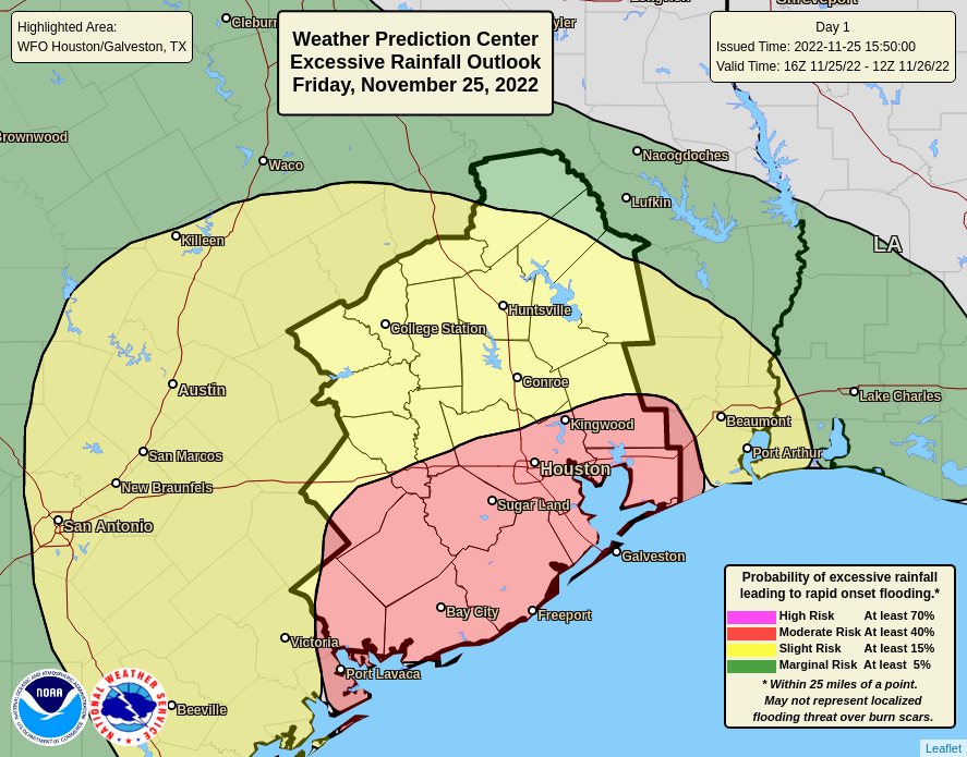
The southern half of the Houston metro area has a “moderate” risk of excessive rainfall tonight. (NOAA)
Late Friday night/early Saturday morning
Overnight a slow-moving low pressure system should combine with ample atmospheric moisture to produce heavier rainfall. Sometime after midnight, therefore, we expect strong, widepsread storms to move into the Houston region and generate rainfall rates as high as 2 inches per hour. These rates are intense enough to quickly back up roads, and therefore we expect that some areas will see street flooding late tonight into Saturday morning. While we cannot entirely rule out a touch of severe weather, such as damaging winds for the most part these should be be heavy showers with some lightning mixed in.
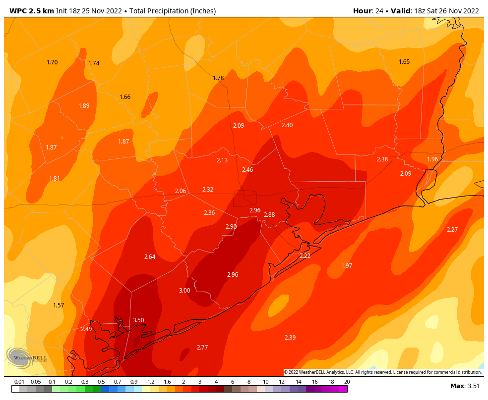
At some point these showers will clear out from west to east on Saturday morning. Most model guidance suggests the heavy rain should depart by 7 to 9 am, with showers ending entirely by around noon. Between now and then I expect most areas to receive 2 to 4 inches of additional rainfall, with the potential for higher totals in isolated areas. The further north of Interstate 10 you live, the more likely you are to see lower accumulations.
NOAA rain accumulation forecast for now through Saturday morning. (Weather Bell)
Saturday afternoon and beyond
Skies should clear pretty quickly as the rain showers move out, so I expect partly to mostly sunny skies by Saturday afternoon, with highs of around 70 degrees. Lows on Saturday night will drop to around 50 in Houston, which means colder conditions further inland. Sunday looks splendid, with sunny skies and highs of around 70 degrees. Monday will be similar before we start to warm up ahead of a mid-week cool front.
Unless the forecast takes a turn for the worse, this will be our last update until Saturday morning, at which time we expect to drop the Stage 1 flood alert.
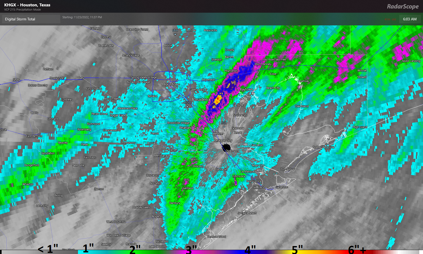
Thanksgiving’s rains were very impressive. In fact, for Hobby Airport it was a new Thanksgiving record, with 1.53″ of rain, breaking last year’s 0.59″ (set on Nov 25 last year) for wettest Thanksgiving since records began in 1930. But it was areas just east of Hobby Airport that really took home the stuffing.
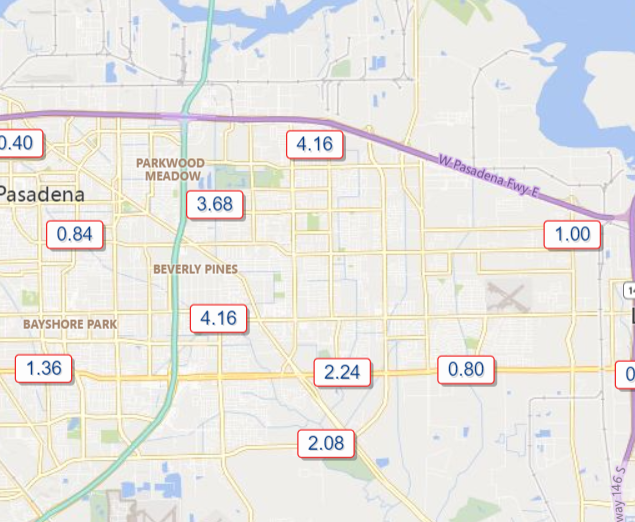
Most areas around Houston saw an inch or so of rain, but a corridor from near Alvin and Friendswood through Mont Belvieu into Liberty County saw 3 to 7 inches of rain on Thanksgiving, a record for wettest Thanksgiving on record in some spots. (RadarScope)
A narrow band between about Friendswood through just west of Mont Belvieu saw anywhere from 3 to 7 inches of rainfall, with the bullseye right over Deer Park. In addition, you may have heard about the tornado warning in Brazoria County. Thus far no confirmed tornado reports have been noted, but things definitely got dicey for a few minutes yesterday afternoon. The severe threat is not zero today, but it’s relatively low and confined to areas well south of Houston.
Housekeeping/Fundraiser
I just want to open today with a little housekeeping. First, with active weather back in the area for the first time in awhile, we encourage you to download our app for your iPhone or Android device. Likewise, if you or someone you know prefers weather updates in Spanish, Maria Sotolongo does exactly that for you at our companion site Tiempo Ciudad Espacial! Maria truly does outstanding work, so please check it out and share it with any of your friends or family like weather updates written in Spanish. Maria also curates our Facebook, Instagram, and Twitter feeds for TCE, so you can follow those as well.
Related to that, our annual fundraiser is down to the wire now! There are just a few days left for you to truly help make a difference for our site. Your contributions directly help fund our work, app improvements, and tricks up our sleeve for the future. You can click here to buy items to rep the site. And if you don’t wish to purchase merchandise and just want make a contribution, click here and check the box that says “I’d like to make a donation only.” We are grateful for any and all support. Thank you!
Today
Onto the weather. A little housekeeping here too: A Flood Watch remains in effect until tomorrow morning, and Eric and I will maintain our Stage 1 Flood Alert until then as well. We continue to expect primarily street flooding to be the issue with further rains, but we also do want to monitor the area around Armand Bayou through the Clear Creek watershed given yesterday’s exceptional rains there.
The frustrating reality today is that we do not expect a washout, but there will be a chance of rain and scattered showers or downpours around virtually all day. The morning looks mostly fine, but rain showers will become more frequent this afternoon and evening. The bottom line today: Have an umbrella and a backup plan in case you’re chased indoors for a time. Temperatures look relatively stable, in the 50s and 60s, gradually warming through the day.
Later today through Saturday morning
It’s encouraging that we have a little bit of a break today because we are likely to get smacked with another round of heavy rain and storms this evening into Saturday morning. Expect periods of showers and storms to become more numerous from late afternoon and evening, culminating in what should be a pretty solid line of storms toward sunrise on Saturday. Some strong storms with gusty winds are possible in addition to heavy rainfall.
Another 1 to 3 inches of rain is expected between now and Saturday morning, with isolated higher totals that could lead to street flooding again in parts of the area. (Pivotal Weather)
We expect roughly 1 to 3 inches of additional rainfall between now and tomorrow morning, most of which will fall in roughly a 6 hour window overnight or early Saturday. Isolated higher amounts are absolutely possible. The heaviest rain seems likely to fall near where the heaviest rain fell on Thanksgiving Day, which is to say in Houston and points south and east. Street flooding will again be possible tonight and early Saturday.
Temperatures will remain stable, in the 60s.
Rest of Saturday
If you have outdoor plans Saturday, you have a mixed bag. The morning will be dicey due to lingering showers and storms, but the afternoon looks great. Rain should end from west to east between about 7 and 10 AM on Saturday. Skies should begin to clear and temperatures will bounce around a bit within the 60s with lower humidity. We should cool a bit toward the 50s by late afternoon.
Sunday and beyond
Sunday will live up to its name with sunshine. Morning lows will start in the 40s to near 50 and warm by afternoon well into the 60s. We will essentially repeat this on Monday.
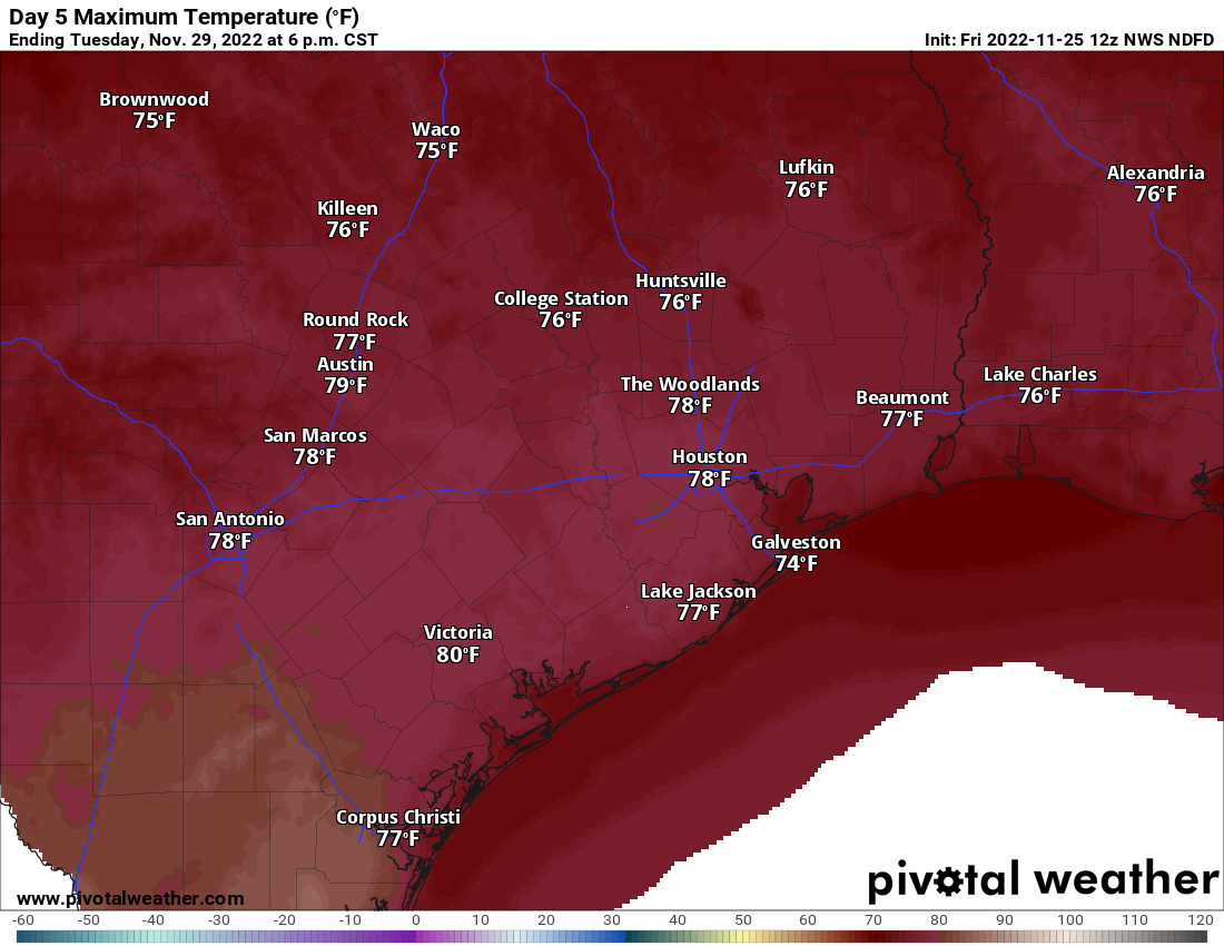
If you seek a respite from the cool temperatures of late, you can look forward to Tuesday when we could hit 80 degrees in Houston. (Pivotal Weather)
For Tuesday, clouds and temperatures will increase. We have an outside shot at 80 degrees Tuesday afternoon with enough sunshine. Our last 80 degree day was on November 11th. A few showers will be possible. Humidity will also surge higher. Our next front should arrive Wednesday into Thursday knocking us back into the 40s for lows. Another fairly quick warm up seems likely for next weekend, but additional shots of cool to cold air may not be far behind. A little something for everyone.
Eric will have an update later this afternoon to set us up for tonight’s storminess.
Good afternoon. Round one of rainfall this morning was mostly uneventful, with the notable exception of the Deer Park area, which received over 4 inches of rain, much of which fell in an hour or so.
Rain totals over 4″ in the Deer Park area caused some substantial street flooding in spots. More rain is to come, and Armand Bayou in particular will be running fairly high. (Harris County Flood Control)
Armand Bayou is the one bayou worth watching closest as we head into this evening. It is running near bankfull after the earlier rains, and we could see some portions of the bayou come out of banks with round 2 in a couple hours. Please stay vigilant in that area.
We remain in a Stage 1 Flood Alert, as Eric has noted, and the NWS has just issued a Flood Watch for the entire metro area through Saturday in anticipation of several more rounds of rainfall.
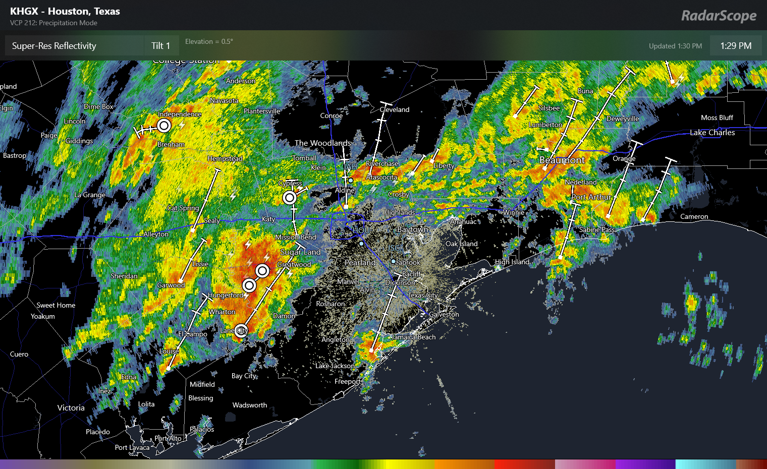
That next round is on the way as of 1:30 PM.
A cluster of very heavy rain southwest of Sugar Land will overspread most of the Houston area through mid-afternoon, with 1-3″ of additional rainfall possible where it rains hardest. (RadarScope)
This cluster of rain will produce thunder, lightning, some gusty winds, and very heavy downpours. Additional rains of 1 to 3 inches are possible as this band passes through between now and 4 or 5 PM this evening. Please use caution if you have to travel between now and then, and if you can postpone travel a couple hours to avoid the worst of the rain, that may be prudent. Street flooding is likely in spots, hence our stage 1 alert. And as noted above, we’ll be monitoring the Armand Bayou watershed in particular for any worse issues. We are hopeful that the heaviest of this rain will pass north of the harder hit areas in Deer Park this morning.
The good news is that things do settle down a bit tonight. Additional scattered showers and storms are likely once this wave passes through, and those will continue through about Midnight, but the intensity and coverage should be less than this afternoon. Overnight looks quiet with just some scattered showers possible.
Additional showers and storms are likely tomorrow and especially in the first half of Saturday. We’ll update on those once we get today’s platter digested.
A reminder: We offer our posts in Spanish at Tiempo Ciudad Espacial! If you yourself prefer reading in Spanish or have friends and family that would enjoy our site more in Spanish, please spread the word! As always, a thank you to Maria Sotolongo for always being on top of things for that site.
Fundraiser
As I sit here writing this on Thanksgiving Day, I am reminded of how thankful I am for our readers. We know you feel likewise about us, and for your trust, support, and loyalty, we are grateful! If you would like to support us in our annual fundraiser, it will continue through this weekend. You can click here to buy items. And if you don’t wish to purchase merchandise and just want make a contribution, click here and check the box that says “I’d like to make a donation only.”
Eric or myself will have another update tonight if necessary, and certainly by tomorrow morning. Thank you, and have a safe Thanksgiving.
Good morning. I hope this message finds you happy and healthy on this Thanksgiving morning. I have much to be thankful for in both my personal and professional life. One of the things I am most happy about is the trust placed by readers in the work Matt and I do. So thank you for spending a few moments with Space City Weather on this holiday morning.
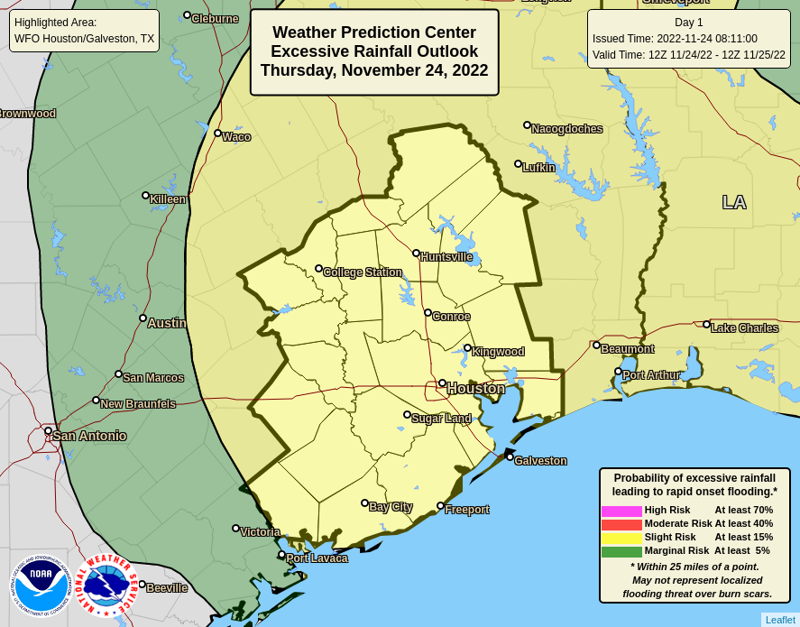
This morning’s forecast will focus the forthcoming rain event that will bring two days of showers and thunderstorms to the Houston region. While most of this rainfall will be manageable—most locations should receive 1 to 4 inches—we’re concerned about more isolated areas that could receive up to 6 inches of precipitation between now and Saturday morning. This may cause street flooding, and therefore we have called for a Stage 1 flood alert.
Chance of “excessive” rainfall for Thursday and Thursday night. (NOAA)
Thursday
As anticipated, we are seeing the development of storms near the coast this morning, in the Freeport and Lake Jackson area. These storms are associated with a warm front moving in from the Gulf of Mexico, and will become more widespread leater this morning. This front should progress toward Interstate 10 by around noon, and it is likely that the strongest storms this afternoon will lie to its north. Therefore, today, we are most concerned about rain accumulations along and north of Interstate 10. Highs today will reach about 70 degrees, give or take, with cloudy skies and muggy air. I expect that showers will back off this evening and during the overnight hours, while the atmosphere recharges.
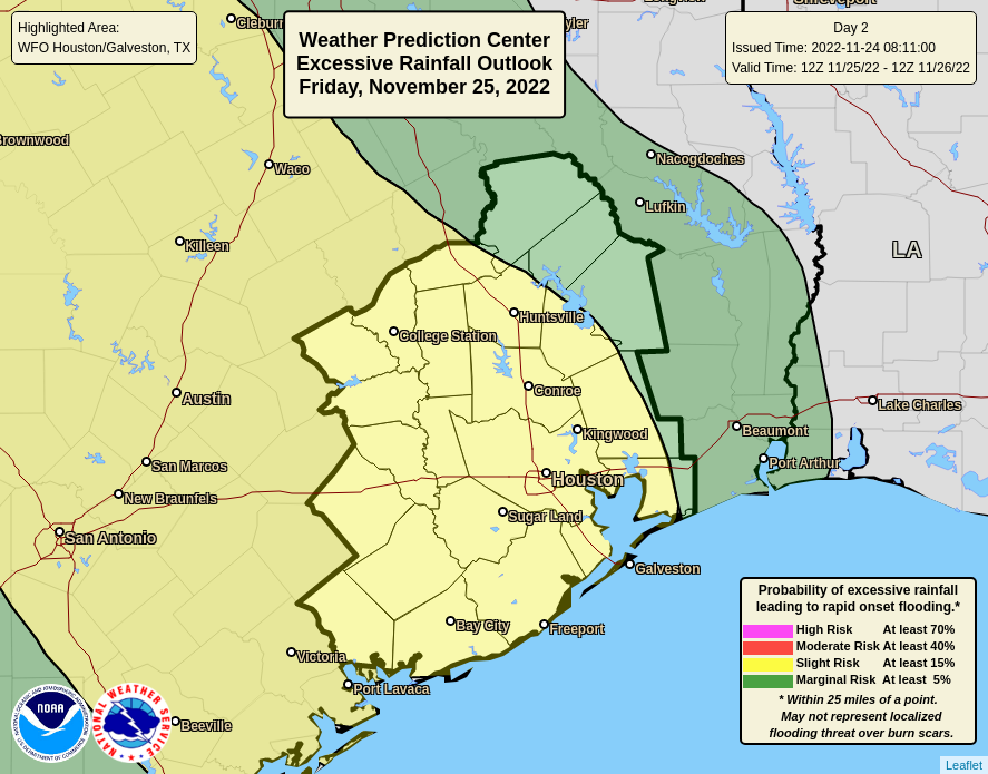
Chance of “excessive” rainfall for Friday and Friday night. (NOAA)
Friday
Conditions will continue to favor widespread showers and thunderstorms as a cut-off low pressure system lifts moist air at the surface. At this time our higher resolution models are suggesting that storms on Friday will peak during the afternoon, evening, and overnight hours. Over the last couple of days the overall movement of this low pressure system has slowed down, so it’s entirely possible the heavy rainfall threat will extend into Saturday morning. That’s something we’ll be watching for. Highs on Friday will be in the mid-60s.
Saturday and Sunday
We’re still expecting things to clear out significantly this weekend, but there’s now the potential for some lingering storms on Saturday morning. Skies should become partly sunny during the afternoon, with highs in the mid-60s. We’ll be sunny, with a high near 70 on Sunday. Expect this warming trend to continue until Tuesday or Wednesday, when the next front arrives.
As we continue to track this dynamic rainfall situation, Matt will have an update for you this afternoon.