A slow—emphasis on slow—warming trend begins today, lasting through the holiday period

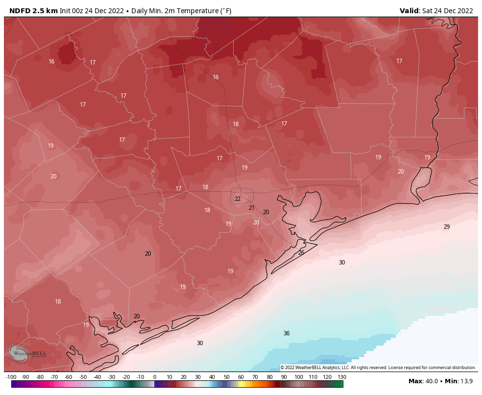
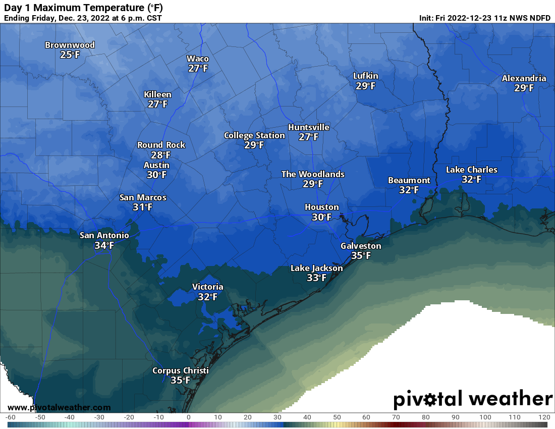
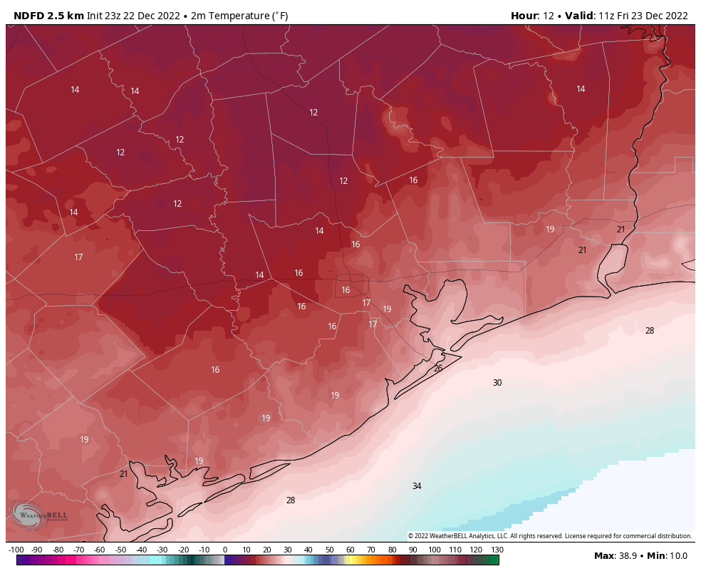
Good morning. Much of Houston has once again sunk into the upper teens this morning, as a hard freeze grips the region. However, this will be the worst of it, with Houston seeing one more night in the 20s heading into Christmas morning. Next week looks considerably warmer.

Christmas Eve

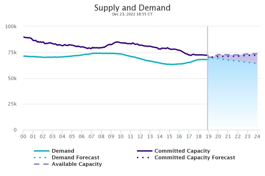
Skies will be mostly sunny today, and if you live south of Interstate 10, highs may eventually climb to 40 degrees or higher. Further inland you’ll probably remain in the upper 30s. A noticeable, and welcome, change today will be much reduced winds out of the north at 5 to 10 mph. Clear skies tonight will allow temperatures to drop into the mid-20s in the city of Houston, with colder conditions further inland. In terms of electricity, the state power grid seems to be holding steady. We expect that to continue.

Low temperature forecast for Christmas morning in Houston. (Weather Bell)

Christmas Day

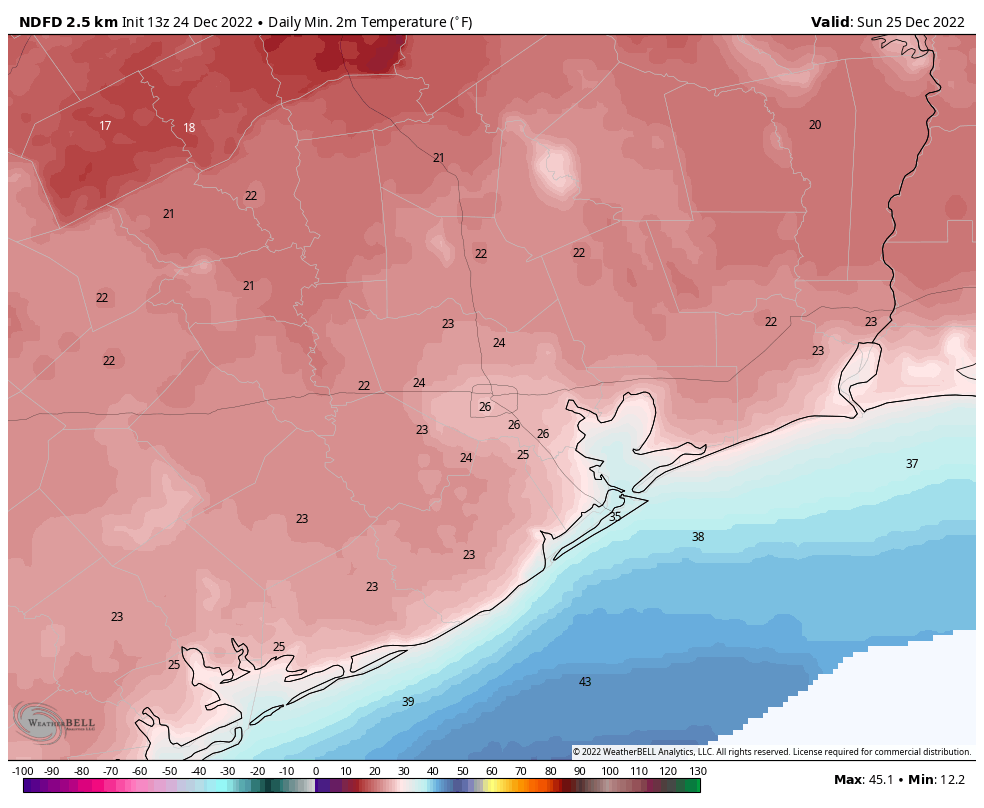
Don’t tell my niece, but she’s getting a trampoline for Christmas. While it will still be cold on Sunday, with highs in the mid-40s it will certainly feel warmer than recent days. So if you dress warmly, with the sunshine and just a light wind, conditions should be fine for outdoor activities such as trampoline jumping after the early morning chill burns away. Overnight lows on Sunday night will get down to about freezing in Houston, with colder conditions inland, and more moderate ones along the coast.

Monday and Tuesday

A bit of uncertainty remains about whether a reinforcing front pushes into Houston on Monday night, or washes out, but I don’t think it matters in terms of precipitation. Both of these should be mostly sunny days, probably with highs slotting into the 50s. Monday nights lows may drop into the 30s, but Tuesday night will be warmer.

Wednesday

This has the look of a pleasant, partly sunny day with highs in the 70s.

Thursday and Friday

The pattern turns more unsettled by the end of the week as high pressure shifts eastward, and we’re opened up to a warmer, more humid flow from the Gulf of Mexico. This will bring a notable increase in rain chances. Accordingly I expect both of these days to be mostly cloudy, with at least a 50 percent chance of rain, and highs in the 70s.

A very early look at a rain accumulation forecast for now through Friday, Jan. 30. (Weather Bell)

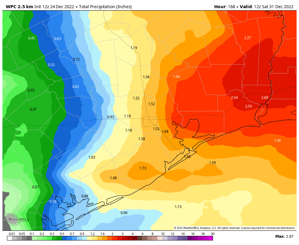
New Year’s Eve and New Year’s Day

The forecast is fairly muddled by this point, but my general expectation is that some kind of weak front is going to push into the region on New Year’s Eve, or thereabouts. This probably will bring an end to the rain showers before festivities start later on New Year’s Eve, but at this point out it’s too far away to say that with any confidence whatsoever. The front may sap some of the humidity, as well. My bet for highs on New Year’s Day would be about 70 degrees, but again, it’s a long ways off.

Best wishes for a Merry Christmas and Happy Holiday season

This will be our last post until Tuesday, December 27. It has been a long week due to the cold weather, and with relatively calm conditions ahead we’re going to take a couple of days off to celebrate the holiday weekend. So for Matt, Maria, Lee, Dwight, Hussain and everyone else who contributes here at Space City Weather, let me wish you joy on Christmas Day and during the rest of this holiday season. Your trust is the greatest gift we can receive.

As the region faces another cold night, energy companies ask Texans to conserve power right now

Hi everyone. Just a quick update this evening to set the table for a very cold night, and to provide what limited information we can on the state’s power situation. The bottom line is that lows tonight will drop to around 20 degrees in the city of Houston, with colder weather in outlying areas, and as temperatures plummet we are likely to see a strain on the state’s power grid. Please conserve energy during the next few hours.

Friday night

With lighter winds tonight, lows probably will be 2 to 5 degrees above the extremely cold conditions observed on Friday morning. However, with winds gusting up to 15 mph the apparent temperatures will be in the single digits again. This is weather unfit for people or pets, so please take precautions, as well as keeping in effect your cold-weather plans for pipes. We’ll warm up a little bit more on Saturday morning, with area highs reaching about 40 degrees. There will be less wind, as well, which certainly will be a welcome change.

NOAA forecast low temperatures for Friday morning. (Weather Bell)

Energy conservation

Matt and I have been watching the ERCOT supply and demand tracker all day, and it seems that the agency’s estimates for power demand have been consistently low. Understanding the ins and outs of this predictive tool are beyond the scope of a meteorology site, but the Texas Tribune has a helpful story on the issue. The bottom line is that, as of 7 pm CT, ERCOT predicts that it will have enough energy capacity to meet demands tonight. But things are going to be cut really close from now until 10 pm or so.

Power supply and demand forecast for now through midnight CT. (ERCOT)

To that end, some energy companies have been asking residents and businesses to conserve energy usage tonight. In an email to its electricity customers, Reliant asked for conservation through at least 10 pm CT by taking the following steps: 1) If you have an electric heater, set your thermostat 1 to 2 degrees lower and run ceiling fans clockwise; 2) Roll up towels or blankets and put them under drafty doors and window sills in your home; 3) Hold off on running your dishwasher, washer and dryer.

CenterPoint, which provides natural gas in the Houston region, is also calling for conservation. In particular, the company asked for people to turn off pool heaters: “We encourage customers to be especially mindful of their pool heater usage. One pool heater uses as much natural gas as 4 residential homes. Customers can keep their pumps on without the heater to prevent their pool water from freezing.”

To be clear: We do not anticipate widespread, extended blackouts tonight or tomorrow like the state experienced in 2021. Warming on Saturday should really help things out. However there may be issues this evening, and any steps you can take would help.

I’ll be back with a final forecast post on Saturday morning ahead of the Christmas holiday. Be well tonight, friends.

The weather outside is quite frightful this morning in Houston

Okay, campers, rise and shine, and don’t forget your booties ’cause it’s cooooold out there today! Unlike 1993’s “Groundhog Day,” this will soon be a distant memory as we warm up heading into next week. But in the meantime, it is our coldest morning since February of 2021. Houston has so far bottomed out at 16°, and the coldest reading I can find as of 6:30 AM is 10° up in New Waverly. I also saw an 11 just outside Tomball. Whatever the case, it’s about 10 to 20 degrees in most places this morning, and it’s cold.

Our coldest morning since February 2021 with temperatures as cold as 10° north of the Houston area, around 13°-19° in most suburbs and much of the city, and near 20° south. (NOAA)

The wind isn’t helping. We continue to see wind gusts up as high as 33 mph in Houston at Hobby Airport and 39 mph in Galveston. The combination of wind and cold makes it feel about as brutal as it can realistically get here in Houston. Wind chills are currently 5° in Galveston, 3° at Bush Airport, 1° at Hobby Airport, and -4° in Conroe.

Anywhere you see white on the map above, wind chills are below zero this morning. Even the warmest locations in the area are seeing wind chills as low as 5 degrees. (Weather Bell)

So before you go out and do that last minute Christmas shopping, please make sure you are adequately dressed. This type of cold can be dangerous, especially for those of us in Texas that are simply not used to temperatures at these levels.

The good news is that roads should be all clear and passable, as we saw no ice or snow with the front yesterday. Travel anywhere across Texas is fine today. If you are flying, please go with a lot of patience. Flights to Chicago are likely to be delayed. Milwaukee’s airport is currently closed. All of these issues will cascade through the system, so flight delays and cancellations are possible anywhere.

Some good news is that ERCOT is in fine shape this morning. As of this writing, Texans are using about 73,000 megawatts (MW) of electricity, and the grid has nearly 85,000 MW available. According to their site, things do get a little tighter looking this evening, as wind falls off versus where it was last night and this morning. As of now, we don’t foresee any serious issues, but given that they failed to forecast the amplitude of the energy demand last night and this morning (they missed by several thousand megawatts), it is worth monitoring later today.

Centerpoint is reporting just shy of 20,000 customers without power this morning. This is due to localized outages from tree branches or power lines being impacted by the strong winds in our area. That number should improve through the day as winds ease up.

Friday

The good news is that the sun will help make it feel just a little less uncomfortable today. Still, expect high temperatures barely scraping 30 degrees in most places. The freeze continues.

High temperatures this afternoon will limp to near 30 degrees, despite the sun. (Pivotal Weather)

Winds will remain blustery today, with gusts of 20 mph inland and 30 mph at the coast. So wind chills will remain a factor all day today as well.

Tonight & Saturday

Most of our attention has been focused on this morning’s temperatures because they were to be the coldest of this event. But tonight will be pretty rough as well. Thankfully, we will see less wind, but we will still likely have a hard freeze almost everywhere, so keep all protective measures for pipes, plants, people, pets, and livestock in place. Some passing cloud cover may prevent temperatures from dropping as far as they did last night and this morning, but it will still be plenty cold.

Overnight lows tonight into Christmas Eve morning will be about 3 to 5 degrees warmer than this morning, give or take. Still, this will lead to another hard freeze in much of the area. (Pivotal Weather)

Saturday should end up being a slightly nicer day. Expect only a light breeze, more sunshine, and temperatures warming above freezing and deep into the 30s.

Sunday & Monday

Christmas Day will be another chilly one, but we’ll be gradually eating away at the cold. Only outlying areas really have a risk for a significant hard freeze Sunday morning, while most of Houston proper, coastal areas, and some of the denser suburbs will probably “only” get to the mid-20s overnight. We’ll turn things up into the 40s on Christmas afternoon.

We may get a weak reinforcing front on Monday. Still, we’ll likely get above 50 degrees Monday afternoon. We’ll have another chilly night Monday night into Tuesday with 30s in most spots and perhaps a few high 20s in outlying areas.

Rest of next week

Tuesday will see highs in the 50s or low-60s, Wednesday in the 60s or low-70s, and Thursday into the 70s. In fact, we’ll probably see highs in the 60s and 70s and lows in the 50s or 60s straight through New Years weekend. The weather may turn more unsettled late next week as well, but details on that are minimal this far out. We’ll tackle that next week.

Arctic air now moving into the Houston area, expect very low temperatures tonight

The long-advertised front has arrived, bringing a sharp dose if frigid air diving down from the Arctic Circle. Wind gusts this afternoon have exceeded 40 mph at multiple locations this afternoon, including a top speed of 48 mph at Hobby Airport. As of 5:30 pm CT, air temperatures remain just above freezing in the Houston metro area, but that will not last long as the mercury starts to drop tonight.

Cooldown

Houston is headed into the icebox for a solid 36 hours. Lows tonight will likely fall into the mid- to upper-teens for all the metro area, aside from the immediate coast, which may hold at 20 degrees or slightly above. Even will full sunshine on Friday, high temperatures may only briefly reach 32 degrees during the afternoon, whereas areas further inland may only top out at about 30 degrees. Conditions will be very cold again on Friday night, with lows perhaps only 2 to 5 degrees warmer than Thursday night. By Saturday, finally, the area should see highs of around 40 degrees.

Reasonable “worst case” scenario for low temperatures on Friday morning. (Weather Bell)

The good news is that there is no snow or ice on roadways, so aside from blustery conditions it is safe to drive throughout the greater Houston area and beyond. Roads will remain dry through Christmas Day and beyond.

Power

One of the major problems during the February 2021 freeze was the lack of power, when “rolling” blackouts became permanent due to poor management of the Texas electricity grid and a lack of oversight for proper winterization of power plants. It does appear this problem has been solved. ERCOT is reporting excess power generating capacity, and expects to have electricity to meet demands overnight as temperatures plummet across the state. You can track supply and demand in real time here.

Next post

Matt will have a comprehensive update for you by around 6:30 am CT on Friday. Until such time, please stay warm, make sure your pets and neighbors have the shelter they need, and take care of one another. It is the holiday season, after all!