Splash and dash showers briefly return to the forecast this weekend

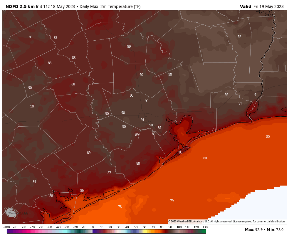
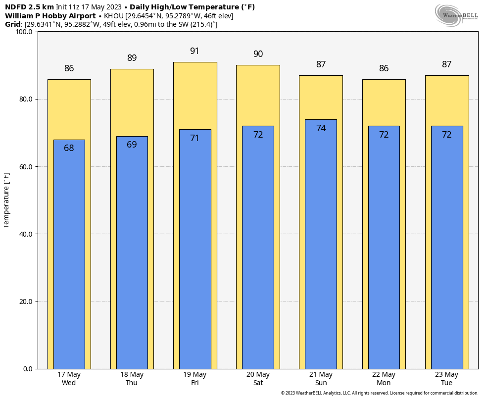
We eked out a 90 degree day on Thursday, and we’ll look to do it again today, as early summer starts to assert itself. That said, the humidity will remain fairly tame over most of the next several days, especially away from the immediate coast. All in all, about par for the course for late May.

Today

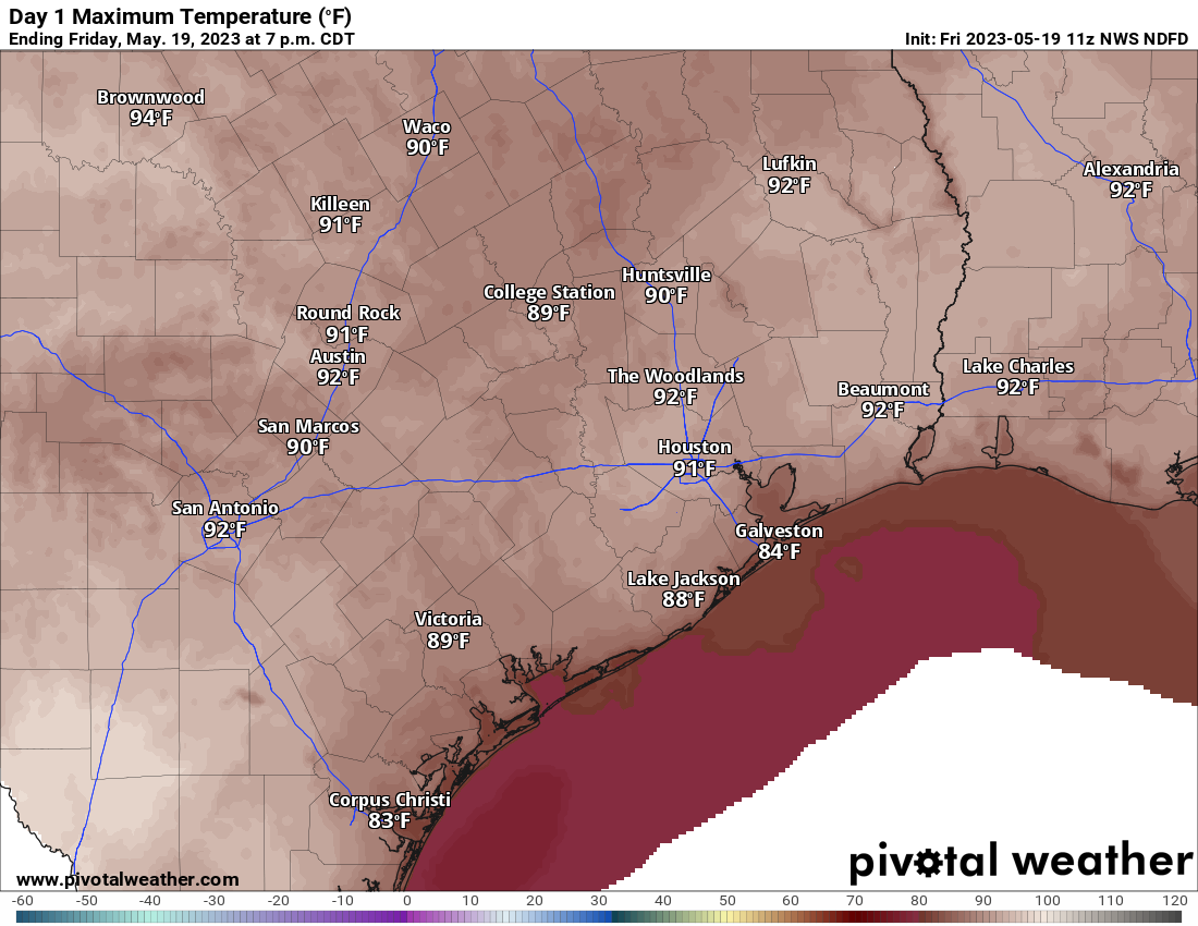
We’ll have plenty of sunshine today. Look for high levels of ozone as a result, so air quality may be a bit poor this afternoon, especially for those of you that are in a sensitive group for ozone. High temps should approach or exceed 90 degrees in many spots away from the coast.

High temperatures will range from the mid-80s in Galveston to the low-90s in and around Houston today. (Pivotal Weather)

Weekend

The weekend will feature the much discussed “cool” front that should help keep the humidity in check a little longer. Of course, that does mean the return of shower chances. On Saturday, with the front sneaking into our northern areas in the morning, some showers and storms may pop up as early as the early morning. We’d likely see those dissipate rather quickly and then some new isolated showers or storms develop in the afternoon or evening elsewhere in the region. We’d anticipate that most areas won’t see anything too crazy Saturday. A few communities will see a downpour, however.

Hit and miss showers may continue after sunset Saturday and into Saturday night, especially west of the Houston area, probably closer to San Antonio. Again, nothing major is expected, but if you have outdoor plans, maybe have an umbrella at the ready just to be safe.

As the front kind of washes itself out overhead on Sunday, we should see scattered storms across the area, focused in Houston or possibly points south. While we again don’t expect any significant issues, there could very well be a couple downpours in the area Sunday. The slight edge for outdoor plans goes to Saturday this weekend over Sunday. We aren’t expecting any big ticket totals, but a couple areas may see up to an half-inch or so of rain, while others see nothing at all. I’m keeping my expectations rather in check this weekend based on the latest data, but as always, prepare just in case a few showers or storms pop.

As far as temperatures go, we foresee upper-80s to low-90s Saturday and slightly cooler temps Sunday (low-80s) due to clouds and some of those possible showers. Morning lows should be around 70 degrees.

Early next week

Once we get to Monday, most of the impetus for driving showers and storms will have vanished. That being said, with some clouds and a good bit of sun, we could still see some showers or isolated storms, mainly south and southwest of Houston.

Borderline pleasant morning lows will greet you on Monday morning, with 60s away from the coast. (Pivotal Weather)

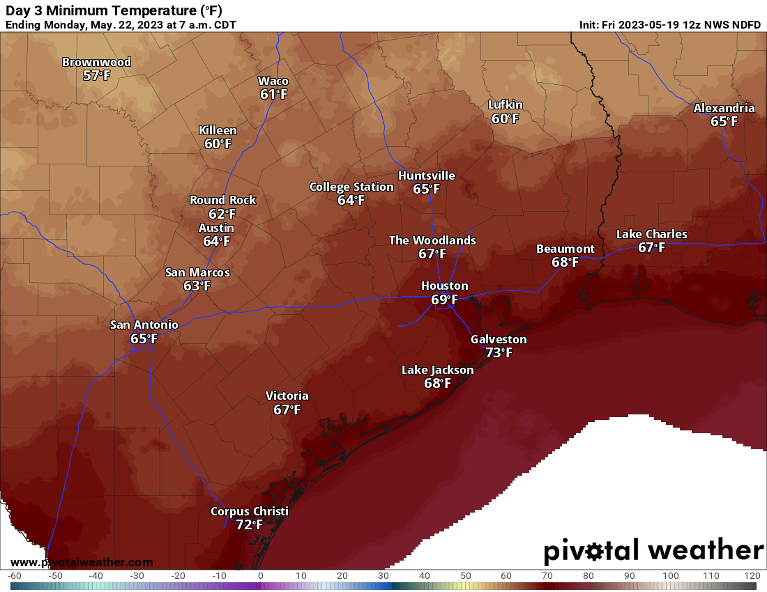
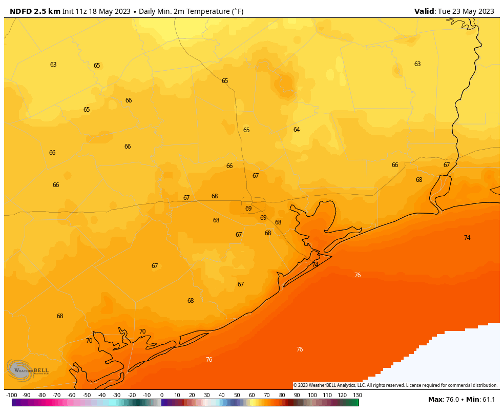
With the slight drop in humidity in the wake of the front, we will probably see lows mostly in the 60s to start next week. Daytime highs will still be plenty warm, with mid to upper-80s Monday and Tuesday. Tuesday’s rain chances should again be mostly focused south and west of Houston and on the lower side in general.

Later next week

I think Wednesday and Thursday carry greater coverage of showers and storms than we see Monday or Tuesday and closer to Houston proper. These storms would likely come from the east in Louisiana and be capable of some heavier downpours, thanks to a weak “backdoor” cold front. Temperatures may hold in the mid-80s here. We might get a very slight reinforcing shot of drier air behind that front to keep humidity levels in check another couple days into the weekend. But thereafter, summer should begin to flex, with warmer nighttimes (low to mid-70s) and daytime highs at or above 90° daily by the end of Memorial Day Weekend.

It’s a bit early to speculate much on the holiday weekend, but as of right now there is nothing that stands out in terms of higher rain chances or extreme temperatures. We’ll check back in on that next week.

Spring’s last gasp likely comes this weekend with a weak front

Good morning. We are now in the second half of May, a period I like to call “early summer,” when we first start to see 90-degree temperatures with some regularity, but some nights in the 60s are still possible, and there’s still the thinnest hope of a weak front. That weak front is coming Saturday, and it will bring us a few days with slightly drier air. After that? Well, we’ll be at the end of the month with June right around the corner.

Surely you know what that means?

Thursday

Today will be sunny and warm, with high temperatures around 90 degrees. Winds will be light and variable. Lows tonight will drop to around 70 degrees.

Friday’s high temperatures will reach 90 degrees for much of the area. (Weather Bell)

Friday

Did you like Thursday? Good, because Friday and Friday night will be pretty much the same, with only a slight uptick in winds, now coming from the south.

Saturday

A weak front should cross the region on Saturday afternoon and evening. There is not going to be a whole lot of instability for the front to work with, so at this point I’d peg the chances of a shower or thunderstorm at any given location in Houston at about 20 percent during the daytime or evening. Highs will reach about 90 degrees, with partly to mostly cloudy skies.

Sunday

Clouds will linger for much of Sunday, but highs will be slightly cooler in the wake of the front, with highs in the mid-80s. That back-burner, 20 percent chance of rain will linger throughout the day before things clear out Sunday night. Lows should drop into the upper 60s.

Lows next Tuesday morning will be in the 60s for most of the area. For the last time? (Weather Bell)

Next week

The first two or three days should see highs in the upper 80s and lows in the upper 60s, with partly sunny skies. The air is not going to be dry, but with dewpoints in the low- to mid-60s, this is going to be as dry as it gets for about four months. Temperatures warm to about 90 degrees with muggier air during the second half of the week. In terms of rainfall, it doesn’t look like there will be much.

After days of storms, the spigot shuts off and sunshine will mostly prevail

If you’re tired of the rain, have I got good news for you. It’s pretty much over for awhile, with a lot of sunny days ahead. Our weather will now enter a much calmer pattern for at least the next week or 10 days. It’s a bit of a siesta for local meteorologists before the Atlantic hurricane season begins in a couple of weeks. I’ll happily take it.

Wednesday

Temperatures have fallen into the upper 60s across much of the metro area this morning in the wake of a weak front. This pattern change will effectively shut down rain chances for awhile, although there is perhaps a 10 percent chance of an isolated shower or storm near the coast this afternoon. Otherwise expect partly to mostly sunny skies with highs in the mid- to upper 80s today with light northwesterly winds. Lows tonight will drop into the upper 60s again.

Most of the region will see another night in the upper 60s early on Thursday. (Weather Bell)

Thursday

Expect sunny skies and high temperatures near 90 degrees. Winds will be very light, turning southerly later during the day. Lows on Thursday night will drop down to around 70 degrees, or perhaps a bit lower for inland areas.

Friday

Another sunny and warm day, with high temperatures around 90 degrees or a bit higher. Lows on Friday night will drop to around 70 degrees, or a bit lower.

Saturday and Sunday

Partly to perhaps mostly cloudy skies on Saturday will likely limit temperatures to about 90 degrees. Another weak front arrives sometimes during the daytime on Saturday, and this instability will bring a 20 percent chance of rain into the forecast on Saturday and Sunday, but most of us should remain dry. Sunday should be a bit cooler, with highs in the mid-80s. Lows on both nights this weekend will reach about 70 degrees.

Late May will feel pretty much like late May in Houston. (Weather Bell)

Next week

Monday and Tuesday look to be partly to mostly sunny days with highs in the mid-80s. Our air is not going to be dry, per se, but with dewpoints in the 60s it’s not going to feel exactly Houston humid, either. That is coming with June around the corner, fret not. By the later part of next week we should see highs returning to near 90 degrees. As of now, there appears to be no significant outbreak of showers and thunderstorms next week.

Storms possible today mostly south of I-10, after which two weak fronts bring nice weather for late May

Good morning. After a week or so of wetter and cooler weather, Houston’s pattern will transition to drier and mostly sunny conditions for awhile. We’re also going to see a couple of weak fronts that will bring us slightly less humid conditions for awhile. That is about all you can ask for during the second half of May.

Tuesday

There will be one last chance of showers and thunderstorms this afternoon and early evening, as our atmosphere remains moist, and somewhat fertile for storm activity. The favored area today will be south of Interstate 10, from Galveston Bay to Matagorda Bay. Isolated areas may say 0.5 to 1.5 inch of rain. Rain chances will be lesser, perhaps 30 percent, for areas north of Interstate 10. Skies will be partly to mostly cloudy, with highs in the mid-80s for most. Storms should end this evening, with the loss of daytime heating. Lows tonight will drop to around 70 degrees.

NOAA rain accumulation forecast for Tuesday and Tuesday night. (Weather Bell)

Wednesday

A weak front arrives on Tuesday night, and this should usher in slightly drier air at the surface, and knock a lot of the moisture out of the atmosphere above. Put another way, we’re going to shift from a rainy pattern to a dry one rather abruptly in terms of precipitation. Look for partly sunny skies and highs in the mid-80s. Winds will be out of the northwest at 5 to 10 mph. Lows on Wednesday night will drop into the mid- to upper 60s for much of the region, which is rather pleasant for the second half of May.

Thursday and Friday

These will be a pair of warm days, with highs of around 90 degrees, and sunny skies. Nighttime lows will drop to around 70 degrees.

Low temperature forecast for Thursday morning. (Weather Bell)

Saturday and Sunday

My confidence is increasing that a second front will, in fact, push all the way off the coast. Saturday is likely to be warm and sunny ahead of the front, with highs near 90 degrees. There will be a slight chance of showers and thunderstorms during the afternoon and evening, along with the front’s passage, with clouds building overnight. Lows likely drop to around 70 degrees. On Sunday we’ll probably see mostly cloudy skies, with highs in the mid-80s.

Next week

The first half of next week should see a mix of sunshine and clouds, with daytime highs in the mid-80s. Dewpoints will drop into the mid-60s, which is going to feel slightly more comfortable than typical dewpoints in Houston. The bottom line is that this is probably spring’s last gasp. It’s not going to be much, but it’s also a world of difference from highs in the 90s and sultry, summertime humidity.