Calm end to the week for the Houston area, with our next front en route before Thanksgiving

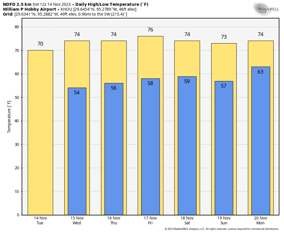
After starting off nice yesterday, clouds did creep back for the afternoon. Most of that has cleared or is off to our east now. But we’ll fight the cloud cover forecast a bit again today. Hey, if clouds are the hardest part of our forecast, we’ll take that.

Meanwhile, just a quick reminder that our annual fundraiser is ongoing. We have a merch shop open for a limited time, or if you just want to donate to the site, you can do that too. We sincerely appreciate all the support!

Today

Clouds are going to linger this morning east of Chambers County, especially in the Beaumont-Port Arthur area. These are stubborn low clouds that are a little more difficult to eradicate in mid-November, but hopefully some sunny breaks can emerge in those areas today.

Satellite image from about 6:30 AM showing low clouds east of the Houston area and clear skies over most of the region. (College of DuPage)

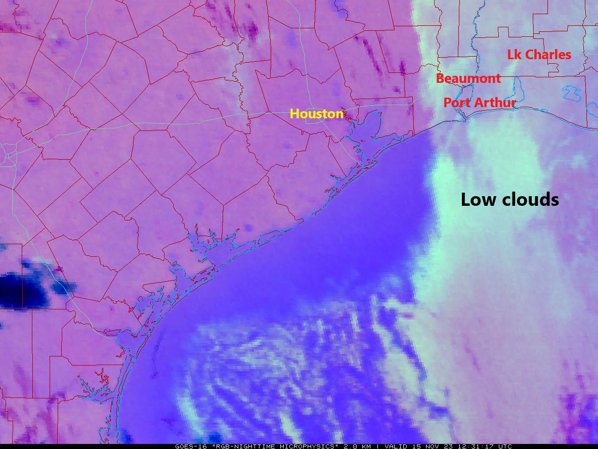
Some model guidance does nudge those clouds back west a bit, so places like Baytown or Mont Belvieu run the risk of seeing some clouds perhaps for a time later today. But overall, let’s call today mainly sunny with highs in the low-70s.

Thursday & Friday

Both days look partly to mostly sunny and calm. We should see warming conditions with highs in the mid-70s tomorrow and upper-70s perhaps on Friday. Morning lows stay in the 50s. There could be a little patchy fog on either morning, but that should lift rather quickly after sunrise.

Saturday

A weak “cool” front will swing through late Friday or early Saturday. You probably won’t notice it at all, but it will act to sort of reinforce this autumn air mass a bit. We’ll top off in the mid-70s, with morning lows again in the 50s. Expect a mix of sun and clouds.

Sunday & Monday

Clouds increase on Sunday, and we should see at least some scattered showers return to the picture by later in the afternoon or evening. Highs will be in the mid-70s, but they could be slightly warmer if clouds arrive slower Sunday afternoon.

A cold front will swing through Sunday night or Monday morning sometime it appears, which is a bit faster than it appeared yesterday. With it, showers appear likely, but rain totals should lag what we just saw recently in the area. Expect a cooler day on Monday, with low to mid-70s, although at some point, temperatures could drop 10 degrees or so, depending on the exact timing of the front.

Tuesday’s highs should be in the low-60s at best for most of the region with some areas probably not getting out of the 50s. (Pivotal Weather)

Tuesday through Thanksgiving

Behind that cold front, we’ll have a bonafide cool day on Tuesday, with highs probably in the low-60s at best and morning lows in the low to mid-50s. Wednesday morning should see 40s for lows, as could Thanksgiving morning. Highs should be in the 60s both days. The forecast appears to be dry for both Wednesday travel and Thursday festivities. We’ll keep an eye on things, however, just in case. Warmer temps should follow into Black Friday and the weekend.

Calm and pleasant weather for awhile as the Thanksgiving outlook comes into slightly better focus

Good morning. After several days of gray and rainy weather, we’ll begin to transition to drier and sunnier weather. Our forecast for the days ahead really looks remarkably consistent, and for November, quite pleasant. Conditions start to look more dynamic next week as a stronger front moves through on Monday or Tuesday, setting up a cooler pattern that will likely persist through the Thanksgiving holiday.

Tuesday

By and large the rain is over. Over the last several days the Houston region, generally, picked up 2 to 4 inches of much needed rainfall that will help our ongoing recovery from this summer’s deep drought. There is still the potential for some isolated, light showers today, but with the low pressure system continuing to push eastward, the impetus for widespread rain has departed the building. We should actually see a bit of sunshine later today as the clouds start to break a bit. As a result high temperatures will reach about 70 degrees, with a light northerly wind. Low temperatures tonight will drop into the mid-50s, generally, in Houston. It will be a bit cooler for outlying areas.

Seven-day rainfall totals for the greater Houston region. (Harris County FWS)

Wednesday and Thursday

As high pressure builds over the area, we should see a pair of mostly sunny days with high temperatures in the low 70s. Winds will be light, generally from the north. Expect lows to drop into the mid- to upper-50s.

Friday

Friday may be a bit warmer, with highs in the mid-70s, and perhaps a few more clouds. Lows on Friday night will drop into the upper 50s.

Saturday and Sunday

The first half of the weekend looks splendid for any outdoor plans you have. Skies should be mostly sunny, with reasonably dry air, and highs in the low 70s. Lows on Saturday night will probably drop into the 50s, although there’s a bit of uncertainty. Sunday looks similar, although it will probably be partly cloudy due to a passing disturbance, and we can’t entirely rule out some light showers later in the day and during the evening hours. Call it a 20 percent-ish chance.

Our temperatures will be steady Eddie for awhile. (Weather Bell)

Next week and Turkey Day

Monday should be in the 70s ahead of the passage of a cold front, perhaps during the afternoon or maybe not until the overnight hours. There is a fairly decent signal for rainfall with this front, so I’d count on a healthy chance of precipitation on Monday and Tuesday, and perhaps lingering longer. We’ll see. In terms of temperatures it now appears as though the front will knock highs down to about 60 for a few days, with lows perhaps in the 40s or 50s. We’re getting to the fuzzy point of the forecast now, but at this point Thanksgiving does appear to be on the chillier side. Whether the holiday is rain free, well, I don’t have great confidence one way or the other.

Space City Weather fundraiser

We’re in the midst of our annual fundraiser, which is your one opportunity to support Space City Weather during the year. You wouldn’t believe how many people write to me during the spring or summer months and ask if they can’t buy a t-shirt. So don’t miss your chance now: Head on over to our pop-up store to pick up some merchandise or make a donation. Thank you!

A rainy day (but no flooding), and we take an early look at the Thanksgiving forecast

Good morning. Much of the area picked up 0.5 to 1 inch of rain overnight, and we’ll see continued light rain for most of the rest of the day—certainly nothing to worry about in terms of flooding. We’ll see sunny skies by midweek, with generally mild temperatures. The weekend looks pleasant, likely with partly sunny skies and high temperatures in the 70s.

Additionally, we’re in the midst of our annual fundraiser, during which you can buy merchandise or donate to Space City Weather to support the work we do. Please visit our pop-up store here to help keep the site running.

Monday

Additional rainfall accumulations today will be on the order of 0.5 to 1 inch for most locations, with the greater totals likely nearer the coast, and lesser totals for inland areas. It will also be a bit breezy as this coastal low pressure system passes nearby, with gusts perhaps reaching 25 or 30 mph at times from the northeast. These winds will peak during the afternoon hours. High temperatures today will likely hang around 60 degrees. We’ll only drop off a few degrees tonight, and we’re likely to see additional, on-and-off, light rain showers.

NOAA rain accumulation forecast for now through Tuesday. (Weather Bell)

Tuesday

As the low pressure system moves off to the east, we’ll see a bit of a transition day. Some light showers may linger near the coast, but we’ll also see more, drier air moving in from the north. As a result, skies will be mostly cloudy, with highs in the mid-60s. Northerly winds will blow at about 10 mph, but may gust at times to 20 mph. Temperatures will drop into the 50s on Tuesday night.

Wednesday, Thursday, and Friday

Have you missed the sunshine? It will return by the middle of the week, with partly sunny skies for the rest of the work week. We’ll be on a gradual warming trend, with highs of around 70 degrees on Wednesday, reaching the mid-70s by Friday. Similarly, lows on Wednesday morning in the mid-50s will climb to around 60 degrees by Friday night.

By mid-week lows should reach the 50s area-wide. (Weather Bell)

Saturday and Sunday

The weekend should bring continued, mild conditions. We probably will see more partly sunny skies, with high temperatures in the mid-70s. Lows will be around 60 degrees. Saturday looks nigh on perfect for outdoor activities. There is a slight chance of some showers later on Sunday, as a disturbance passes nearby, but for now I’d bet on the majority of the Houston metro area staying dry.

Next week, and an early peek at Thanksgiving

At some point early next week, most likely on Monday or early Tuesday, the region’s next front will push into the area. Some showers may accompany this front, but that is not entirely clear. This front is likely to usher a significantly drier air mass into the Houston region. But how much colder will it be? We can’t be sure. So Tuesday and Wednesday of next week should be a bit cooler, perhaps with highs in the 60s.

And what of Thanksgiving? Unfortunately there is a very broad spread in the model outlook at this point, with a high temperature forecast anywhere from the mid-50s to about 80 degrees. At this point I don’t really feel like guessing because the forecast could go many different ways. Will we get a reinforcing cool front in the middle of next week? Will the onshore flow return, instead, opening up the possibility of showers by Thanksgiving? As soon as there is any clarity, I’ll let you know.

Round two of heavy rainfall for Houston is coming Monday for coastal areas

Good morning. After the healthy amounts of rainfall the region received on Thursday and Friday—most areas picked up 1 to 3 inches—I wanted to reset expectations for the remainder of the “wet” period that will last through Monday. We’re probably not looking at any significant flooding, but it should be another wet and dreary day. Matt and I also wanted to take the opportunity this morning to thank veterans who have served our country. Veterans Day may be the one day we say it, but we appreciate our freedom every day of the year.

Finally, I wanted to remind readers that we have just kicked off our annual fundraiser, which will last for a limited time only. You can visit our merch store to purchase items or simply make a donation. Thank you for the tremendous response so far!

Rain showers are well offshore on Saturday morning. (RadarScope)

Saturday and Sunday daytime

The radar is quiet this morning, and based on the latest trends, I more or less expect that to continue for the remainder of today. Coastal areas, such as Galveston and Brazoria counties, are likely to see some intermittent, light to moderate showers. So rain chances for areas inland of Interstate 10 are probably 20 percent or less, with 40 percent or so for areas closer to the water. High temperatures on Saturday will reach about 60 degrees. Expect overnight lows to drop into the mid-50s. Sunday will probably be similar in terms of precipitation coverage, but highs should reach the mid-60s.

Sunday night and Monday

Rain chances will be on the increase beginning Sunday evening through Monday, as a low pressure system pushes into the area. There is not great consistency in the models here, but there are hints that some areas—again, most likely along or south of Interstate 10—could see some significant accumulations. Widespread rain totals may be around 1 to 2 inches, but some locations may pick up 3 to 5 inches by Tuesday morning. The bottom line is that you should plan for a wet Monday, especially closer to the coast. How disruptive might this be? It’s impossible to say for sure. We’re just starting to get into the realm of high-resolution models, so we should be able to soon tighten up this forecast. We will have an update on Sunday, if needed.

NOAA rainfall accumulation forecast for now through Tuesday. (Weather Bell)

Next week

Rain chances start to fall off by Tuesday, and we’ll begin to see some sunshine on Wednesday. Highs are likely to remain in the 60s or 70s next week, with nights generally in the 50s.