In brief: Houston has a mixed bag of rain chances for the next few days, with Saturday still looking like the most bullish chance at rainfall. Despite warm, humid conditions in the near term, much cooler weather is expected to arrive on Sunday.
Quick notes
First off, I want to thank Eric for his kind post on Tuesday regarding my news of departure from Houston this summer. I am thankful for the opportunity to stay involved with Space City Weather as much as I have always been though.
Second, I left off one additional word of thanks in my post Monday, and that was to Reliant for being such an amazing supporter and sponsor for Space City Weather. Really, they just let us do our thing, hands off, and in return we periodically throw some useful messaging and information on what they provide to our audience. It feels like it’s been win-win, and I just want to make sure to share my appreciation and gratitude for their support.
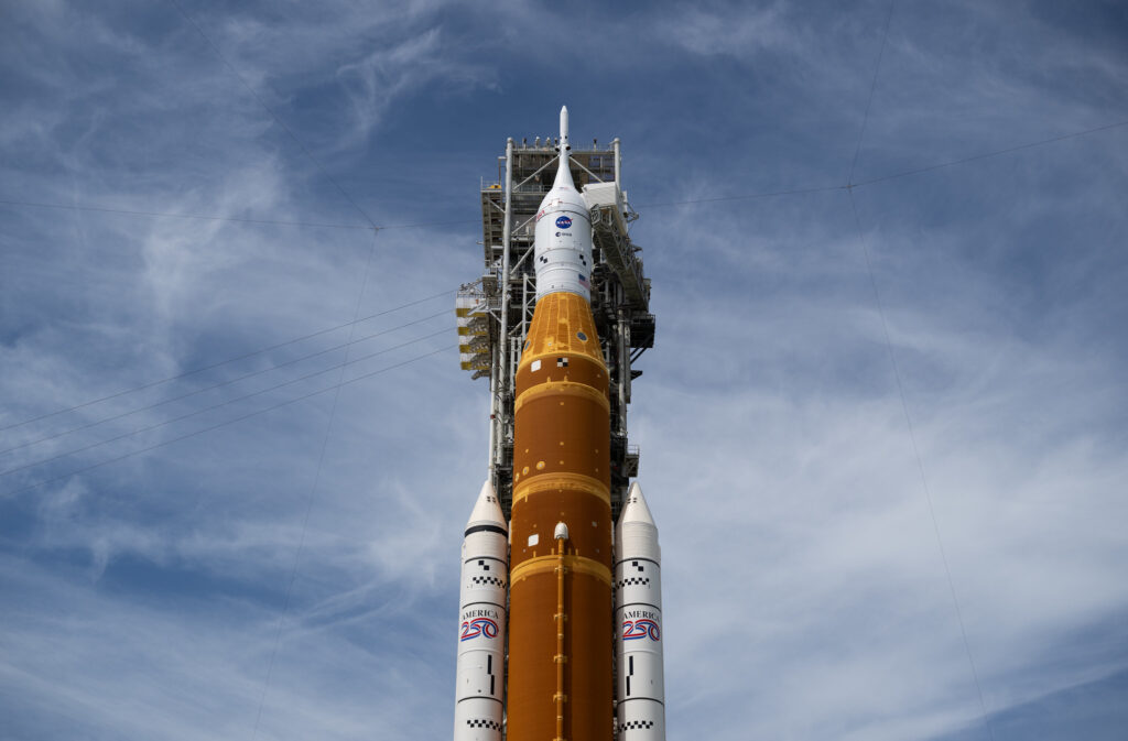
Last, I want to congratulate everyone in the Houston area (and beyond) that has been involved in the Artemis mission. I mean…wow. The mission is of course nowhere near completed yet, but to be able to share that moment with my kids, a moment that those of us born after the early 70s have never experienced was truly special. And it’s not like we just watched the launch and then went about the evening. No, we fired back up NASA’s mission stream before bed to check on them. And we will be doing that many more times for this and future launches. I am hopeful this spurs new interest in space and support of science. Time and again it’s been proven that with human ingenuity and science, great achievements are possible. To the many folks that have brought us back to this point, thank you.
Onward…
Thursday and Friday
If you were lucky yesterday, you saw some rain. I literally looked outside, said “it’s raining,” and in the time it took me to comprehend that it was raining, it stopped. I’m not exaggerating whatsoever. “Blink and you might miss it” applied. Some folks did do okay though. The Sealy area saw over 0.75″ of rain in spots, including a 1.12″ from a Harris County Flood Control District gauge north of San Felipe. There was also a corridor of heavier rainfall north of Downtown with 1.25″ at a CenterPoint gauge along Tidwell Road and 1.16″ at 59 & 610.
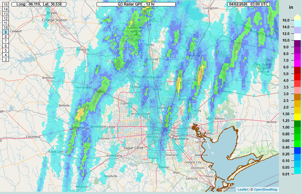
Yesterday’s rainfall came from south to north moving showers as gusty winds and Gulf moisture piled in. Yesterday was also one of the most uncomfortable days of this spring with the humidity. Today’s rain chances will be slightly different. The setup features showers and storms that are approaching Aggieland from the north and west as a boundary nudges toward the region. It’s unlikely that those storms are going to make it into the Houston Metro in an organized fashion. But some disorganized showers are already occurring across the area and a few storms are possible later this morning in places like Navasota or Magnolia or The Woodlands.
Friday will probably just feature a smattering of some light to moderate showers and nothing worse. Good news if, you’ll be attending the Dash game! Highs will be in the low to mid-80s both today and tomorrow with lows stuck in the 70s.
Saturday
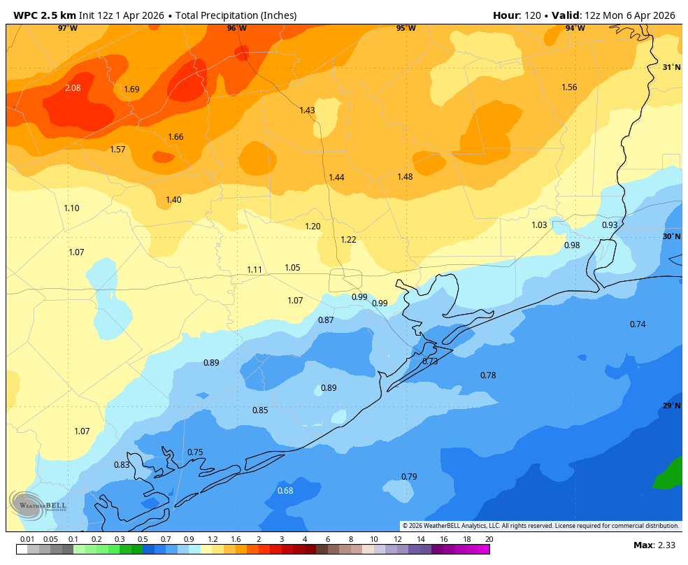
It appears that the first half of this weekend will feature our best chance for more widespread rain. That said, there continues to be some model disagreement on how resilient the coverage of that rain will be. In general, expect a solid line of showers and thunderstorms, including some that could be on the stronger side moving into the Brazos Valley early on Saturday afternoon. Those should begin to move into northwestern parts of the Houston Metro (Katy, Cypress, Magnolia north to Conroe) by late afternoon. The line of storms may peak as it enters the northwest fringe of the Houston area but then begin to fracture or fizzle during the evening hours as it moves south and east from there.
As of right now I would expect the best chances of a half inch or more of rainfall on Saturday to be north of I-10 and west of I-45, with the lowest chances south of I-10 and west of Highway 288. Rain totals may end up ranging from a quarter inch in the Wharton area to a half inch or so at the coast to 1.5 or 2 inches northwest of Houston. We’ll fine tune this again tomorrow.
Sunday
Clouds and light showers may linger on Sunday, especially south and east of Houston. It will also turn sharply cooler on Sunday. Expect highs near 70 degrees north and west to low or mid-70s south and east. An additional disturbance may pass to the south of our area Sunday evening providing a slight uptick in rain chances for the Matagorda Bay region into Galveston.
Next week
Cloud cover may linger into Monday morning, along with shower chances near the coast before things clear out a bit. This should lead to a decent Monday afternoon and Tuesday, with highs in the 70s. Morning lows will be in the 50s or even some 40s!
Rain chances may begin to slowly return after Tuesday with gradual warming.