In brief: In today’s post we look at how bad August really is in Houston, and fall back on a little post-war poetry for assistance. With regard to the forecast, we’ll be blistering hot for the next couple of days before conditions cool off slightly.
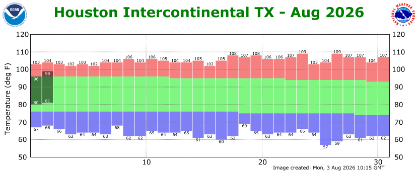
August
This is the month of no respite. This is the month, often, of no rain. This is the month of relentless heat and humidity.
This is, quite simply, the worst month of the year in Houston.
How bad is it? In the aftermath of World War I, the Irish poet W.B Yeats wrote The Second Coming about the world sliding into chaos and collapse. It is a dark and haunting poem, and I sometimes think of it when contemplating August in Houston. These lines in particular:
Things fall apart; the centre cannot hold;
Mere anarchy is loosed upon the world,
The blood-dimmed tide is loosed, and everywhere
The ceremony of innocence is drowned;
That is how I feel about August. It is the hottest month of the year, with the warmest days and muggiest nights melting all into a blood-dimmed tide. It also, historically, is when the plurality of hurricanes strike Texas (September ranks second). We often fall into miserable droughts. And by this time of year we have already gone through June and July; a steady progression of ever hotter days, a seemingly endless march toward the realm of Hades. Mere anarchy, indeed, is loosed upon our metro area’s atmosphere.
The good news—and let’s be honest, good news is in short supply at the moment—is that nothing lasts forever. We are already on August 3, and 6.5 percent of the month is behind us. Fall is not right around the corner, but it does lie on the horizon. Plausibly we could see the region’s first front in six weeks or so. And in the more near term our weather later this week should see a slight downturn in temperatures. We celebrate these small wins in August, because that’s all we can hope for.
Monday
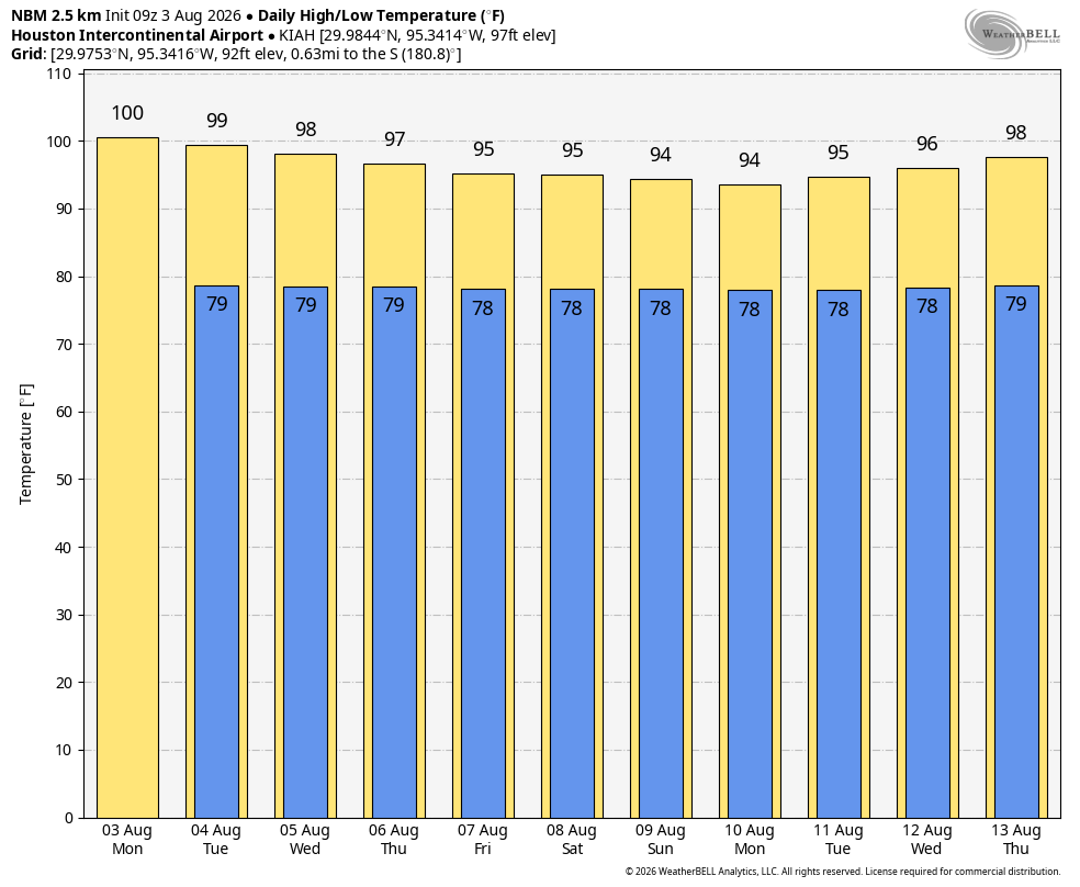
You may not have noticed it, but a weak front moved in to Houston on Saturday. Dewpoints on Sunday briefly dropped below 65 degrees in some locations, particularly north of Interstate 10. Although air temperatures were still in the upper 90s, the air was a smidge drier. There may be a similar, less pronounced, effect this afternoon. This slightly drier air will allow inland temperatures to once again push up near, or reach 100 degrees this afternoon before the sea breeze completely washes the drier air away. Areas near the coast will be a bit cooler this afternoon, but more humid. There will be about a 10 percent chance of showers this afternoon or evening. Lows tonight will be around 80 degrees, so very sultry.
Tuesday and Wednesday
These will be hot, humid, and sunny days with highs in the upper 90s (perhaps 100 degrees for far inland areas). We cannot rule out some isolated to scattered afternoon showers, but chances are probably only in the 10 or 20 percent range. Nights remain sultry.
Thursday through Sunday
Although we’ll remain in the midst of fairly high pressure, we should see a more pronounced onshore flow during the second half of this week, and into the weekend. The effect of this will likely be to increase cloud cover (from mostly sunny to partly sunny, probably) and bump up daily rain chances to 30 or 40 percent. In turn, this should help bring down daily highs from the upper 90s to the mid-90s, or likely lower-90s for coastal areas. In terms of rain accumulations I would not expect too much in this pattern, but some passing showers would be generally welcome after a fairly dry period over the last few weeks. Anyway, as August goes, things could definitely be worse.
Next week
Speaking of worse, indications are that our pattern flips back to sunnier and hotter next week. But again, this entire month is about surviving and advancing, at least when it comes to weather. At least the tropics look quiet for now.
